Daily insights for city builders, delivered every morning at 6 AM ET. I’m Brandon Donnelly — a Toronto-based real estate developer and founder of Globizen. I’ve been writing here since 2013.
In today’s post I’d like to focus on the second tweet I embedded in yesterday’s piece about downtown Toronto. Specifically, the fact that almost 75% of downtown residents walk, cycle, or take transit to work, leaving drivers firmly in the minority.
For me, this then makes me question whether or not we’re optimizing well enough for the majority. However, it’s often not that simple. And that’s because the downtown core is clearly regional in its draw, and the further you move out from the downtown core, the more the modal split flips. In the suburbs, driving is obviously the majority.
And herein lies the tension and the reason for all this “war on the car” rhetoric: We have a downtown core with completely different mobility preferences than the rest of the region.
But as Toronto continues to intensify and grow (the population of the Greater Toronto Area is projected to reach almost 9 million by 2036), I truthfully don’t know how we could reasonably expect to (efficiently) move that number of people in private cars. I’ve just never seen it done before.
Some people think that if we simply got rid of all those damn streetcars on our city streets, that we’d be doing a lot to eliminate traffic congestion. But it’s not that simple. The Highway 401 here in the city is already 18-lanes and one of the widest in the world. And yet it’s perpetually clogged. No streetcars there.
So I look at this tension as a growing pain. Sooner or later I think we’re going to realize that this war should really be a war on inefficiency. How do we move lots of people around big cities while minimizing waste, maximizing economic output, and enhancing quality of life?
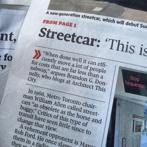
In anticipation of our new streetcars beginning service this Sunday, the Globe and Mail published an article on Friday called: Why Toronto is still a streetcar city. And I was quoted as saying the following:
I had no idea that I was going to be cited, but I like the quote that was chosen. The key words are: “when done well.” There are a myriad of different ways in which a city can implement streetcars, and each will have varying degrees of performance.
So if you’re one of those people who are critical of streetcars, I would encourage you to think about streetcars not just in terms of how they’re implemented today in Toronto, but also in terms of how they could be implemented going forward.
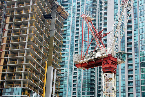
Earlier this week, Toronto City Council approved the equivalent of 755 storeys of new development, a lot of which will end up in the downtown core. The translates into 6,887 new housing units and roughly 4 million square feet of new commercial space. The Globe and Mail called it the Manhattanization of downtown.
If you’d like to go through the complete City Council meeting agenda, you can do that here. (I warn you though, it won’t be an exciting read.)
One notable project that was approved is 50 Bloor Street West, which is a 71-storey mixed-use building in Yorkville adjacent to and on top of Holt Renfrew (It includes a $6 million Section 37 contribution). I mention this one because it’s impressively tall and because it’s a project that I was involved with when I was at Morguard. Watch for Yorkville in the coming years, there’s a lot in the pipeline.
While I think this is all incredibly exciting, our chief planner, Jennifer Keesmaat, is entirely correct in pointing out that all of this highlights the desperate need for better infrastructure, the most critical of which is a relief subway line that cuts across downtown.
But to be clear, this isn’t a question of just planning for growth. This is a question of planning for growth and making up for decades of infrastructure disinvestment. That’s the position we’re in today, which means we have a lot of hard work to do. Though I’m confident we’ll get it done.
The other thing that this level of intensification should highlight for you is that public transit, and other forms of mobility such as biking and car sharing, have to be central to our goals. It’s simply infeasible for everybody to be driving around in a car. We’re currently demonstrating how efficient that ends up being.
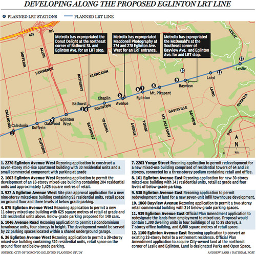
Last week The National Post published an article talking about Toronto’s Crosstown LRT and how it’s spurring a wave of development all along Eglinton Avenue. Below is a map, taken from that article, showcasing some of the developments that are currently in the pipeline and awaiting the Crosstown’s opening date of 2020.
Not surprisingly, developers like transit investment. But more specifically, they like fixed track transit investment. Rarely do new bus routes elicit the same sort of response that you’re seeing above. And that’s because fixed track investment has permanence. If you’re going to go long on an area, you want certainty.
As the Crosstown tunnel boring machines move across midtown Toronto, I thought it would be interesting to look at a transit concept that I first learned about through Jarrett Walker’s Human Transit blog. It’s called: the radius of demand.
One of things that transportation planners look at when designing and building a new line is the spacing of stops. Typically, as you move from buses all the way up to subways, the spacing between stops and stations increases. Spacing is always a bit of a trade off though, because more stops means easier access for riders, but it also means slower overall service. Somewhat famously, Paris designed its metro system so that you’re rarely more than 500 meters away from a station.
Once you have your station locations, it’s quite common to then draw a radius around each stop to simulate the catchment area. In other words: How much of the city can I service with this station and how far will people be willing to walk in order to get there? However, this distance, which is the radius of the circle, usually depends on the type of transit. Oftentimes people are willing to walk further in order to get to faster transit service.
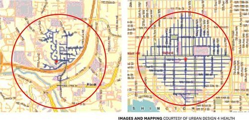
But what’s most interesting about this radius of demand is that it’s entirely dependent on the fabric of the city. Take for example, the following two maps from Seattle, which I have taken from Walker’s blog. On the left is a suburban setting and on the right is a downtown setting. In both cases, the red circle represents a 1 km radius.
Now, if humans could fly over barriers, such as highways, and every Seattle resident was willing to fly exactly 1 km to a transit station, these two radiuses of demand would be perfectly accurate. But since that’s not the case, we instead need to look at what actually represents a 1 km walk – those are the blue lines in each image.
Because once you do that, you realize that the cul-de-sacs and highways on the left make it impossible for most of that radius of demand to actually walk to the station in under 1 km. So the catchment area actually becomes much smaller. On the other hand, if you look at the image on the right, you’ll see that the tried and true city grid is actually remarkably efficient for walking. Almost all of the circle is serviced.
So as the Eglinton Crosstown LRT makes its way through the center of Toronto, I think it’s important to keep in mind that it’ll be cutting through quite a few different kinds of street grids. Some of them will be highly conducive to transit usage and others not as much. And in many ways, this is one of the greatest challenges of transit investment. The track itself is only one part of the puzzle.
That’s why the City of Toronto is also undertaking a planning exercise called Eglinton Connects. Its intent is to leverage the opportunities, as well as address the challenges, that will result from Metrolinx’s Crosstown LRT. If you’re interested in the future of Eglinton Avenue, you should consider getting involved. Oftentimes it’s only the critics that speak up. But that’s not the best way to build anything.
Last night my father and I were walking to dinner and he commented to me that he thinks my generation will be a lot healthier than his–at least on average–given how much more my generation walks. I responded by reaffirming to him how little I drive these days and how much I enjoy that.
Then today, I was watching this short clip of the The High Road with celebrity chef Mario Batali, where he interviews venture capitalist Fred Wilson. During their tour around New York City, Mario asks Fred what he thinks the future of transportation will be. Fred responds by saying that nobody will drive anymore. He then went on to say that the technology for driverless cars is already ready, but that we as a society just aren’t ready for it, yet.
Finally, on my way home from wakeboarding today, I stumbled upon this Guardian Cities article talking about Helsinki’s ambitious plan to make owning a car pointless. By 2025, the goal is have a “point-to-point mobility on-demand system” that will integrate all forms of mobility into one booking and payment platform. Think everything from public transit to carpools to taxis.
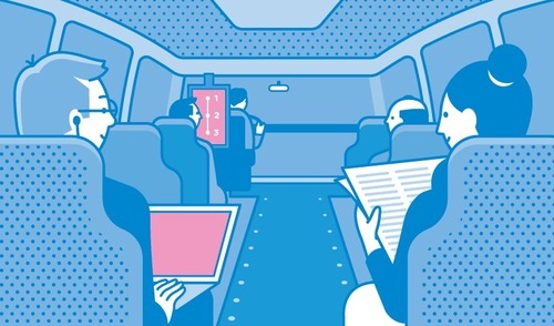
As I read on, I then discovered that Helsinki is already offering on-demand public minibuses that allow people to specify their own routes on their smartphone. The system then aggregates all of the requests and establishes the most efficient route based on the immediate demand. Coincidentally enough, it’s quite similar to a use case I wrote about for driverless cars.
All of this got me thinking that one day we’ll probably look back at that time when people used to drive their own vehicles around as some antiquated and hilarious moment from the past.
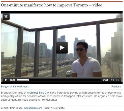
The video was shot on the sundeck of my building on a holiday Monday (meaning traffic volumes should have been less). The dirty glass makes the city look a lot smoggier than it really is, but it felt appropriate for the topic I was discussing.
I’m sure many of you will disagree with what I’m advocting for, so let me know your thoughts in the comment section below.
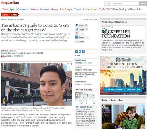
ATC was featured in The Guardian Cities today as the city blog of the week. It’s a Q&A about Toronto and the idea is for it to be an “urbanist’s guide” to the city. They asked me to be playful and humorous in my responses, and so I tried to do just that.
But my underlying message was that–despite being an awesome city–Toronto needs to get its act together with respect to mobility and transportation. I also recorded a video talking about this problem, which I believe will be released in the next week or so.
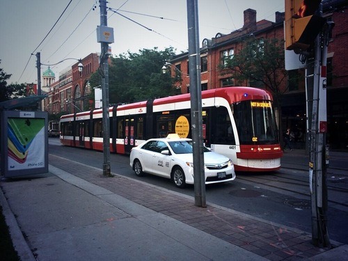
Tonight I saw one of Toronto’s new streetcars cruising down King Street. They’re still in test mode and the first batch won’t go into operation until this August, but every now and then you’ll see one circulating around the city. This was the first one I’d seen in person.
If you’re a transit geek or urbanist, you’re probably excited about the arrival of these new streetcars. But I know that there are a lot of people who aren’t. They hate streetcars and they think of them as basically rolling stop signs on our congested downtown streets. And since these new streetcars are even longer than our existing ones, they’re worried they’ll just make the situation worse.
Personally, I think that streetcars mixed into traffic is generally pretty inefficient. But I know that surface light rail has the potential, when executed properly, to be a cost-effective and sustainable way of efficiently moving lots of people around a city. When I lived in Dublin I took the Luas every day. It was great.
So I’m curious to hear from you. What do you think of Toronto’s new streetcars? Let me know in the comment section below.
One of the things that many city planners, transportation experts, and municipalities are trying to figure out is how to successfully shift people away from driving towards alternative modes of transportation, such as biking and transit. Now, this is no easy task. There are a myriad of factors that influence a person’s decision to drive or not drive–or if they should even own a car in the first place. Though, land use and density are, in my opinion, probably the biggest.
But of all the solutions thrown around, mobile apps are typically not within the playbook. However a recent New York Times article is making the argument that it should be, because car-sharing services and apps like Uber seem to be indeed having an affect on people’s decision to own a car. And that’s because in some cities it’s actually cheaper to use Uber every day (than to own a car) and because taxi use has been shown to correlate with other (non-driving) forms of mobility.
Paradoxically, some experts say, the increased use of ride-sharing services could also spawn renewed interest in and funding for public transportation, because people generally use taxis in conjunction with many other forms of transportation.
In other words, if Uber and its ride-sharing competitors succeed, it wouldn’t be a stretch to see many small and midsize cities become transportation nirvanas on the order of Manhattan — places where forgoing car ownership isn’t just an outré lifestyle choice, but the preferred way to live.
And to be honest, I don’t think this is all that far stretched. More and more I find myself wondering why I even own a car. It’s not appreciating sitting downstairs in my garage and, given the frequency in which I use it, I would definitely be better off financially if I simply used an app like Uber or Hailo more often. About the only thing those apps aren’t great for are trips to Home Depot and snowboard trips to the mountain.
If there are two things we like to talk about here in Toronto it’s that there are a lot of condos going up and that it’s becoming increasingly difficult–some would say impossible–to get around. Just this past weekend, I had 2 or 3 people tell me that biking is the only practical way to get around downtown and that it’s fairly easy to outwalk a streetcar on either Queen Street or King Street.
Usually these statements are followed by a question, asking what the city is doing to address these issues. The unfortunate reality is that I think urban mobility is going to get worse before it gets better (although I am thrilled about the Eglinton Crosstown line now under construction). If you’re a regular reader, you’ll know that I’m a supporter of a Downtown Relief Subway line and that I was disappointed by John Tory’s recent transit proposal.
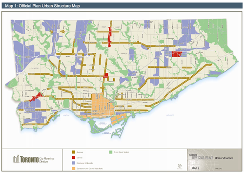
The best way to explain why I feel this way is to talk about how and where Toronto is growing. In my post on John Tory’s transit proposal, I talked about how Toronto is developing in the shape of an upside down letter T. And the reason for that is because in the city’s Official Plan, the “Downtown and Central Waterfront” area is identified as a growth node and is shaped more or less like an upside T. It’s the light orange in the following map.
In addition to the downtown core, the areas shown in red are earmarked as “Centres” for growth. There’s one in each borough (Etobicoke, North York and Scarborough) and one at Yonge & Eglinton, which most people would consider to be the heart of midtown. Finally, you have the “Avenues” which are the greenish brown lines on the above map. Those are areas that city also hopes will accommodate future growth.
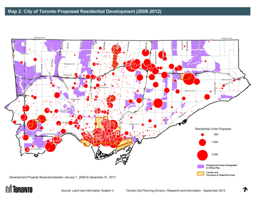
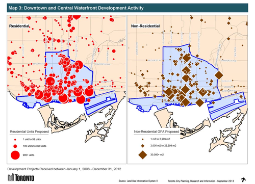
Now, let’s look at where development is happening in the city. Here’s residential development from 2008 to 2012. The biggest circle represents 2,000 proposed residential units.
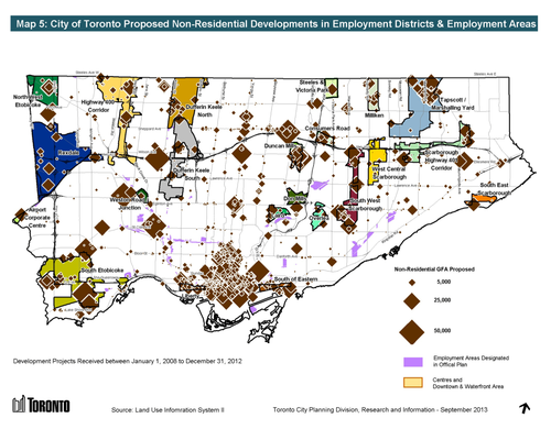
And here’s non-residential development. The largest diamond represents projects with a non-residential floor area greater than 50,000 square meters (~540,000 square feet).
What should become immediately apparent is that growth–particularly on the residential side–is happening more or less according to plan. The biggest “outliers” are really the development happening along Mimico’s waterfront and all the development happening along Sheppard Avenue East. But those are because of the water and the Sheppard subway line.
In both the residential and non-residential cases though, the downtown and central waterfront area is quite clearly receiving a significant share of the development happening in the city.
Which always makes me wonder: Why are we so reluctant to build proper transit in the core?
The city’s Official Plan is clearly funneling growth to downtown and yet we continue to propose, fund, and build subway lines in areas where the population densities are lower and ridership levels will inevitably be less. Which ultimately means that the required government subsidies to keep those lines operating will be higher.
I’m not suggesting that the inner boroughs don’t also need top notch transit and infrastructure. They absolutely do. But I get frustrated when politics trumps rational city building. And so does everybody else who’s stuck with inadequate mobility options.