Daily insights for city builders, delivered every morning at 6 AM ET. I’m Brandon Donnelly — a Toronto-based real estate developer and founder of Globizen. I’ve been writing here since 2013.

Tag: transportation

  • How urban density affects how you get around

    Yesterday I wrote about urban-suburban divides within cities. And I argued that built form will largely dictate the kinds of transportation choices that people will ultimately make.

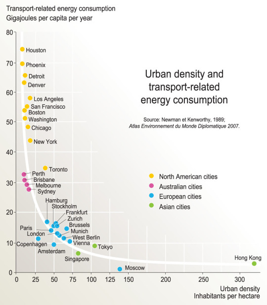
    As a follow-up to that, here is a chart based on the findings of a research report completed by Peter Newman and Jeffrey Kenworthy way back in 1989. On the x-axis is urban density (i.e. built form) and on the y-axis is per capita transport related energy consumption.

    image

    What this chart shows is that as cities become more dense, “automobile dependence” is reduced in favor of, other, more sustainable forms of transport. 

    Here we have Houston at the top left (meaning it has the highest transport-related energy consumption per capita) and Hong Kong all the way on the bottom right. Hong Kong has by far the highest density among the cities looked at in this study, but Moscow seems to have the lowest per capita energy consumption. Still, the trend appears clear.

    Some people think of “density” as a dirty word. But there are lots of benefits to dense urban centers. And density does not necessarily have to mean tall buildings.

    Chart: Globalization Studies in an Urban World (Penn)

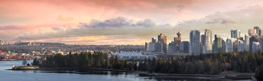
  • Vancouver isn’t immune to the urban-suburban divide

    https://500px.com/embed.js

    In the comment section of my post about Vancouver’s transit referendum, a reader suggested I take a look at an article by Peter McMartin called, The real Vancouver emerges (from the ruins of the plebiscite)

    McMartin’s argument is basically that Vancouverism – the name given to the city’s progressive architecture and planning approach – isn’t as widespread as it might seem. The reality is that Vancouver, much like Toronto and other cities, is divided.

    “Vancouverism might be a reality for two or three neighbourhoods huddling in the downtown, and that greener, more progressive ethos might hold sway in one or two more.

    But Vancouver — and I speak of it in the metro sense — is the sum of its parts, and most of its parts are suburban in their sensibilities, and that includes not just all of the suburbs but most of the neighbourhoods in the City of Vancouver proper.

    They’re resistant to change. They abhor densification. They’re conventional in their sensibilities and they’re highly dependent on the automobile. More importantly, they’re not just dependent on the automobile, they prefer it.”

    Here in Toronto, we know our city is divided. And many people see it as evidence that amalgamating the city in 1998 was a big mistake. The inner suburbs are holding back old Toronto and elitist old Toronto just doesn’t understand the priorities of the inner suburbs.

    But I’m not convinced that amalgamation is to blame.

    Most cities have long histories of amalgamating adjacent towns, villages, and cities, and I suspect that there was opposition all along the way. At what point is amalgamation acceptable and and what point is it problematic?

    The anti-amalgamation camp here in Toronto seems to believe that it would have allowed old Toronto to continue doing what it wants to do and allowed the inner suburbs to do what they want to do.

    But this to me feels parochial.

    Our cities need to think bigger than that. We need to think as cohesive urban regions. And as Vancouver demonstrated this past week, that’s not always easy. But I don’t think the answer is to just think smaller and ignore the people whose views don’t match our own.

    Interestingly enough, what a lot of this comes down to, I think, is built form. 

    Because different kinds of built form will encourage and often mandate different kinds of transportation choices. And how you get around a city will inform a big part of what you value and what you vote for.

    Over time though, I believe that we will see built form start to level out across our city regions through continued intensification. Many people won’t be happy about this change. But it is likely that it will end up creating more cohesive cities. 

    Built form is no small thing.

  • Teaming up to fix Toronto’s traffic troubles

    image

    “This will be a game changer and will establish Toronto as a leader in running a truly smart city.”
    – John Tory, Mayor of the City of Toronto

    Yesterday I registered for a hackathon called TrafficJam that’s taking place this October 2 – 4, 2015 here in Toronto. It’s being organized by Evergreen CityWorks and the City of Toronto, with the goal of fixing Toronto’s traffic troubles.

    Tickets are free, but going fast. If you’re interested in this sort of thing, I would encourage you to sign up today. And if you do register or are already registered, drop me on a line so we can connect. I’m excited to see what kind of solutions we’re all able to come up with over the course of a weekend.

    But as I was registering and reading through the website, I couldn’t help but think about some of the traffic problems that we won’t be solving over the hackathon weekend, namely the politicization of transportation planning in this city.

    As an example of that check out a post by transit blogger Steve Munro called, The Vanishing Relevance of SmartTrack

    SmartTrack is the transit platform that Mayor John Tory ran on last year. And this post explains why it is unlikely to achieve its pitch promises.

  • The PRESTO Push

    image

    Back in 2004, I spent a summer living in Asia. And one of the things that I remember really standing out for me was Hong Kong’s Octopus card. It’s a refillable card that you just tap to get onto transit. Lots of cities have them.

    But the cool thing about the Octopus card was that you could use it so many other places besides just on transit. I don’t know know what it’s like today in Hong Kong, but I remember also using it in taxis and to buy breakfast in the morning at Pret a Manger. That was pretty incredible for 2003.

    This was also great for me because I’m one of those people that dislikes carrying around paper money/change. I almost never spend my change and so it just ends up just accumulating in a container beside my front door. Here in Toronto we also use microscopic transit tokens, so that adds another layer of inconvenience.

    But that’s all changing.

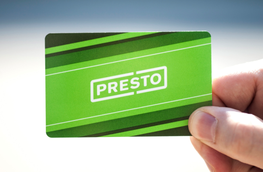
    Toronto now has its own version of the Octopus card and it’s called PRESTO. Technically it launched in 2009, but I only recently noticed the card readers appear at my home subway station (King Station). So tonight I decided to finally pull the trigger and order a card. I’ve been waiting 11 years for this moment 🙂

    And I was doing that, I noticed this message on the website:

    image

    Not surprisingly, we seem to be pushing to get PRESTO rolled out before the world comes to visit. And I think that’s a great thing.

    One of the big benefits of hosting an event like the Pan Am Games or the Olympics is that it creates a hard deadline to get things done, which is something governments often need. It’s a bit like tidying up before guests come over for dinner. You find a way to do it before people arrive.

    There’s a lot of debate about whether or not it makes sense for cities to spend the money on playing host city. But I don’t think we should ignore the fact that they can be a great catalyst for city building. Things get done. And oftentimes done is better than perfect.

    Good news: I’ve been told that the PRESTO system will be compatible with mobile phones and near field communication. Because let’s face it, cards won’t be around that much longer.

  • Gardiner East vote shows that Toronto is not yet ready to be an urban leader

    image

    Today is very sad day for Toronto. 

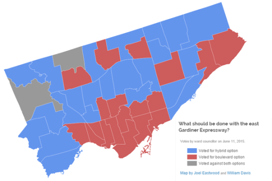
    After 2 days of debate, City Council voted this afternoon, 24-21, in favor of rebuilding the elevated Gardiner Expressway East (”hybrid” option) that runs along the city’s eastern waterfront.

    And once again, Toronto is largely divided. See above image prepared by Joel Eastwood and William Davis.

    It’s the old city of Toronto (who uniformly wanted the elevated highway replaced with a boulevard) versus the rest of the city (who for the most part voted for the hybrid).

    I can’t begin to tell you how deeply disappointed I am by not only the outcome, but also by how it happened and why it may have happened. For all of our talk about being a progressive global city, today we are clearly not that. 

    Because more than a vote on what to do with the Gardiner East, today was a vote on how we believe we should be building this city for the future. 

    When the Gardiner East was first built, the vision was one of fluid private mobility, where it would be possible to quickly circle around and across the city on an endless sea of highways. Detroit was doing it. Baltimore was doing it. Everybody was doing it.

    In other words, we were building our environment around the car. And our primary – some would say singular – focus was to ensure that the car could move unencumbered around the city. That’s why Toronto is now home to the busiest and one of the widest highways in the world.

    But despite all this, Toronto remains crippled by gridlock. And so does every other big city city in the world that has bet on cars as the solution. Why is that?

    Because that model doesn’t work.

    The I-10 Katy Freeway in Houston is 26 lanes at its widest point. It is the largest highway in the world by number of lanes. But from 2011 to 2014, commute times in some sections increased by as much as 51%. Is that because they haven’t built enough highway? How much is enough?

    By comparison let’s look at a city that has bet on transit as the solution: Tokyo. 

    The metropolitan area of Tokyo is approximately 37.8 million people. That’s more than the entire population of Canada and by most accounts is the largest urban region in the world. But despite its size, Tokyo is consistently ranked as one of the most livable cities in the world and also one of the most efficiently run.

    Interesting.

    So when I heard Councillors going on today about how a vote for the “hybrid” is a vote not to increase congestion and gridlock, it became abundantly clear that many – apparently most – people in this city still do not appreciate what it is going to take to get us efficiently moving as this region approaches 10 million people by 2041.

    This should not have been a debate about 3 minutes. That, as I’ve said before, is a red herring.

    Of course, there was lots of lip service to transit. Many seemed to agree that transit is the future. And some even went so far as to say that removing the Gardiner East and replacing it with a boulevard is the right thing to do, but that we simply can’t do it now because we haven’t made the requisite investments in transit. 

    If transit is truly what we want, then we why don’t we take the boulevard savings and put it directly into transit?

    To me it’s like saying: I really want to be homeowner, but I can’t afford it right now. So instead, I’m going spend more on rent so that I can burn through more money and make it even more difficult for myself to eventually become a homeowner.

    Because that is what happened today. 

    We voted to overspend on a stretch of elevated highway that is used by a small sliver of downtown commuters (~3%), instead of replacing it with a cost-effective surface boulevard (with similar road capacities) and then prioritizing the proven solution to urban congestion: transit.

    At the same time, we also made a number of other things clear in today’s vote. 

    We made it clear that cars matter more than our city’s public realm; that cars matter more than our waterfront revitalization plans; that cars matter more than our environment and our “efforts” to reduce GHG emissions; and, frankly, that cars matter more than our overall quality of urban life.

    I believe that cars will always be a part of our cities, but I don’t believe in putting them ahead of you and I. I guess old habits die hard. That my friends, really sucks.

  • Walking the West Side Highway

    image

    I am in New York this weekend. Every now and then I need to get my fix of this city. I just love it here.

    Given the debate that’s going on in Toronto right now about the elevated Gardiner Expressway, one of the things I wanted to do this weekend was walk the West Side Highway. The West Side Highway runs along the western edge of Manhattan from 72nd Street all the way down to the southern tip of the island. It used to be an elevated highway, but it runs mostly at grade now.

    I’ve been to and on it many times before, but I wanted revisit it with a different lens. Many people in Toronto seem to think that if we remove the Gardiner East and replace it with an enlarged Lake Shore Blvd that it would pose just as much of a physical barrier as an elevated structure.

    So I walked the West Side Highway and filmed this (Hyperlapse) video:

    //platform.twitter.com/widgets.js

    I think it’s a big improvement over an elevated structure. What do you think?

    There is, however, an elevated highway uptown. So tomorrow I plan to travel it on a scooter that I’ve rented to see how the urban fabric changes around it. I suspect it’ll be quite different.

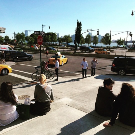
    In case you were wondering, the picture at the top of this post is from the steps at the Whitney Museum. They face the West Side Highway and the water. It’s a great public space, but I’m pretty sure that Renzo Piano wouldn’t have designed it that way (and with that orientation) had there been an elevated highway in front of it.

  • A Jane’s Walk about the Gardiner Expressway

    image

    This May 2nd at 1:00pm I’m going to be participating and speaking at a Jane’s Walk here in Toronto called, Gardiner Expressway: To be or not to be? 

    The other “walk leaders” include Andrew Hilton, City Councillor Jaye Robinson, Ed Levy, Kyle Baptista, and architect Les Klein (Quadrangle Architects).

    This will be my first time going to a Jane’s Walk, but it’s clearly a topic that I’m interested in. For over a year I have been arguing that we should remove the Gardiner East (the portion east of Jarvis Street).

    This has proved to be a contentious position and topic. One critic said that I only want to remove the Gardiner East so that – as a real estate developer – I can make it harder for people to get into the city, which in turn will force them into buying more condos in the city. 

    That was not my thinking.

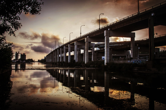
    Instead, I view it as an opportunity to truly unlock the eastern portion of Toronto’s waterfront and the Portlands area. Take a look at the Keating Channel (shown above) and tell me whether or not you could imagine a better and more urban kind of waterfront. I get excited when I think of the potential.

    And, if we’re going to do this, I believe now is the time, before the area gets developed. Because once it gets developed around the Gardiner, things will never be quite the same – even if we do eventually remove or bury it.

    Click here for more information on the Jane’s Walk. Please also keep in mind that there will be many other viewpoints expressed at the Walk. This is just mine.

    Image: Gardiner Expressway and Don River, Flickr

  • The new Toronto 2030 District

    Photograph Financial District, Downtown Toronto, Canada by Yeonju SEONG on 500px

    Image: Financial District, Downtown Toronto, Canada by Yeonju SEONG on 500px

    Today I learned about something new called 2030 Districts. They are: “designated urban areas committed to meeting the energy, water, and transportation emissions reduction targets of the 2030 Challenge for Planning.”

    Toronto’s new 2030 District is downtown, which is bound by the lake in the south, Bathurst Street in the west, Dupont Street and Rosedale Valley in the north, and the Don Valley in the east. 

    It’s the first district outside of the US. The other established districts are in Seattle, Pittsburgh, Los Angeles, Denver, Stamford, San Francisco, and Dallas.

    The goals for Toronto’s district are as follows (quoted from 2030 Districts):

    • To cut district-wide emissions in half, including zero-emissions from new buildings by 2030.
    • Support a better understanding of where and why energy use, water use, and GHG emissions occur across the District.
    • Work in partnership with building owners, service providers and conservation groups to accelerate the adoption of best practices for building design and management.
    • Facilitate broad stakeholder dialogues to uncover and overcome systemic barriers to long term reductions in energy use, water use and GHG emissions.

    I’m looking forward to following and learning more about this initiative. I think many of us can agree that producing less, not more, GHG emissions in the future would be preferable. And we know that the bulk of it comes from both buildings and transportation.

  • “Project Snowball” cracks down on UberX drivers in Toronto

    https://500px.com/embed.js

    This afternoon I saw on Twitter that Toronto Police are now starting to crackdown on UberX drivers in the city. The investigation is called “Project Snowball” and they have already charged at least 11 people. The fines are anywhere from $200 to $20,000.

    My response on Twitter was the following:

    I get that Uber is a highly disruptive company. I’ve written about it many times before. But at the end of the day, this is not just about Uber. This is about a larger shift in the economy.

    The buzz term is “sharing economy.” But one of the ways I like to think about it is like so: Facebook doesn’t produce any of its own content, and yet you could define it as a media company. Airbnb doesn’t own any rooms, and yet it is disrupting hotels. Uber doesn’t own any cars or plates, and yet it is disrupting the taxi industry.

    What’s happening is that the internet and mobile phones are allowing for peer-to-peer connectivity and more decentralized forms of marketplace supply.

    What does that mean?

    It means that instead of having a fleet of cars or a centralized hotel building, anyone with an extra car or an extra room (and an internet connection) can plug themselves into the market. And that represents an entirely different cost structure for businesses.

    It’s worth noting that prior to Uber, Travis Kalanick founded a peer-to-peer music sharing company called Scour (1998). Its closest equivalent would have been Napster. Remember Napster? This is not a new trend.

    That said, I still think we’re at the early stages of this shift. I predict that many other industries will see disruptors similar to Airbnb and Uber. And so when I look at it in this context, I have a hard time believing that fining UberX drivers is the most enlightened way forward.

    I believe we should instead be taking a leadership position and trying to figure out how to adapt our rules and regulations to this changing economy. Toronto is not alone in this battle. But we could certainly be the one to lead the way out.

  • What do you want to read about on Architect This City in 2015?

    Photograph Schönefeld by Vladimir Smirnov on 500px

    Schönefeld by Vladimir Smirnov on 500px

    Though this blog is focused on cities and geared towards city builders, I cover a lot of different topics. 

    I talk about real estate, architecture, planning, transportation, technology, and even personal topics. My primary goal is to create a worldwide community of people passionate about building great cities, but at the same time it’s still a personal blog.

    Usually I just write about whatever is currently on my mind. I never queue up posts and so each post is written the day of. But sometimes I wonder if I’m delivering on what you, the readers, really want to read and talk about. 

    So today I thought I would simply ask: what would you like to see more of on ATC in 2015? Let me know in the comment section below and I’ll try my best to deliver.