Daily insights for city builders, delivered every morning at 6 AM ET. I’m Brandon Donnelly — a Toronto-based real estate developer and founder of Globizen. I’ve been writing here since 2013.

Tag: transportation

  • Mass transit with on-demand service

    Here’s what we know:

    In the mid-20th century, the US made a pivotal choice that shaped its cities, economy and lifestyle. It chose highways and cars over public transit. At the time, this seemed like the future: the freedom of the open road, the allure of suburban living, and the booming post-second world war economy all converged to push America towards a car-centric culture.

    The Federal-Aid Highway Act of 1956 cemented this vision, unleashing a highway system that encouraged suburban sprawl, fuelled the automotive industry and sidelined public transit. Rail systems were seen as relics of a slow, industrial-era technology ill-suited to America’s postwar aspirations. The car was king. 

    But this congested system is breaking. In 1950 about 30 per cent of the world’s population lived in cities. By 2030 this is expected to reach 60 per cent. Infrastructure cannot keep up with this growth. An increase in cars further reduces street capacity.

    What we don’t have a clear consensus on, though, is the path forward. Is it more highways? More public transit? More bike lanes? Or will autonomous vehicles finally arrive and bail us out? The answer will depend on who you ask.

    In this recent opinion piece, venture capitalist Vinod Khosla makes the case for something else: personal rapid transit systems (or PRT). Conveniently, he also happens to be an investor in one — a company called Glydways.

    The promise is an on-demand mass transit system that offers the convenience of a personal car, but with the capacities and price points of public transit. And it is based on small autonomous vehicles riding in their own dedicated lanes.

    Each lane only needs to be 1.5 meters wide, which is less than the 2.3 meters that the Dutch see as the ideal width of a one-way bike lane. And with this, the company claims that it can reach capacities of up to 10,800 people per hour.

    To further put this into perspective, the standard width of a two-way parking drive aisle here in Toronto is 6 meters. So this would mean that each drive aisle could, in theory, have 4 lanes dedicated to these “Glydcars.” That’s how narrow they are.

    Here’s a video of them in operation:

    This, of course, isn’t an entirely new idea. You might remember that Masdar City in Abu Dhabi claims to have opened the world’s first PRT system in 2010 — a 1.4 km line with only two stations. That said, Glydways has already been awarded three projects in the US. So for fun, I think I’ll keep an eye on them.

  • The Ontario Line is happening

    Yesterday afternoon, I took the 504 King streetcar from the Bloor-Dundas West mobility hub down to King & Bathurst to meet a friend at the Wheat Sheaf Tavern. In case you didn’t know, this is believed to be the oldest continually-operating pub in the city. It opened in 1849.

    My streetcar ride took an obscenely long time (over an hour) and so it was the wrong mobility choice for a peak summer afternoon. I should have biked. But once I did finally arrive at Toronto’s oldest pub, it was great to see all of the activity happening right at the intersection for the new King-Bathurst subway station (Ontario Line).

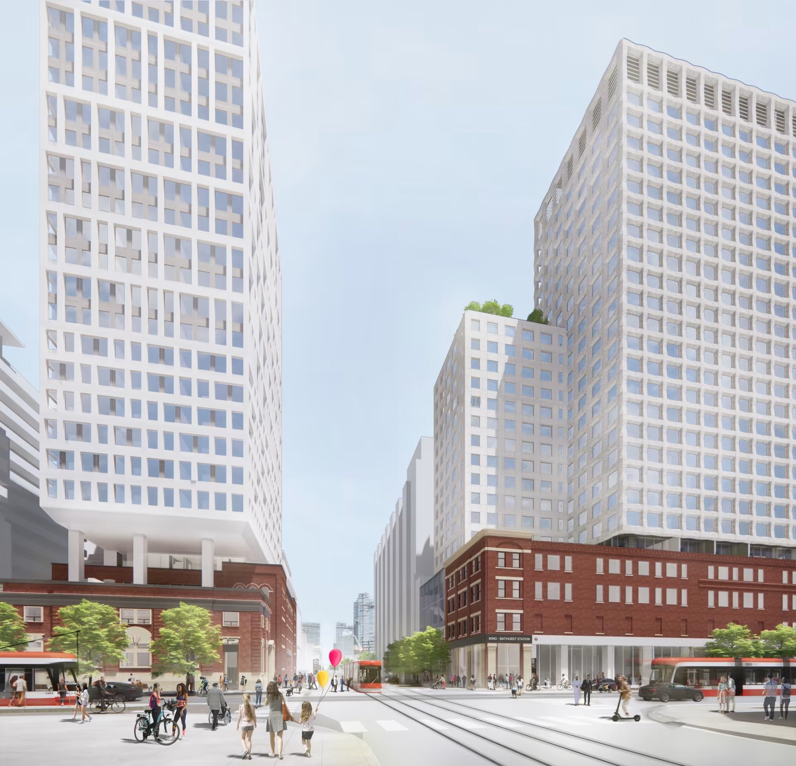
    I’m always a bit cynical when it comes to transit plans. Like, it’s hard for me to believe that something is actually happening. I’m still waiting for SmartTrack to open. So I need constant visual reminders like these:

    What you are seeing above is the northeast corner of the intersection, which is where one of the two station entrances will go. Naturally, the station platform and track itself are also aligned on a diagonal so as to minimize “significant construction impacts” to the Wheat Sheaf (southwest corner).

    This stop is also one of Infrastructure Ontario’s Transit-Oriented Communities, which means the intent is to have a private developer build things on top of the station. Directionally, this is, of course, the right approach. It didn’t happen on the Eglinton Crosstown line; but we know that the best way to maximize the value of transit investment is to combine it with smart land use planning (the rail + property model). Density is your friend.

    From what I could glean during my time on the patio at the Wheat Sheaf, all of this appears to be moving forward. And already today, there is a ton of foot traffic in the area — meaning the future transit station should do very well from a ridership perspective. Now we just need this line extended up to the Bloor-Dundas West mobility hub so that the 504 streetcar can be relieved of some of its duties.

    Station Plan/Rendering: Metrolinx and IO

  • Using maps on a bike

    I have started using Apple Maps when I cycle. I’ve been using Apple instead Google because it automatically pairs with my watch and tells me (through vibrations) when I need to turn somewhere, but I’m not here to argue that one is better at navigating than the other.

    What’s great about using either Apple or Google Maps is that it will take you on routes that have bike lanes or, at the very least, routes that have less vehicular traffic.

    Toronto’s cycling network is far from complete. But I have been impressed by how far I can go on dedicated lanes and by how many lanes/trails exist that I didn’t know about. Here is the city’s 2024 map showing only dedicated bikeways:

    It is not fun riding a bike when you have to fight with city traffic. And so this is a great way to try and avoid that, and not think too much about which routes you should be taking. It’s also a great way to test the completeness of your city’s biking network.

    I’m glad that Toronto is becoming a much better place to ride a bike.

  • Montréal is making yet another case for pedestrian-only streets

    There are parts of Toronto that are pedestrian only. There’s the Distillery District, some small laneways in Yorkville, the Toronto Islands (though this is a bit of a unique situation), and various other pockets around the city.

    There are also streets that we temporarily open up to only pedestrians, such as Market Street and King Street, and areas, such as Kensington Market, that we have been rigorously considering pedestrianizing for as long as I can remember.

    What is clear is that pedestrian-only streets are controversial. Motorists fear that it will make driving in the city even more inconvenient. And businesses fear that it will limit their customer base.

    While it is true that not all streets can and should be pedestrianized, there are countless examples of streets and areas that appear to be thriving because of it.

    Take, for example, Montréal.

    Since 2021, the city has been pedestrianizing a stretch of 30 blocks along Mont-Royal Avenue during the summer months. And according to Mayor Valérie Plante, the commercial vacancy rate for the street has dropped from 14.5% in 2018 to 5.6% in 2023:

    Maybe you don’t want to infer causality here, but at the very least, it seems to suggest that the street isn’t dying and bereft of human activity. This year, pedestrianization is also planned to be extended further into the fall.

    This won’t necessarily be the outcome for all streets, but I do agree with this recent Globe and Mail article that, oftentimes, the reasons for not pedestrianizing are “a question of philosophy, not geography.” Because there’s lots of research and data to support doing this.

    If any of you are business owners along Mont-Royal, I’d love to hear about your experiences and how you think, for better or for worse, it has changed the area. Leave a comment below or drop me a line.

  • Just give me the fastest option

    I had a dinner in the suburbs this evening. And so in the afternoon today, I opened up Google Maps to figure out how I was going to get there.

    I didn’t have my car with me — because I hate driving into the office — so in my mind, I was either going to take transit or take an Uber.

    These are the time estimates that Google gave me:

    It was going to take me over 4 hours to walk there. Over an hour to drive there. And 47 minutes to take the train there. Interestingly enough, cycling was also going to be faster than driving.

    As soon as I saw this, I shut down the app and decided I would take the train. All I was interested in was the absolute fastest option. And for me at that moment, it was the train.

    I recognize that this isn’t always the case. Sometimes driving is much faster than taking transit. It depends on a number of factors.

    But as a general rule, when it comes to big and dense cities, you really can’t beat trains and bikes for moving the greatest number of people, as quickly as possible.

  • We’re far from full

    I tweeted this out yesterday:

    What I was getting at is that there’s lots of available room within our existing boundaries for infill housing. We are nowhere near full, despite what some people will tell you. In fact, most areas are not dense enough to properly support modes of transport that aren’t the car.

    Of course, there are a number of ways that one could be offended by a statement like this.

    One, you could argue that more density would make the city unlivable. Two, you could get into the chicken-and-egg game of whether a more expansive transit system is needed before allowing more density. Three, you could say that we already have enough zoned and unbuilt housing supply — so why do we need more? And I’m sure that there are many others that I’m not mentioning here.

    Density can be a counterintuitive feature for cities. It can actually make a place more livable by encouraging more amenities adjacent to where people live and work, and it can also reduce traffic congestion by empowering alternative forms of mobility. If the only reasonable way to get around is by car, then of course most people will drive.

    We also need to avoid the chicken-and-egg mental trap when it comes to mobility infrastructure. Land use and transportation always work hand in hand and need to be thought of and executed on simultaneously.

    Finally, the objection of already having lots of sites zoned for new housing is an enticing one. But zoned and delivered are two vastly different things. And the unfortunate reality is that there are a lot of zoned sites that won’t be able to develop in the short and medium terms because the market isn’t there. But that doesn’t mean that other housing typologies couldn’t be built.

    At the same time, we need move away from “cruise ships of urbanity.” Broadly speaking, Paris — to cite just one of many examples– is at least and on average about 4x denser than Toronto. And somehow, people still like living and visiting there.

  • How different is Tesla’s business model?

    I have a friend who is a big fan of Tesla. And judging by what’s going on with the company’s stock these days, he is not alone. This morning he sent me this article talking about how Tesla has introduced an entirely new business model for the automotive industry. The two key takeaways are as follows. One, Tesla is in many ways a software company. The hardware and software onboard each vehicle are continually getting better and oftentimes these improvements are delivered to their customers for free via over-the-air updates. This is not how the incumbent car companies work. And two, fully electric vehicles are going to crush after-sales revenue by virtue of the fact that electric vehicles simply don’t require the same amount of service. So now you’re in a position where the cars last longer (and apparently depreciate a lot less). This might seem bad for business, but if you can build an ecosystem of energy products and services around said car, then maybe you’ve got a big ass Tesla moat. Maybe. I have no idea what the company should be valued at today, but all of this is interesting to me and I’m fairly certain that the car I have right now will be the last combustion engine vehicle I ever own. Depending on when autonomy arrives, it may also be the last car I ever own.

  • Toronto approves 40 km expansion of cycling network

    This week, Toronto City Council approved the largest ever one-year expansion of bike lanes in the city — a total of 40 km. It passed 23 to 2. Here is a map of the approved routes:

    The Bloor West extension is being accelerated. This will take the Bloor Bikeway out to Runnymede and High Park in the west (close to our Junction House project).

    New expansions of the network in the core include Bloor Street East, University Avenue, Dundas Street East, and Danforth Avenue (which also happens to connect another one of our development sites on Dawes Road).

    Bloor, University, and Dundas are expected to be among the first installations. The idea here is to have them mirror some of our subway lines and fill the mobility gap as many people shy away from transit in the short-term.

    All of this wouldn’t have happened without COVID-19, at least not this quickly. I’m certainly not happy about a pandemic, but as a car owner and fair-weather cyclist, I am happy about these new bikeways and I am happy that we were compelled into action.

  • Rightsizing in Kits Point

    Architect Michael Green’s new house in Kits Point, Vancouver was recently featured in the Globe and Mail. He and his family went from a 3,500 square foot home in the suburbs to a 1,500 square foot semi-detached home in the city, close to downtown. The house is simple, sparsely decorated, and about 13-feet wide.

    Here’s why he decided to do it: “I didn’t want to have to commute by car any more,” he says. “I wanted to be able to bike everywhere. I also wanted my kids to be able to bike everywhere. I wanted them to develop a sense of freedom, to have mobility, something too many kids don’t get these days.”

    As we all know, there is typically a very real trade-off in cities between space and location. The further you move out from the core (a generalization), the more affordable space usually comes. But at the same time, your transportation costs also increase — both directly and indirectly if you factor your time and your quality of life.

    Depending on how you value each of these items, you might be inclined to pursue more space or pursue more reasonable transportation costs. A 2,000 square foot reduction in space might seem like a lot. But if you’re heavily weighted toward freedom and mobility, as Green clearly is, it could be a perfectly rational decision.

    Photo: Ema Peter via the Globe and Mail

  • Are car tunnels the solution to traffic congestion?

    Elon Musk recently posted this Twitter survey asking if we, the people, would like “super safe, Earthquake-proof tunnels under [our] cities to solve traffic.” It was leading in that the “no” response was, “No, I like traffic.” And it was initially vague in that it wasn’t clear how these tunnels would be used. Though, most of us could probably guess. Elon later added in the thread that these road tunnels would be for zero emission vehicles only and they would be limited to EVs (from all auto companies, not just Tesla). Finally, Elon stated that these tunnels are not intended to replace other solutions, such as light rail, rather to supplement them.

    At the time of writing this post, nearly 1.5 million people had responded to the survey and about 67% of them said “definitely” to Earthquake-proof tunnels. Elon’s reaction: “Stop whining, subway Stalinists, the people have spoken.” Notwithstanding the majority, this is a divisive topic and the reactions are mixed. City planner Brent Toderian responded by saying that this “solution” would merely result in more cars, more driving, and more emissions. Steve Jurvetson, on the other hand, argued that this would be the cheapest way to add lanes and prepare for the inevitable EV-only future. (Steve sits on Tesla’s board and recently launched a venture fund that, among other things, invests in sustainable mobility.)

    The crux of this divide is a view about how cities should work. And it often becomes like dogma. Is it optimal for us to all be driving around in individual vehicles — EV or not? Will autonomous vehicles actually help solve the traffic problem? Or is building on the backbone of mass transit the only way to properly design a big and efficient city? Whether it’s lip service or not, Elon seems to acknowledge that both cars and transit are important, and that both can work together to supplement each other.

    What is clear to me is that cities, at the scale of say Tokyo, wouldn’t function nearly as efficiently if it weren’t for their extensive fixed rail networks. At the same time, there are many cities (or portions of cities) that do not have the prerequisite population and employment densities to support this same level of transit investment. And that has created a strong pull away from transit (and active transport such as cycling) toward private vehicles. Sprawling cities signal to people that they should probably be driving. This is one of the reasons why land use should never be separated from mobility discussions.

    How autonomous vehicles change all of this remains to be seen. Though I do think it will make cars less private and more public transit-like. Studies show that most of us are pretty good at coming up with incremental improvements to the things we already know and understand. i.e. This is how I would make this car better. But we’re far worse at coming up with and predicting tectonic shifts in the landscape. And autonomy is probably one of those shifts. But as long as our built form remains heterogeneous, I am inclined to believe that a mixture of mobility solutions will be needed. Maybe that means car tunnels. Or maybe it doesn’t.

    Photo by Ricardo Gomez Angel on Unsplash