
Daily insights for city builders, delivered every morning at 6 AM ET. I’m Brandon Donnelly — a Toronto-based real estate developer and founder of Globizen. I’ve been writing here since 2013.

Tag: transit

  • Recommendation to remove the elevated Gardiner Expressway

    I’ve written a lot lately about the Gardiner Expressway East. First to argue that I think it should be torn down and, second, to provide a counter argument as to why some people think North America’s urban freeways are here to stay. I wanted to avoid confirmation bias.

    Well a recommendation has been made to City Council and it is, indeed, to remove the eastern portion of the Gardiner Expressway. They are now asking Council to approve it. The item will first go to the Public Works and Infrastructure Committee on March 4, 2014 and, subject to the results of that meeting, will then go to City Council on April 1, 2014. 

    The recommendation to Council identified the following 4 key features of the preferred “remove” option:

    1. Widening of Lake Shore Boulevard east of Jarvis Street by two lanes into an eight-lane landscaped at-grade boulevard;
    2. The lowest overall public investment at $240 million net present value (NPV) because of significantly lower lifecycle costs despite a higher upfront capital cost than Maintain;
    3. Public land disposition proceeds of approximately $80 to 90 million NPV from the release of about 4 hectares of land (which could support 260,000 square metres of development)
    4. Highest compatibility with Official Plan and Central Waterfront Secondary Plan principles and objectives as well as approved plans, such as the Don Mouth Naturalization and Flood Protection EA, Lower Don Lands Framework Plan, Keating Channel Precinct Plan and the Port Lands Acceleration Initiative.

    If you’d like to read more about what’s going to Public Works and City Council, click here.

    One thing I didn’t mention in my previous posts is the land disposition piece (item #3 above). By removing the Gardiner East, roughly 10 acres of public land will be freed up which, according to their estimates, could allow for 2.8 million square feet of new development. That’s roughly the size of our 72-storey First Canadian Place.

    I’ve been crystal clear about my position on the Gardiner East and so I’m delighted to see it seemingly move forward in that direction. I know a lot of people are concerned that the removal option could result in some commute times being 5 to 10 minutes longer by 2031, but I think we’ll have even bigger problems by 2031 if we continue with the status quo.

    Urban theorist Richard Florida has argued many times before that when cities get to around 5-6 million people they come to a point where they have to make tough decisions about the way they’re going to continue to grow and prosper. Toronto is at that moment. Our car dependent ways are already crippling productivity levels.

    What kind of city do we want to be by 2031? I don’t think that we can afford to just “maintain.”
  • John Tory is running for mayor of Toronto

    Yesterday I was at brunch for a good friend’s birthday and a few of us started talking about politics and the future of Toronto. We immediately became depressed by the fact that Rob Ford, could actually, get in again. For those of you outside of Toronto, I know this sounds like pure lunacy.

    We then speculated as to whether John Tory would ultimately run again. Though it would split the conservative vote (between Ford and Karen Stinz), I was hoping he would. Then, just like magic, Tory announced his candidacy. Here’s the video:


    While some would call it an oxymoron, John Tory is often painted as a “Red Tory”. He’s fiscally conservative, but then holds socially liberal views on issues such as same-sex marriages.

    But perhaps more importantly for the Architect This City audience, Tory is also a city builder. He’s Chair of the Greater Toronto CivicAction Alliance, which is non-profit group focused on transportation and economic development in the region. And this comes through in his clear support of the Yonge relief subway line (see above video).

    So even though this risks splitting the conservative vote, I will be supporting John Tory’s candidacy during this year’s mayoral election in Toronto.

  • Mapping public transit travel times

    image

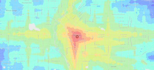
    I just came across an interesting web app created by geographer and programmer Andrew Hardin that maps public transit travel times for San Francisco, Seattle, Boulder and Denver.

    The app allows you to click on a location within one of these cities (or enter an address) and then receive a visual representation of travel times from that location.

    Both public transit and walking are factored in, and the fastest of the two is then modeled. The public transit data is taken from each respective authority and is similar to the data used by Google Maps.

    With these sorts of applications, I always wonder what it might look like overlaid with additional data points, such as home prices. Intuitively I would expect the best connected neighborhoods to also have some of the highest real estate values.

  • Poke the box, dammit

    Last night before bed I decided to buy a book on my Kindle (iPad app) that I’ve been meaning to read for awhile. It’s called Poke the Box and it’s by Seth Godin. It’s a short read and it’s meant to be that way. You could easily read it in one sitting.

    The book is about taking initiative. Taking action. And drawing your own map. It’s about not being scared of failure and realizing that failures are how you learn. It’s about poking the box, which is a computer programming reference. Programmers learn by poking the box (computer) and seeing what works and what doesn’t work.

    As I read through the book I’m reminded of something that venture capitalist Ben Horowitz wrote a few months ago on his blog:

    “Every employee in a company depends on the CEO to make fast, high quality decisions. Often any decision, even the wrong decision, is better than no decision.”

    Both Godin and Horowitz are, in a way, talking about the same thing: You have to keep moving. Make decisions. Start stuff. And stop worrying so much about being wrong, because it’s virtually impossible to know how things will eventually play out in the future.

    A perfect example of this is Starbucks.

    The first Starbucks in Seattle didn’t sell brewed coffee. It sold beans. And had it continued along this path, it certainly wouldn’t have become the brand that it is today. In fact, it may have failed completely. It wasn’t until Howard Schultz saw what they had started and combined it with what he had learned in Italy, that the Starbucks experience of today was born.

    The important thing is that somebody (Jerry Baldwin, Zev Siegl and Gordon Bowker) took the initiative to start and build a Starbucks. It didn’t matter that they got the recipe wrong, they poked the box and it ultimately lead to something magical.

    The same reluctance to poke the box can also be found in city building.

    Here in Toronto we spend a significant amount of time debating and vacillating around transit decisions (as well as many other things). Should we build LRT? Or should we build subway? What should we replace the Scarborough Rapid Transit line with?

    But we’ve fallen into analysis paralysis.

    The original Transit City Plan was announced on March 16th, 2007. It’s now 2014. And transit still sucks. Imagine if we started and finished, say, 2 kilometers of rapid transit each and every year. Forget worrying if it’s LRT, subway or a horse drawn space ship. We just kept moving.

    Something tells me that we’d be better off, even if we did make a few mistakes along the way.

  • Transit vehicle capacities compared

    I was cruising the twitter sphere yesterday when I came across the following chart, outlining the various transit vehicle capacities here in Toronto. It was created by Cameron MacLeod of #CodeRedTO, which is a grassroots group advocating for “a rational, affordable, and achievable rapid transit strategy for Toronto.”

    image

    On the left you have the vehicle type and then you have the capacity in terms of number of seats and standing room. The planned capacity is essentially the sum of those two numbers and the “unsafe crush load” is the number of people you could fit if you really put your back into it.

    Articulated buses refer to the longer (1.5x) bendy ones and, similarly, ALRV streetcars are the longer, articulated version of our regular streetcars. The low-floor streetcar is similar to what Toronto will be getting. And SRT is the Scarborough Rapid Transit system.

    The chart also compares between vehicle types: How many cars would you need to move the same number of people? How many buses? And so on. As one example, you would need 15.9 buses or 982 cars to move the same number of people as the Yonge subway line!

    What’s missing from the above chart though is light rail transit (LRT), which is comparable to the linking of up to 3 low-floor streetcars. In the case of the under construction Eglinton Crosstown LRT line, the planned capacity is 750 people!

    This is an hugely important takeaway because many people, including our own Mayor, do not properly distinguish between streetcar and light rail. The two are not one and the same. LRT has the potential to move a lot more people.

    In fact, at 750 people, the Eglinton Crosstown could move more people than the Sheppard subway line, which is only operating on 4 cars (as compared to 6 on our other subway lines).

    So while it’s all fine and dandy to bang our fists on the table and advocate for subways, they don’t make economic sense in all parts of our city. With the Sheppard line, we’ve been leaving capacity on the table and wasting taxpayer money.

    Of course this chart is also useful for those outside of Toronto. What I like about it is that it clearly shows the tool chest available to cities when it comes to building transit. Every city and neighborhood is different. And I think it’s important to have intelligent conversations about what makes sense in each.

    Thank you to Cameron and #CodeRedTO for allowing me to post their work.

  • Road pricing chicken and egg

    Regular readers of this blog will know that I’m a big supporter of road pricing. I think it’s an incredibly efficient way of reducing congestion, improving regional productivity, making us more sustainable, and funding other infrastructure, like transit.

    But one of the arguments I often hear against road pricing is that it’s unfair to force a segment of the market out of their car if there’s no good alternative (ie. proper transit). And even if the revenue produced from road pricing goes towards transit, we all know that new infrastructure takes a very, long, time.

    So we end up with a chicken and egg problem: Road pricing is a great way to fund transit, but it’s difficult to implement without the proper transit in place. So what should we do? What comes next?

    I have two thoughts.

    First, road pricing doesn’t necessarily mean that you can no longer drive without paying. Effective road pricing matches price with demand. Therefore if there’s nobody else on the road, you wouldn’t be paying (or at least wouldn’t be paying much). This is what makes it efficient—it adjusts. So for somebody without the willingness to pay for peak congestion pricing, they could still have the option of driving at another time. Go in early or go in later.

    But what it does mean is that no matter what time you’re driving, the road could be priced so that it actually functions again. In Toronto today, many of our roads are completely failing. Demand greatly exceeds available supply (the amount of road we have) and so you can’t use them to get anywhere in an efficient way. So what we have is equal access to terrible non-functioning roads.

    Second, there’s no such thing as a free lunch and nobody said it was going to be easy to build phenomenal infrastructure. We all complain and say we want it, but when push comes to shove, are you willing to open up your wallet and pay for it?

    So I say forget pontificating about chickens and eggs and just do it. If we priced roads and setup other appropriate revenue tools, I’m sure there are some financial wizards in this city that could use tax increment financing or other mechanisms to ensure that we get shovels in the ground today for the new infrastructure that we so desperately need.

    These are important discussions to be having no matter what city you live in. I would love to hear your thoughts in the comment section below or on twitter.

  • Right answer to the wrong question

    Yesterday I wrote a post on why Norway loves Tesla Motors. The lesson was that if you want people to adopt sustainability, just make it cheaper. But here’s something to ponder: Are electric vehicles the right answer to the wrong question? (Jeff Speck in Walkable City)

    Now, don’t get me wrong, I think electric vehicles are great. They’re certainly better than gas vehicles from a sustainability standpoint. But is the ideal city of the future one where everyone is driving around in electric vehicles? Or is it one where the majority of people walk, bike and take transit? It’ll likely be a mixture of both scenarios, but I think it’s important for cities to know where they want to go.

    Switching from gas to electric solves some problems, but it doesn’t solve all of them. Traffic congestion and lost productivity, for example, don’t go away. So I would say that electric vehicles are part of the right answer—but there’s still lots of other work to be done.

  • Car as prosthetic

    I spent a lot of time in the suburbs over the holidays and it got me thinking.

    For all the talk about intensification here in Toronto, adapting our car dependent suburbs to become, well, less car dependent is going to be an enormous challenge. Once you’ve built out an area around the car, it’s almost impossible to go back. 

    One of the biggest challenges is going to be figuring out how to turn the suburbs from inward to outward. If you think about it, the suburbs are an incredibly inward type of development pattern.

    Retail plazas typically have their entrances—not off main streets—but off internal parking lots. And residential areas often have backyards facing the main streets because nobody wants a house fronting on a major thoroughfare. These are the design principles we’ve used to create our suburbs.

    But the result is that we’ve created environments that are inhospitable to pedestrians. What enjoyment would you get out of walking along a street where everything has its back turned to you? This is the anthesis of animated street life. And in this case, Margaret Thatcher would probably be right: I would feel like a failure taking the bus.

    To compensate for this kind of environment, we’ve made it virtually mandatory to have a car. It’s the only reasonable way to get around. Writer Rebecca Solnit put it best when she said:

    “In a sense the car has become a prosthetic, and though prosthetics are usually for injured or missing limbs, the auto-prosthetic is for a conceptually impaired body or a body impaired by the creation of a world that is no longer human in scale.”

    And that’s precisely it. We built around the car and not around people. And in doing so, we made ourselves dependent. I don’t know about you, but there’s something liberating about being able to walk to all the things I commonly want—food, money, coffee and so on. But maybe that’s just me.

  • A question of infrastructure

    One of the main reasons why I hear people oppose certain development projects is because of a lack of infrastructure. Whether it’s roads, transit or something else, the concern is that what we have is inadequate to service what we’re about to build.

    Now, I understand that we can’t completely overburden the city, but I still have fundamental concerns with this line of thought. 

    The population of the Greater Toronto Area is expected to grow by 2.5 million people over the next 20 some years, to almost 9 million people by 2036. What this means is that growth is happening and it doesn’t really care whether or not we have the “right” infrastructure in place. It’s coming and we need to figure out how best to house these people while at the same time building the most livable and prosperous city on the planet.

    And I’m not sure most people appreciate that if we don’t build up (intensification) it means we’re going to be building out (sprawl). Again, the growth isn’t going to stop. And this represents an even greater strain on our region’s infrastructure (both built and natural) because it puts people into less intense land use and into cars.

    So what I’m going to suggest is that instead of asking if our current infrastructure will handle the future, we ask why the future hasn’t been built into our current infrastructure? It’s a question of being proactive, rather than reactive.

    We should be demanding better infrastructure instead of holding back progress because of our inability to properly city build. We should be demanding the best as opposed to knocking everything else down to the lowest common denominator.

    A perfect example of this is transit.

    I strongly believe that transit is one of, if not the, biggest issue facing our region today. Decades of disinvestment are really showing my friends. And if we don’t get our act together, the impact on our quality of life, our environment, and our economic productivity is only going to worsen.

    We need to be asking the right questions: Is the development the problem or is the real problem our infrastructure deficit?

  • Transit panel responds to Metrolinx

    On September 18th, 2013, the Premier of Ontario, Kathleen Wynne, established a “transit investment strategy advisory panel.” Their mandate was to advise the Province on how to respond to the revenue tools proposed by Metrolinx (also an Ontario agency) to fund transit expansion in the region. Well that panel has just released their final report and you can read it here.

    I’d like to highlight 3 things from the report.

    1.

    The first is their assessment of how Canada’s transit policy framework stacks up against our competitors. Here’s a snippet:

    “Canada remains the only G8 country without a coordinated national framework of policies and programs for funding expansion and renewal of transit systems. As shown in the chart opposite, a review of national transit policy frameworks done by the Canadian Urban Transit Association indicates that Canada ranks at the bottom in terms of its engagement in urban public transit.”

    And here’s the chart they’re talking about. I hope it’s legible.

    2.

    The second is their conclusion on highway tolls:

    “Although highway tolls can raise a significant amount of revenue and influence travel behaviour, they are expensive, complicated, and require a lot of lead time to implement. Once transit alternatives are in place, road tolls meet our criteria and are a valid option. Following the opening of the new Highway 407 East, the Province has the option of designating the new toll revenue to the Next Wave. For now, however, the Panel has not recommended Highway Tolls as a revenue source.”

    If you’ve read any of my posts on electronic road pricing, you’ll know that I support the pricing of roads and congestion.

    3.

    The third is their list of what they call “next wave projects”, which are essentially priority projects. Here’s their list for phase one of it:

    • Relief Line
    • GO Two-Way All Day (excluding Lakeshore)
    • Hurontario LRT
    • Electrification of Union-Pearson Express
    • Yonge North Subway (partial extension, delivered after Relief Line is in service)
    • Priority portions of other rapid transit – Hamilton, Durham, Dundas, Brampton

    I’m happy to see the relief subway line on the top of that list.

    If you have any thoughts on transit planning in the Greater Toronto Area, I would love to hear from you in the comment section below.