Daily insights for city builders, delivered every morning at 6 AM ET. I’m Brandon Donnelly — a Toronto-based real estate developer and founder of Globizen. I’ve been writing here since 2013.
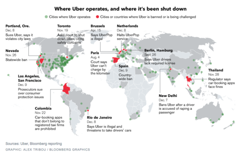
Earlier this month, Bloomberg published this map showing where Uber operates and where it’s been banned (or is being challenged). You can click on the map for a larger version.
Uber operates in about 250 cities across the world. But it’s being challenged in a lot of them, including Portland, San Francisco, Los Angeles, Toronto, Rio de Janeiro, Paris, Berlin, as well as others.
I don’t want to dismiss any of the safety concerns that have arisen lately, because those are very serious and they need to be addressed. Life safety is paramount. But I continue to believe that banning a service that many people clearly want to use isn’t the right solution.
On top of that, I think it could lull many of the local taxi communities into a false sense of security about the future. Uber is moving incredibly quickly. UberX launched in Toronto in September of this year. And UberPOOL – their new carpool service – is likely next.
With these releases, Uber is working towards a specific vision for the future: Their goal is to eliminate the need for private vehicle ownership. Should they be successful, this will not only impact taxis, but also car manufacturers and urban mobility in its entirety.
So as difficult as it might seem right now, I think urban leaders would be better served trying to figure out how to harness these innovations. Cities have been trying for decades to get people out of their cars. Uber wants to do the same.
It was built to correct what had become a major slum on the east side of downtown Toronto. And like many cities around the world, this type of built form was viewed as the solution. Urban slums were crowded and dirty. Density was bad. The solution was to spread people out and surround them with green space.
But that didn’t work out so well. Regent Park failed. So today we are once again starting again. Phase by phase, the old is being demolished and the new is being built. However, unlike the last time, I think this time it’ll be for the better.
But there’s something very ironic about this story.
Before Regent Park became Regent Park, it was called something else: Cabbagetown. That neighborhood of course still exists in Toronto – it’s adjacent to Regent Park – but it’s now a bit smaller having given up a portion of its land to the first iteration of Regent Park.
Today, what remains of Cabbagetown has become an affluent and desirable inner city neighborhood with, allegedly, the largest stock of Victorian housing in North America. But of course it wasn’t always that way. At the time that Regent Park was being conceived, Cabbagetown was a slum. And that’s why we built Regent Park version 1.0. It was the solution for this entire section of the city.
The photo at the top of this post is the southeast corner of Gerrard Street East and Parliament Street. The building at the corner is the Hotel Gerrard. The photo is from 1919, which means it’s a photo of Regent Park when it was still called Cabbagetown. It’s part of what we demolished to make way for the new.
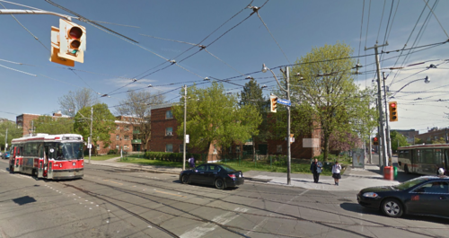
In 2013, that same corner looked like this:
What’s ironic about all of this, is that the area we spared from grandiose urban renewal plans actually became the richest part. And where we intervened is where things got screwed up. So much so that we’re now starting entirely from scratch, again. All of this just makes wonder whether Cabbagetown, in its entirety, would have ultimately taken care of itself had we just left it alone.
But what’s in the past is in the past.
So to end on a positive note, I’d like to share a short video that somebody recently shared with me called Spectrum of Hope. It was co-directed by 7 young artists from the neighborhood who are calling it “a piece for Regent Park, by Regent Park.”
I think it’s a great example of the positive momentum developing in this neighborhood. I hope you’ll give it a watch and then share it around. Click here if you can’t see the video above.
Today is Christmas Day. I hope that you are all having a wonderful day and spending it with family and friends. That is exactly what I’m doing here in Toronto.
It’s certainly nice to have a bit of downtime. I’ve been playing around with my new GoPro (see above photo), which had been sitting unopened on my shelf for the past few weeks.
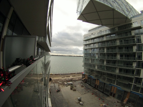
The photo above was taken at the Pier 27 condos. It’s still very much a construction zone. The area at grade in the photo will be a linear public park that connects the main street to the waterfront. I’m looking forward to seeing it come together.
Here’s a snippet that summarizes the things he believes we should be doing:
Municipalities across Ontario also have significant tools at their disposal to make a difference. To date, these tools have not been co-ordinated to achieve maximum bang for the buck. Property taxes can and should be waived not only for affordable rental homes but for affordable ownership homes as well. Additionally, cities can and should waive all development levies and other municipal fees for affordable rental and ownership housing.
Combined, these two measures provide municipalities with powerful leverage to implement inclusionary zoning — the most important tool in the affordable housing tool box. Inclusionary zoning on a city-wide basis creates a level playing field, an opportunity for a constructive partnership between municipalities and private sector developers to create both affordable ownership and rental homes within every new building approved for construction.
For those of you who might be unfamiliar with inclusionary zoning, it’s essentially a zoning requirement to build a certain number of affordable units in any new construction project. It originated – as far as I know – in the US, but has been fairly controversial since the outset.
So today I thought we could have a discussion on the merits of inclusionary zoning. Do you think it’s a good or bad thing for cities? Is it really the most effective way to deliver affordable housing at scale? Leave your thoughts in the comment section below 🙂
I don’t have a strong view on inclusionary zoning, but I do believe that affordable housing and a mix of incomes is critical to cities and neighborhoods.
I do, however, wonder if it’s one of those things that seems to make a lot of sense, but actually has a bunch of negative externalities associated with it. Maybe the answer is to just prototype the idea and then iterate on it.
Yesterday morning I had coffee with a good friend of mine and fellow city geek. We don’t connect nearly as often as I’d like, but when we do we always have great conversations about cities and about Toronto.
One of the things he asked me was whether I was still loving Toronto. And I responded by saying absolutely. We then both agreed that there are a lot of exciting things happening in the city right now.
But I qualified this statement by saying that I wish we were bolder. I wish we took more chances. Because while it’s great that we’re doing things like building more bike lanes and intensifying our growth centers, lots of other cities are doing those things as well.
By 2020, no diesel fuel at all will be burnt within Paris. Regular cars will be banned outright from its more polluted roads, which will be open solely to electric and hybrid vehicles. Meanwhile, the city’s most central districts (the first four arrondissements) will be barred to all but residents’ vehicles, deliveries, and emergency services, transforming Paris’ Right Bank core into a semi-pedestrian zone. As a counterbalance, the number of cycle lanes will be doubled by 2020, while the city will fund an extended electric bikeshare scheme to encourage more people to get on two wheels. “I want us to be exemplary” Mayor Hidalgo has declared.
That’s how you win hearts: by being exemplary.
As always though, I’m incredibly optimistic about the future. Toronto has a new leader at its helm and I know that there are a lot of passionate people in this city who care deeply about its future. I am certainly one of them.
A few days ago I wrote a post talking about what happens when you demolish an urban highway. It was a link to an article giving 5 examples of cities that have removed their urban highways and benefited.
After I wrote the post, a number of people responded on Twitter. Some thought it was a great idea and gave examples of other cities, such as Detroit, that are thinking about doing the same. But others responded and said that I was out of line. And that while it might work in some cities, it simply isn’t a viable option in cities like Toronto.
So as somebody who believes we should be taking down the Gardiner Expressway, I thought it would be worthwhile to revisit the topic and provide a bit more information.
To be clear, I’m not suggesting we remove the Gardiner and replace it with nothing. My belief is that we should replace it with a broad surface street that would still move lots of cars, but that would make our waterfront much more open and accessible to everyone.
So how is this feasible?
Again it comes back to the concept of induced demand. Back in 2009, two economists from the University of Toronto and University of Pennsylvania – which are actually both of my alma maters – published a study called The Fundamental Law of Road Congestion.
In it they discovered something really fascinating: there’s a near perfect relationship between new roads and highways built and the total number of miles driven. In other words, as cities increased road capacities (during their study period of 1980 to 2000), the amount of driving went up just as much.
What this should tell you is that trying to build your way of out road congestion is usually a losing proposition. That’s why every large city has a traffic problem. Try and think of one that has solved this. And as much as it might seem intuitive to tell people at cocktail parties that your city simply needs to build more roads and highways, it’s typically not that simple. (In my view, the solution is road pricing.)
The other really interesting thing that this study revealed is that it works both ways. When you reduce road capacity, drivers start to disappear. People choose to live closer to where they work. People choose transit. People go into the office at different times. People make all sorts of different decisions in response to this road change, just as they do when there are more free roads available to them.
So within a reasonable band (obviously you can’t remove all roads), there is no perfect amount of road capacity. If you added another lane to your highway, it would be full. If you took away a lane, it would end up equally full. That’s why removing the Gardiner Expressway isn’t lunacy.
Instead, it actually makes a lot of sense:
It’s the cheapest solution (compared to repairing it or burying it)
It would free up money for transit and other mobility solutions
It would make our waterfront more open and accessible
It would beautify our downtown
It would increase land values all along the waterfront
And since we’re still in the early days of developing our eastern waterfront, now is the time to do it. The longer we wait, the harder it’ll get and the more expensive it’ll get.
So I hope that the leaders in this city will think long and hard about this as opposed to immediately assuming we need an elevated highway to keep this city moving. The last time I checked, it doesn’t work so well in its current state.
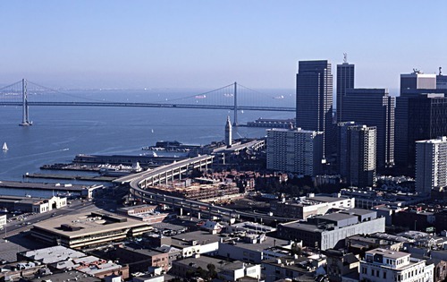
Images: Before and After the Embarcadero Freeway in San Francisco (via Gizmodo)
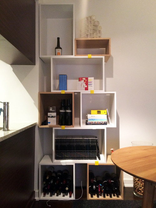
I don’t have a lot to say today. I had a busy day and then this evening I set up some new shelving in my apartment. Here’s what it looks like:
There’s a bulkhead directly above it (that you can’t see in this picture) and so I’ve been wanting to put shelving in this corner ever since I moved in almost 2 years ago. I haven’t really organized the contents yet, but I did get some wine into the bottom of it. First things first.
Initially I thought about getting built-in shelves. But custom millwork is expensive and, to do something even remotely interesting, the pricing got stupid. So I searched and searched and eventually stumbled upon the Muuto stacked shelf system designed by JDS Architects.
This is the picture that sold me:
My setup doesn’t look nearly as impressive, but I’m still thrilled with it.
The way it works is really simple. You stack up the boxes however you would like and then, once you’re satisfied, you just clip them together. That’s what those yellow things are in my picture. You can hide them at the back if you want, but I purposely ordered yellow ones in order to highlight how the system actually goes together.
It wasn’t the cheapest option out there, but I’d rather have fewer things of higher quality. I already have too many things.
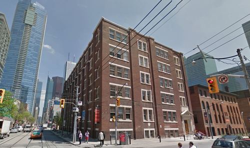
The property sits at the southeast corner of Adelaide Street West and Duncan Street (shown above), and includes an existing 61,911 square foot (GLA) office building, 36 surface parking spots, and a laneway (it was specifically called out in the press release).
The plan is to restore the existing heritage building, as well as build additional retail space, office space, and rental apartments. Given the nature of this site and the team behind it, I have high hopes that it will end up a remarkable development project.
It’s interesting to see the continuing interest in rental apartments here in Toronto – which is something I’ve written about before. Up until recently, the development community had almost zero interest in purpose built rental apartment buildings. Now they’re coming back in fashion.
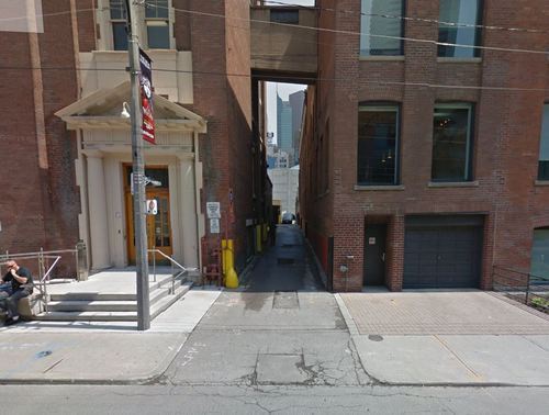
But the other piece that’s interesting to me is the laneway. Below is a photo from Google streetview, showing what I believe is the laneway that the press release is referring to.
As many of you know, I’m involved in a non-profit here in Toronto called The Laneway Project (advisory role only). We want to transform Toronto’s underutilized laneways. And this strikes me as a perfect opportunity to do something really exciting at the corner of Adelaide and Duncan in the Entertainment District.
So if the new owners have any interest in things that are exciting, I would encourage them to get in touch with me or one of the founders of The Laneway Project.
This past week was Toronto’s first real snowstorm of the season. It was awesome. I love snow. And part of the reason I love it, is because it means snowboarding season is here. Yes, the “mountains” in Ontario suck, but Quebec and Vermont aren’t too far away and every February there is The Annual.
This year in preparation for the season I decided to splurge on a GoPro camera. We had a lot of fun filming last year in Jackson Hole and, since it looks like we’re going to have close to 10 people at this season’s Annual, I wanted to throw another camera into the mix. Expect another ski and snowboard video sometime in February 2015. We’re heading out to Alberta and British Columbia.
I also ordered this mount for the camera:
But as I was ordering the camera, I started to think about what else I could use it for. And then it hit me: city tours. One of the things I love to do in the summer is ride my bike around the city and explore. I like to find areas I don’t know very well, find new developments I may have missed, and generally just get to know the city more intimately.
Being on a bike is really the perfect way to do this. You don’t cover enough ground walking and with driving you simply miss too much of the city. So what I want to do is strap my GoPro to my handle bars and bring you along for these exploratory bike tours. I think it could be a unique way to show you the city – even if you happen to also be from here.
How does that sound?
It likely won’t happen until the spring, but if you’re interested in joining me, let me know. I think this could be a lot of fun with a group of city geeks.
The Economist recently published an essay called, A Planet of Suburbs – The world is becoming ever more suburban, and the better for it. The argument is basically that the “great urbanization” that everyone loves to talk about these days is actually a misnomer. From Chicago to Chennai, it’s not the urban core that’s growing. It’s the suburbs. And so what we’re seeing should actually be called the great suburbanization.
The basis for this argument is that wealth fuels sprawl. As people become richer, they naturally consume more of everything – including space. It’s a natural market outcome.
Take for example, the path of many of Toronto’s ethnic groups. In the first half of the 20th century, College Street was the Little Italy. Then it shifted north and St. Clair Avenue West became the more authentic Little Italy. Today, many Italians now live north of the city in Woodbridge. In fact, last weekend I was on St. Clair West and was disappointed to learn that one of my favorite butchers had closed up shop and “moved to Woodbridge.”
However, there are also many supporters of the exact opposite outcome. From Edward Glaeser to Alan Ehrenhalt, many have argued that we’re in the midst of a “great inversion.” The suburbs are no longer a threat to urban centers. It’s the urban centers who are threatening the suburbs. The suburbs are dead. Long live the city.
So which is it?
Well, The Economist does cite two examples where true urbanization is actually taking place. It’s happening in Tokyo and London. In both cases, it’s the city center that is growing the fastest – not the suburbs. The explanation for Tokyo is its aging population. And the explanation for London is its restrictive greenbelt, which effectively stops the possibility of any further sprawl.
Here in Toronto – where there is also a greenbelt in place – we know that the population of the downtown core is growing at an incredible pace. A recent report by the city – called Comprehensive to the Core – revealed that the downtown core is growing at 4 times the rate of the rest of the city.
But what about the suburbs?
If we look at the province of Ontario’s growth projections, it is indeed the suburbs which are expected to grow the fastest up until 2036. Here is a diagram showing percentage growth rates:
In absolute numbers, the city of Toronto alone is expected to add about 0.66 million people between 2012 and 2036, and the suburbs are expected to add almost 1.9 million.
There are a number of potential explanations for this differential, but I think it’s largely because land is cheaper in the suburbs, it’s easier to add new housing supply, population densities are lower, and we’re talking about very different land areas.
The city of Toronto is 630 square kilometers. If you tack on the suburbs, the Greater Toronto Area is 7,124 square kilometers. That means Toronto makes up less than 9% of the total land area. And yet it is expected to contribute 25% of the region’s population growth.
Still, the suburbs are where the bulk of the population growth is expected to happen over the coming decades.
However, the “great inversion” that authors like Alan Ehrenhalt have been talking about should not really be interpreted as the death of the suburbs. What he’s instead talking about is a socioeconomic or demographic reversal: center cities used to be poor and now they’re becoming rich.
What we are seeing is a reversal in which the words “inner city,” which a generation ago connoted poverty and slums, [are going to mean] the home of wealthier people and people who have a choice about where they live, and the suburbs are going to be the home of immigrants and poorer people. And Census figures show that that’s taking place.
In this context, we are still living through the great urbanization. We’re seeing a shift in consumer preference and a shift in where wealth is choosing to locate. That’s a profound change.
And while we’re obviously still suburbanizing, I don’t agree that we’re better for it. In fact, left unchecked, this demographic inversion could actually prove to be quite damaging to our suburbs.