Daily insights for city builders, delivered every morning at 6 AM ET. I’m Brandon Donnelly — a Toronto-based real estate developer and founder of Globizen. I’ve been writing here since 2013.

Tag: toronto

  • #DensityCreep

    The Toronto Star published an article today called: Midtowners battle the rise of the midrise. It’s about a group called The Density Creep Neighborhood Alliance, which was formed in order to fight a 4 storey stacked townhouse project that is currently going through the rezoning process.

    Here’s a snippet from the article:

    “I’m really concerned about my property value going down,” says Lisa Goodwin, 49, a stay-at-home mother of two who has lived in a four-bedroom dwelling on Keewatin Ave. for 19 years. “Right now all the houses are $1.1 to, say, $2.2 (million) but they’re looking at putting in places that are only $500,000.”

    Not surprisingly, social media took hold of this and #DensityCreep quickly started trending on Twitter. BuzzFeed ran a piece called, Toronto Real Estate Is So Preposterous People Are Protesting Condos That “Only” Cost $500K. And somebody even bought densitycreep.com (their site is .ca) and redirected it to NIMBY on Wikipedia.

    There’s so much I could say about this. But you all already know what I’m thinking. So I’ll end with this quote from the article:

    “The simple fact of the matter is that the creation of a more sustainable, equitable, and affordable city requires the development of midrise and other more dense housing options along major roads, subways, and streetcar lines in already built up areas,” says Christopher De Sousa, director of the School of Urban Planning and Regional Planning at Ryerson University.

    We have work to do.

  • Walking the West Side Highway

    image

    I am in New York this weekend. Every now and then I need to get my fix of this city. I just love it here.

    Given the debate that’s going on in Toronto right now about the elevated Gardiner Expressway, one of the things I wanted to do this weekend was walk the West Side Highway. The West Side Highway runs along the western edge of Manhattan from 72nd Street all the way down to the southern tip of the island. It used to be an elevated highway, but it runs mostly at grade now.

    I’ve been to and on it many times before, but I wanted revisit it with a different lens. Many people in Toronto seem to think that if we remove the Gardiner East and replace it with an enlarged Lake Shore Blvd that it would pose just as much of a physical barrier as an elevated structure.

    So I walked the West Side Highway and filmed this (Hyperlapse) video:

    //platform.twitter.com/widgets.js

    I think it’s a big improvement over an elevated structure. What do you think?

    There is, however, an elevated highway uptown. So tomorrow I plan to travel it on a scooter that I’ve rented to see how the urban fabric changes around it. I suspect it’ll be quite different.

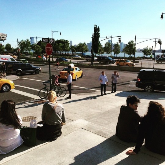
    In case you were wondering, the picture at the top of this post is from the steps at the Whitney Museum. They face the West Side Highway and the water. It’s a great public space, but I’m pretty sure that Renzo Piano wouldn’t have designed it that way (and with that orientation) had there been an elevated highway in front of it.

  • 4 design strategies for your cold-climate waterfront

    Photograph Sugar Beach in Toronto by christophmarten on 500px

    Sugar Beach in Toronto by christophmarten on 500px

    Since we’ve been discussing waterfronts lately, I thought I would share this post from ArchDaily talking about 4 ways that cold-climate cities can make the most of their waterfronts.

    They are:

    1. Plan for winter sun
    2. Create plazas that block wind
    3. Break up outdoor spaces with comfort stations (not sure why they just have to be stations)
    4. Design for active winter programming

    These, of course, aren’t new design strategies. Cities have been built around their climates since, probably, the beginning of cities. It wasn’t until more recently that we started basically ignoring local climates and focusing more on what mechanical systems can do to make us feel comfortable.

    But I think that was a mistake. I don’t think that mechanical systems are bad though. I just think that there’s a lot that we can do first – without mechanical systems – to address local climates.

    If you’ve ever sat on a patio during a swing season (i.e. right now) where the wind was blocked and you were in the direct sun, you already know that there’s a lot that can be done without relying on active systems.

    But the other thing I like about this post is that it acknowledges the fact that winter waterfronts require just as much, if not more, design attention than a warm-climate waterfront.

    Saying that we’ll (insert cold-climate city name here) never be Miami or Barcelona or Sydney is just giving up.

  • A petition to Toronto City Council to remove the Gardiner Expressway East

    image

    “If the decision ultimately of the council is to support the hybrid I think frankly it’ll be a major step backwards and you’re going to miss a once in a lifetime opportunity, and I’ll be very frank, we’ll be the laughingstock of the world.” 

    -Paul Bedford, former chief planner of Toronto

    As many of you I’m sure know, I have been a vocal and passionate supporter of removing the eastern portion of the elevated Gardiner Expressway in downtown Toronto. I have written about it so many times that a lot of you are probably sick of hearing about it.

    I’m sorry if that’s the case. But it’s a hot and important topic in Toronto right now. We’re just over 3 weeks away from City Council finally making a decision. That is scheduled to happen on June 9th and/or 10th. 

    For the most part though, I was pretty confident that we would ultimately make what many of us believe is the right decision. But then this past week Mayor John Tory went public in his support for the “hybrid” option, which is basically to rebuild the elevated expressway in a slightly different configuration. And that really upset me.

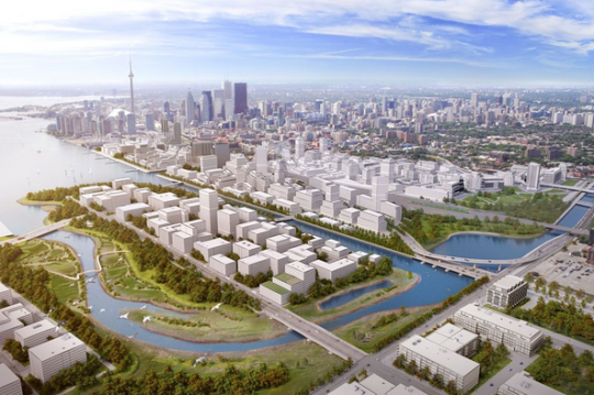
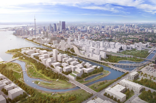
    Here’s what that looks like (versus the remove option shown at the top of this post):

    image

    Have we learned nothing from our past city building mistakes?

    Since that announcement, I went on Twitter every night this week to check out the discussions that were happening around #GardinerEast. And every night it got me so worked up that I then had trouble falling asleep. I have since stopped reading about the Gardiner East before bed.

    But rather than just get frustrated, my friend (a fellow city builder named Stephen Job) and I decided to do something about it and create a petition using Change.org.

    It is a petition that we will ultimately be sending to Toronto’s entire City Council prior to their June 9 meeting and we hope that you will consider signing it and sharing it with your network – regardless of whether or not you happen to live in Toronto. (Although it’ll certainly help if you’re a taxpayer and voter in the City of Toronto.)

    We just finished getting it up and you can check it out and sign it by clicking here.

    Images: Toronto Star

  • When the crowd builds a city

    I’ve been following and checking out Kickstarter pretty much since the beginning. But it wasn’t until last night that I backed my first project. 

    After doing that, I immediately started thinking about urban projects that might be able to also get crowdfunded using Kickstarter. How could it be used for city building? A Kickstarter project, after all, just has to be something with a defined scope and a clear end goal.

    Not surprisingly, this has already been happening for many years now.

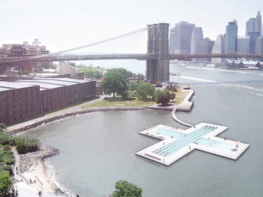
    A great example is +Pool in New York, which is an initiative to build a publicly accessible floating pool that also filters river water. The project launched in June 2011 and by July 2011 they had raised $41,648 USD to build and test different filtration techniques.

    image

    Today, the project is still moving ahead and they are now offering up the opportunity to buy and have your name engraved on tiles within the pool. If I lived in New York, I would be all over this.

    But what’s powerful here is the ability for crowd-based platforms (like Kickstarter) to both get radical new ideas off the ground and to empower local communities to affect change. Here’s a quote from PSFK:

    It’s very difficult to get funding for these ‘out there’ ideas that regular systems might not support. Creators have to take risks and be imaginative, as well as put their ideas out there and let the public decide. There are no traditional guidelines on crowd-sourced platforms—they’re much more meritocratic. You can think in big scope and that changes what gets made and who can access it. Anybody with a couple of doubles can voice what they want to be built, and in that way we see the entire community having a huge say in the design world.

    And when I see projects and platforms like this, I can’t help but wonder if (when) city building is going to become even more decentralized. 

    Last night I was also at an event – being put on by Ryerson University’s City Building Institute – called Bridging Divides: What Can Cities Do? And one of the suggestions that came up was that Toronto needs more local and granular community councils (there are currently 4) in order to bridge some of the divides that are happening in our city.

    But in a world where it’s possible for each and every person in a city to not only have a say but to quickly say it from their smartphones, why can’t we go even more local? Instead of 4, 10, or 90 community councils, why can’t we have everyone more engaged?

    I think we’re headed in that direction.

  • The infrastructure sandwich

    Today I came across the following tweet by Brad Tabke. (Brad is the mayor of Shakopee, Minnesota.)

    //platform.twitter.com/widgets.js

    On the left of the image is downtown Memphis. On the right is the Mississippi River. And in the middle is, well, a bunch of elevated highways. 

    It’s a powerful image regardless of where you happen to be from. But if you’re from Toronto, you might know why I’m posting it today.

  • Red stripes, iceberg homes, and laneway houses

    This morning I was reading a CityLab article talking about a homeowner in London’s wealthy Kensington neighborhood who painted her house in red stripes after the city and her neighbors derailed her renovation plans. I’m thinking it is supposed to be symbolic of government “red tape.”

    She had hoped to add a two-floor “mega-basement” to her home, which is curiously enough a thing in London due to how restrictive traditional home expansions can be. Locally they are called “iceberg homes.”

    What’s interesting about this phenomenon is that it shows you how far people will go to find and/or create the space they want in the neighborhoods they want to live in. Kensington is an incredibly wealthy area and so one has to assume that she is not without other housing options.

    As another example, here’s how the article describes her house:

    The candy-striped home in question, for example, is actually a mews house, a kind of outbuilding running along an alley behind a great house, originally intended as a place to tidy horses, carriages and maids away from the main residence.

    So not only did she want to create an “iceberg home”, but she wanted to do so in what was previously a back alley. In Toronto, this home would be called a laneway house.

    What this tells me is that as real estate values rise, people will naturally start to seek out overlooked spaces to repurpose. They will look for some way to carve out a home. And it’s for that reason that I think laneway housing is an inevitable outcome here in Toronto.

  • Name your laneway

    Photograph Urban Explorer by Andrew B. on 500px

    Urban Explorer by Andrew B. on 500px

    Laneway housing is becoming an incredibly popular topic here in Toronto. Lots of people seem to be interested in building, or least living in a compact ground-related laneway dwelling. 

    A big part of this, I think, has to do with affordability (or the perception of affordability). A lot of people want to live in a central urban neighborhood, but it has simply gotten both expensive and difficult to secure low-rise housing. Here’s an example of a young couple in Toronto who went door-to-door in their desperation to find a house.

    I believe that laneway housing has the potential to be a more affordable low-rise housing solution in this city, as well as in many other cities around the world who have a similar urban condition. But today, at least here, it’s not that way.

    Since the City of Toronto does not officially support laneway housing, it would be an uphill to get one approved and you need to be willing to put a significant amount of money at-risk in order to try. It’s unfortunate, but that’s the reality today.

    I’m certain that will change. But it will take a bit more pioneering. The Laneway Project, which I advise, is working to change the way Toronto thinks about its laneways and I know that there are many other small entrepreneurs working on doing the same.

    One of the first things that will need to happen is that we’re going to need to name our laneways. Some of them are already named, but many of them are not. And while this may not seem like a big deal, it is. For laneway housing to become a reality, they will need to have addresses and we will need to think of our laneways as legitimate streets.

    Recently The Laneway Project published a how-to guide called: How to Name Your Laneway. So if you’re interested in laneways and laneway housing here in Toronto, I would encourage you to give it a read and then try and get your local laneway named.

  • The unfinished city

    https://500px.com/embed.js

    Earlier this week I attended a talk at the University of Toronto called Data Innovation and City Governance. It was by Mark Kleinman who is from London, but is now a Visiting Scholar at the Munk School of Global Affairs.

    The topics covered would have been familiar to anyone who is a regular reader of this blog (the power of open data, the knowledge economy, etc…), so I’m not going to repeat it all here. But I did want to touch on one of his impressions of Toronto, which is that this is a city that is “never finished.”

    What does that mean?

    The opposite of a city that is never finished would be a city like Paris that feels a bit like a monument that is now done and shouldn’t be touched anymore. It’s a city that almost feels too precious to intervene in. This is obviously not the case for all of Paris, but I think you get the point.

    Toronto, on the other hand, is a city that is constantly building, changing, and renewing itself. There are often layers upon layers of new interventions being applied, which gives you the impression that the city will never be done. It’s constantly in flux.

    Some of you may not appreciate this kind of “messy” urbanism, but I think it gives cities a kind of entrepreneurial resiliency (resiliency is a hot topic right now in urbanist circles). Cities are an ecological system. And the most resilient ecological systems in the world are the ones that are able to adapt to constant change.

    So in my view I look at this as a feature, not a bug. The only constant is change.

  • Driverless cars, urban mobility, and Toronto’s Gardiner Expressway

    image

    About a week ago I wrote a post questioning what driverless cars will mean for cities. I ended by saying that that it feels as if we’re going to see increasing tension between private and public transport.

    What I meant by that was simply that conventional notions around private car use are going to change. And ultimately that is going to mean that we need to rethink public transport and how that fits into a broader urban mobility framework.

    What do I mean by this?

    The International Transport Forum at the OECD recently published a fascinating report called, Urban Mobility System Upgrade: How shared self-driving cars could change city traffic. And it deals with exactly the sorts of things I am thinking about.

    The study looked of what might happen when all cars become self-driving in a mid-sized European city (specifically Lisbon, Portugal). They leveraged existing transportation data from the city, but replaced 100% of the human powered cars with two types of self-driving cars: TaxiBots and AutoVots.

    TaxiBots were driverless cars that would be shared with multiple people at the same time. In other words, they were a kind of pseudo-public transit. And AutoVots we’re your more conventional private taxi. They picked up one person at a time.

    So, what did they find?

    In the first scenario, they combined their TaxiBots and AutoVots with public transit (light rail) and discovered that the same number of people could be moved around with only 10% of the cars currently on the road. That’s a 90% reduction!

    They also found that the city needed 20% less on-street parking and 80% less off-street parking since driverless cars don’t need to sit idle waiting for a driver.

    In the second scenario, they removed mass transit from the equation. And in this instance they found that the city was still able to get around, but with an 80% reduction in the number of cars on the road. Remarkably, it also led to a 10% reduction in rush hour commute times.

    These are pretty profound changes. Reducing the number of cars on the road by 80-90% is a significant change. 

    But it’s also why I’ve been thinking about the tension between private and public transport. As we get better at optimizing “cars” (their definition will change), what becomes the role of true public transit?

    Ultimately, I think what will happen is a blurring of the two. In the example above, the TaxiBots served basically as small scale public transit. But that does not necessarily mean that true mass transit will become irrelevant. We’re just going to need to rethink how the entire mobility network fits together.

    I’d now like to bring this discussion back to Toronto for a minute.

    As many of you probably know from this blog, Toronto is on the cusp of deciding what to do with the eastern portion of the Gardiner Expressway (an elevated highway that runs across the downtown waterfront). It will go to City Council next month. 

    I firmly believe that we should remove it, but there many people who believe we shouldn’t. The main objection seems to be that the traffic projections indicate that removing it could make commuting into downtown – by car – 3 to 5 minutes longer by 2031. 

    By today’s standards, I believe this concern represents an outdated way of thinking about cities and urban mobility. Adding more lanes is like loosening your belt to deal with obesity. However, it gets even worse when you think about urban mobility in the context of this post.

    Given the profound transportation changes that are currently underway, I think there’s a strong likelihood that the Gardiner projections we have today will be completely wrong by 2031. I don’t know know for sure, but I’m guessing the models don’t account for the efficiencies being created by driverless cars and peer-to-peer networks.

    In other words, I am suggesting that those 3 to 5 minutes could prove to be a red herring. The relevant question should be: Which decision will allow Toronto to build the absolute best waterfront in the world? And in my opinion that leads to removing the Gardiner East.

    If you feel similarly, I would encourage you to write your local City Councillor.