Daily insights for city builders, delivered every morning at 6 AM ET. I’m Brandon Donnelly — a Toronto-based real estate developer and founder of Globizen. I’ve been writing here since 2013.

Tag: toronto

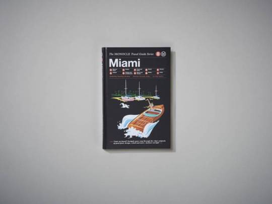
  • The Monocle Travel Guide Series — Miami

    I’m off this week to South Florida to check out Art Basel (among other things). This week isn’t a great week to be leaving the city since it’s the Toronto Real Estate Forum and lots of people are coming to the city for that. But I’ve wanted to go to Art Basel for over a decade, so it was about time I did that.

    I also decided to pick up the new Monocle Travel Guide to Miami. This is the 8th city that they’ve covered and, as you might know from reading this blog, I’m a big fan of Monocle. (I’m still waiting for the Toronto edition, guys.)

    As part of this guide launch – which was timed to coincide with Art Basel Miami Beach – they also released a short video that is worth watching.

    When most people think of Miami they probably think of sun and flash. And that is certainly part of the DNA of the city. But Miami has also grown into a global city with important and extensive connections to Latin America. It’s also an incredible place for those who love art, architecture, and design. If you watch the Monocle video, I’m sure you’ll feel that. 

    Miami is absolutely one of my favorite cities.

  • 3 real estate + tech startups

    image

    On Thursday night I spoke at Product Hunt Toronto about the overlap between real estate and tech. My slide deck will be made available online and I’ll be sure to tweet it out and link to it in the comment section of this post.

    What was amazing to see was a room filled with 250 people coming together from almost two different worlds. I’m generalizing here, but you had the real estate people in suits and the tech people in t-shirts. But they were all mixing together to figure out how technology is going to disrupt the real estate industry. That is great to see.

    This was not the case 5+ years ago when I started obsessing about the overlap between these two spaces. I remember pitching at a Startup Weekend here in Toronto where I was pegged as the fringe outlier for wanting to work on a real estate idea. Now I can’t keep track of all the startups who are tackling this space.

    But this is a trend that is happening not only in real estate but in almost every other vertical. Here’s a quote from Fred Wilson that I used last night:

    “One of NYC’s great strengths is the diversity of its economy – finance, real estate, media & entertainment, retail, fashion, health care, education, and now tech. And the reason tech is growing so fast in NYC is that it is embedding itself in all of these other industries.”

    It’s an exciting time.

    In any event, for those of you weren’t able to attend, the 3 startups that presented were Evercondo, PiinPoint, and MappedIn.

    Evercondo is a condo communication and management tool for property managers and boards. PiinPoint is a data-driven tool that helps businesses find the best places to locate within a city. And MappedIn creates digital wayfinding solutions for (primarily) retail stores and venues.

    If you know of any other interesting startups tackling the real estate space, please share them in the comment section below. Early stage companies need all the support and exposure they can get.

  • But what about employment?

    The Neptis Foundation here in Toronto just recently published a fantastic report looking at the regional economic structure of the Greater Golden Horseshoe area. It’s called Planning for Prosperity.

    In it they identity the polycentric nature of employment in the Toronto region by way of downtown Toronto and three suburban “megazones.” Here’s one of their maps showing overall employment density and the megazones (light blue circles):

    Here’s a snippet to give you an idea of the scale of these megazones:

    “The Airport megazone, one of the three employment megazones outside Downtown Toronto, is the second largest concentration of employment in Canada, after Downtown Toronto. It represents almost 300,000 jobs, more than the central business districts of Montreal, Vancouver, or Calgary individually.”

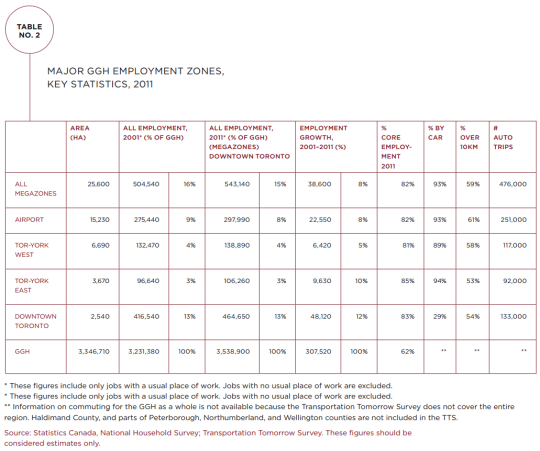
    And here’s a chart showing the hard numbers:

    Downtown Toronto dominates in terms of employment. But it’s also fascinating to see how much more efficiently it provides that employment. It has the smallest physical area of all the employment zones (2,540 hectares or 6,276 acres) and the lowest percentage of car trips (29%).

    But the big takeaway from their report is that we have not been focused enough on employment in our planning. Instead, we seem to be thinking residentially. Here’s a final snippet:


    “This study shows that the Growth Plan and The Big Move, which are currently under review, do not address the challenges and opportunities of a globalizing regional economy or the reality of a transforming economic landscape.

    The Growth Plan’s focus has largely been on managing residential growth rather than non-residential and employment-related development. Indeed, the Growth Plan is based on shockingly little hard evidence on the evolving economy of the region. Plans for city-regions a fraction of the size of the GGH typically involve more economic research, analysis, and evidence.”

    Clearly we need to be looking at both the residential and non-residential sides of the equation as we grow the region. To read the full report, click here.

  • Housing completions in Toronto from 1996 to 2014

    Whenever I read studies that cite census data, I’m often left feeling like the data is out-of-date. 

    Five years – which is how often Canada conducts its national census – is a long time. Somebody could move to this country for school, complete a 4-year degree, and then leave, and we wouldn’t even pick it up in our data.

    Thankfully, we’ve at least reinstated the long-form census for next year. Here are the questions, if you’re curious.

    But all of this is a digression. 

    This morning I read through a housing report that the City of Toronto published in October of this year. It’s about housing trends. And I wanted to share the below chart that covers housing completions for the period of 1996 to 2014. Keep in mind that this is for the City of Toronto, and not the Greater Toronto Area.

    What it shows is that over this 18 year period, 78% of all housing completions in this city have been either low-rise or high-rise condominiums/apartments. The remaining 22% is a mix of detached and semi-detached houses and townhouses.

    However, this 22% is an average. 

    Detached and semi-detached housing completions declined from 22% in the 1996-2001 period to 10% a decade later. And row and townhouses declined from 16% to 6% during this same period.

    At the same time, “many” of the housing units in this 22% were actually replacing existing and older housing stock. That is, according to the report, many were “knock-downs” and rebuilds. In these cases, it means that the completions actually do not represent net new housing units. So in reality, the supply of new single-family housing is even lower than it appears in the chart above.

    When you look at all of this, it should come as no surprise to you that our current combination of low interest rates and low supply has been leading to huge price increases on the single-family side of the market.

    And it’s for this reason that I believe Toronto will eventually start to look towards allowing more low-rise intensification. Laneway housing, as one example, would represent virtually 100% new ground-related housing in already built up areas. Where else are we going to find that kind of housing opportunity?

    So in my view, it is a question of when, not if, this will happen.

  • Project: Under Gardiner — Re-imagining Toronto’s urban infrastructure

    image

    If you’ve been reading this blog since the summer, you might remember that there was a period of time where I wrote incessantly about the removal of the eastern portion of Toronto’s elevated Gardiner Expressway.

    Ultimately City Council didn’t vote the way I believe we should have. But I remain hopeful that somehow we will manage to do the right thing and replace it with a surface boulevard. Now – before the east waterfront gets developed – is the right time to make that happen.

    However, the western portion of the Gardiner Expressway is a different story. The adjacent area is already developed and it is unlikely that this highway is going anywhere any time soon. So for the foreseeable future, we are stuck with it.

    And if we are stuck with it then we should make the absolute best of it – even celebrate it. Which is why Toronto is buzzing right now with the news that a 1.75 km stretch under the western portion of the Gardiner Expressway will be remade into a vibrant public space by 2017. This is thanks to a generous $25 million private donation. (Is that enough money?)

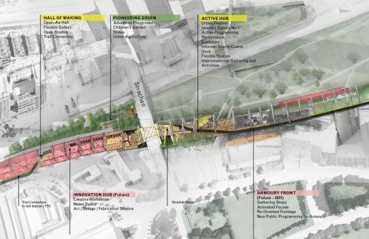
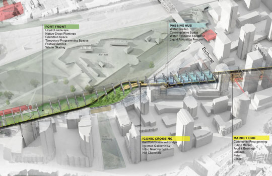
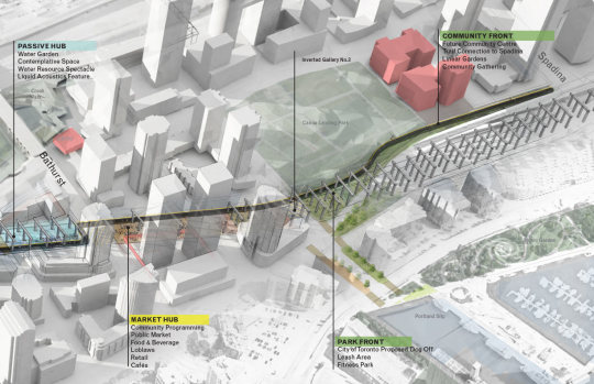
    Here’s the overall programming strategy, going from west to east (via undergardiner.com):

    imageimageimage

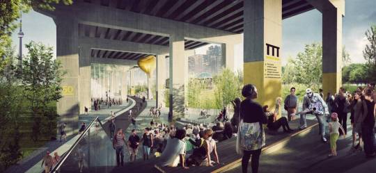
    And here are two renderings:

    imageimage

    The first phase is expected to run from Strachan Avenue in the west all the way to Spadina Avenue in the east. That is what is shown above.

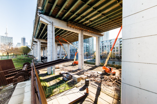
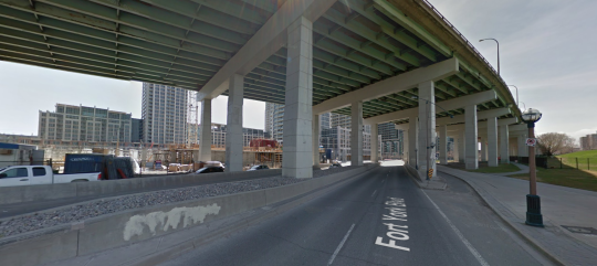
    Two key elements include a grand stair at Strachan Avenue, which looks like this today (via Google Streetview):

    image

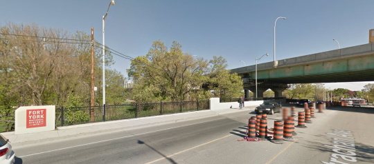
    And a pedestrian bridge over Fort York Boulevard, which looks like this today:

    image

    All of this doesn’t change my opinion of the Gardiner East, but I do believe that this is an incredibly exciting opportunity for the city. Today the space under the Gardiner is a void in our public realm.

    I also think it could be quite interesting to have these two opposing urban conditions along the central waterfront. A linear underpass park in the west and an open air boulevard in the east.

    It’s also exciting to see private money step up. It goes to show you that there is no shortage of passionate city builders in this town.

    Top image courtesy of Harry Choi Photography.

  • Blue, white, and red

    I had a few ideas bouncing around in my head today for things I could write about after I got home from the office and the gym. But now, I don’t feel like writing about any of them.

    So instead, I’d like to share this photo that I took around 9:00pm eastern time on Friday, November 13th, 2015. It’s a picture of the CN Tower lit up as the French flag.

    image

  • Will parking spaces in cities become more, or less, valuable in the future?

    Parking Garage by Nuno Silva on 500px.com

    https://500px.com/embed.js

    Lately I’ve been having discussions around the future value of parking spaces in urban centers. So yesterday I tweeted out this poll:

    //platform.twitter.com/widgets.js

    The sample size is very small, but for what it’s worth, there are some/many people who believe that urban parking spaces will become more valuable in the future.

    This is a reasonable assumption. 

    Over the last couple of decades here in Toronto, I would guess that parking ratios for new multi-family developments have probably fallen by more than half. It used to be that you had to build 1 to 1.5 parking stalls for each unit and now we seem to be sitting somewhere close to 0.5. Although, there are also exceptions and some projects today are getting built with no parking.

    So given that the supply side of urban parking spaces seems to be getting constrained and many cities are actively trying to encourage other forms of mobility, it’s not unreasonable to believe that parking stalls will only become more valuable. That’s why a new underground spot in Toronto might cost you $60,000 today and why some spots in New York can even fetch a $1 million. 

    But this assumes that the demand for parking will remain more or less the same. What if it doesn’t stay the same? What if we were to experience a tipping point that rearranged urban mobility? What if the cost of driving became so high that people stopped driving at scale? In these scenarios, the demand side of the equation would change.

    If you’re a regular of this blog, you probably know what I’m going to say next. But already I can think of two innovations that would contribute to the above scenarios: Uber and driverless cars.

    Uber’s goal is to continually drive down the cost of transportation and eventually get you to no longer own a car. They know very clearly that the demand for transportation services is highly elastic and that the cheaper they get the more you will use them. And the way they get cheaper is by continually increasing the utilization rate of their drivers/cars. An idle driver/car is the enemy.

    Of course, the other way to drive down fares is to remove the driver all together. And once you’ve done that, there is, in theory, no reason that a car should ever sit idle – like they do today. (The utilization rate for my car is around 2%.) And if a car is never sitting idle, then why would you ever need to park it? Certainly you wouldn’t need to park it as often as you do today.

    All of this isn’t going to happen tomorrow, but I believe – despite the supply constraints – that we are going to end up with excess parking spaces in our cities. And that will mean that they are going to be perceived as less valuable than they are today. I also believe that it will eventually seem silly to drive your own car. 

    What do you think?

  • How to encourage traffic congestion in your city

    City
    Observatory recently republished their
    commentary
    on a report (released earlier this year) called Who Pays
    for Roads
    . I missed their original post, so this is new to me.

    The report
    and commentary are all about the mispricing of roads/driving and the fallacy
    that “user fees” (gas taxes, tolls, and so on) are enough to completely cover
    the costs associated with driving.

    I have been
    a vocal supporter of road pricing and/or congestion charges here in Toronto, and
    so I’d like to share two pieces from their commentary.

    The first
    is this paragraph, which talks about how mispricing leads to demand issues
    (i.e. traffic congestion):  

    The conventional
    wisdom of road finance is that we have a shortfall of revenue: we “need” more
    money to pay for maintenance and repair and for new construction. But the huge
    subsidy to car use has another equally important implication: because user fees
    are set too low, and because, in essence, we are paying people to drive more,
    we have excess demand for the road system. If we priced the use of our roads to
    recover even the cost of maintenance, driving would be noticeably more
    expensive, and people would have much stronger incentives to drive less, and to
    use other forms of transportation, like transit and cycling. The fact that user
    fees are too low not only means that there isn’t enough revenue, but that there
    is too much demand. One value of user fees would be that they would discourage
    excessive use of the roads, lessen wear and tear, and in many cases obviate the
    need for costly new capacity.

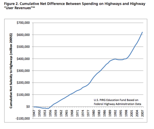
    And the second is this chart, which shows the cumulative net
    subsidy to highways in the US from the late 1940’s:

    image

    The point of all this is that when you subsidize something
    it’s because you’d like to see more, not less of it. So why then are we even surprised by the crippling traffic that plagues our
    cities? We are doing a lot to encourage exactly that.

  • Make Way for Laneway

    I was speaking with a friend this morning and he told me that he had a Pavlovian association between me and laneways. That made me happy. 

    If you’re a regular reader of this blog, you’ve heard me go on and on about the great potential of laneways and laneway housing (accessory dwelling units) in Toronto, as well as in other cities around the world.

    So I won’t do that today. Instead, I’m going to link to a report that was just released by the Pembina Institute called Make Way for Laneway: Providing more housing options for the Greater Toronto Area.

    The report is obviously about Toronto, but there’s no reason that the lessons and ideas won’t also apply to your city. So I would encourage you to give it a read.

    For those of you who have emailed me about my own laneway house, the project is still on hold. And it will likely remain that way until the city becomes a bit more accepting of this housing typology. Hopefully that will happen soon.

  • The London Crossrail

    On Thursday afternoon the mayor of Toronto, John Tory, was in London meeting with their mayor, Boris Johnston, and talking about Toronto-London business relations, the economy, and transit.

    Here is the tweet:

    //platform.twitter.com/widgets.js

    On the topic of transit, the big item to see and discuss was The Crossrail. For those of you who might not be familiar with it, here are a few bullet points from their website:

    Crossrail is Europe’s largest construction project – work started in May 2009 and there are currently over 10,000 people working across over 40 construction sites.

    The Crossrail route will run over 100km from Reading and Heathrow in the west, through new tunnels under central London to Shenfield and Abbey Wood in the east.

    Crossrail will transform rail transport in London and the south east, increasing central London rail capacity by 10%, supporting regeneration and cutting journey times across the city.

    Crossrail will bring an extra 1.5 million people to within 45 minutes of central London and will link London’s key employment, leisure and business districts – Heathrow, West End, the City, Docklands – enabling further economic development.

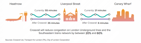
    And below is a neat diagram that I found in this City of London report. I think it does a good job summarizing some of the spatial impacts of The Crossrail.

    image

    In the past I’ve been negative about John Tory’s SmartTrack proposal, which is clearly inspired by The London Crossrail. I had my reasons for that. But I want to be clear that I am not in any way negative on Regional Express Rail as a mobility solution.

    Toronto would benefit greatly from RER and Metrolinx is working diligently to deliver it to the region. I can’t wait for that to happen so I can drive even less than I already do.