Daily insights for city builders, delivered every morning at 6 AM ET. I’m Brandon Donnelly — a Toronto-based real estate developer and founder of Globizen. I’ve been writing here since 2013.

Tag: toronto

  • Exploring the Mimico waterfront

    This morning I explored Humber Bay Park, which is a waterfront park in the west end of Toronto. It’s in a neighborhood called Mimico that used to be a separate town, with its own mayor, until 1967. I honestly can’t remember the last time I was there, so it was fun to explore what felt like a new part of the city.

    Given its proximity to downtown and the fact that it’s very well connected to the water, the area is currently facing tremendous development pressures. In fact, as I was standing in line waiting to order an Americano, the conversation happening directly in front of me was all about how developers are fighting to buy up every piece of land they can find. Normally I would chime in, but today I decided to stay silent.

    Today the area is an interesting mix of old low-rise and mid-rise rental apartment buildings (many of which fell into decline a long time ago), and new high-rise condominiums that are all fighting for unobstructed views of the lake and downtown.

    There wasn’t a ton of street or public life going on, but it was certainly a beautiful place to spend a Sunday morning. As much as I’m looking forward to getting back into snowboarding, I’m not quite ready for summer to be over. So I’m happy that we’ve been having some great weather in the city.

  • TIFF: Getting ready for guests on King Street

    image

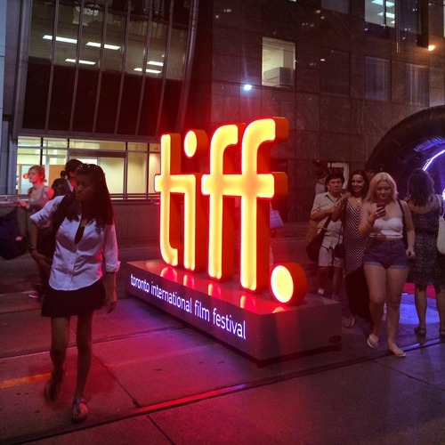
    Right now the Toronto International Film Festival is going on in the city. It’s actually one of my favorite times in Toronto. There’s so much going on and the city generally does things that it doesn’t normally allow, but that it should do all throughout the year, such as extending last call at bars and closing down streets to cars.

    This year, King Street between University Avenue and Peter Street has been made pedestrian-only. It encompasses an area known as the Entertainment District and includes the Bell Lightbox, which is the TIFF HQ. The street was closed last Thursday and will reopen this Monday. So it’s a 4 day thing, that TIFF is calling “Festival Street.”

    Some people – like me – are really excited about this. Here’s s picture I tweeted out on Thursday night. Given the engagement (retweets/favorites), I think there are others who feel the same way I do:

    //platform.twitter.com/widgets.js

    But there are others who are furious that their commute was disrupted last week and that we’re inconveniencing locals for the sake of hosting one of the top film festivals in the world. (King Street typically moves about 60,000 people per day on the streetcar and 20,000 vehicles.)

    But when I walked the entire 650 meter stretch on Thursday night, it was completely full of people. There were people playing large-scale chess. There were people eating at picnic benches. And there were lots of people just enjoying a wonderful summer stroll in the city.

    And all I could think about is that this is an unmet need in the city. King Street is a wonderful place to be right now and we don’t have an equivalent during the other 361 days of the year here in Toronto. So rather than be upset that we’ve closed down 6 blocks of downtown, I’m only upset that we don’t do more of this and make it permanent during the rest of the year. 

    I’m not necessarily saying that King Street is the best place to do this. Yonge Street initially strikes me as being a better place to start. But I am saying that if we have to reconfigure things to make our city more awesome for when guests come over, that maybe we should think about how to make it more awesome all the time.

  • The war on the car

    image

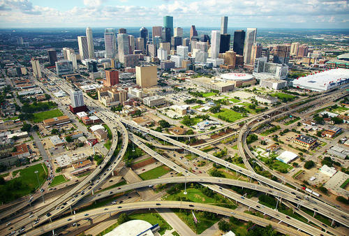
    In today’s post I’d like to focus on the second tweet I embedded in yesterday’s piece about downtown Toronto. Specifically, the fact that almost 75% of downtown residents walk, cycle, or take transit to work, leaving drivers firmly in the minority.

    For me, this then makes me question whether or not we’re optimizing well enough for the majority. However, it’s often not that simple. And that’s because the downtown core is clearly regional in its draw, and the further you move out from the downtown core, the more the modal split flips. In the suburbs, driving is obviously the majority.

    And herein lies the tension and the reason for all this “war on the car” rhetoric: We have a downtown core with completely different mobility preferences than the rest of the region.

    But as Toronto continues to intensify and grow (the population of the Greater Toronto Area is projected to reach almost 9 million by 2036), I truthfully don’t know how we could reasonably expect to (efficiently) move that number of people in private cars. I’ve just never seen it done before.

    Some people think that if we simply got rid of all those damn streetcars on our city streets, that we’d be doing a lot to eliminate traffic congestion. But it’s not that simple. The Highway 401 here in the city is already 18-lanes and one of the widest in the world. And yet it’s perpetually clogged. No streetcars there.

    So I look at this tension as a growing pain. Sooner or later I think we’re going to realize that this war should really be a war on inefficiency. How do we move lots of people around big cities while minimizing waste, maximizing economic output, and enhancing quality of life?

    Now that’s a war worth fighting.

    Image: Helibacon

  • Downtown Toronto in numbers

    Last week I tweeted out a Tweetstorm with some of the key facts from this City of Toronto study on the downtown core. Here are two of those tweets:

    //platform.twitter.com/widgets.js

    While I realize that reading city reports is probably not everyone’s idea of fun, it is a good one if you want to understand the massive change that is taking place in Toronto right now and also the importance of the downtown core for this region.

    To put things into perspective, consider that the downtown core (including King West, King East, and the Portlands) is estimated to be responsible for 51% of the entire wealth generated in this city. And yet its physical area is easily less than 10% of the entire city (which is about 630 square kilometers).

    That’s fascinating to me.

  • Toronto approves 755 storeys of new development

    image

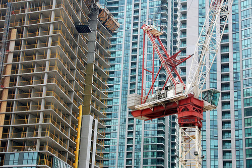
    Earlier this week, Toronto City Council approved the equivalent of 755 storeys of new development, a lot of which will end up in the downtown core. The translates into 6,887 new housing units and roughly 4 million square feet of new commercial space. The Globe and Mail called it the Manhattanization of downtown.

    If you’d like to go through the complete City Council meeting agenda, you can do that here. (I warn you though, it won’t be an exciting read.)

    One notable project that was approved is 50 Bloor Street West, which is a 71-storey mixed-use building in Yorkville adjacent to and on top of Holt Renfrew (It includes a $6 million Section 37 contribution). I mention this one because it’s impressively tall and because it’s a project that I was involved with when I was at Morguard. Watch for Yorkville in the coming years, there’s a lot in the pipeline.

    While I think this is all incredibly exciting, our chief planner, Jennifer Keesmaat, is entirely correct in pointing out that all of this highlights the desperate need for better infrastructure, the most critical of which is a relief subway line that cuts across downtown.

    But to be clear, this isn’t a question of just planning for growth. This is a question of planning for growth and making up for decades of infrastructure disinvestment. That’s the position we’re in today, which means we have a lot of hard work to do. Though I’m confident we’ll get it done.

    The other thing that this level of intensification should highlight for you is that public transit, and other forms of mobility such as biking and car sharing, have to be central to our goals. It’s simply infeasible for everybody to be driving around in a car. We’re currently demonstrating how efficient that ends up being.

    So as Toronto continues to intensify, I think we’ll quickly discover that traffic and private cars aren’t the answer or even the right question to be asking.

    Image: Flickr

  • How much should a ride on the Union Pearson Express cost?

    When I was in Chicago a few weekends ago, one of the things we did was take the train from Midway Airport to downtown. We were a large group, but since it was only $2.25 and we figured it would be easier and faster than contending with traffic, we decided to take it.

    Since it was their local transit service (as opposed to a dedicated airport rail line), the train came within a few minutes and it took us about 25 minutes to get to the Loop. It was a great experience. And I would take it again the next time I go to Chicago.

    I mention this because there’s been a lot of debate in Toronto recently about the potential ticket price for the new Union Pearson Express train to the airport. Some are suggesting that it could cost upwards of $30 for a one way ride, which would also take 25 minutes and would leave every 15 minutes.

    The concern is that at this price, the train will only serve the business community and the rich. And indeed, it’s a lot more than the $2.25 I paid when I landed in Chicago earlier this month. But at the same time the Union Pearson Express promises to offer a more refined travel experience than your regular old subway train. So how should it be priced?

    Pricing exercises are really interesting because, as David Fitzpatrick pointed out in a recent tweet, increasing the price of the ticket will lower ridership. And at a certain point, this will cause overall revenues to also decline (the loss in ridership stops being made up by the higher ticket price). So, in theory at least, there exists a magic, profit maximizing number.  

    Of course, profit may not be the only goal. One might also be interested in reducing the number of vehicles on the road, promoting sustainability, and generally providing people with a convenient way to get to and from the city’s biggest airport. And should this be case, then those factors also need to be worked into the pricing model.

    Now, I don’t know what that magic number should be off hand, but I do think we need to be clear on our goals as that decision is made.

    I personally believe that we underprice roads in this city, which is why we have such a supply and demand imbalance (i.e. gridlock). And so if we decide that rail travel should be a premium service, then I don’t think it’ll do much to correct that imbalance.

  • Streetcars are just a tool

    Earlier this month the Toronto Star published an article talking about the resurgence of streetcars in American cities. According to the Star, 89 cities in the US are currently implementing or at least considering building some form of surface-rail system.

    But the article also goes on to argue that it could be a snobbish fad. Streetcars are new. They’re shiny. And they make yuppies –  who don’t like taking buses – feel better about themselves. But is the ROI really there? Is the economic impact of streetcars as big as people are making it out to be?

    To support this argument, the Star quoted transportation planner Jarrett Walker, who I’ve mentioned here before on Architect This City. But according to a follow-up post that Walker did on his blog, it would appear that he was misrepresented in the article. Here’s a snippet of his response:

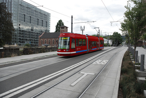
    Here’s the bottom line. Streetcars are just a tool. They can be used in smart ways and in stupid ways. Asking a transit planner for an opinion about a transit technology is like asking a carpenter what his favorite tool is. A good carpenter sees his tools as tools and choses the right one for the task at hand. He doesn’t use his screwdriver to pound nails just because he is a “screwdriver advocate” or “hammer opponent”. Yet the Toronto Star assumes that nobody involved in transit debates is as smart as your average competent carpenter.

    I wanted to share this because I think it’s a great way to approach transportation planning and because I think it gets at a larger issue that we continue to face here in Toronto: We keep politicizing mobility tools. Cyclists have become pinkos. Streetcars are a war on the car. And the list goes on. How about we just look at the problem, and figure out what solution would work best?

    Image: Flickr

  • A new vision of Yonge Street

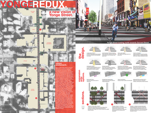
    Back in April I wrote about a competition for young people to reimagine public space in Toronto. It was called NXT City. Well that prize has been awarded and the winner was Richard Valenzona for his vision–called Yonge-Redux–of a new and reimagined Yonge Street. To download the PDF of his entry (the image shown above), click here.

    The proposal encompasses a stretch of Yonge Street that runs from Queen Street in the south, to College Street in the north. It would capture the Toronto Eaton Centre (mall), Yonge-Dundas Square, Ryerson University’s expanded Yonge Street footprint, and the massive mixed-use developments happening in the College Park area (see Aura Tower). To quickly simplify, the proposal is essentially about enhancing the urban experience, prioritizing pedestrians, and reducing the flow of cars to two lanes.

    Overall, I think it’s a wonderful proposal and I’m not surprised it won NXT City. This type of intervention is on so many of our minds. In fact, it’s somewhat surprising that we’ve been as slow as we have to improve our main street. There are so many anchor institutions, such as the Eaton Centre and Ryerson University, that plug into this section of Yonge Street. It makes a lot of sense.

    But as I said in my original post, one of the most exciting things about the NXT City Prize is that it has always been about execution. This is not just an academic exercise–or at least that’s the hope. This exercise is about spurring real change in the city and I genuinely hope that they’re successful in doing so. Because then I can turn around and say: Take that Melbourne 🙂

    Kudos to Richard Valenzona, Mackenzie Keast, as well as everyone else involved in NXT City, for making this initiative a reality and for doing your part to make Toronto even more awesome.

  • #ATHISCITY

    One of the things that makes cities so exciting is the fact that they’re always changing. New restaurants open up. New buildings are built. Old buildings (with no heritage value, of course) are demolished. Bike lanes are added. New infill homes pop up in quiet residential neighborhoods. And the list goes on.

    For years I’ve wanted an app or some sort of product that would allow city builders to keep track of everything that’s going on in their city. In the same way that Foursquare helps you find cool restaurants around you, I would like to know about everything that’s going on, from rezoning applications to construction updates.

    One of the challenges, of course, is that I’m sure more people care about cool new restaurants than about esoteric planning applications. It’s definitely a niche market. But that doesn’t mean there isn’t a thriving group of people who do care. So I’ve decided to introduce an Architect This City hashtag on Twitter: #ATHISCITY.

    I’ll be using it for city building updates and, if some of you join in as well, I think it could become a great way to keep track all of the neat things that are happening in our city, as well as in others around the world.

  • Is it time to get rid of parking minimums?

    The cost of a parking spot in downtown Toronto has reached as high as $60,000 (per stall) in some new construction projects. If you convert that to a per square foot price (which is typically how people measure condo prices), you’re looking at over $350 per square foot for that parking stall. Is it worth it?

    Most cities around the world have what is called a parking minimum. This means that to build, say a new residential condo, developers need to provide a certain number of parking stalls. In Toronto, those minimums will depend on your unit mix. Bigger units have more stringent parking requirements. 

    In some cities, though it’s much rarer, they actually have parking maximums. Portland, for instance, has a maximum number of parking stalls that you’re allowed to build, which fluctuates based on the development’s proximity to transit.

    And finally, there are some cities, such as Berlin, with no parking minimums or maximums at all. In those cases, the market dictates the number of parking stalls that should be built. If people want a parking spot with their apartment and won’t buy or rent it without one, then the developer builds it.

    Though parking variances do happen in Toronto (for reasons such as proximity to transit), the city is generally skeptical of a market led approach to parking requirements. And there are a couple of reasons for that. They worry that investors might be buying the units (with no parking) and so the sales data may not be indicative of the end-user market.

    The city also worries that developers might actively discourage purchasers from buying parking spots, as it’s usually more profitable not to build them. Underground parking is costly and often subsidized by the sale of the condo units themselves. In fact, I’ve heard of instances where underground parking has cost upwards of $100,000 per stall because of buoyancy forces and other technical details.

    But I’m generally a free market guy. So I question if the market really isn’t capable of figuring out how much parking there truly needs to be. Undoubtedly, there will be families who demand 2 parking spots. I also bought a parking spot with my condo. But there may also be a number of people who would rather pay less for their home than subsidize a parking garage that they’ll rarely use.

    And as I wrote in a recent post called, Is traffic the right question?, we could be losing sight of the greater goal. If we truly want to build a sustainable and livable city, then we should be considering how our development activity encourages transit usage over driving, and how we can promote a more balanced modal split across the city.

    What are your thoughts? Would you buy a home without parking? Should we get rid of parking minimums, just as cities like Berlin have?