Daily insights for city builders, delivered every morning at 6 AM ET. I’m Brandon Donnelly — a Toronto-based real estate developer and founder of Globizen. I’ve been writing here since 2013.
Social media, as we all know, isn’t all that real. Photos are cropped, edited, and distorted all the time. But that’s kind of how things work these days and it’s not just on social media. Back in 2014, it was revealed that about 75% of Ikea’s catalogues were made up of computer generated images. It’s simply a lot faster to do that than stage a bunch of spaces for photoshoots. Fast forward six years and Ikea is now taking it a step further by integrating “digital influencers” into their ads. Here’s what that looks like:
This particular campaign was done to promote a new store in Tokyo’s Harajuku district. And it features a popular digital influencer known as Imma. This is my first foray into the world of digital influencers, but Imma is apparently popular enough to have some 265,000 followers on Instagram. What I have just learned is that a real human is first photographed and filmed for all of this content. Imma’s digital head is then transplanted onto said content. That’s how these digital influencers are created.
It all feels very Japanese to me. It also feels a bit like the starting premise of a great Black Mirror episode. But on the other hand, is it really all that different from the highly doctored content that already graces the internet?
Who needs to travel when you have, this? This, is a site called Drive & Listen, which allows you to drive around cities — well, watch vides of people driving around cities — while listening to local radio stations. It’s oddly fascinating in an I-spend-hours-on-Google-street-view kind of way. (It’s okay if you do that too.) A colleague sent out the link this morning and I thought it was a pretty clever idea, particularly right now, when many/most of us are yearning to travel, but can’t. The first cities I visited were Buenos Aires, Tokyo, Sao Paulo, Lisbon, Berlin, and, of course, Toronto.
It has been well documented that Tokyo tends to build a lot of housing. And the argument goes that this has helped to maintain a certain level of housing affordability. The city is constantly building and rebuilding. It also has different views about housing. Now, we could, of course, debate how much of its relative affordability is a direct result of supply but, regardless, there seems to be a lot of it. In 2014, the city of Tokyo saw 142,417 housing starts, according to this recent FT article. This is compared to ~5,000 units across the Bay Area (2015 data), 83,657 units for the state of California, and 137,010 units for all of England.
If you’re wondering how Toronto is doing, here are the latest numbers:
# of units included in BPs issued (housing starts) for Toronto: 18,737 in 2019; 19,239 YTD in 2020 (Note: given multi year construction period, Toronto in the last few years has had about 45k units under construction at any one time)
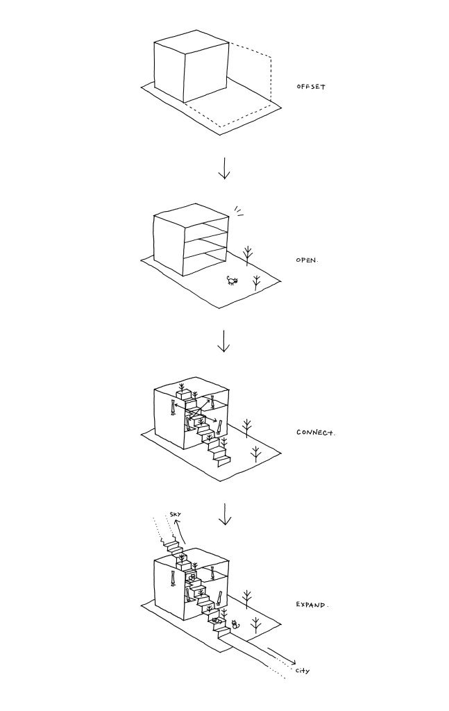
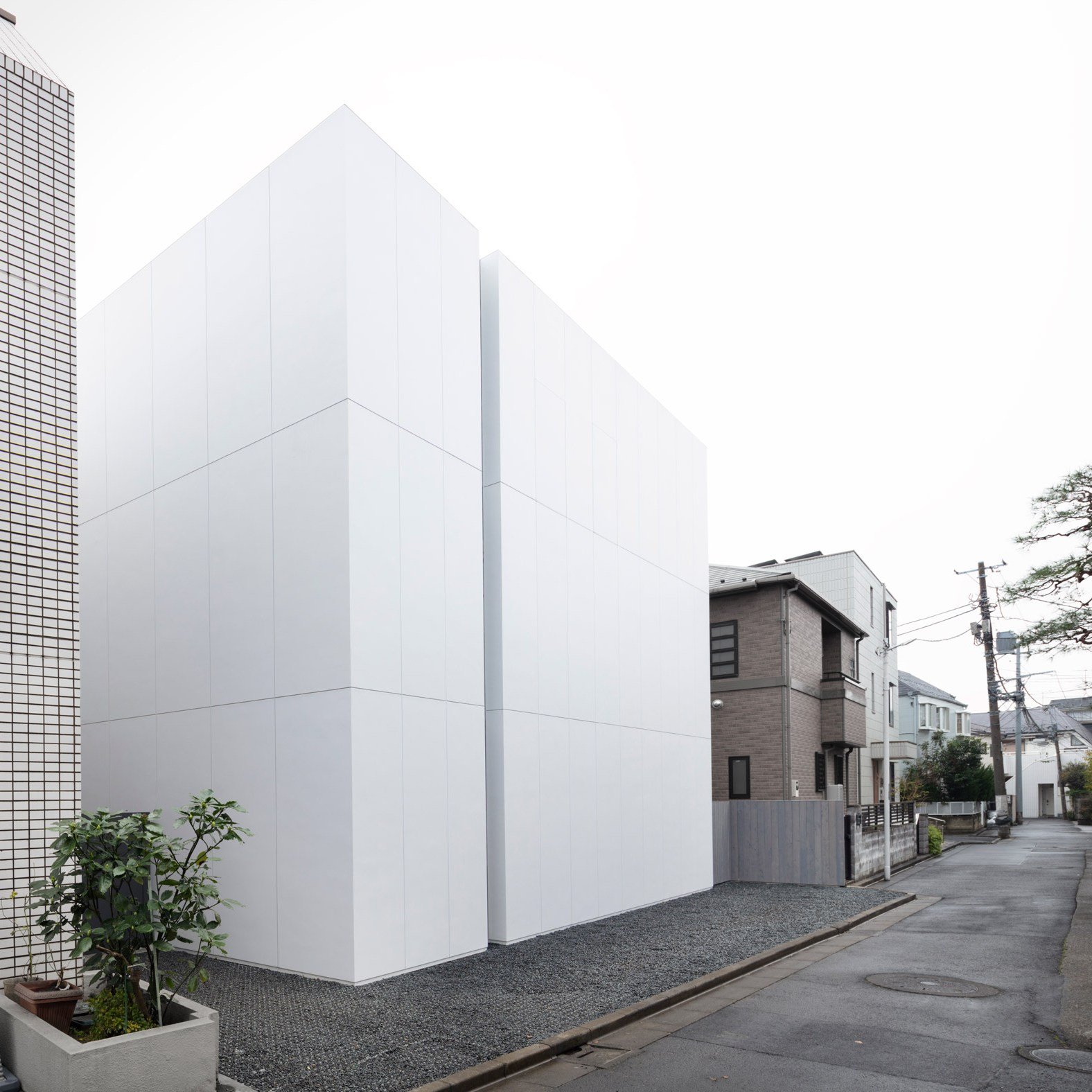
The house is setback from its south property line as a result of the surrounding context. A south-facing green space is then introduced, preserving one of the existing trees.
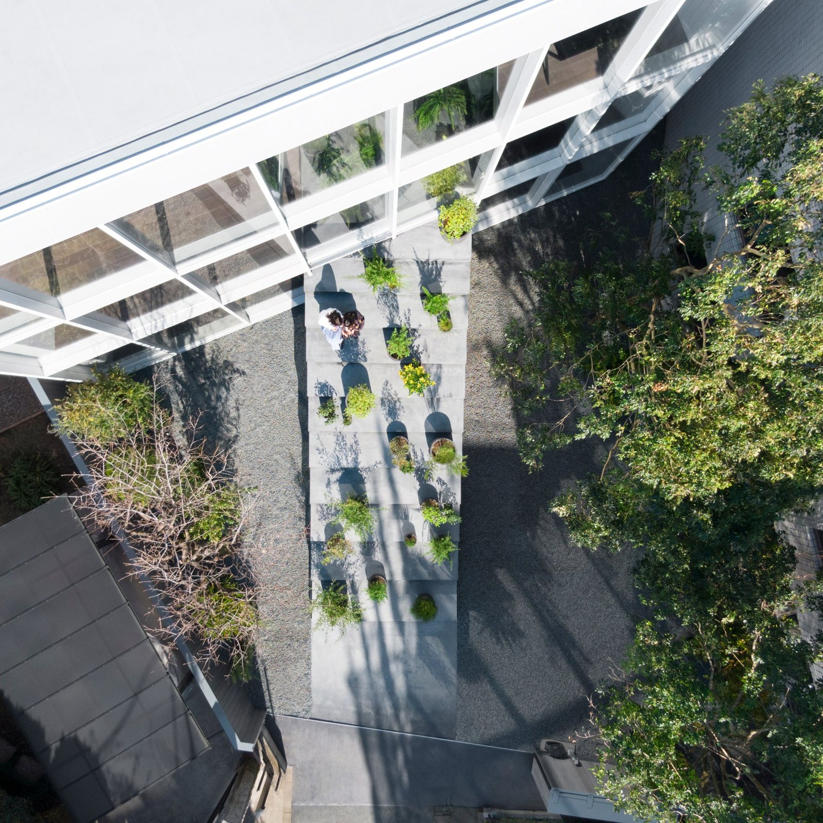
Given that the house serves as a multi-generational household, a central “staircase” is introduced that visually connects all three floors of the house and serves to mitigate any sort of feelings of social isolation across the families.
(The staircase-like structure is only partially functional.)
Finally, the staircase is then expanded outward to connect with the broader city. As you can see from the context plan below, the staircase is on axis with a neighboring city street.
Before bed last night, I was was reading about a Tokyo-based real estate company called Spilytus. They have an apartment brand called Ququri (pronounced ku-ku-ri) that specializes in tiny apartments, which I suppose isn’t all that novel for Japan.
Since the brand was launched in 2014, they have developed over 70 buildings and now manage about 1,200 micro apartments across the central wards of Tokyo (~17 units per project if you do the math). We are talking about apartments in the range of 9 square meters (plus sleeping loft) for somewhere around ¥75,000 per month.
Not surprisingly, their projects seem to lease up right away. And supposedly there’s a long wait list for future projects. People are clearly looking for affordable housing in the neighborhoods in which they want to live. It’s about lifestyle and location, and living a large portion of your life within the public domain.
This housing typology isn’t for everyone. But it’s great for some people. And I have no doubt that demand for it will only continue to grow in big global cities. However, for what we are all going through right now, I can imagine that it would be nice to have a bit more than 9 square meters to roam around in.
The Financial Times has some of the best charts/graphics that I have seen on the coronavirus and its impact. They’re also free and regularly updated. Below is the cumulative number of deaths, by number of days since the 10th death (last updated March 23 at 21:00 GMT). I prefer this to the number of cases because it is more precise, though impacted by things like demographics. The number of cases is impacted by how good you are at testing. Some countries have been far better than others. And what we are continuing to learn is that lots of people were and are completely asymptomatic.
Seeing China (and Iran?) continue to flatten out is encouraging. (Note the logarithmic scale.)
Here has been the impact to the Chinese economy. It’s slowing coming back.
And here are traffic volumes around the world. This chart was published on Sunday, March 22. At that time, Tokyo looked to be largely business as usual.
Elon Musk recently posted this Twitter survey asking if we, the people, would like “super safe, Earthquake-proof tunnels under [our] cities to solve traffic.” It was leading in that the “no” response was, “No, I like traffic.” And it was initially vague in that it wasn’t clear how these tunnels would be used. Though, most of us could probably guess. Elon later added in the thread that these road tunnels would be for zero emission vehicles only and they would be limited to EVs (from all auto companies, not just Tesla). Finally, Elon stated that these tunnels are not intended to replace other solutions, such as light rail, rather to supplement them.
At the time of writing this post, nearly 1.5 million people had responded to the survey and about 67% of them said “definitely” to Earthquake-proof tunnels. Elon’s reaction: “Stop whining, subway Stalinists, the people have spoken.” Notwithstanding the majority, this is a divisive topic and the reactions are mixed. City planner Brent Toderian responded by saying that this “solution” would merely result in more cars, more driving, and more emissions. Steve Jurvetson, on the other hand, argued that this would be the cheapest way to add lanes and prepare for the inevitable EV-only future. (Steve sits on Tesla’s board and recently launched a venture fund that, among other things, invests in sustainable mobility.)
The crux of this divide is a view about how cities should work. And it often becomes like dogma. Is it optimal for us to all be driving around in individual vehicles — EV or not? Will autonomous vehicles actually help solve the traffic problem? Or is building on the backbone of mass transit the only way to properly design a big and efficient city? Whether it’s lip service or not, Elon seems to acknowledge that both cars and transit are important, and that both can work together to supplement each other.
What is clear to me is that cities, at the scale of say Tokyo, wouldn’t function nearly as efficiently if it weren’t for their extensive fixed rail networks. At the same time, there are many cities (or portions of cities) that do not have the prerequisite population and employment densities to support this same level of transit investment. And that has created a strong pull away from transit (and active transport such as cycling) toward private vehicles. Sprawling cities signal to people that they should probably be driving. This is one of the reasons why land use should never be separated from mobility discussions.
How autonomous vehicles change all of this remains to be seen. Though I do think it will make cars less private and more public transit-like. Studies show that most of us are pretty good at coming up with incremental improvements to the things we already know and understand. i.e. This is how I would make this car better. But we’re far worse at coming up with and predicting tectonic shifts in the landscape. And autonomy is probably one of those shifts. But as long as our built form remains heterogeneous, I am inclined to believe that a mixture of mobility solutions will be needed. Maybe that means car tunnels. Or maybe it doesn’t.
This UN report (2018) on urbanization trends is a fascinating way to understand how our world is growing and changing. So today’s post is about some of my takeaways. If you have others, feel free to add them to the comment section below.
But first, some definitions.
The UN report considers 3 ways to measure the size of a city, all of which we have used before on this blog. The first is the “city proper.” That is the current administrative boundary of a city. The second is the “urban agglomeration” area, which is a city’s contiguous built-up area. And the third is the “metropolitan area,” which is the approximate area of economic and social interconnectedness.
Above is what these 3 boundaries might look like for Toronto (which is the example they use in their report). About the only one that isn’t debatable is the “city proper” boundary; but it really doesn’t capture the full extent of a city. Wherever possible, the UN report relies on the city’s urban agglomeration area. They also define a “megacity” as a city of over 10 million people.
The largest city in the world is currently Tokyo. However, from 2018 to 2030 it is expected to decline by almost 900,000 people. Whereas, the city in 2nd position — Delhi — is expected to add more than 10 million inhabitants during this same time period. By 2030, these are expected to be the largest cities in the world:
Most current megacities are located in what the UN refers to as the “Global South.” And 9 out of the 10 cities projected to become megacities by 2030 are located in developing countries. The one exception is London. Though all regions in the world are becoming more urban, the real population growth is happening in Asia and Africa.
Most cities — 59% of cities with 500,000 or more people — are at risk of at least one natural disaster. And 3 megacities — namely Manila, Osaka, and Tokyo — are high risk for 3 or more types of natural disaster.
Going through the report’s data charts, it’s also interesting to note that Toronto is not projected to become a megacity by 2030. However, the Toronto area already represents over 20% of Canada’s entire urban population.
In the United States, Chicago’s urban agglomeration is projected to continuing growing and does come close to megacity status by 2030. The Miami region is similarly expected to grow and is actually right on top of Toronto in terms of population. But the fastest growing regions are, of course, expected to be the city’s that can more easily sprawl (Las Vegas, Phoenix, and so on).
Bogotá, Colombia is already a megacity and is expected to add almost 2 million people by 2030. It currently represents about 26.5% of the country’s entire urban population. São Paulo remains one of the top 10 largest cities in the world and is similarly projected to add over 2 million people in the same time period, but to a much larger base.
In Europe, it’s London, Paris, and Moscow, with the latter two already in possession of megacity status.
Now quantity isn’t everything. Despite not ranking in the top 10 in terms of population, both New York and London are widely considered to be the world’s preeminent global cities. At the same time, we do know that the size of a city does create certain socioeconomic benefits. Urban agglomerations create agglomeration economies.
If you’d like to download a copy of the World’s Cities in 2018 (United Nations), click here.
Joshua Levine’s recent (WSJ Magazine) piece on John Pawson, — the architect who “elevated nothingness to an art” — is a good read.
It’s mostly about the country retreat that he recently completed for himself and his wife in the English countryside, but there’s also lots about his minimalist architecture, his career, his work with hotelier/developer Ian Schrager, and his passion for photography.
I like this bit about architectural simplicity. The great irony of minimalism, and the reason why brands such as Calvin Klein and Jil Sander began working with John Pawson to leverage his aesthetic, is that it’s often more difficult to do less. Getting the details right costs money. Hence this great line from the New Yorker:
As the New Yorker cartoon put it, “Only the rich can afford this much nothing.” Don’t expect a rebuttal from Pawson. “It is big, and it is expensive, you know. It’s sophisticated architectural simplicity. This isn’t a religious thing, and it isn’t as simple as you can go. You can go a lot simpler than this.”
I also like what the following says about labels and what it means to be defined as something:
Slowing down for Pawson isn’t all that slow. He takes photos constantly and has always used the camera as his third eye. In 2017, Phaidon published Spectrum, a book of his photos, many of them first posted on his Instagram (“I said, ‘Well, I’m not a photographer,’ and they said, ‘You are a photographer,’ so now I’m a photographer”).
Click here for the rest of the article from WSJ Magazine. And if you aren’t familiar with John Pawson, here is his minimal website.
In commemoration of the company’s 100th anniversary, Japanese rail operator, Seibu, recently unveiled a new commuter train designed by Pritzker Prize-winning architect Kazuyo Sejima. Sejima is a founding partner in the Tokyo-based firm SANAA, which has started branching out beyond buildings. She recently designed a neat and multi-functional bag for Prada.
One of the key features of the “Laview” commuter train is its unusually large 1.35m x 1.58m windows. They’re designed to maximize views, as this particular route travels from the city and into the mountains. It’s a simple design move, but it’s one I have never seen before. The overall result is quite beautiful and it goes to show you just how much the Japanese value train travel.