Daily insights for city builders, delivered every morning at 6 AM ET. I’m Brandon Donnelly — a Toronto-based real estate developer and founder of Globizen. I’ve been writing here since 2013.

Tag: streetcar

  • Waterfront Cities of the World comes to Toronto

    image

    This morning I was interviewed for a Montreal-produced TV show called Ports D’Attache. The English version of the show is called “Waterfront Cities of the World” and it airs on Discovery. 

    Here’s a list of all the cities they’ve visited in the first 4 seasons and here are all the shows from the first 2 seasons in English (which you can watch online for free).

    Rather than a travel show, it’s a look at the “spirit and soul” of each waterfront city through the lens of “local personalities.” There’s definitely a lot of fodder for city geeks and so I thought you all might find the series interesting.

    Toronto was the last stop of season 5. The other cities from this season include Philadelphia, Budapest, Rome, Taipei and Kuala Lumpur, to name only a few of them. 

    I’m glad that they decided to come to Toronto and I’m delighted that they invited me to be on the show. The team was great and, if you haven’t already noticed, I love supporting this city.

    The show will first be released in French (with my comments dubbed over), but an English version will follow. Once that version is released, I’ll circulate a link.

  • 8 tips for building better cities

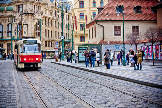
    Photograph Tram by Federico Venuda on 500px

    Tram by Federico Venuda on 500px

    My friend Alex Bozikovic of the Globe and Mail recently wrote a great article called: Expert advice on building the city of the 21st century. It’s a nice tie-in to a post I wrote a few weeks ago talking about the need for an urban agenda.

    For Alex’s article, the Globe asked “prominent urbanists, architects, and scholars” from around the world to comment on what Canadian mayors should be focused on right now as we build the cities of tomorrow.

    Here’s a list of what they said:

    1. Make people, not cars, happy
    2. Decrease speed limits
    3. Empower city governments
    4. Leverage density
    5. Embrace the science of big data
    6. Mix residences and workspace
    7. Turn streets into destinations
    8. Redevelop the inner suburbs

    It’s a great set of recommendations. So I would encourage you to check out the full Globe and Mail article.

  • Leveraging LRT

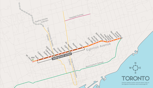
    One of the biggest pieces of infrastructure currently under construction in Toronto is the Crosstown LRT line, which will run on and under Eglinton Avenue right through the heart of midtown. The total length of the line is 19 km, and 10 km of it will be underground along with 12 of its stations.

    Here’s a map:

    image

    But as the Chief Planner of Toronto, Jennifer Keesmaat, rightly pointed out in this blog post earlier this year, it’s important to think of this line, not just as a piece of transit infrastructure, but as a broader city building initiative. With this line comes a tremendous opportunity to rethink and rebuild one of Toronto’s most important avenues.

    I have no doubt that this will happen over the coming years and decades. I mean, just look at the development activity taking place on St. Clair Avenue West right now, which you could argue is the result of its right-of-way streetcar line. But in this instance, what I’m specifically curious about is what will happen at each of the stations along Eglinton Avenue.

    If you take a look at the Stations and Stops page on the Crosstown website, you can see where all of the primary and secondary entrances will be and how each station will generally function. But what is not clear is whether we will be using this opportunity to build additional density on top of them.

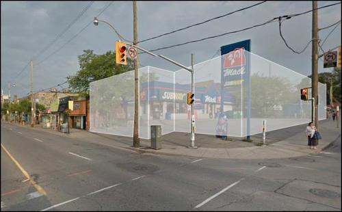
    Here’s how they have “blocked out” the primary entrance for Avenue station:

    image

    I have no idea what it’ll become. But if it ends up as single-storey and single-purpose building, then I think we will have missed an opportunity. And the same goes for many, if not all, of the other stations along the Eglinton Crosstown line. Fixed rail is such a massive driver of real estate value, and so it seems silly not to take advantage of that in some way.

    If anyone has any insights into how these stations will or will not be developed, I would love to hear from you in the comment section below.

  • Riding the new streetcar

    image

    This afternoon I rode Toronto’s new streetcar for the first time on my way home from Chinatown. I had been meaning to do it for weeks now, but this was my first opportunity.

    The experience was infinitely better than what you get today on our current streetcars. I felt like I was in a new city. The proof-of-payment system makes onboarding much faster and the 4 loading doors means you just get on the train where there’s the most room – instead of getting on at the front and fighting your way to the back.

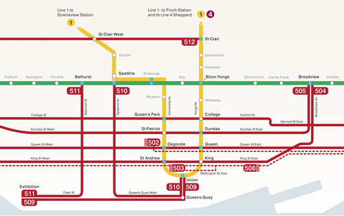
    The other thing I liked is that they now have a map of our streetcar network within the train (see above image). Toronto never used to do this. For whatever reason, we didn’t like mixing subway lines with streetcar lines on the same map. 

    But why be so pedantic?

    For one thing, our subway map looks pathetic without these additional streetcar lines on it. So for the sake of Torontonian morale, please fill it up with what you can.

    But the other reason why I think it’s important to include them is that we shouldn’t be thinking about our cities just in terms of specific technologies (subway, streetcar, and so on). Our cities are now multi-modal. Which means we navigate them using many different means, from subways and streetcars to bikes and Uber cars. What people care about is getting from A to B in the most efficient and enjoyable way possible.

    This may seem like a subtle distinction, but it’s an important one. And maybe, just maybe, these new maps will serve as an important reminder to us that there’s a lot of fixed rail in this city and that it could be far better optimized if we just tried a little harder.

  • TIFF: Getting ready for guests on King Street

    image

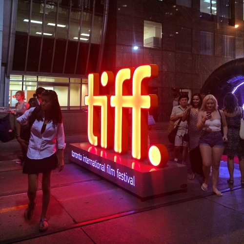
    Right now the Toronto International Film Festival is going on in the city. It’s actually one of my favorite times in Toronto. There’s so much going on and the city generally does things that it doesn’t normally allow, but that it should do all throughout the year, such as extending last call at bars and closing down streets to cars.

    This year, King Street between University Avenue and Peter Street has been made pedestrian-only. It encompasses an area known as the Entertainment District and includes the Bell Lightbox, which is the TIFF HQ. The street was closed last Thursday and will reopen this Monday. So it’s a 4 day thing, that TIFF is calling “Festival Street.”

    Some people – like me – are really excited about this. Here’s s picture I tweeted out on Thursday night. Given the engagement (retweets/favorites), I think there are others who feel the same way I do:

    //platform.twitter.com/widgets.js

    But there are others who are furious that their commute was disrupted last week and that we’re inconveniencing locals for the sake of hosting one of the top film festivals in the world. (King Street typically moves about 60,000 people per day on the streetcar and 20,000 vehicles.)

    But when I walked the entire 650 meter stretch on Thursday night, it was completely full of people. There were people playing large-scale chess. There were people eating at picnic benches. And there were lots of people just enjoying a wonderful summer stroll in the city.

    And all I could think about is that this is an unmet need in the city. King Street is a wonderful place to be right now and we don’t have an equivalent during the other 361 days of the year here in Toronto. So rather than be upset that we’ve closed down 6 blocks of downtown, I’m only upset that we don’t do more of this and make it permanent during the rest of the year. 

    I’m not necessarily saying that King Street is the best place to do this. Yonge Street initially strikes me as being a better place to start. But I am saying that if we have to reconfigure things to make our city more awesome for when guests come over, that maybe we should think about how to make it more awesome all the time.

  • Streetcar Developments buys heritage strip club

    image

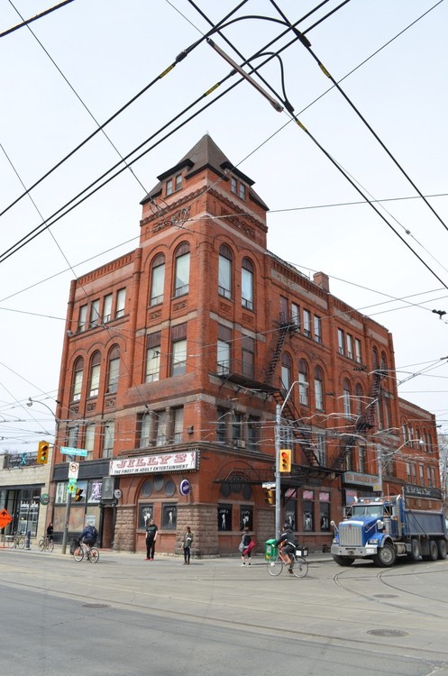
    The big news in Toronto real estate today is that Streetcar Developments has picked up the Broadview Hotel at the northwest corner of Queen Street East and Broadview Avenue in the city’s east end. The building is best known for housing Jilly’sthe finest in adult entertainment.

    I don’t know what it sold for, but the twittersphere seems to think it went for somewhere between $4 and $6 million. My guess is that it’s on the higher end of that range.

    The deal is interesting because there have been rumors circulating for years about its future. At one point there were rumblings that it was going to become a Drake Hotel on the east side–which does seem like a natural fit, and would be exciting for the Riverside area.

    And while we still don’t know what it’s going to be, Streetcar–which is a condo and loft developer–has said the plan isn’t to turn it into residential condos:

    “Although rooted in loft development, Streetcar does not see this building as a residential condominium project. We are in the early stages of planning, but our focus is to revive this building to a landmark everyone in the area can be proud of.”

    That’s interesting. They also don’t deny that it could remain a hotel.

    I don’t want to automatically assume that something along the lines of the Drake Hotel (a hotel, bar, restaurant and cultural community center) is the right recipe for this building, but I do think there’s an opportunity for it to become a significant anchor–even more so than Jilly’s–on the east side of downtown.

    Earlier this week I wrote about the rise of the east end. Maybe this will end up as the establishment that really gives West Queen West a run for its money. But in order to do so, I think Streetcar will need to find the right cultural entrepreneur to partner with. You can’t fake being effortlessly cool.

    Either way, I’m thrilled that this building–built in 1893–will be preserved. If there were any plans to demolish it, I would chain myself to a stripper pole in protest. The Broadview Hotel is a real gem with loads of potential.

  • Every street can’t be everything to everyone

    Yesterday I spoke about why Toronto shouldn’t be so quick to dismiss streetcars and light rail. Today, I’d like to talk about some of the hard decisions we need to face if we really want to get our city moving.

    Toronto is a city of neighborhoods and small main streets–at least in the areas where our streetcars live. Streets such as King and Queen are only 4 lanes. And the problem we’re facing is that we’re trying to accommodate every single use case on them: cars, on-street parking, cyclists and streetcars. But in doing so, we’ve made the experience terrible for everybody. Streetcars move at a snail’s pace, drivers are frustrated by the lumbering streetcars, cyclists fear for their life driving by parked cars (doors can swing open at any time), and so on.

    And with the rise of downtown shoulder neighborhoods such as Liberty Village, King West, the Distillery District and the soon to be complete West Don Lands, the strain on our east-west corridors is only going to get worse–much worse, in fact. Already the King streetcar is the busiest streetcar route in the city, moving almost 60,000 people per day. That’s more than the (under utilized) Sheppard subway line.

    What I hope is clear to the ATC community though, is that the answer isn’t uniformly the car. We can’t have every single resident from Parkdale to Leslieville hopping into their car and driving downtown to their office at Yonge & King. It ain’t going to work. And so we’re going to need to make some difficult decisions about how we’re going to get our city moving on the backbone of transit.

    Sure the downtown relief subway line (screw the politics I’m attaching it to downtown) would be the ideal solution to connecting our emerging shoulder neighborhoods, but that’s not going to happen overnight. And so how do we improve the efficiency of what we already have? First, we need to accept the fact that every street isn’t going to be everything to everyone at all times. We need to choose who we want to optimize for.

    So here’s an idea that’s been floated many times before but never acted upon: let’s get rid of cars on King St and Queen St in the core during rush hour.

    This would give our streetcars the room to efficiently move people across downtown, minimizing the dreaded “bunching up” that occurs as a result of traffic congestion. It would make transit a reliable choice and there are ways to pilot it. But let’s be clear: this is not about being anti-car. It’s about optimizing uses and getting people moving. Cars would continue to get priority on Richmond St and Adelaide St, and transit riders (as well cyclists) would get priority on King and Queen.

    Of course, the Rob Ford viewpoint would say that we should be optimizing all streets for cars and getting the streetcars completely out of the way. But if that’s the approach we want to take, then we’re building the wrong kind of city. We shouldn’t be focused on intensifying and creating new inner city neighborhoods, because that only tips the scale in favor of transit. Instead, we should be focused on decentralization.

    But that’s what not we’re doing. We’re intensifying our city to the point that we’re now faced with a number of difficult–yet enviable–decisions about how we’re going to live and how we’re going to move around in the future. We’re a city in transition.

    Our mission here should be to figure out how to move people around the city as efficiently possible. Let’s put politics aside and recognize that time is one of our most precious resources. And when we put people in lumbering streetcars and debilitating traffic jams, we’re completely squandering that resource. It hurts productivity and it hurts our overall prosperity as a global city.

    There’s a place for subways, streetcars, buses, bikes and cars in our city. So let’s just get on with making them all work.


  • Improving urban mobility

    If you’ve ever ridden a busy Toronto streetcar, you’ll know this story:

    You’re waiting outside in the cold for a streetcar. When one–actually 4–finally arrive all bunched up together, they’re so packed with people that you’re not actually able to get on. You try one anyways and the driver makes an announcement for everyone to “move back” so that more people can onboard via the front door. After a few minutes of people shuffling to try and get further back, you’re finally able to squeeze on–even if you are virtually sitting on the driver’s lap. You then travel about 2 blocks before the streetcar stops and the same thing repeats. The result is an absolutely infuriating mobility experience that usually makes walking the preferred choice. Who said that downtown already has enough subways?

    Over the weekend, I was watching this TED talk with Charlie Rose interviewing Larry Page of Google. One question that Rose asks Page is about why he’s so fascinated with transportation and mobility. That is, why is Google so committed to driverless cars? Page then talks about his experience of waiting for buses when he was a student at the University of Michigan and how he would think about all the inefficiencies in the system. He also talks about how half of the urban fabric of Los Angeles is made up of roads and parking lots and that this is a terrible outcome of the mobility choices made in that city.

    I’ve said before that transportation is one of the biggest challenges facing Toronto today. And I truly believe that. But that’s probably the case in most, if not all big cities. Getting people around a city efficiently is such a fundamental need. It stimulates economic growth and it improves quality of life. And those are typically the reasons why people choose to live in cities: to make money and to have a better life. 

    Now, I’m a big proponent of public transportation, but I’m also excited by the advances being made outside of mass transit. With driverless cars, electric cars, networks such as Uber and Hailo, and the emergence of the sharing economy, you could easily imagine a bunch of different ways in which mobility could be improved in our cities. Take, for my example, my own driving patterns. I probably drive my car 2, maybe 3 hours per week these days. That translates into a weekly utilization rate of roughly 1.2%! (2 hours / 168 hours week). That’s terribly inefficient. We can do better. And I think we will.

  • Transit vehicle capacities compared

    I was cruising the twitter sphere yesterday when I came across the following chart, outlining the various transit vehicle capacities here in Toronto. It was created by Cameron MacLeod of #CodeRedTO, which is a grassroots group advocating for “a rational, affordable, and achievable rapid transit strategy for Toronto.”

    image

    On the left you have the vehicle type and then you have the capacity in terms of number of seats and standing room. The planned capacity is essentially the sum of those two numbers and the “unsafe crush load” is the number of people you could fit if you really put your back into it.

    Articulated buses refer to the longer (1.5x) bendy ones and, similarly, ALRV streetcars are the longer, articulated version of our regular streetcars. The low-floor streetcar is similar to what Toronto will be getting. And SRT is the Scarborough Rapid Transit system.

    The chart also compares between vehicle types: How many cars would you need to move the same number of people? How many buses? And so on. As one example, you would need 15.9 buses or 982 cars to move the same number of people as the Yonge subway line!

    What’s missing from the above chart though is light rail transit (LRT), which is comparable to the linking of up to 3 low-floor streetcars. In the case of the under construction Eglinton Crosstown LRT line, the planned capacity is 750 people!

    This is an hugely important takeaway because many people, including our own Mayor, do not properly distinguish between streetcar and light rail. The two are not one and the same. LRT has the potential to move a lot more people.

    In fact, at 750 people, the Eglinton Crosstown could move more people than the Sheppard subway line, which is only operating on 4 cars (as compared to 6 on our other subway lines).

    So while it’s all fine and dandy to bang our fists on the table and advocate for subways, they don’t make economic sense in all parts of our city. With the Sheppard line, we’ve been leaving capacity on the table and wasting taxpayer money.

    Of course this chart is also useful for those outside of Toronto. What I like about it is that it clearly shows the tool chest available to cities when it comes to building transit. Every city and neighborhood is different. And I think it’s important to have intelligent conversations about what makes sense in each.

    Thank you to Cameron and #CodeRedTO for allowing me to post their work.

  • Turning St Clair and Spadina into LRT

    I’ve talked before about how Toronto doesn’t currently have any true light rail transit lines. LRT does not equal what we have on St Clair Avenue. The stops are spaced far too close together. It’s just a streetcar on its on right of way.

    This is better than a streetcar that doesn’t have its own right of way, but it could be better. So here’s an idea for better optimizing some of the transit infrastructure we already have: let’s convert the St Clair and Spadina streetcar lines into true LRT.

    Here are 3 things we could do.

    1.

    First, we need to get rid of some stops. Let’s take the stop spacing being proposed for Eglinton Avenue and apply it to St Clair Avenue and Spadina Avenue. By stopping less, it means performance goes up. Think about how much time is wasted every time the streetcar has to stop for people to get on and off. This is why New York has express trains.

    Alternatively—and instead of actually getting rid of some stops—we could also just operate two types of stops: rush hour stops and off-peak stops. In the case of off-peak stops, the streetcar would simply skip them during rush hour. The cost of implementing this would be signage and consumer education.

    2.

    Second, we finally roll out a better payment system. While tokens do give me a kind of 1960s nostalgia, I hate change and I hate fumbling with microscopic tokens in my pocket. Why isn’t there an app for this?

    But more importantly, if we had a better payment system we could transfer the point of payment from the actual streetcars to the stops themselves. This would mean that you’d need to pay in order to gain access to the stop itself. The benefit of this though is that it streamlines onboarding. Customers can now just walk onto the streetcar, like they do on the subway.

    And if you’re thinking about those times where you give up waiting for a streetcar and just hail a cab, well we could simply make the fare refundable if you leave at the same stop. This type of system would also open up the possibility of distance based fares (see London, Tokyo, etc.)

    3.

    Third, put the LRT lines on the subway map and operate them with the same rigour. Right now the customer experience gap between subways and streetcars is huge. Subways run on time and streetcars are completely hit or miss. There’s an excuse for streetcars that run mixed in with traffic, but I don’t see why we can’t make light rail (using its own right of way) just as predictable as subways. I used to take the LUAS in Dublin everyday and it was a fantastic experience.

    We really need to start taking transit more seriously in Toronto. I don’t know about you, but I’d much rather be known around the world for having the best transit system than for having a debaucherous mayor.