Daily insights for city builders, delivered every morning at 6 AM ET. I’m Brandon Donnelly — a Toronto-based real estate developer and founder of Globizen. I’ve been writing here since 2013.

Tag: sidewalk toronto

  • Sidewalk Labs, Uber, Lime, and the demise of urban density

    Today I am going to talk about 3 things that recently happened and/or that are on my mind.

    Sidewalk Labs pulled out of Toronto. I think this is sad. A lot of people have said that they’re surprised, but not surprised. The official reason is that this unprecedented environment has made it financially infeasible for them to develop the 12-acre site, while still adhering to their core principles. I don’t have any inside knowledge of the situation, but I can’t help but think that this is probably just an opportune excuse. They were getting beat up pretty badly by Toronto on all fronts, even though they had put forward an incredibly ambitious development proposal. As I said before, I can’t imagine many (or any) “conventional” developers coming forward with something like this. The last plan I saw was 1/3 non-residential, and 40% of the residential component was to be priced below market. And never mind all of the other innovations that were being contemplated.

    In other tech news, Uber just led a $170 million investment in Lime (the micromobility scooter company). I think this is smart — both from an overall mobility standpoint and, selfishly, as a shareowner of $UBER. It is being reported that this round of investment values Lime at about $510 million. This is a 79% decline from April 2019 when it raised its last round. So presumably, Uber is getting a pretty good deal here. The bet is that the urban landscape demands multi-modal transportation solutions, everything from bikes and scooters to cars and public transit. There is also an argument to be made that in the short-term, our post-pandemic world is going to gravitate toward individual mobility and away from things like public transit. I’ve heard a few people say that, as we re-open the global economy and try to maintain social distancing, we’re going to face two major mobility bottlenecks: transit and elevators. Sounds like more testing would be a prudent idea.

    Above, I was very careful to say “in the short-term” because I think the narrative that is emerging around the demise of urban density is entirely overblown. Few of us are clamoring to jump back into a mosh pit right now (perhaps a metaphorical mosh pit), but I also don’t believe that we will suddenly look to sprawling Brasilia as a source of urban inspiration. While it is true that “disease did shape architecture in the 20th century” (Alex Bozikovic wrote a good piece on this over the weekend) and that there have been oscillations in terms of how we view urbanity, I also know that this isn’t the first pandemic that our cities have lived through. The Hong Kong flu of 1968 is thought to have killed one million people around the world after, allegedly, emerging in one of the densest cities ever created. Hong Kong’s relationship with Beijing is a tenuous one right now, but it still remains one of the world’s most important global cities.

    Perhaps cities are more resilient than we give them credit for.

    Photo by Touann Gatouillat Vergos on Unsplash

  • Sidewalk Toronto advances to the next phase

    In June of this year, Sidewalk Labs released its draft Master Innovation and Development Plan (MIDP) for Toronto’s eastern waterfront. I wrote about it here. It was a draft document that was subject to further discussion and refinement, with October 31, 2019 being an important deadline for a lot of that to happen.

    Some of the critical issues included project scope (just Quayside?), the possibility of a Waterfront LRT (needs to happen), data governance (who owns and manages the data that will be generated by this new smart city?) and, of course, land value. How much is Quayside worth?

    A number of these key issues have now been “realigned,” including the land value piece. Waterfront Toronto and Sidewalks Labs have agreed on a fair market value of $590 million (before accounting for any investments that will be required in order to achieve Waterfront Toronto’s goals).

    For a summary of the critical issues and what has been agreed to, click here. With these items now firmed up, Waterfront Toronto’s board voted unanimously to proceed to the next phase. The next critical date is March 31, 2020, which is when the project will seek final approval. Mark your calendars.

  • A new approach for inclusive growth

    Sidewalk Labs just released its draft Master Innovation and Development Plan (“MIDP”) for Toronto’s eastern waterfront. It’s called Toronto Tomorrow: A New Approach for Inclusive Growth, and it’s massive. Over 1,500 pages. It consists of an overview and 3 volumes, all of which can be downloaded here.

    At a high-level, the objectives of the plan are twofold. They want to revitalize the eastern waterfront (it’s currently appalling) and they want to test new urban ideas that could benefit the broader city, as well as the rest of the world. Deploying new technologies at a larger scale is one of the ways the company intends to make money.

    I am still working my way through the plan (I may never finish), but here’s a breakdown of the development program for the Quayside precinct:

    If you’re looking for a quick overview of the plan, here are five things to know about the Sidewalk Toronto project and here is an overview of the public-private partnership that they are proposing. Of course, there’s also no shortage of criticism on Sidewalk’s plans for the waterfront. Some links here, here, and here (paywall).

    Sidewalk Labs is trying to assuage public concerns through some of its open commitments. They have said that they will not seek special tax subsidies, control urban data, sell personal info and/or use it for ads, or develop the entire eastern waterfront themselves. But the plan remains highly controversial.

    I think part of the issue is that, because so much of what they are proposing hasn’t been done before, there are a lot of unanswered questions and a great deal of uncertainty around the future. Many are interpreting this as the company hiding its true intentions. Maybe it is. Or maybe it isn’t.

    But let’s not forget what Waterfront Toronto requested back in 2017 for these lands. It wanted an innovation and funding partner:

    Waterfront Toronto is seeking a unique partner, one with invention ingrained in its culture, which can transform conventional business practices and help to establish a benchmark climate positive approach that will lead the world in city building practices.

    There’s no question that what Sidewalk Toronto has put forward is bold. As I scanned through the plans today, I found myself hard pressed to think of any “conventional” developer that would be willing to come forward with a proposal as ambitious as this one.

    As you all know, Sidewalk Labs’ parent company is called Alphabet. But I think it’s worth mentioning that “alpha” is a finance term that refers to the excess return of a strategy beyond that of a benchmark index. Put differently: How much better are you than the status quo?

    The whole point of Alphabet is that they’re supposed to make “alpha bets” on ambitious projects. They are given the “resources, freedom, and focus” to try new things. Sometimes those projects will fail. But in other cases they will succeed in moving the world forward.

    Every city today is trying to grow a thriving technology ecosystem. We want to be innovative. We want to transform conventional businesses practices. And we want to lead the world. Unfortunately, that rise to the top is almost never a smooth and linear one. There will be mistakes along the way.

    How badly do we want to lead?

  • What I like about Sidewalk Labs’ generative design tool

    Last week I went for a tour of Sidewalk Labs’ “307” workshop here in Toronto. In it they have a generative urban design tool that allows you to toggle things like density, building shape, building height, the amount of green space, the distribution of green space, and so on.

    Perhaps some of you have seen it or used it before. The controls look like this:

    After you’re done playing around with the dials, you are then able to provide feedback on the design that you’ve birthed through two very simple feedback buttons. One is a happy face. And the other is a sad face. (I wonder if the placement of these two buttons has any impact on responses.)

    What I like about this tool is that it immediately imposes a certain degree of reality and it forces you, the participant, to acknowledge the various trade-offs that need to be considered when you’re designing and planning a city.

    For example, if you want lots of parks and public spaces, but you want to hold population density constant — perhaps because you’re trying to make use of an investment made in transit infrastructure — well then you’ll need to accept taller buildings.

    A very similar thought process goes into each and every development pro forma as we all try and manage the myriad of competing interests. But I guess this is also true of life in general. There are gives and there are takes.

  • San Francisco is the first city in the US to ban facial recognition software

    San Francisco recently became the first city in the US to ban the use of facial recognition software by city agencies. (There’s a second vote next week, but it is considered just a formality.) A similar ban is also making its way through the system in Boston.

    I thought the following quote by Aaron Peskin in the New York Times was an interesting one, because it speaks to some of the growing tensions between tech, policy, and city building:

    “I think part of San Francisco being the real and perceived headquarters for all things tech also comes with a responsibility for its local legislators,” Mr. Peskin said. “We have an outsize responsibility to regulate the excesses of technology precisely because they are headquartered here.”

    I can appreciate both sides of this argument.

    For those concerned about crime and safety, facial recognition promises more effective policing. That’s why this technology is already used at many airports, including SFO. (Because it’s under federal jurisdiction, it won’t be impacted by this ban.)

    At the same time, there are legitimate concerns related to the large-scale collection of personally identifiable data. And it is this same concern that is fueling the debates here in Toronto around what Sidewalk Labs is up to along the waterfront.

    I am not an expert on this particular topic (or many topics for that matter). But if you’re a regular reader of this blog, you will know that I believe in innovation and I believe in progress.

    However, I also believe that it is important and healthy for us to be having these debates. Because what I do know is that I wouldn’t want Toronto to become Shenzhen. I wouldn’t want to jaywalk across the street and have facial recognition software automatically send a ticket to my phone and post my photo to a “wall of shame.”

    That doesn’t sound like a very fun city.

    Photo by Chris Leipelt on Unsplash

  • London is piloting its first ever 3D zebra crossing

    London is currently running a 12-month pilot on its first ever 3D zebra crossing. The objective is to improve pedestrian safety by making the crossing more visible to drivers. A 3D zebra crossing stands out by appearing to float above the road.

    Here’s a photo (image credit to Gusti Productions):

    While this is the first of its kind in the UK, similar crossings have already been installed in Iceland, India, Taiwan, and other countries. According to the trials in India, they do appear to have a meaningful impact on vehicular speeds. They also feel like public art.

    If this first one proves to be successful, the plan is to roll out these 3D crossings across the entire borough of Westminster. Assuming they do actually work, I’m surprised there hasn’t been more noise around them here in Toronto.

    A London-based software company is also working to completely rethink the zebra crossing for today’s smartphone world. Their system imagines LEDs embedded into the street so that a crosswalk can be triggered basically anywhere.

    Perhaps this is something that might work with the street paving that Sidewalk Toronto is piloting.

  • The holy grail of street paving

    Last weekend I went by Sidewalk Toronto’s “experimental workspace” at 307 Lake Shore Blvd East. It is open to the public every Sunday from 11am to 5pm if you’d like to drop in.

    This week they had their #BuildingRaincoat on display, which is an adjustable awning system designed to protect public sidewalks, mitigate the impacts of adverse weather, and improve outdoor comfort.

    Also installed were a number of the paving systems that they are currently piloting. They’re working with over 20 different vendors to try and create the “holy grail” of street paving.

    They define that as a system capable of the following four key features: modularity, heating, lighting, and permeability. Here’s an example of what one of them looked like (it was snowing at the time and, yes, Doc Martens):

    With modularity, the goal is to make it possible for a single person to be able to pull up and replace one of the hexagonal slabs. This would dramatically change how we repair and patch our roads. Supposedly, they’re also more resistant to cracks, which means fewer potholes.

    The key benefit of a heated paving system is an obvious one. When needed, their test system automatically heats the slabs to 2-4 degrees celsius in order to melt any snow and/or ice. That’s as warm as you need apparently.

    They have two heating systems running at 307. The first is hydronic (fluid in pipes just below the pavement) and the second is conductive heating (thin conductive film in or under the pavement).

    I’m sure many of you will be questioning the environmental and carbon impact of a heated public realm. And that is certainly a good question. But the status quo in this city involves about 131,000 tons of road salts per year. That’s a problem.

    The lighting feature is pretty neat because there are a variety of different use cases beyond just demarcating space. One example that Sidewalk gives is that it could be used in a bike lane to tell you how fast you need to ride in order to hit all green lights.

    Finally, permeability matters because it minimizes runoff and allows water to be absorbed in situ. The tradeoff is that it makes the slabs structurally weaker. So that is still being worked on.

    I am thrilled to see this sort of urban innovation taking place right here in the city. If you haven’t already, I recommend checking out 307.

  • Redeveloping the Port Lands — among other things

    On Monday, Christopher Hume of the Toronto Star responded to the recent backlash against Sidewalk Toronto with a piece called, Anger over Google’s vision for Toronto waterfront is misguided.

    The below excerpt is what I was trying to diplomatically allude to with my post on net present value. We need to look at what we are getting and what we are giving up (by way of foregone revenue).

    What had civic (and provincial) nabobs gnashing their teeth was Sidewalk’s suggestion that it should receive a share of city property taxes and development fees. And what would the New York-based outfit do in return? A few things, it turns out. Specifically, it would finance the long-delayed Queens Quay LRT, build the infrastructure necessary to remake much of the Port Lands, launch a new wood-based construction industry and, oh yes, kick-start redevelopment of 140 hectares of long neglected landfill.

    I also don’t understand how the possibility of expanding into the Port Lands has come as a surprise to anyone. That was always integral to the opportunity here in Toronto.

    What your thoughts?

  • Sidewalk Toronto releases draft site plan for Quayside

    Yesterday Sidewalk Toronto released its draft site plan for Quayside. Here’s what it looks like:

    There’s a big emphasis on people-first streets and on the public realm. I like the idea of a waterfront plaza at the tip of the Parliament slip and of a floating walkway bridge to Promontory Park (bottom right hand corner of the above image).

    There are also a number of more enclosed pedestrian laneways and courtyards, which I am sure will result in more favorable microclimate conditions. That matters, especially on the water.

    Here are some high level project stats:

    • All mass timber construction
    • Five “sites”
    • Buildings ranging from 3 to 30 storeys
    • 68% residential (40% of the residential will be below-market, with 20% being affordable and 5% being deeply affordable)
    • 20% commercial
    • 15% flex space (retail, production, arts, community)
    • ~2,500 residential units

    A full copy of the draft site plan can be downloaded, here.

    Image: Sidewalk Toronto

  • Preliminary design ideas for Toronto’s Quayside

    Last week Sidewalk Toronto held a roundtable discussion here in the city and released some preliminary design ideas and strategies for Quayside. (That’s why Dan Doctoroff was talking on BNN Bloomberg.) 

    I went through the full presentation this morning and below are a bunch of slides that I thought you all might find interesting.

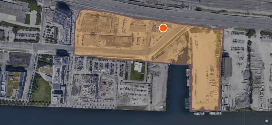
    Here is the extent of “Quayside” along the waterfront. The current land use permissions allow for about 3 million square feet of space and towers as tall as 50 storeys.

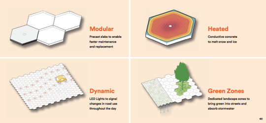
    Here is a paving system being explored for the area. It is modular. It may melt snow. And perhaps most interestingly, it would allow for dynamic changes in road use throughout the day. This sort of thing already happens to a lesser degree on streets like Jarvis. This technology could take that much further.

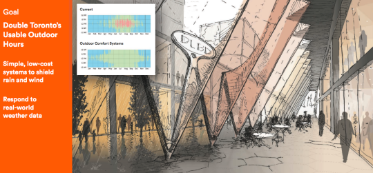
    One of their primary goals is to double Toronto’s usable outdoor hours. To do that, they are proposing simple weather shields (pictured below) and weather-responsive systems.

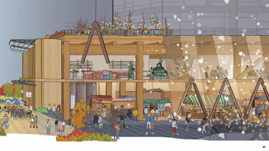
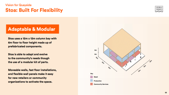
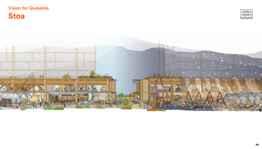
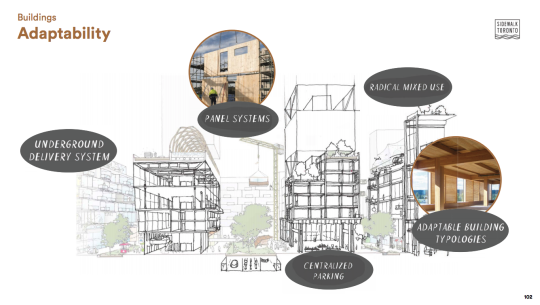
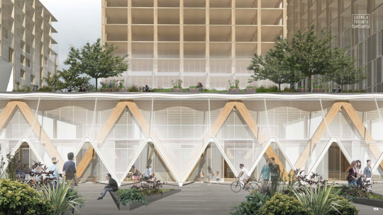
    They are spending a lot of time thinking about the ground floor of buildings, which they are calling Stoa. The idea is to create flexible and porous spaces that respond quickly to changing needs and that integrate more seamlessly with the surrounding public realm.

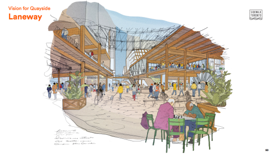
    There’s a lot on the potential hierarchy of the street network and how each will function for transit, conventional cars, AVs, cyclists, pedestrians, and so on. I was happy to see “laneways” as a core part of the pedestrian network. They are designed for walking speeds. Access would be restricted for things that move too quickly.

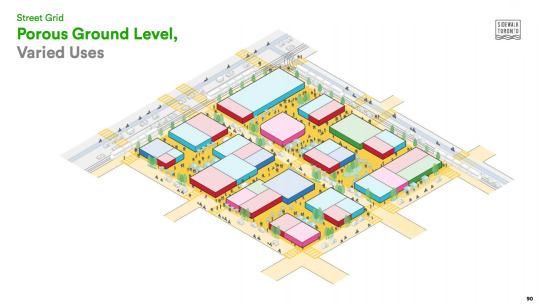
    This image ties in the street grid and Stoa.

    Finally, the goal is to build the neighborhood entirely out of timber, and more specifically, Canadian timber. If they follow through on this, I think it would really push adoption of this material forward in the city.

    I would encourage you to check out the full package, which you can do here. I can’t wait for these projects to get underway along Toronto’s waterfront.