Daily insights for city builders, delivered every morning at 6 AM ET. I’m Brandon Donnelly — a Toronto-based real estate developer and founder of Globizen. I’ve been writing here since 2013.

Tag: seattle

  • What is an urbanist?

    Cities are in vogue. And that has brought about buzzwords like urbanism, tactical urbanism, urbanist, and the list goes. But what exactly does it mean to be an urbanist?

    If you look it up in the dictionary, you’ll likely get something along the lines of: someone who is a specialist in city planning. But I bet that there are many people out there who would self-identity as being an urbanist, but who would also not consider themselves specialists in the field.

    The term has evolved to imply other things.

    To this end, Scott Bonjukian (over at The Urbanist) recently wrote a good piece called, Why I call myself an urbanist. And in it he offered up this definition from the former mayor of Seattle, Michael McGinn:

    “At the core, urbanists want more people living in cities, so they support more urban housing of all types. They prioritize walking, biking and transit, and support a high quality shared public realm. Parks, nightlife, theaters, transit and taxis can replace backyards, TV rooms and private cars. That way we can live well with less stuff, sprawl and pollution.

    I’ll go a little further, and say urbanists prefer bottom up, granular, and seemingly chaotic innovation to top-down planning and mega-projects. Think the “Main Street” of neighborhoods with food trucks and lots of little stores, as opposed to tax-subsidized big box stores with legally required massive parking lots. Bike lanes, crosswalks and plazas instead of public garages and new highways.

    Urbanists believe that mixing people and ideas creates wealth in a city. Why else would people choose to live so close to each other? Cities, therefore, should be open to people of every background, ethnicity, race and class to maximize the potential from our human capital.”

    Scott added that most urbanists are probably also environmentalists on some level, and I can certainly see where he’s coming from with that. Regardless, I think the above definition is pretty apt.

    But if you unpack some of the points, this definition raises some interesting questions. For instance, take the first line around supporting housing of all types. 

    This could mean that even if you lived in an inner city transit-served single family neighborhood, but you didn’t support alternate housing types such as duplexes, triplexes, accessory dwelling units and/or laneway houses, then you might not be a true urbanist. You would rather homogeneity over a “chaotic” mix of housing types. And I can certainly think of inner city neighborhoods in Toronto that have fought against “monstrous” duplexes. 

    So I would be curious to hear your thoughts on the above definition of urbanist. Do you agree or disagree? Is there anything you would add or take away? Are you an urbanist? Let us know in the comment section below.
  • Urban population densities, compared

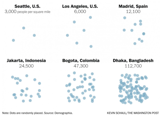
    Earlier this month The Washington Post published an article called, There’s no such thing as a city that has run out of room.

    And what it was really about was that when we say there’s no more room (I guess people are saying this), we are really saying that we just don’t want to allow anyone else to become our neighbor. Because the reality is that urban population densities vary widely around the world. So how can you really call a place full?

    I’m not sure I feel this pain point as much as the author, but I always find population densities to be a fascinating topic. And accompanying the article was a tool – using data from Demographia – that allowed you to compare the population densities of various cities.

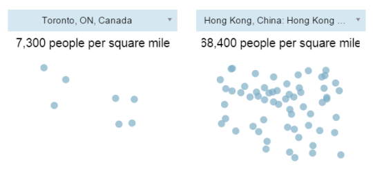
    Here are are two scenarios I ran:

    It’s important to keep in mind that these numbers are averages for the entire economically contiguous region. So it tells you nothing about the potential spikiness of certain areas. That’s why the population density of New York (which includes portions of New Jersey and Connecticut) probably seems low to you.

    Still, it’s fascinating to see how extreme some cities – including some first world cities like Hong Kong – can be. Clearly many cities have a lot of room to become a lot more dense. And I think that would be a good thing.

  • Why can’t cities reach equilibrium?

    The October issue of The New Yorker has an interesting piece called: Naked Cities – The death and life of urban America.

    I find the article ends up rambling a bit, but I like the idea presented right at the beginning. The idea that cities can never really find equilibrium. They’re either dying, or victims of their own success.

    Here’s that paragraph:

    Cities can’t win. When they do well, people resent them as citadels of inequality; when they do badly, they are cesspools of hopelessness. In the seventies and eighties, the seemingly permanent urban crisis became the verdict that American civilization had passed on itself. Forty years later, cities mostly thrive, crime has been in vertiginous decline, the young cluster together in old neighborhoods, drinking more espresso per capita in Seattle than in Naples, while in San Francisco the demand for inner-city housing is so keen that one-bedroom apartments become scenes of civic conflict—and so big cities turn into hateful centers of self-absorbed privilege. We oscillate between “Taxi Driver” and “The Bonfire of the Vanities” without arriving at a stable picture of something in between.

    I like this because there’s truth to it. But at the end of day, this is just one of the many challenges facing great city building. 

    To solve the problem of affordable housing you could just be a city in decline. But that’s not much fun. So the better option, however difficult it may be, is to figure out how to manage the negative externalities associated with winning.

  • What food is your city famous for?

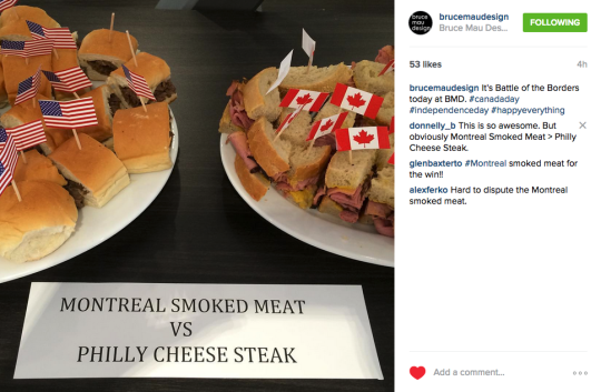
    Yesterday I came across the above Instagram post by Bruce Mau Design, which pitted the Philadelphia Cheese Steak sandwich against the Montreal Smoked Meat sandwich in a “battle of borders.” It was to celebrate both Canada Day and American Independence Day.

    I thought this was an awesome idea, so I tweeted out the photo. Then Daniel Kay Hertz – who is a Senior Fellow at City Observatory and from Chicago – asked me: “Is there a Toronto equivalent?

    And that got me thinking. 

    Montreal has smoked meat, bagels, and poutine. Philly has the cheese steak. Chicago has deep dish pizza. Quebec City has maple sugar and tourtiere (a kind of meat pie). New Orleans has po’boy sandwiches. Boston has clam chowder. Austin has tacos. Seattle has crab. And the list goes on.

    But what is the quintessentially Toronto dish? Asian fusion food? Peameal bacon sandwiches from the St. Lawrence Market? I really don’t know. So I think we should decide on one right now. Think of it as an exercise in city branding.

    Leave your suggestion in the comments below and we’ll have a vote.

  • Ace Hotel coming to Toronto’s Fashion District

    https://500px.com/embed.js

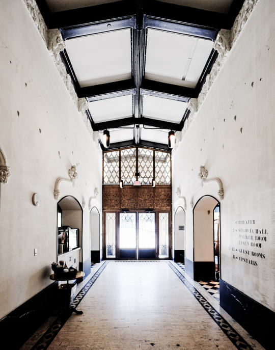
    The word on the street right now is that Ace Hotel will be opening up a location in Toronto’s Fashion District at 51 Camden Street

    Unlike its other outposts around the world, which entailed the renovation of a historic building, this one will be a new build. And according to HotelChatter, Shim-Sutcliffe Architects have been retained for the project.

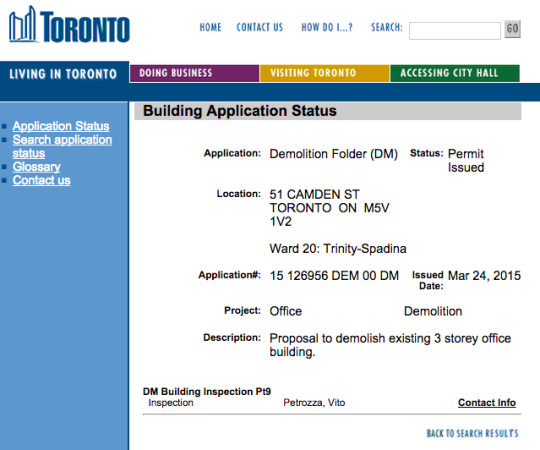
    Already a demolition permit has been issued for the existing 3 storey office building:

    image

    For those of you who may not be familiar with the Ace Hotel brand, the first hotel opened in Portland in 1999 when 3 friends transformed a halfway house into an affordable hotel for creative types. 

    Since then, the hotel has expanded to New York, Los Angeles, Seattle, Palm Springs, as well as many other cities, and has become a kind of cultural institution for the creative class.

    I’m excited that they have (allegedly) picked Toronto for their next property and I’m excited that Shim-Sutcliffe will be (supposedly) designing it.

  • The new Toronto 2030 District

    Photograph Financial District, Downtown Toronto, Canada by Yeonju SEONG on 500px

    Image: Financial District, Downtown Toronto, Canada by Yeonju SEONG on 500px

    Today I learned about something new called 2030 Districts. They are: “designated urban areas committed to meeting the energy, water, and transportation emissions reduction targets of the 2030 Challenge for Planning.”

    Toronto’s new 2030 District is downtown, which is bound by the lake in the south, Bathurst Street in the west, Dupont Street and Rosedale Valley in the north, and the Don Valley in the east. 

    It’s the first district outside of the US. The other established districts are in Seattle, Pittsburgh, Los Angeles, Denver, Stamford, San Francisco, and Dallas.

    The goals for Toronto’s district are as follows (quoted from 2030 Districts):

    • To cut district-wide emissions in half, including zero-emissions from new buildings by 2030.
    • Support a better understanding of where and why energy use, water use, and GHG emissions occur across the District.
    • Work in partnership with building owners, service providers and conservation groups to accelerate the adoption of best practices for building design and management.
    • Facilitate broad stakeholder dialogues to uncover and overcome systemic barriers to long term reductions in energy use, water use and GHG emissions.

    I’m looking forward to following and learning more about this initiative. I think many of us can agree that producing less, not more, GHG emissions in the future would be preferable. And we know that the bulk of it comes from both buildings and transportation.

  • Urban Engines launches app

    [youtube https://www.youtube.com/watch?v=FZ8ODREybcs?rel=0]

    About 9 months ago I wrote about a new startup called Urban Engines that was trying to improve urban mobility by using big data to optimize transit usage. 

    Last Tuesday the app launched in 10 cities across North America. So if you’re in Boston, Chicago, Los Angeles, New York, Portland, Seattle, San Francisco, Toronto, Vancouver, or Washington D.C., you can go ahead and download it right now.

    The biggest “wow factor” is probably the augmented reality feature that allows you to hold your phone up and see transit information overlaid on top of the street in front of you.

    But more fundamentally, the real potential lies in the platform’s ability to collect data on the way people move in cities and on how transit lines are performing, so that it can be fed back to improve overall efficiency.

    That’s why the company is also working with cities to give them 24/7 analytics and reporting on how every bus, car, and train is performing in their networks.

    My hope is that with better data at our disposal, we’ll be able to elevate the discussions around transit and transit planning. Without great data, it’s too easy for these discussion to become political.

  • Laneway summit post-mortem

    image

    Last night was The Laneway Project’s inaugural summit here in Toronto. And I think it was a huge success. This is what the crowd looked like (don’t forget to check the upstairs balcony area):

    //platform.twitter.com/widgets.js

    Over 350 people showed up to fill The Great Hall at Queen West and Dovercourt. It was absolutely incredible. To be honest, I initially thought that it would end up as a small group of city geeks. I mean, it was a summit to effectively talk about back alleys.

    But it turns out that there are a ton of people in this city who are passionate about rethinking our urban fabric and finding new uses for these underutilized public spaces. And that’s both really encouraging and exciting. Many thanks to everyone who came out!

    The Laneway Project team did an incredible job spreading awareness and, given the success of this initial summit, I can only imagine where this initiative will end up in the future. So a big congratulations to Mackenzie Keast, Ariana Cancelli, and Michelle Senayah for making this happen.

    I’m not sure if the event was filmed or not, but hopefully it was and it’ll be made available online. But in the event that it wasn’t, I did want to share one question that the panel got during the Q&A session after our presentations.

    The comment made was basically that Toronto will never be Sydney, Melbourne, or Seattle when it comes to our laneways. They have a temperate climate and we don’t. So while it’s nice to show great pictures of their laneways, it’s just not going to happen here.

    And that really pissed me off.

    So I responded by saying that I disagree. Saying that we’ll never be Sydney or Seattle is capitulating. There are many months of the year where it’s beautiful outside in Toronto, so just because we have a winter doesn’t mean we should throw our hands up in the air and give up.

    I then went on to argue that the fact that we have a “shorter season” should be all the more reason that we need fantastic outdoor and public spaces. For the months of the year where it’s beautiful outside, we should be maximizing our enjoyment!

    I hope many of you agree as well. Happy Friday all 🙂

  • Top 10 (US) cities for young smart people

    image

    I’m always on the lookout for great websites and communities dedicated to cities. And today, thanks to a friend of mine, I found a new one called City Observatory. It’s my new favorite site for city geeks.

    They describe themselves as a “data-driven platform for sharing, analyzing and discussing the success of cities.” As soon as I read that, I immediately subscribed. I’m a big believer in using data to elevate the discussions happening around our cities and to cut through the bullshit.

    I’m looking forward to digging into more of their articles, but I did already take a look at the first report they published, which is called: “The Young and Restless and the Nation’s Cities”. Click here to download the PDF.

    What the report talks about is a demographic group that they refer to as “Young and Restless”, and which they define as being 25-34 years old and having a 4-year degree. And they focus on this group because they see it as critical to driving local economic development.

    They’re the next generation who are going to start those companies and drive growth and innovation. And since the data shows that as people age, they become less willing to relocate (which intuitively makes sense), cities today are quickly realizing that they need to capture this group of smart people while they’re still restless (i.e. mobile).

    So if this is important, which cities (in the US) are winning right now? Here are the top 10 cities via City Observatory:

    1. Washington D.C. 8.1%
    2. San Francisco 7.6%
    3. Boston/Cambridge 7.6%
    4. San Jose 7.5%
    5. Denver 7.5%
    6. Austin 7.0%
    7. New York 6.6%
    8. Minneapolis 6.6%
    9. Raleigh 6.5%
    10. Seattle 6.1%

    The percentage represents the portion of the population that’s 25-34 years old and has a 4-year degree. I’ve just listed the cities here, but in reality they reference the entire metro areas.

    Do any of the cities on this list surprise you? None are surprises for me. It’s more or less what I would have expected to see, except maybe for the absence of Chicago (it’s 12th according to this ranking).

    Is your city doing enough to capture this group?

    Image: Flickr

  • Seattle’s first protected bike lane makes a quick adjustment

    Seattle recently installed its first protected downtown bike lane on Second Avenue. Here’s a short video of it in action (pay attention to the signalling setup and the pedestrians that walk into the bike lanes). Click here if you can’t see the video below.

    [youtube https://www.youtube.com/watch?v=x2iQCCHlR0s?rel=0]

    Shortly after it opened, they quickly discovered that the left green arrow and solid green circle (shown above) were confusing drivers. The intent was for the left green arrow to signal that you could turn and for the solid circle to signal that you could drive straight ahead.

    But even with the accompanying sign, drivers kept getting confused and thought a green circle meant you could go wherever you want.

    So the Seattle Department of Transportation quickly adjusted and changed the green circle to a north arrow. And it seems to have fixed the problem. I think it goes to show how important the details can be with these things.