Daily insights for city builders, delivered every morning at 6 AM ET. I’m Brandon Donnelly — a Toronto-based real estate developer and founder of Globizen. I’ve been writing here since 2013.

Tag: new york

  • Mapping where people run

    I’ve been meaning to write this post for about a week now. I stumbled upon a set of maps via FlowingData that used public running data to plot where people run in various cities around the world. And since I love maps, I couldn’t resist.

    Here’s Toronto:

    Here’s New York:

    Here’s San Francisco:

    And here’s Philadelphia:

    For the full set of maps, click here.

    What’s interesting is how people tend to gravitate towards the water rather than the parks. In the case of Toronto, High Park is barely touched, which may have something to do with the fact that it’s too far from downtown. The data could also be skewed based on the type of people who make their running data available and where they happen to live.

    Either way, a neat set of maps.

  • Invest in whatever China blocks

    Last weekend I posted a poll asking readers what they think the “capital of the world” will be in 2050. It was really the 2nd half of a two part poll. The first one asked what people think the capital of the world is today. And the majority of people said New York.

    While New York still came out on top in the 2nd poll, the most notable difference is the rise of Chinese cities. Behind New York is Shanghai, Hong Kong and Beijing. And in a way, this order makes sense to me. China would like to see Shanghai on top of Hong Kong, because it’s perceived as being more Chinese (Hong Kong is still too British). But both are still more economically important than Beijing.

    Still, my own belief is that China is going to need to go through some structural changes before its cities really have a chance of dethroning New York (or London, depending on your vote in the first poll). And I think it has to do with openness, transparency and freedom. Fred Wilson probably put it best when he said to basically invest in whatever China blocks:

    As our [Bitcoin] panel was winding down, Superintendant Lawsky asked what countries were doing it right. I didn’t answer that question but instead decided to talk about one that isn’t doing it right and brought up China and noted that a fantastic investment strategy would be to have invested in every Internet service that China has blocked. My point being that the services China likes to block are the really important ones that have been built on the Internet.

    He then goes on to say that he believes there’s a strong correlation between innovation and freedom. And I would agree. So until China stops blocking the innovation that is likely going to drive the world forward, I think it’s going to struggle to assume a true leadership position.

    What are your thoughts?

  • Keeping our momentum

    This morning Kevin Marshall tweeted me a link to a blog post by Andy Weissman (partner at Union Square Ventures in New York). The post is about how small things matter—even small words.

    He starts by talking about a new sidewalk extension and curb cut at 86th Street and 3rd Avenue in Manhattan. This may seem like a pretty banal thing to talk about, but it’s in support of his argument that small things—like even a curb cut—can be used to solve bigger problems. In this case, the intersection was a dangerous one because of poor pedestrian visibility.

    But what I really like is how he describes the pulse of New York:

    “The rhythm of NYC is such that we need to keep moving and in motion; as a result, waiting to cross a street by standing at the curb is not enough, we must walk into the street to get going or keep our momentum.”

    This is great and it’s bang on. People in New York don’t stand at the curb waiting for the light to change. They impatiently push onto the street and wait for the first opportunity to cross. This may seem like a small tendency, but I think it speaks volumes about the character of New York.

    People in Toronto generally don’t do this.

    They (not me) wait patiently at the street corner even if there aren’t any cars coming. Why? Think about this the next time you’re standing on guard at the crosswalk. Don’t lose the momentum. The world rewards those who poke the box and keep moving.

  • How Bloomberg transformed the streets of New York

    Here’s a great video by Streetfilms that shows the incredible transformation of New York’s public realm during the Bloomberg administration. I found it via The Urbanophile blog. It’s about 5 minutes long.

    Video Description: “There’s nothing more dramatic than looking back five or ten years at Streetfilms footage to see how much the streets of New York City have changed. In this wonderful montage, check out the incredible changes at Times Square, Herald Square, the Brooklyn waterfront, and many other places that outgoing NYC DOT Commissioner Janette Sadik-Khan and her staff have intrepidly transformed.”

    It just goes to show what can be accomplished with the right leader and political will. I wish we (Toronto) had a mayor who understood the value of beautiful public spaces and bike lanes. It’s unfortunate that these things often become attached to political orientation. This shouldn’t be the case. It’s just good city building.

  • Interactive map of carbon footprints across America

    Atlantic Cities recently published an article called, “Beefing Up Population Density Won’t Curb Greenhouse Gas Emissions.” And in it, they link to a really neat interactive map created at UC Berkeley that outlines the carbon emissions of nearly every zip code in America (2013 numbers). 

    Not surprisingly, it shows that urban folk generally have a much smaller carbon footprint as compared to suburbanites. Here’s what New York City looks like (green is lower carbon emissions and red is higher):

    image

    But the article also goes on to say that the solution is not to work towards increasing population densities in either urban centers or suburbs. And that, in fact, efforts to increase population densities in the suburbs would only make things worse—emission levels have been shown to only go up and then new suburbs end up getting formed around the intensified ones.

    I understand the last point about endless suburbs, but I don’t fully understand this recommendation. Do carbon emissions go up in the suburbs when population densities are increased because it still remains car dependent and so all you have is more people driving?

    Intuitively, it would seem that if more people stopped driving, shopped locally and lived in more compact spaces, carbon emissions would fall. But perhaps I’m missing something.

    If anyone has any insights on this topic, I would love to hear from you in the comment section below or on twitter.

  • SKATE city videos

    Two weeks ago I wrote a post called “Skateboarding and the city.” If you liked that post, I recommend you take a look at this 5 minute video called SKATE Toronto. It’s part of a series where local skateboarders provide a guided tour of their city.

    [youtube=http://www.youtube.com/watch?v=SEb4QvJzFVU&w=560&h=315]

    You’ll find similar videos for New York, Los Angeles, Miami, Philadelphia, Hong Kong, etc. What I like about them (other than the skating, of course) is that they clearly demonstrate the unique way in which skateboarders examine and engage with cities.

  • Toronto’s concession roads

    I’m late in writing this blog post because I was up in Collingwood for the day snowboarding. I’m exhausted, but I do have something to say.

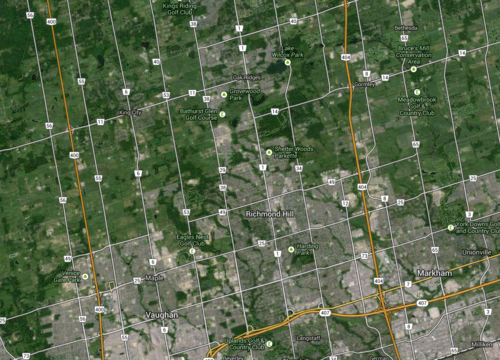
    One of the things I always find interesting when I’m driving north of the city is how far Toronto’s major north-south streets extend. Go out to Aurora or Newmarket and you’ll still come across many familiar faces such as Jane, Keele, Dufferin, Bathurst and Yonge Street. And the distance between each of them is exactly the same as it is in the city: 2 kilometres.

    This may not seem like much of a big deal, but have you ever wondered how this street grid was established?

    These streets are actually concession roads. And they were used to subdivide undeveloped land in Upper and Lower Canada into a grid that could then be further subdivided into farming lots. Each square of the grid is 2 km x 2 km, or 1,000 acres.

    Look at a map of the Greater Toronto Area and you’ll see it:

    image

    But what I find most intriguing about this grid system is that it was designed around farming—not our current use case. The intent was to further subdivide each 1,000 acre lot into smaller 100 acre farming lots. And these concession roads were for access—they weren’t city blocks.

    By comparison, there’s another city that’s famously run off a regular street grid. You may have heard of it. It’s called New York. And its street grid was established in the Commissioner’s Plan of 1811. Some even go so far as to say that it’s “the single most important document in New York’s development.” 

    But New York’s grid is much different than the one I’m talking about. Because of its smaller scale (20 blocks a mile going north-south), New York’s was decidedly urban. It was meant for city building.

    Now, in the case of Toronto, concession roads obviously never stopped us from developing a thriving city. We filled in each square to make them as urban as we needed them to be. But as planning ideals changed, so did the infilling of those squares. Our grid was flexible enough to accommodate everything from farm land to suburban subdivisions.

    But I can’t help but wonder how the Greater Toronto Area would have turned out had we, quite simply, chosen a different size of square. What if instead of 2 km x 2 km, we had made them 1 km x 1 km? Or what if we made them even smaller? What would the Toronto region look like today?

    Sometimes it may seem like a simple decision, but in reality the implications are huge.

  • Urbanization in the developing world

    A few days ago I asked a reader of this blog if there was anything, in particular, that she’d like to see more of on here. She responded by saying that she’d love to learn more about how other cities—outside of Toronto—are managing urbanization, as well as how we shape cities and cities shape us.

    It’s an interesting and important question because, frankly, the challenges are greater outside of Toronto. One of the stats that often gets cited here in the media is how the Greater Toronto Area gets approximately 100,000 new immigrants every year. This doesn’t include domestic migration though, so I would assume that our total number is even greater.

    But if we stick with 100,000 for now, it means the GTA receives about 11.4 new immigrants every hour (100,000 people / 8,765 hours in a year). Lagos, Nigeria, on the other hand, receives between 50-60 new people every hour. In fact, it’s predicted to be 7th fastest growing city in the world between now and 2020. 

    If you take a look at the complete list of the world’s fastest growing cities (all estimates, of course), you’ll likely notice that the vast majority of the cities are in the developing world. And that’s really the challenge. The world is rapidly urbanizing and becoming the most urban it’s ever been, but the changes are the greatest outside of developed nations. This poses entirely unique challenges.

    Of the kinds of cities I’m talking about, I’m most familiar with Dhaka, Bangladesh. In my last year at Penn, I was part of a studio led by KieranTimberlake Architects that focused on water and housing issues in that city. It was a partnership with the University of Dhaka. We spent roughly 2 weeks there and it was an eye opening experience.

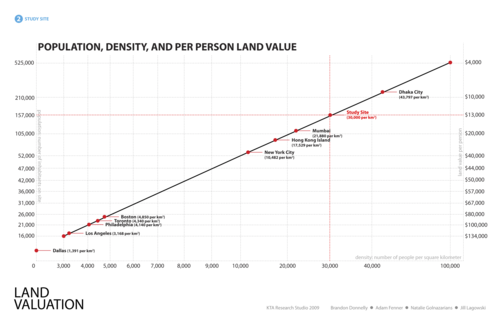
    Here’s a telling slide from our final presentation:
    image

    What we were trying to do with this chart was compare population and per person land value for our development site according to various city types. In other words, we were essentially asking: If we were to build out our proposed site in the same way, as say, Dallas, Los Angeles, Hong Kong, or what is typical for Dhaka, how many people could we fit and what would be the resulting per person land value?

    I don’t remember where we got the land value figures from, but we were trying to be cognizant of the fact that every city requires a unique solution. Using the same per person land values in Dhaka as in Dallas would be unimaginable because Dhaka has over 40,000 people per square kilometre (top right on the diagonal line above) and Dallas has under 1,400 per square kilometre (bottom left on the diagonal line above).

    The challenges of urbanization in the developing world are profound, particularly in places like Dhaka where most of the city is subject to severe annual floods. By some estimates, 18% of the city’s land area gets flooded every year—talk about adding another layer of city building complexity.

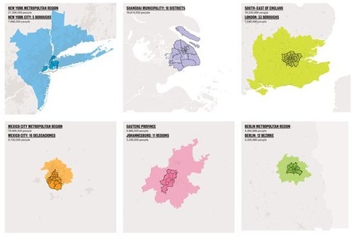
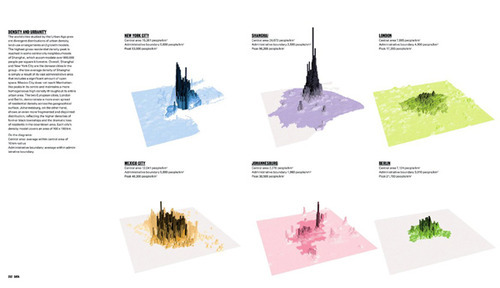
    We didn’t solve all of the problems in that studio and we’re not going to do it here, but I do think it’s important to fully understand the problem. One of my favorite books on cities is called “The Endless City.” It examines New York, Shanghai, London, Mexico City, Johannesburg and Berlin, and has a ton of great data and diagrams.

    Here are a two that outline densities and land use patterns for the above 6 cities (same order starting on the top left):
    image

    image

    If you’re interested in cities, it’s definitely worth having it on your coffee table. And fitting to @PhatNancy’s tweet, ”The Endless City doesn’t just show how cities are changing but also how they are changing us.

  • BlackBerry started our forest

    A friend of mine posted this article on my Facebook wall yesterday: “A Snowier Silicon Valley in BlackBerry’s Backyard.

    It essentially talks about the fact that despite the rapid decline of BlackBerry (it just reported $4.4 billion in losses), the Kitchener-Waterloo region is thriving. Many companies—both local and international, such as Google and Motorola, Square, Desire2Learn, Kik and others—have all hung their shingle in the area. 

    Part of this certainly has to do with the University of Waterloo, but much of it also has to do with the legacy of BlackBerry. In fact, you could argue that BlackBerry (formerly Research in Motion) is what started at all.

    In reading the New York Times article I was reminded of a post that Fred Wilson wrote last year called, “The Darwinian Evolution of Startup Hubs.” It’s a great post. In it he talks about how he looks for the company that gave birth to the hub. In Silicon Valley he argues that it was Fairchild Semiconductor and in New York it was Doubleclick.

    Once started, he likens the hub to a growing forest. The big trees (mature companies) start dropping seeds and new trees then start to grow (more startup companies). This is important, because it kick-starts a non-linear cycle of entrepreneurial growth.

    Here’s how he maps out Silicon Valley:

    “In my mental model of Silicon Valley, the first “tree” was Fairchild Semiconductor (founded in 1957) which begat Intel (founded 1968) which begat Apple (1976) and Oracle (1977), which begat Sun (1982), Silicon Graphics (1981), and Cisco (1984) which begat Siebel (1993) and Netscape (1994), which begat Yahoo! (1995) and eBay (1995), which begat Google (1998) and PayPal (1998), which begat YouTube (2005), Facebook (2004), and LinkedIn (2003) which begat Twitter (2006) and Zynga (2007), which begat Square (2010), Dropbox (2008), and many more.”

    Using this logic, Fred Wilson argues that Silicon Valley is about 10 cycles in and New York is at about 2. So what about Kitchener-Waterloo? Well if you buy into the argument that BlackBerry is what started it all, we’re really only into our first cycle. BlackBerry created a lot of wealth and talent, and now it’s being deployed into local startups. Our forest has begun.

    Part of me worries, though, if Kitchener-Waterloo is the right place for a startup hub over the long term. Sure it has the University of Waterloo, but does young talent want to be there? At about 320,000 people, it’s no San Francisco, New York or Toronto. And we’re already seeing a significant pull towards urban centers.

    But let’s look at it from the perspective of Southern Ontario as a whole. We’re at a critical moment in our evolution. The mother tree has caught a disease and it’s starting to take its toll. It may be able to fight it off, but right now it’s not looking promising. Thankfully, there are many young trees sprouting up to replace it. But we’re going to need to take special care of them, because they’re probably our best shot at creating our own thriving forest.

  • Am I supposed to like this city?

    Marketer Seth Godin just wrote a typically short blog post called, “Am I supposed to like this?

    In it he talks about the fact that we are, for example, more likely to enjoy the food at a fancy restaurant. And we’re also more likely to enjoy a bottle of wine if it’s expensive or if we believe it comes from some desirable wine region and it’s supposed to be good (you can even just switch the bottle).

    He then sums up this idea in one line that I really like: “Judgments happen long before we think they do.”

    Now, I’ve thought about this same idea with respect to cities. Take New York, for example. New York is famous. If I had to pick a capital for the world, it would probably be New York.

    You watch it in movies and shows (even if it’s actually filmed in Toronto, Chicago or some other stand in). We read about it. We hear about it. We generally form judgments without the actual experiences. That builds brand equity. We’re supposed to like New York. Sex and the City told us so. And that makes it all that much better when we eventually get there.

    Of course, it’s a bit of a catch-22. You have to be an awesome city for people to want to make movies and songs about you. But in this era of global connectedness, I think everyone, from citizens to economic development agencies, can fake it until that city makes it by investing in “supposed to.” Am I supposed to like this city?