Daily insights for city builders, delivered every morning at 6 AM ET. I’m Brandon Donnelly — a Toronto-based real estate developer and founder of Globizen. I’ve been writing here since 2013.

Tag: new york

  • The middle class myth — a conversation with Marc Andreessen

    New York Magazine recently published a really great conversation between Marc Andreessen and Kevin Rose. Marc cofounded Netscape way back when, and now runs a venture capital firm.

    In addition to technology, the conversation touches on a bunch of different topics such as why it’s beneficial to be an optimist and why change can be difficult for people to accept.

    But they also hit on a number of broader economic shifts, such as the replacement of labor by machines, and the rise and decline of industrial production in the US. Here’s a snippet on that latter point:

    You’ve described the middle class of the 20th century as a myth.

    There are two middle classes. There’s the historical middle class—which is the bourgeoisie—starting in the, like, 1600s. This was the businesspeople and the traders, the merchants, the butcher, the baker, the general-store manager, the guy who was going off to China to go get silk and bring it back. Businesspeople.

    But in the 1940s something really significant happened, which is we bombed the rest of the industrialized world. And so the industrial base of Germany was obliterated. Japan was reduced to rubble. The rest of Continental Europe was bombed. England was bombed. The industrial base of the world was bombed. The one major industrial country that wasn’t bombed was the United States. So the United States became the monopoly producer of industrial goods.

    The army bombed the American middle class into existence?

    It was an accident of history. We had a window of opportunity which we took full advantage of. We had this window from basically 1945 to 1966, 1968, in which we were basically running unopposed. In that window, all kinds of wonderful things happened. One of the things that happened was the rise of this new idea of the middle class, which there was no historical precedent for, which was college-level wages for high-school-level education. As long as there’s no competition, it’s all well and good. The minute the Japanese show up, the minute the Germans show up, it just all falls apart.

    Click here for the full conversation. It’s an interesting read.
  • The story of two urban giants

    This morning I stumbled upon an interesting documentary (via The Urbanophile) about two New York skyscrapers that were built in the 1930s as telecommunications buildings: the Western Union Building and the AT&T Long Lines Building. It’s fascinating to see how they have evolved along with technological change. Click here if you can’t see the video below. It’s only 8 minutes long.

    //player.vimeo.com/video/97945495

  • What the largest real estate development project in the United States looks like

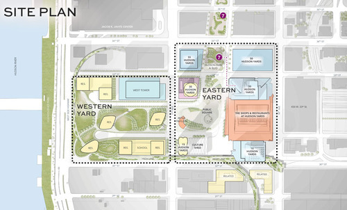
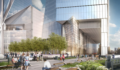
    Urban Land Magazine recently published an interesting article on the Hudson Yards project in New York, which is the largest private real estate development project ever undertaken in the United States. Click here for the article. Thanks to my friend Evan Schlecker for passing it along. It’s a good read.

    The project is being co-developed by Related out of New York and Oxford Properties out of Toronto, and when it’s all said and done, it’ll be over 17 million square feet of commercial and residential space. It’s a $20 billion development project. 

    But beyond just being massive and epic, there are a bunch of other things that make this project unique. You can read about them all in Urban Land, but I’d like to share a few snippets with you all here:

    The first is about the project’s placement on top of a rail yard:

    In order to make use of a site already occupied by a working rail yard—including more than 30 tracks for the Long Island Rail Road and three train tunnels, with a fourth under construction—most of the development will be built atop two steel-and-concrete platforms. That base, and the buildings on it, will be supported by hundreds of concrete-filled caissons, which will be drilled between the rail lines into the bedrock.

    Because the location of the tracks and tunnels limits the placement of caissons, only 38 percent of the site can be used to support buildings.

    The second is about the project’s use of technology:

    Beyond that, a vast number of sensors embedded in the site’s infrastructure will collect mountains of data on everything from temperature and air quality to pedestrian and vehicle traffic. That information, which will be scrutinized in real time by managers in an effort to fine-tune Hudson Yards’ operation, will also be shared with New York University (NYU) researchers, who will turn Hudson Yards into a laboratory for studying urban life and finding ways to improve its quality.

    And the last one is about how it interfaces with the High Line (click here if you don’t know what that is):

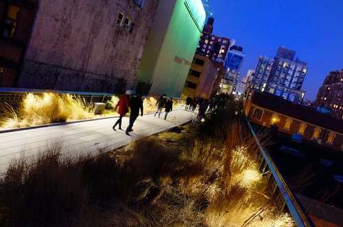
    Pedersen [of Kohn Pedersen Fox Associates] found an intriguing way to address the building’s surroundings. He allowed the High Line—a public park built on a historic freight rail line elevated above the West Side—to penetrate underneath the tower through a 60-foot-long (18.3 m) public passageway, so that the building will interact with the park and its visitors. Inside the building, a dramatic atrium “becomes the terminus of the High Line as it moves from south to north,” he says.

    So there are a lot of interesting and exciting things going on with this project. What’s amazing though is how “vertical” this community will be. You have rail lines below grade. Platforms on top. Retail at grade and across multiple levels. And an elevated linear park cutting through the buildings. Not every city can make this work. New York can.

    Images: Hudson Yards New York

  • Don’t forget that this is about people

    Yesterday I wrote about the High Line Park in New York and the tremendous success that it has seen since the first section opened in 2009. It attracts somewhere around 5 million visitors a year and is thought to be responsible for over $2 billion a year in economic activity.

    But the economic activity it’s generating and the future tax revenues it’s creating are really a byproduct of the fact that people, quite simply, love the High Line. It attracts people. And that reminded me of a short post I wrote earlier this year called: It’s all about people. Because if you think about it, that’s really the key metric for a lot of things in life and in business.

    When you build a park like the High Line in New York or Millennium Park in Chicago, you’re designing it to attract people. When you build a mall, you seek out anchor tenants, because you know they drive foot traffic. When you build a new neighborhood, you’re trying to create street life from scratch. When you run a bar, you want headcount. And when you build a web or mobile app (or write a blog for that matter), you want registered users and eyeballs on your platform.

    And you want these things because foot traffic, street life, eyeballs, impressions, users, and headcounts ultimately generate revenue. But here’s the thing: if you focus directly or too much on that end goal, you run the risk of missing an important step along the way, which is simply to delight real people.

    In his most recent essay, startup guru Paul Graham put it perfectly when he said:

    “The way to succeed in a startup is not to be an expert on startups, but to be an expert on your users and the problem you’re solving for them.

    He’s obviously talking about technology products, but the same could be said for parks, streets, malls, plazas, and so on. To design and build better cities, we need to be experts on people. And we need to create spaces and environments that people actually want to occupy. Spaces that improve people’s lives.

    Now, this may sound fairly obvious to some of you. But quite often I feel like we get sidetracked by things that don’t matter as much as people do.

    Image: Flickr

  • Learning from, but not copying, New York’s High Line

    image

    In 1980, the last train ran on an elevated corridor on the west side of Manhattan known as the High Line. Originally built in the 1930s, the trucking industry had made these trains obsolete and service was halted.

    At this point, neighboring property owners began to lobby for the demolition of the High Line, as they no doubt saw it as an opportunity to increase the value of their land holdings. But thanks to local residents – most notably a man by the name of Peter Obletz – the 1.45 mile-long elevated rail corridor was saved from demolition.

    In 1999, Joshua David and Robert Hammond then decided to form a non-profit with the goal of both preserving and reusing this unused rail corridor. The group was called Friends of the High Line.

    By the early 2000s, Friends of the High Line had successfully made an economic case for transforming the rail line into a public open space and things started moving forward. Initially, it was thought that a public park of this sorts would attract about 400,000 people annually and generate upwards of $286 million in new tax revenues over the following 2 decades (Globe and Mail).

    With these expectations in mind, construction on the new High Line Park began in 2006. The first section opened in 2009 – a decade after Friends of the High Line was formed. And the third, and last section, opened just two weekends ago at the end of September.

    Today the High Line Park attracts 5 million visitors a year and is believed to be directly responsible for about $2.2 billion in new economic activity. The increased tax revenues over the next 2 decades are expected to reach about $980 million. Without a doubt, the High Line has been a huge success. It has become the 2nd most visited cultural attraction in New York (Globe and Mail).

    Which is why every city now wants their own High Line. Philadelphia wants one. Chicago wants one. Mexico City wants one. Seoul wants one. And the list goes on. Here in Toronto, we’ve recently proposed one called the King High Line, which will connect the Liberty Village and West Queen West neighborhoods across a rail corridor.

    While I do believe that this is an important connectivity problem to be solved, I worry about how explicit the references are to the actual High Line. Even the street furniture is the same in their promotional video.

    I worry not only because it means we’re clearly taking on the role of follower, as opposed to leader, but because an elevated park isn’t going to work in all urban contexts the same way that the High Line worked in Chelsea. This is similar to how Frank Gehry can’t magically turn your city into the next Bilbao

    So while I have shown my support by becoming a “Friend of the King High Line” (and I would encourage you to do so as well), it’s important to keep in mind that the problems we’re trying to solve here aren’t necessarily the same ones that New York had to deal with.

    The High Line – from the start – was designed to have an intimate relationship with its surrounding buildings. The tracks rain directly through them so that the trains could easily load and unload their cargo – that was the whole point. So when the High Line was redone, all of a sudden these buildings were able to reconnect themselves to the park in a way that they were already accustomed to doing.

    But in Toronto’s situation, and perhaps in your city, that’s not the case. We’re talking about stitching together two completely disconnected neighborhoods. It’s a noble goal and certainly one that I wholeheartedly believe we should pursue. But I don’t think we should assume that it’s a problem that has already been completely solved for us.

    Image: Flickr

  • Assembled realities of the New York landscape

    New York photographer Jeff Chien-Hsing Liao has an upcoming solo exhibition at the Museum of the City of New York next month called Assembled Realities. I just heard about it through CityLab.

    Here’s a bit of background on his work:

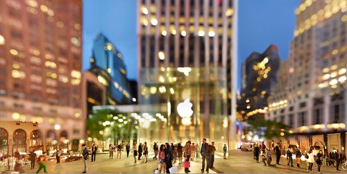
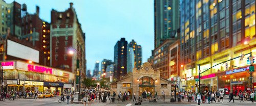
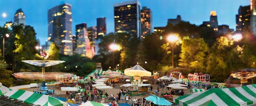
    Pushing the boundaries of traditional documentary photography, Liao (b. 1977) creates large-scale panoramas by combining multiple exposures of the same location taken over the course of several hours. The resulting composite photographs are often fantastical; complex, hyper-real views that no single shot—or the eye—could capture.

    And here’s two more of his photos:

    For higher resolution versions, click here.

    I love how his photos begin to distort reality and how they focus your attention – in many cases – on New York’s vibrant street life. I thought you might all enjoy them as well.

  • A walk down memory lane in the St. Lawrence Market

    I recently got lost looking through the Toronto Archives for old photos of my neighborhood. I’ve blogged about what the St. Lawrence Market neighborhood looked like in the 70s, but I wanted to go back even further. I wanted to see what exactly had been demolished and lost over the years.

    But by the end of it, I was just sad. As a lover of cities, it always makes me upset to see great buildings disappear. I think you too will be surprised at what I found.

    The following picture depicts the north side of Front Street East, about 2 blocks east of Yonge Street. I don’t know what year it is, but look at how stunning these buildings are. It looks like Soho, New York meets some glamorous European capital.

    Can you imagine what we could do with these buildings today?

    image

    If there’s any doubt in your mind that this is Toronto or that it’s Front Street East, take a look at the spire in the far left hand side of the picture. It belongs to the Toronto Board of Trade Building, which used to sit at the north east corner of Yonge Street and Front Street. When it was built in the late 1800s, it was considered one of the first “skyscrapers” in Toronto. It was demolished in the 1950s.

    Here’s a picture of the Board of Trade Building so that you can compare. Again, take a look at the spire.

    image

    For those of you who might not be familiar with the area, here’s a map to help you out. The Board of Trade Building is shown on the bottom left hand corner. And the buildings in the first picture are in the triangular land area between Wellington and Front.

    image

    Now, let’s fast forward to the late 1960s. Those same buildings shown in picture number one have been demolished and in their place is the following parking lot. It’s a bit less glamorous looking. There are still heritage buildings on the south side of Front Street, but the balance of the area seems to have been blown out. What a shame.

    image

    Finally, here’s an aerial view of the area. It’s also from the late 1960s or early 1970s. You can see the same triangular land area, with only the Flatiron Building still standing at the very tip of it.

    image

    Obviously the St. Lawrence Market has come a long way since the 70s. That triangular area has since become Berczy Park, which is actually in the midst of being completely revitalized, and all of those parking lots have been filled in. But I still can’t help but wonder what the neighborhood would be like today had we preserved all of those heritage buildings. 

    I think cities work best when you can figure out that delicate balance between preservation and progress. It’s not always the simplest approach, but as most things in life, the right decisions are often the toughest ones to make.

  • What should San Francisco do with the Tenderloin?

    image

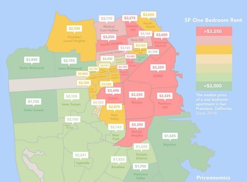
    Recently Priceonomics posted a piece on San Francisco’s “rent explosion.” In it, was the infographic above showing the median rental rate for a 1 bedroom apartment in the city. The most obvious takeaway is that San Francisco is real expensive. In the core of the city, you’re easily looking at $3,000 per month.

    That is with one exception: the Tenderloin (the green area just northwest of SOMA in downtown). The first time I ever visited San Francisco, I actually stayed on the outskirts of this area, which is a neighborhood well known for seediness, homelessness, crime, drug trade, strip clubs, and so on. And it was actually named after a similar neighborhood in New York that was also a center of vice in the late 19th and early 20th centuries.

    But when I saw this diagram, I immediately asked myself: How could it be that the Tenderloin was holding out so well against the forces of gentrification? How is this island of seediness being preserved in the center of downtown? Particularly in a city like San Francisco where there’s a perpetual housing supply shortage and lots of wealth. The Tenderloin has some of the lowest rents in the city.

    So I tweeted the good folks at Priceonomics and they responded with this article. It’s a few pages long, but the reasoning seems to come down to the following: active community groups that fought to keep developers out of the area (and that also own many of the buildings), downzoning, and a high percentage of rooming houses. According to that same article, the Tenderloin contains approximately 100 single room occupancy residential hotels (or SRO’s as they’re called). These were initially built to house the city’s transient and seasonal population after the great fire of 1906.

    So it would appear that there are some significant barriers to entry.

    But at the same time, it generally seems like a bad idea to concentrate poverty, homelessness, drug users, and so on. Interestingly enough, the article talks about how when the Bay Area’s transit system went on strike for a period of time, the supply of drugs actually dried up in the Tenderloin. This underscores how regional the drug business is, but also makes me think that dealers are almost surely benefiting from the clustering of their client base.

    In any event, this is a much larger problem than just a real estate development one. I don’t know what the solution should be, but I’m pretty sure that things are being made worse by concentrating everything in one neighborhood and by rising income inequality in the city. Inequality seems to lead to all kinds of negative externalities and, from my experience, mixed-income neighborhoods perform better than 100% poor ones.

  • Introducing: ATC city tees

    image

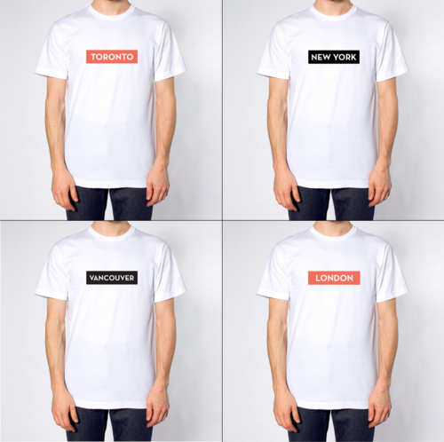
    I’ve just launched a set of city tees over at shopATC. To start, there are 4 cities (Toronto, New York, Vancouver, and London) and each one is available in either black or (ATC) orange. They’re printed on a super soft American Apparel tee and cost only $30 each. I picked the cities based on readership levels. I hope you like them.

  • What to do when a car is blocking your bike lane

    I was out for a bike ride last night and, on my way home, I decided to try out the new dedicated bike lane on Adelaide Street. Usually I would take King Street, but it was completely full because of Caribana parties.

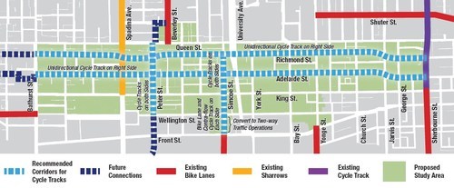
    For those of you who may not be aware, the city of Toronto is currently piloting two dedicated bike lanes on Adelaide Street and Richmond Street in the downtown core. Both streets are one-way and because the lanes were so big to begin with (highway-like spacing), I’m told that these new bike lanes didn’t even eat up a driving lane.

    Here’s a map of the pilot area:

    image

    Given that dedicated bike lanes are a scarce resource here in Toronto, I have to say that it was rather luxurious having my own piece of road. And because there’s no longer any fear of parked car doors swinging open, I was able to ride a lot faster than I normally would. 

    But as my friend Evgeny pointed out earlier this week, there’s a big difference between dedicated and grade separated bike lanes. Indeed, on my trip from Bathurst Street to Church Street last night, I encountered 3 cars parked in my lane.

    //platform.twitter.com/widgets.js

    So, I hope that these bike lanes become a permanent fixture downtown, but that the city makes them grade-separated. I’m sure people will use them. At the same time, I think they could also act as a catalyst for more pedestrian life along both of these streets.

    If you haven’t yet tried them out, I would encourage you to do so. The city is tracking usage and so you would be supporting the cause. And if there’s anybody parked in your lane, below is one way to handle it. It’s a video by Casey Neistat out of New York. If you can’t see it below, click here.

    [youtube https://www.youtube.com/watch?v=bzE-IMaegzQ?rel=0]