Daily insights for city builders, delivered every morning at 6 AM ET. I’m Brandon Donnelly — a Toronto-based real estate developer and founder of Globizen. I’ve been writing here since 2013.

Tag: new york

  • The global pyramid of wealth

    Every year the London-based property consultancy Knight Frank publishes something called The Wealth Report. And it’s one of those reports that I could go through for hours. 

    It includes a ton of really fascinating stats that speak volumes about where in the world wealth is being created and how it’s moving around. And of course there are a lot of connections between wealth, real estate, and city building.

    Below are 3 diagrams that really stood out for me in the 2015 version. 

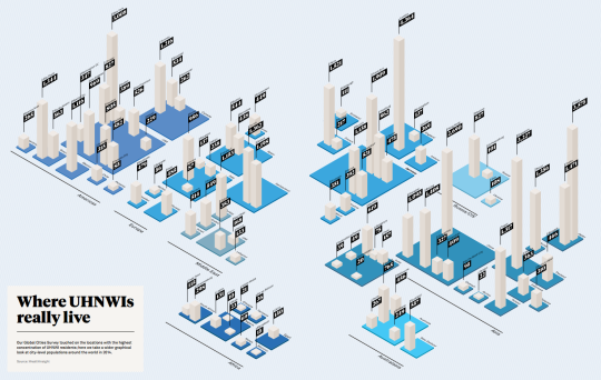
    The first diagram shows which cities have the most Ultra High Net Worth Individuals (UHNWIs). An UHNWI is defined as an individual with assets exceeding US$30 million, but excluding personal assets and property (such as one’s principal residence). Click here to see the full size image (I know the numbers are small).
    image

    Not surprisingly, London (4,364), Tokyo (3,575), Singapore (3,227), New York (3,008), and Hong Kong (2,690) are at the top of the list. But I was a little surprised – albeit happily surprised – to see Toronto (1,216) come in at #2 in North America, beating out Mexico City (1,116), Los Angeles (969), and Chicago (827). 

    The second diagram shows you how many square meters of luxury property (apartment) you can buy for US$1 million in a bunch of different cities around the world. 

    In Monaco (top end), that’ll buy you 17 square meters (183 square feet) and in Cape Town (bottom end), that’ll buy you 208 square meters (2,196 square feet).

    image

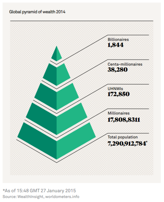
    The third and last diagram is what they call the global pyramid of wealth. It’s a pyramid of everyone in the world and then the number of millionaires, UHNWIs (see above), centa-millionaires, and billionaires. And if you do the math, the top of this pyramid comes nowhere close to 1% of the global population.
    image

    It’s fascinating (and exciting) to see where and how global wealth is concentrating. But it should also make you think about rising income inequality. I know it does for me.
  • Taller and skinnier

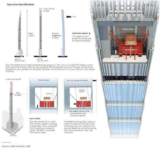
    Tall buildings will sway in the wind. And when they get taller and skinnier, the swaying becomes more pronounced.

    In seismically active cities, such as Tokyo and Taipei, “tuned mass dampeners” are often used near the top of tall buildings to offset the swaying caused by an earthquake.

    But tuned mass dampeners are also found in cities like New York, so that developers can build even taller and skinnier.

    Below is a diagram from the New York Times showing what one looks like and how it works. The example tower is 111 West 57th Street.

    Basically the masses are tuned to oscillate at a different frequency than the rest of the tower. So when the wind blows and the tower is moving one way, the weights are moving in the opposite direction and forcing the tower back towards some sort of equilibrium. 

    Neat. Structures was one of my favorite classes in architecture school.

  • New York’s 8-figure apartments

    Whenever you’re starting to feel like real estate prices in your city are getting out of hand, just turn your attention to New York. It’ll make you feel better.

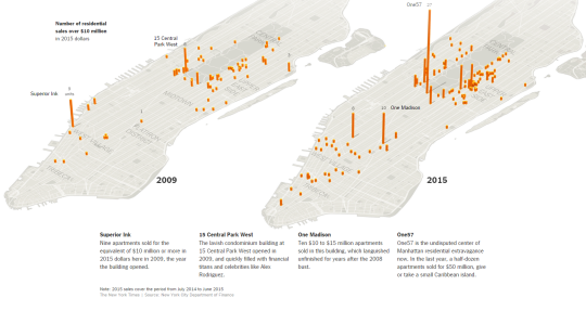
    The New York Times published an interactive overview of the Manhattan real estate market today. It was spurred on by the fact that the average residential sale price in Manhattan just hit $1.7 million (a new record) and that there’s a growing number of 8-figure apartments being bought up.

    Last year half a dozen apartments sold for more than $50 million in the One57 tower at 157 West 57th Street. (The New York Times calls this building the “undisputed center of Manhattan residential extravagance.”)

    Here’s one of their diagrams showing the number of residential sales over $10 million in 2009 and then in 2015:

    image

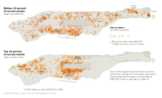
    And here’s another one of their diagrams showing the bottom and top 10% of the current market:

    image

    It’s interesting to see the clustering in certain areas and also the lack of clustering at the high end around the top of Central Park.

  • How immigration shaped Toronto and New York

    One of the things that Joe Berridge reminded me of in his talk yesterday, is that the story of Toronto is really the story of immigration. 

    In his words, Toronto has become the success story that it is precisely because we are good at taking in lots of immigrants and making them economically productive. 

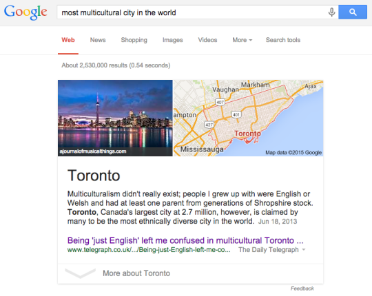
    Sure, there are many things that we could be doing better, but you don’t get to be the most multicultural city on the planet without doing a lot of things right. More than half of this city is now foreign born. The term “visible minority” is quickly expiring.

    image

    And more than anything else, this accomplishment is arguably what has allowed us to become the global city that we are. Click here for a fascinating chart from the Toronto Star that allows you to see the number and source of immigrants that have come to this city over the last half century.

    But of course, Toronto is not alone in this accomplishment.

    Urban economist Edward Glaeser wrote a great essay back in 2005 called Urban Colossus: Why is New York America’s Largest City? It’s an incredibly interesting read for those of you interested in cities and so I definitely recommend it.

    But the crux of his argument is that New York is the largest and most dominant city in America because of geography – specifically its deep harbor – and because of its success in manufacturing.

    What this meant is that New York became the center of shipping in the country and the point of entry for the majority of immigrants coming into the United States. But since transportation costs were still relatively high at the time, most immigrants arrived in New York and stayed in New York.

    Luckily, New York had a robust manufacturing economy – notably because of sugar refining, publishing and printing, and the garment industry. This allowed the waves of immigrants flooding into New York to become economically productive.

    From 1850 to 1920, the population of the New York grew about 800% from roughly 700,000 people to over 5.6 million people.

    So the moral of the story is simply that immigration has and will continue to play a pivotal role in the shaping of our cities. Canada has a sub-replacement fertility rate somewhere around 1.61 births per woman (2012). This is lower than that of United States, which is around 1.88 births per woman.

    That means that without immigration, we do not grow. We shrink. And that’s usually not a great thing for economies.

  • 7 ideas and lessons for global cities

    Today I had the pleasure of attending a really great talk by Joe Berridge (partner at the planning firm Urban Strategies) that was all about how Toronto can best maintain its position as a globally competitive city. 

    He went through 7 ideas/lessons. Though they were specifically aimed at Toronto, most of them could be applied to any city that’s concerned about its position on the global stage. They are:

    1. Invest in infrastructure, such as transit, airports, and so on. Sustainable funding and proper governance are critical. Transit planning in Toronto has become far too political and it’s crippling our city.
    2. Embrace Uber and get them using our Presto card so that it becomes a legitimate part of the city’s public transit network. Every city in the world is battling with Uber. Toronto has the opportunity to take a leadership position.
    3. Build a new convention centre and invest more in tourism and economic development. Berridge’s suggestion was something big at Ontario Place/Exhibition Place.
    4. Build new Universities to fuel the knowledge economy. See New York’s Cornell Tech campus as an example.
    5. Invest in infrastructure and institutions that turn research and development into businesses. Platforms like MaRS.
    6. Start thinking big. This was specifically geared towards Toronto, as his argument was that we do a lot of the small things right, but we’re missing out on the really big opportunities.
    7. Create Suburban Enterprise Zones to help drive employment outside of the core and along new transit corridors.

    Alongside these ideas and lessons, there was a fascinating sub-argument. And that is that Toronto is really an accidental global city. In other words, we didn’t set out to become a top 10 global city and one of the fastest growing cities in the developed world.

    But by getting a lot of things right – such as a high quality of life – and through a bit of luck – such as Montreal shooting itself in the foot – we somehow became one. But we absolutely shouldn’t take that for granted. There’s lots of work to be done.

  • On boulevards vs. freeways

    Toronto’s Director of Urban Design, Harold Madi, recently did a 20 tweet series on boulevards. And since today is Gardiner East day, it seems appropriate to share it with you all. Thanks to Shawn Micallef for using Storify to put it all together neatly. If you can’t see all the tweets below, click here.

  • The world’s top 10 cities for prime property

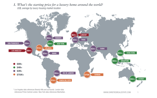
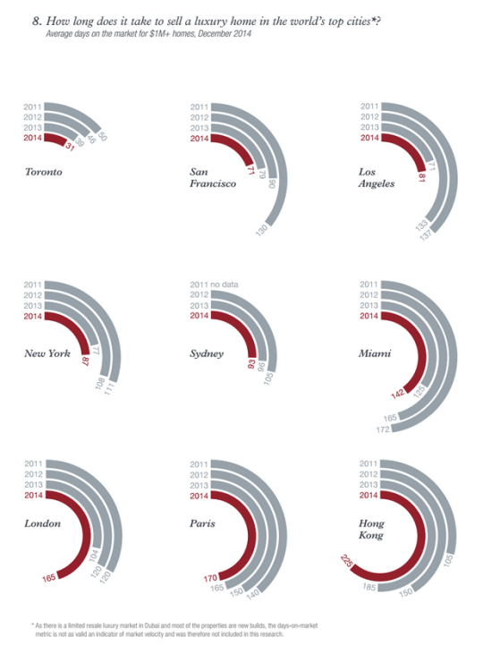
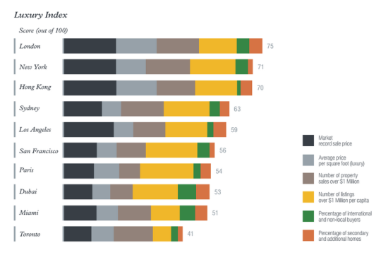
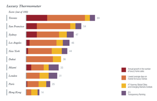
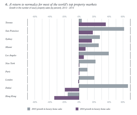
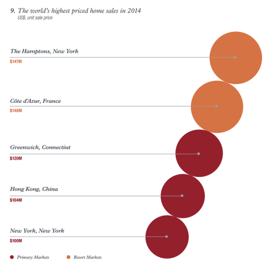
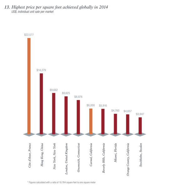
    This morning I read through a real estate report called Luxury Defined. It’s a look at the global luxury real estate market across “the world’s top 10 cities for prime property” and about 70 regional and resort destinations.

    It’s interesting to look at the trends and see how high-net-worth individuals (HNWIs) are choosing to allocate their funds in residential real estate. Here are some of the charts and diagrams that caught my eye as I was going through it (you may need to zoom your browser in):

    If you’d like to download the full report, click here. It’s free, but you’ll need to enter your name and email address.

  • W57 — A new hybrid building typology

    image

    We’ve been talking about a lot of heavy topics here on Architect This City lately. Everything from the contentious Gardiner Expressway East to minimum population densities to density creep. 

    So today I thought we could talk about something a bit more fun: architecture.

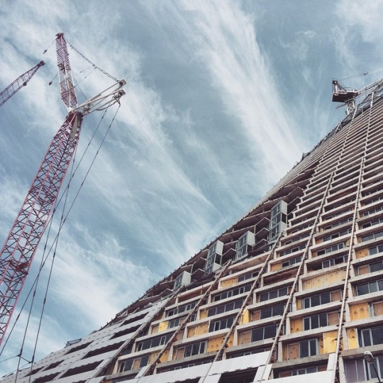
    When I was in New York last weekend, one of the buildings that was on my must-see list was the now under construction West 57th Street by Danish architect Bjarke Ingels. See photo above. (It also happens to be at the exact location where the West Side Highway transitions from elevated to surface boulevard.)

    This is supposedly the first North American project for Bjarke Ingels (he also has a project in Vancouver now). And if you’re a regular reader of this blog, you’ll know that I’m a fan of his work. His diagrams and storytelling ability were a big inspiration for me when I was in architecture school.

    The concept behind the project was to create a new hybrid building typology, one that is a cross between the typical European perimeter block building and the North American skyscraper. And the result is pretty wild.

    Here’s a video in case you aren’t familiar with the project. Click here if you can’t see it below.

    [youtube https://www.youtube.com/watch?v=_0JbTbOm_iQ?rel=0&w=560&h=315]

    I think it’s a really exciting project. What are your thoughts?

  • Scootering around New York City

    image

    I am writing this post on a Porter flight from New York back to Toronto.

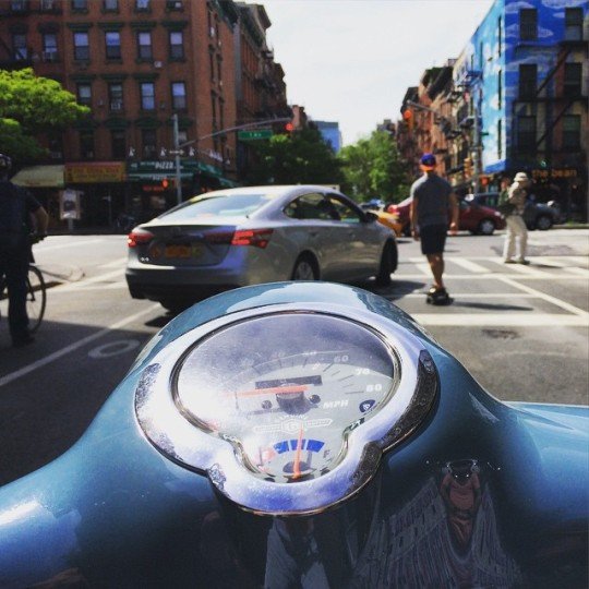
    For my last day in New York, my close friend and I rented scooters and rode all around Manhattan and Brooklyn. It was a great way to cover a lot of ground, but also a great way to still absorb the city. It’s harder to do the latter in a car and I never have any desire to drive in New York.

    Because the great thing about New York is that as a pedestrian you feel like you control the streets. When you’re waiting at a crosswalk, you’re never actually waiting. You walk off the sidewalk and onto the street so that you can assert yourself in front of the cars and wait for an opening. This serves to narrow the portion of road that the cars can actually drive on and reminds the drivers who is boss.

    At the same time, there are many instances throughout the city where New York has purposefully reallocated the space dedicated to pedestrians (and cyclists) and the space dedicated to cars. They’ve created new public spaces, widened the areas where people can walk, and seemingly blanketed the city with bike lanes. And that makes a lot of sense given that in many (most?) areas of the city, pedestrians greatly outnumber cars.

    So does that mean New York is at war with the car? (I’d be curious to know – in the comment section below – if those kinds of discussions take place in the city.)

    I suppose you could spin it that way. But New York also does things for cars. While riding around on the scooter today, I was so impressed by how well timed the streetlights were along the avenues. It made it incredibly easy to go downtown or uptown. In Toronto, I often feel like we time our lights to make driving as slow as possible.

    But make no mistake; New York is not a driving city. 

    New York is about walking, biking, taking transit, and hailing cabs. There is a reason they have the highest transit ridership in the US. The city is built for it. And unless driverless cars and ride sharing completely changes the equation, I will continue to believe that transit is the most efficient backbone for any big city.

  • Walking the West Side Highway

    image

    I am in New York this weekend. Every now and then I need to get my fix of this city. I just love it here.

    Given the debate that’s going on in Toronto right now about the elevated Gardiner Expressway, one of the things I wanted to do this weekend was walk the West Side Highway. The West Side Highway runs along the western edge of Manhattan from 72nd Street all the way down to the southern tip of the island. It used to be an elevated highway, but it runs mostly at grade now.

    I’ve been to and on it many times before, but I wanted revisit it with a different lens. Many people in Toronto seem to think that if we remove the Gardiner East and replace it with an enlarged Lake Shore Blvd that it would pose just as much of a physical barrier as an elevated structure.

    So I walked the West Side Highway and filmed this (Hyperlapse) video:

    //platform.twitter.com/widgets.js

    I think it’s a big improvement over an elevated structure. What do you think?

    There is, however, an elevated highway uptown. So tomorrow I plan to travel it on a scooter that I’ve rented to see how the urban fabric changes around it. I suspect it’ll be quite different.

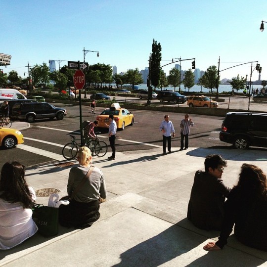
    In case you were wondering, the picture at the top of this post is from the steps at the Whitney Museum. They face the West Side Highway and the water. It’s a great public space, but I’m pretty sure that Renzo Piano wouldn’t have designed it that way (and with that orientation) had there been an elevated highway in front of it.