Daily insights for city builders, delivered every morning at 6 AM ET. I’m Brandon Donnelly — a Toronto-based real estate developer and founder of Globizen. I’ve been writing here since 2013.

Tag: mexico city

  • Learning from, but not copying, New York’s High Line

    image

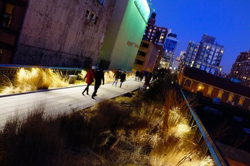
    In 1980, the last train ran on an elevated corridor on the west side of Manhattan known as the High Line. Originally built in the 1930s, the trucking industry had made these trains obsolete and service was halted.

    At this point, neighboring property owners began to lobby for the demolition of the High Line, as they no doubt saw it as an opportunity to increase the value of their land holdings. But thanks to local residents – most notably a man by the name of Peter Obletz – the 1.45 mile-long elevated rail corridor was saved from demolition.

    In 1999, Joshua David and Robert Hammond then decided to form a non-profit with the goal of both preserving and reusing this unused rail corridor. The group was called Friends of the High Line.

    By the early 2000s, Friends of the High Line had successfully made an economic case for transforming the rail line into a public open space and things started moving forward. Initially, it was thought that a public park of this sorts would attract about 400,000 people annually and generate upwards of $286 million in new tax revenues over the following 2 decades (Globe and Mail).

    With these expectations in mind, construction on the new High Line Park began in 2006. The first section opened in 2009 – a decade after Friends of the High Line was formed. And the third, and last section, opened just two weekends ago at the end of September.

    Today the High Line Park attracts 5 million visitors a year and is believed to be directly responsible for about $2.2 billion in new economic activity. The increased tax revenues over the next 2 decades are expected to reach about $980 million. Without a doubt, the High Line has been a huge success. It has become the 2nd most visited cultural attraction in New York (Globe and Mail).

    Which is why every city now wants their own High Line. Philadelphia wants one. Chicago wants one. Mexico City wants one. Seoul wants one. And the list goes on. Here in Toronto, we’ve recently proposed one called the King High Line, which will connect the Liberty Village and West Queen West neighborhoods across a rail corridor.

    While I do believe that this is an important connectivity problem to be solved, I worry about how explicit the references are to the actual High Line. Even the street furniture is the same in their promotional video.

    I worry not only because it means we’re clearly taking on the role of follower, as opposed to leader, but because an elevated park isn’t going to work in all urban contexts the same way that the High Line worked in Chelsea. This is similar to how Frank Gehry can’t magically turn your city into the next Bilbao. 

    So while I have shown my support by becoming a “Friend of the King High Line” (and I would encourage you to do so as well), it’s important to keep in mind that the problems we’re trying to solve here aren’t necessarily the same ones that New York had to deal with.

    The High Line – from the start – was designed to have an intimate relationship with its surrounding buildings. The tracks rain directly through them so that the trains could easily load and unload their cargo – that was the whole point. So when the High Line was redone, all of a sudden these buildings were able to reconnect themselves to the park in a way that they were already accustomed to doing.

    But in Toronto’s situation, and perhaps in your city, that’s not the case. We’re talking about stitching together two completely disconnected neighborhoods. It’s a noble goal and certainly one that I wholeheartedly believe we should pursue. But I don’t think we should assume that it’s a problem that has already been completely solved for us.

    Image: Flickr
  • The top 10 mega-cities by 2030

    One of the reasons I’m so fascinated by cities is that it’s becoming increasingly more important to get them right. From about 1831 to 1925, London was the largest city in the world. Its population went from somewhere around 1.5 to 2 million people to nearly 7.5 million. London surpassed Beijing as the largest city and was then surpassed by New York.

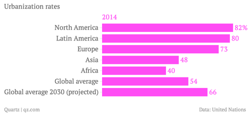
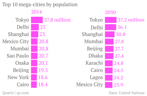
    Today our largest cities are significantly bigger. Tokyo has almost 40 million people and London doesn’t even make the top 10. But there’s also a broader shift taking place. According to a new report by the United Nations, most of the world’s largest cities will be in Africa and Asia by 2030. Here’s a chart from Quartz:

    image

    And the reason for this shift is because Asia and Africa are newly urbanizing, whereas the rest of the world has already urbanized. In North America, over 80% of people already live in cities.

    image

    But even though Asia and Africa are following a trend that has already taken place in the rest of the world, it doesn’t mean we should assume we know what we’re doing. Having spent time in cities like Dhaka, I can attest to the many challenges that these mega-cities are facing and will continue to face as people flood in from the rural areas looking for economic opportunities.

    So while it’s important that we talk about strategies for reviving cities like Detroit – which has a population somewhere around 700,000 – 800,000 people – we should also keep in mind that we have some significant challenges ahead of us in terms of creating a sustainable urban planning agenda for the world.

  • Urbanization in the developing world

    A few days ago I asked a reader of this blog if there was anything, in particular, that she’d like to see more of on here. She responded by saying that she’d love to learn more about how other cities—outside of Toronto—are managing urbanization, as well as how we shape cities and cities shape us.

    It’s an interesting and important question because, frankly, the challenges are greater outside of Toronto. One of the stats that often gets cited here in the media is how the Greater Toronto Area gets approximately 100,000 new immigrants every year. This doesn’t include domestic migration though, so I would assume that our total number is even greater.

    But if we stick with 100,000 for now, it means the GTA receives about 11.4 new immigrants every hour (100,000 people / 8,765 hours in a year). Lagos, Nigeria, on the other hand, receives between 50-60 new people every hour. In fact, it’s predicted to be 7th fastest growing city in the world between now and 2020. 

    If you take a look at the complete list of the world’s fastest growing cities (all estimates, of course), you’ll likely notice that the vast majority of the cities are in the developing world. And that’s really the challenge. The world is rapidly urbanizing and becoming the most urban it’s ever been, but the changes are the greatest outside of developed nations. This poses entirely unique challenges.

    Of the kinds of cities I’m talking about, I’m most familiar with Dhaka, Bangladesh. In my last year at Penn, I was part of a studio led by KieranTimberlake Architects that focused on water and housing issues in that city. It was a partnership with the University of Dhaka. We spent roughly 2 weeks there and it was an eye opening experience.

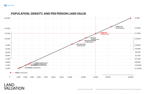
    Here’s a telling slide from our final presentation:

    image

    What we were trying to do with this chart was compare population and per person land value for our development site according to various city types. In other words, we were essentially asking: If we were to build out our proposed site in the same way, as say, Dallas, Los Angeles, Hong Kong, or what is typical for Dhaka, how many people could we fit and what would be the resulting per person land value?

    I don’t remember where we got the land value figures from, but we were trying to be cognizant of the fact that every city requires a unique solution. Using the same per person land values in Dhaka as in Dallas would be unimaginable because Dhaka has over 40,000 people per square kilometre (top right on the diagonal line above) and Dallas has under 1,400 per square kilometre (bottom left on the diagonal line above).

    The challenges of urbanization in the developing world are profound, particularly in places like Dhaka where most of the city is subject to severe annual floods. By some estimates, 18% of the city’s land area gets flooded every year—talk about adding another layer of city building complexity.

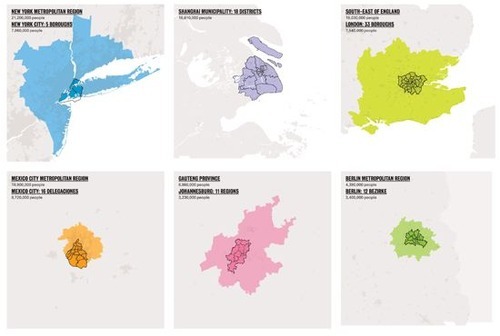
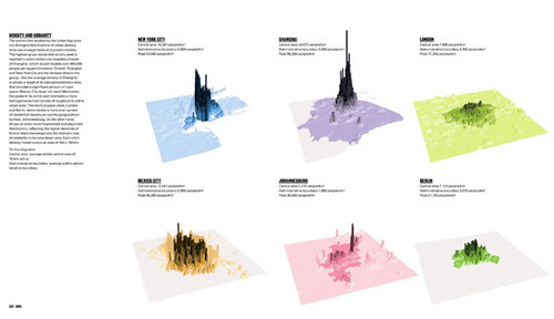
    We didn’t solve all of the problems in that studio and we’re not going to do it here, but I do think it’s important to fully understand the problem. One of my favorite books on cities is called “The Endless City.” It examines New York, Shanghai, London, Mexico City, Johannesburg and Berlin, and has a ton of great data and diagrams.

    Here are a two that outline densities and land use patterns for the above 6 cities (same order starting on the top left):

    image

    image

    If you’re interested in cities, it’s definitely worth having it on your coffee table. And fitting to @PhatNancy’s tweet, ”The Endless City doesn’t just show how cities are changing but also how they are changing us.”

  • House Hunting in …Mexico City

    A large percentage of foreign homeowners in Mexico City are American; the city wasn’t badly shaken by the global economic downturn.

    House Hunting in …Mexico City