Daily insights for city builders, delivered every morning at 6 AM ET. I’m Brandon Donnelly — a Toronto-based real estate developer and founder of Globizen. I’ve been writing here since 2013.

Tag: light rail transit

  • The case for planning transit around minimum population densities

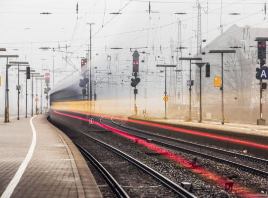
    Photograph Blitz by Tristan O'Tierney on 500px

    Blitz by Tristan O’Tierney on 500px

    Back in 2011, the The Pembina Institute published a report called, Building transit where we need it. And in it they quite clearly outlined the population densities that are needed to make various types of transit investment cost effective.

    For subway they specify a minimum population density of 115 people per hectare and for light rail (LRT) they specify a minimum population density of 70 people per hectare. 

    And the reason for this is because there’s a strong correlation between population density (i.e. land use) and transit ridership. The two go hand in hand and should not be decoupled. If population densities are too low (as they are, for example, along the Sheppard subway line here in Toronto), people don’t take transit. They drive.

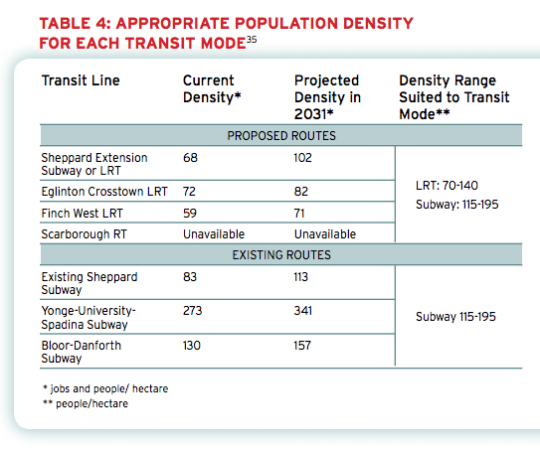
    Here’s a chart from the report showing the current and projected population densities for Toronto’s existing and proposed routes (keep in mind this is from 2011).
    image

    So what does this chart tell us?

    • Subways don’t make a lot of sense in many parts of the city. LRT will do just fine.
    • The Sheppard subway line is an under-utilized asset. Even by 2031 we’ll barely be reaching the requisite population densities.
    • The Bloor-Danforth corridor could use more intensification.
    • The Yonge-University-Spadina line is going to need to relief.

    Unfortunately, transit decisions are often made based on politics instead of data. And that results in subways in places that don’t make a lot of sense. That’s unfortunate because it means less riders, less revenue, and more subsidies.

    The other challenge with running subways through low density neighborhoods is that it then creates tension when the city and developers go to intensify those neighborhoods through transit-oriented development. (See #DensityCreep.)

    But if we’re going to be fiscally irresponsible about where we deploy our transit capital, the least we could do is upzone the surrounding areas and impose minimum population densities. 

    In fact, here’s what I think we should do: Land use should be bundled with the transit decision. 

    Instead of asking where the subway station should go, we should be asking where the subway station should go and all the density needed to bring the area up to a certain minimum population density. And if that second criteria for whatever reason can’t be met, then we don’t build the line. 

    I wonder if we framed the question in this way if it would change where subway lines get approved. What do you think?
  • Metrolinx takes first step towards rail + property in Toronto

    image

    I’ve written quite a bit about the advantages of a “rail + property” model when it comes to building public transit. It’s a model that works quite successfully in other parts of the world, such as in Hong Kong.

    However, in North America the notion of land value recapture or of transit authorities acting as real estate developers is still very much in its infancy. We’re myopically focused on rail. 

    Which is why I said about 3 months ago that if the stations along the new Eglinton Crosstown LRT line in midtown Toronto became single storey and single purpose buildings, that we will have missed an enormous city building opportunity.

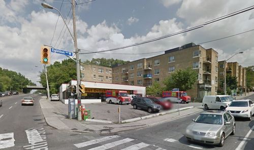
    Since that post I had a number of conversations with the folks over at Metrolinx and I was delighted to learn that there were in fact plans to build additional density on top of the stations. And as of today they’ve gone completely public with that intention.

    Metrolinx, with the help of Avison Young, has just issued a request for proposal (RFP) for 4 sites along Eglinton Avenue in the city. Two of them are at Keele Street, one of them is at Weston Road, and the last one is at Bathurst Street. The 4 sites could generate between $14M – $22M.

    The objective is to find suitable developer partners to help them build on top of their planned LRT stations. And it’s a step in exactly the right direction for Metrolinx and this city.

    Image Source: Google Streetview

  • Riding the new streetcar

    image

    This afternoon I rode Toronto’s new streetcar for the first time on my way home from Chinatown. I had been meaning to do it for weeks now, but this was my first opportunity.

    The experience was infinitely better than what you get today on our current streetcars. I felt like I was in a new city. The proof-of-payment system makes onboarding much faster and the 4 loading doors means you just get on the train where there’s the most room – instead of getting on at the front and fighting your way to the back.

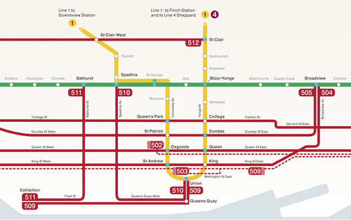
    The other thing I liked is that they now have a map of our streetcar network within the train (see above image). Toronto never used to do this. For whatever reason, we didn’t like mixing subway lines with streetcar lines on the same map. 

    But why be so pedantic?

    For one thing, our subway map looks pathetic without these additional streetcar lines on it. So for the sake of Torontonian morale, please fill it up with what you can.

    But the other reason why I think it’s important to include them is that we shouldn’t be thinking about our cities just in terms of specific technologies (subway, streetcar, and so on). Our cities are now multi-modal. Which means we navigate them using many different means, from subways and streetcars to bikes and Uber cars. What people care about is getting from A to B in the most efficient and enjoyable way possible.

    This may seem like a subtle distinction, but it’s an important one. And maybe, just maybe, these new maps will serve as an important reminder to us that there’s a lot of fixed rail in this city and that it could be far better optimized if we just tried a little harder.

  • Multi-modal cities are the new reality

    CityLab published an article last week on multi-modal cities that caught my attention (because it used a picture of Toronto with about 3 or 4 streetcars stacked up along Queen Street). The premise of the article is that all of this car vs. transit debate is actually missing the bigger picture: our cities are multi-modal and we need to be planning for that.

    That’s not to say that the shift away from cars isn’t a good thing. It is. But it’s not as simple as saying that, instead of driving, people should now only take transit. In today’s cities people walk, bike, take streetcars, take buses, take subways, take taxis, take private shuttles, use Uber, and, yes, they still drive.

    From my own experience, this is absolutely how I get around Toronto today. I walk to the gym. I ride my bike whenever I’m going somewhere downtown. I take the subway to my office in midtown because it’s far and I would be too sweaty if I biked there. I use Uber and Hailo when I’m going out at night. And I drive when I need to go to the suburbs or leave the city.

    But the key takeaway here is that we now have a much tougher challenge on our hands. When we were only optimizing for cars – however detrimental to our cities that was – we only had one mode to plan for. Now we have several. Some of which are public and some of which are private.

    However we also have access to technologies that we didn’t have before. We are networked in ways that weren’t possible before and we’re at the dawn of many profound mobility changes, such as driverless cars. (Have you read about Tesla’s new Autopilot feature yet?)

    So as I’ve said before, I really believe that we need to look at this, not as a war on the car, but as a war on inefficiency. The problem we are trying to solve relates to mobility: What’s the best way to move lots of people around dense urban regions? Stop focusing so much on the technologies and focus more on the people.

    Image: Flickr

  • Understanding the radius of demand for transit

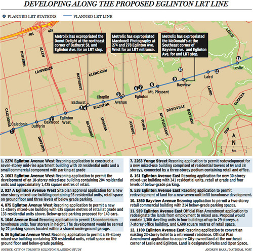
    Last week The National Post published an article talking about Toronto’s Crosstown LRT and how it’s spurring a wave of development all along Eglinton Avenue. Below is a map, taken from that article, showcasing some of the developments that are currently in the pipeline and awaiting the Crosstown’s opening date of 2020.

    image

    Not surprisingly, developers like transit investment. But more specifically, they like fixed track transit investment. Rarely do new bus routes elicit the same sort of response that you’re seeing above. And that’s because fixed track investment has permanence. If you’re going to go long on an area, you want certainty.

    As the Crosstown tunnel boring machines move across midtown Toronto, I thought it would be interesting to look at a transit concept that I first learned about through Jarrett Walker’s Human Transit blog. It’s called: the radius of demand

    One of things that transportation planners look at when designing and building a new line is the spacing of stops. Typically, as you move from buses all the way up to subways, the spacing between stops and stations increases. Spacing is always a bit of a trade off though, because more stops means easier access for riders, but it also means slower overall service. Somewhat famously, Paris designed its metro system so that you’re rarely more than 500 meters away from a station. 

    Once you have your station locations, it’s quite common to then draw a radius around each stop to simulate the catchment area. In other words: How much of the city can I service with this station and how far will people be willing to walk in order to get there? However, this distance, which is the radius of the circle, usually depends on the type of transit. Oftentimes people are willing to walk further in order to get to faster transit service.

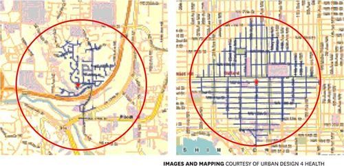
    But what’s most interesting about this radius of demand is that it’s entirely dependent on the fabric of the city. Take for example, the following two maps from Seattle, which I have taken from Walker’s blog. On the left is a suburban setting and on the right is a downtown setting. In both cases, the red circle represents a 1 km radius.

    image

    Now, if humans could fly over barriers, such as highways, and every Seattle resident was willing to fly exactly 1 km to a transit station, these two radiuses of demand would be perfectly accurate. But since that’s not the case, we instead need to look at what actually represents a 1 km walk – those are the blue lines in each image.

    Because once you do that, you realize that the cul-de-sacs and highways on the left make it impossible for most of that radius of demand to actually walk to the station in under 1 km. So the catchment area actually becomes much smaller. On the other hand, if you look at the image on the right, you’ll see that the tried and true city grid is actually remarkably efficient for walking. Almost all of the circle is serviced.

    So as the Eglinton Crosstown LRT makes its way through the center of Toronto, I think it’s important to keep in mind that it’ll be cutting through quite a few different kinds of street grids. Some of them will be highly conducive to transit usage and others not as much. And in many ways, this is one of the greatest challenges of transit investment. The track itself is only one part of the puzzle.

    That’s why the City of Toronto is also undertaking a planning exercise called Eglinton Connects. Its intent is to leverage the opportunities, as well as address the challenges, that will result from Metrolinx’s Crosstown LRT. If you’re interested in the future of Eglinton Avenue, you should consider getting involved. Oftentimes it’s only the critics that speak up. But that’s not the best way to build anything.

  • Transit vehicle capacities compared

    I was cruising the twitter sphere yesterday when I came across the following chart, outlining the various transit vehicle capacities here in Toronto. It was created by Cameron MacLeod of #CodeRedTO, which is a grassroots group advocating for “a rational, affordable, and achievable rapid transit strategy for Toronto.”

    image

    On the left you have the vehicle type and then you have the capacity in terms of number of seats and standing room. The planned capacity is essentially the sum of those two numbers and the “unsafe crush load” is the number of people you could fit if you really put your back into it.

    Articulated buses refer to the longer (1.5x) bendy ones and, similarly, ALRV streetcars are the longer, articulated version of our regular streetcars. The low-floor streetcar is similar to what Toronto will be getting. And SRT is the Scarborough Rapid Transit system.

    The chart also compares between vehicle types: How many cars would you need to move the same number of people? How many buses? And so on. As one example, you would need 15.9 buses or 982 cars to move the same number of people as the Yonge subway line!

    What’s missing from the above chart though is light rail transit (LRT), which is comparable to the linking of up to 3 low-floor streetcars. In the case of the under construction Eglinton Crosstown LRT line, the planned capacity is 750 people!

    This is an hugely important takeaway because many people, including our own Mayor, do not properly distinguish between streetcar and light rail. The two are not one and the same. LRT has the potential to move a lot more people.

    In fact, at 750 people, the Eglinton Crosstown could move more people than the Sheppard subway line, which is only operating on 4 cars (as compared to 6 on our other subway lines).

    So while it’s all fine and dandy to bang our fists on the table and advocate for subways, they don’t make economic sense in all parts of our city. With the Sheppard line, we’ve been leaving capacity on the table and wasting taxpayer money.

    Of course this chart is also useful for those outside of Toronto. What I like about it is that it clearly shows the tool chest available to cities when it comes to building transit. Every city and neighborhood is different. And I think it’s important to have intelligent conversations about what makes sense in each.

    Thank you to Cameron and #CodeRedTO for allowing me to post their work.

  • Turning St Clair and Spadina into LRT

    I’ve talked before about how Toronto doesn’t currently have any true light rail transit lines. LRT does not equal what we have on St Clair Avenue. The stops are spaced far too close together. It’s just a streetcar on its on right of way.

    This is better than a streetcar that doesn’t have its own right of way, but it could be better. So here’s an idea for better optimizing some of the transit infrastructure we already have: let’s convert the St Clair and Spadina streetcar lines into true LRT.

    Here are 3 things we could do.

    1.

    First, we need to get rid of some stops. Let’s take the stop spacing being proposed for Eglinton Avenue and apply it to St Clair Avenue and Spadina Avenue. By stopping less, it means performance goes up. Think about how much time is wasted every time the streetcar has to stop for people to get on and off. This is why New York has express trains.

    Alternatively—and instead of actually getting rid of some stops—we could also just operate two types of stops: rush hour stops and off-peak stops. In the case of off-peak stops, the streetcar would simply skip them during rush hour. The cost of implementing this would be signage and consumer education.

    2.

    Second, we finally roll out a better payment system. While tokens do give me a kind of 1960s nostalgia, I hate change and I hate fumbling with microscopic tokens in my pocket. Why isn’t there an app for this?

    But more importantly, if we had a better payment system we could transfer the point of payment from the actual streetcars to the stops themselves. This would mean that you’d need to pay in order to gain access to the stop itself. The benefit of this though is that it streamlines onboarding. Customers can now just walk onto the streetcar, like they do on the subway.

    And if you’re thinking about those times where you give up waiting for a streetcar and just hail a cab, well we could simply make the fare refundable if you leave at the same stop. This type of system would also open up the possibility of distance based fares (see London, Tokyo, etc.)

    3.

    Third, put the LRT lines on the subway map and operate them with the same rigour. Right now the customer experience gap between subways and streetcars is huge. Subways run on time and streetcars are completely hit or miss. There’s an excuse for streetcars that run mixed in with traffic, but I don’t see why we can’t make light rail (using its own right of way) just as predictable as subways. I used to take the LUAS in Dublin everyday and it was a fantastic experience.

    We really need to start taking transit more seriously in Toronto. I don’t know about you, but I’d much rather be known around the world for having the best transit system than for having a debaucherous mayor.