Daily insights for city builders, delivered every morning at 6 AM ET. I’m Brandon Donnelly — a Toronto-based real estate developer and founder of Globizen. I’ve been writing here since 2013.

Tag: liberty village

  • Density vs. infrastructure in Liberty Village

    A beautiful new 43-storey rental building was just approved in Toronto’s Liberty Village neighborhood. More info about the project can be found, here. Not surprisingly, some people in the community were against it. Here is a recent article that blogTO published talking about people who live in high-rises not wanting a new high-rise next to them.

    One argument that is being made is that the neighborhood is already full. It has reached its density limit. We also hear this about the City of Toronto as a whole. But we know this isn’t true. Architect Naama Blonder recently did a study that found we could fit another 12 million people within our boundaries with more efficient land use policies.

    This particular site in Liberty Village is also about 400 meters from a future subway stop on the Ontario Line. So it is exactly where we should be putting more density. The problem today is that the area is suffering from a massive infrastructure deficit. The road network is inadequate and the King streetcar hasn’t been prioritized.

    It’s no wonder the area feels full. But the reality is that there are lots of examples of highly livable neighborhoods from around the world with much higher population densities. The difference is that they have the right infrastructure, the right public realms, and the right modal splits.

    Liberty Village will get there as well and it’s already underway. For a preview of the future, check out the City of Toronto’s Public Realm Strategy for the area. It was published in April 2024 and it includes things like new streets, new mid-block connections, and new parks. It is what the area needs and it’s exciting to see it happening.

  • Toronto’s King Street to be transformed into a transit + pedestrian corridor

    Take The Car by Jason Cook on 500px.com

    https://500px.com/embed.js

    I try not to focus on local Toronto issues this much, but this morning an important initiative was announced and it’s blowing up my Twitter feed.

    By spring 2017, the city hopes to have a pilot project in place that will transform King Street – running from Liberty Village in the west to the Distillery District in the east – into a priority-transit and pedestrian corridor.

    This isn’t to say the street will be closed to cars. I would imagine that at least 1 lane would remain for cars going each way. Instead it will be redesigned to prioritize transit, pedestrians, and cyclists.

    So why is this exciting?

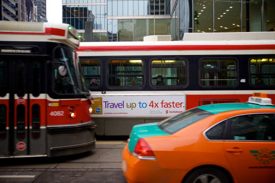
    The King streetcar is currently broken. If you’ve ever taken it across downtown during rush hour, you know exactly what I mean. It’s infuriating. You might as well be crawling on your hands and knees. One of the goals of this initiative will be to get it working again. Good.

    The shoulders of downtown – along King West and King East – are seeing some of the greatest intensification in the region. So much that it’s common for people in this city to complain that Toronto misplanned it all by allowing this development before the transit was there. Well, this is a quick and inexpensive way to get the transit there. Remember that when the inevitable “war on car” rhetoric ratchets up over the next year.

    The project will be deployed, first, as a pilot project. That will allow the project team to test and iterate. It has also become the way you get things approved in cities. You first make them temporary. 

    But I am certain that we will quickly discover how necessary these changes were.

  • A year in review — 2015 on Architect This City

    Thanks to this blog, it’s pretty easy for me to go back and look at what I was doing and thinking throughout the year. That’s one of the benefits of writing a daily blog/journal. And as is usually the case, 2015 was a year of ups and downs.

    For my annual ski and snowboard trip with the guys, we went to Banff (Alberta) and Revelstoke (BC). But we got stuck with unseasonably warm weather in the west (the opposite of what’s happening this winter) and I got injured on day 3. That put me in the emergency room and knocked me out of snowboarding for the rest of the season – as well as from the gym for a number of months.

    Shortly after that I also got struck with some family health issues. That was pretty scary for a good solid month, but in the end, everything seems to have worked out. What a relief.

    Towards the end of March, I did a brand partnership between Architect This City and Porter Escapes, which brought me to Quebec City for a weekend. That was a lot of fun and gave me the opportunity to be a real flâneur in one of the most interesting cities in Canada.

    In April, I left my real estate development job at TAS and shortly after I joined CAPREIT (TSE: CAR.UN) to help build out their (real estate) development platform. Previously their/our focus had just been on acquiring existing rental assets. But now it is time to build.

    Later this month I also participated in the Toronto filming of a documentary called Waterfront Cities of the World. That was a lot of fun. But come to think of it, I don’t think I ever watched the final video.

    In May, I started lobbying hard for the removal/replacement of the eastern portion of the Gardiner Expressway East here in Toronto. If you’ve been reading this blog since the summer, I am sure you remember this period. With the help of a colleague of mine, I even started a petition that ended up getting presented at City Council.

    But in June, Toronto City Council voted to demolish and then rebuild the elevated expressway along our waterfront. I am still surprised by that. What a shame.

    In July, we (CAPREIT) announced our first joint venture development project. A mixed-use project – 506 rental apartments on top of about 160,000 square feet of retail – in Toronto’s Liberty Village. 

    In August, I went back to Philly to relive my Penn days. I do that every couple of years just to make sure that Bob and Barbara’s is still offering up “The Special.” The Special is a can of PBR and a shot of Jim Bean for $3. It’s famous in Philly, but it always sounds like a far better idea the night before, as opposed to the morning after.

    In this same month I also hit the 2 year mark here on Architect This City. That’s 2 years of getting up every single day and staring at a blank blog post screen and thinking of something insightful to say. 

    The following month on September 11 (I’ll never forget this date), I got laser eye surgery. More specifically, I got custom wavefront LASIK. And today it’s pretty hard to imagine that I used to have to reach for my coke bottle glasses as soon as I woke up every morning.

    Later in September, I also gave a talk at my alma mater, the Rotman School of Management, to a delegation of about 70 urbanists from Portland. It was an honor to be invited alongside rockstars such as Richard Florida and Jennifer Keesmaat.

    In October, I featured a guest post from the former mayor of Toronto, John Sewell. I don’t often do guest posts on my blog, but John had just published a new book and I thought it would be a good way to change things up here. John and I aren’t necessarily on the same page with many urban issues, but we did agree on the Gardiner East.

    For the remainder of October, it was basically just the Jays.

    In November, I spoke at a Product Hunt event focused on real estate + tech. It was incredibly encouraging to see so many entrepreneurs here in Toronto focused on the intersection of real estate and tech. There are lots of opportunities in this space and I am sure that there are many success stories in the making right now. Toronto is the perfect place for real estate + tech innovation.

    And finally, in December, I crossed something off my bucket list and attended Art Basel Miami Beach. I have wanted to go for well over a decade; pretty much since I started studying art history in undergrad. I don’t know what took me so long.

    Oh, I also announced that I was writing a book on becoming a real estate developer

    What a year. I can’t wait for 2016. 

    What do you have on your to-do list for next year?

  • CAPREIT announces first joint venture development

    Yesterday CAPREIT announced that we have entered into our first joint venture development agreement for a mixed-use project at 1100 King Street West in Toronto’s Liberty Village neighborhood. 

    The agreement is to acquire a 1/3 undivided interest in the residential component of the project for $60.3M. The residential component will consist of 3 towers and 506 apartment suites (sitting on top of a roughly 160,000 square foot commercial/retail podium that will not be owned by CAPREIT).

    Here’s what Thomas Schwartz, President and CEO of CAPREIT had to say:

    “We expect our interest in the property, combined with the property management fees we will receive, will be accretive to our cash flow and set the stage for similar partnerships, along with our own new rental developments in the future.”

    As a member of the development team at CAPREIT, it feels great to get this one out there.

    Click here for the full public press release.

  • Learning from, but not copying, New York’s High Line

    image

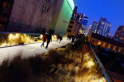
    In 1980, the last train ran on an elevated corridor on the west side of Manhattan known as the High Line. Originally built in the 1930s, the trucking industry had made these trains obsolete and service was halted.

    At this point, neighboring property owners began to lobby for the demolition of the High Line, as they no doubt saw it as an opportunity to increase the value of their land holdings. But thanks to local residents – most notably a man by the name of Peter Obletz – the 1.45 mile-long elevated rail corridor was saved from demolition.

    In 1999, Joshua David and Robert Hammond then decided to form a non-profit with the goal of both preserving and reusing this unused rail corridor. The group was called Friends of the High Line.

    By the early 2000s, Friends of the High Line had successfully made an economic case for transforming the rail line into a public open space and things started moving forward. Initially, it was thought that a public park of this sorts would attract about 400,000 people annually and generate upwards of $286 million in new tax revenues over the following 2 decades (Globe and Mail).

    With these expectations in mind, construction on the new High Line Park began in 2006. The first section opened in 2009 – a decade after Friends of the High Line was formed. And the third, and last section, opened just two weekends ago at the end of September.

    Today the High Line Park attracts 5 million visitors a year and is believed to be directly responsible for about $2.2 billion in new economic activity. The increased tax revenues over the next 2 decades are expected to reach about $980 million. Without a doubt, the High Line has been a huge success. It has become the 2nd most visited cultural attraction in New York (Globe and Mail).

    Which is why every city now wants their own High Line. Philadelphia wants one. Chicago wants one. Mexico City wants one. Seoul wants one. And the list goes on. Here in Toronto, we’ve recently proposed one called the King High Line, which will connect the Liberty Village and West Queen West neighborhoods across a rail corridor.

    While I do believe that this is an important connectivity problem to be solved, I worry about how explicit the references are to the actual High Line. Even the street furniture is the same in their promotional video.

    I worry not only because it means we’re clearly taking on the role of follower, as opposed to leader, but because an elevated park isn’t going to work in all urban contexts the same way that the High Line worked in Chelsea. This is similar to how Frank Gehry can’t magically turn your city into the next Bilbao

    So while I have shown my support by becoming a “Friend of the King High Line” (and I would encourage you to do so as well), it’s important to keep in mind that the problems we’re trying to solve here aren’t necessarily the same ones that New York had to deal with.

    The High Line – from the start – was designed to have an intimate relationship with its surrounding buildings. The tracks rain directly through them so that the trains could easily load and unload their cargo – that was the whole point. So when the High Line was redone, all of a sudden these buildings were able to reconnect themselves to the park in a way that they were already accustomed to doing.

    But in Toronto’s situation, and perhaps in your city, that’s not the case. We’re talking about stitching together two completely disconnected neighborhoods. It’s a noble goal and certainly one that I wholeheartedly believe we should pursue. But I don’t think we should assume that it’s a problem that has already been completely solved for us.

    Image: Flickr

  • The demand for character office space

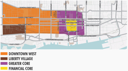
    Last Friday the Toronto Star published an article talking about the growing demand for character office buildings in submarkets outside of Toronto’s core. Specifically, it was talking about the Downtown West and Liberty Village submarkets (citing a report from CBRE).

    I’m sure this isn’t news to most of you. Cool loft spaces have been popular for years. But it’s interesting to look at how rents and vacancy rates have changed for these submarkets and product types over time.

    Since 2002, average (net) asking rents for brick-and-beam buildings in the west end have gone from $16.12 to $22.23 per square foot. Almost a 38% increase. By comparison, office space in the core has gone from $28.40 to $32.38 per square foot. A 14% increase.

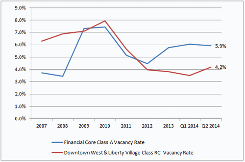
    And if you look at vacancy rates since 2007, you’ll see that the character office market has really tightened up over the past 4 years or so. There’s growing demand for a limited amount of supply.

    With the growth that the downtown core is seeing and with the rise of Toronto as a creative startup hub, I’m sure we’ll continue to see strong demand for this type of space. But there’s only so much of it to go around. So I think we’ll also end up seeing greater interest in the east side of downtown and also more interesting new builds.

    Images/Charts: CBRE

  • Could driverless cars be a big deal for cities?

    image

    I’m a big believer in public transportation. I generally believe that the only way to build a big, efficient, and sustainable city is on the backbone of a good transit system. But at the same time, I’m open to fresh ideas. And I’m concerned with the inability of most cities to actually build transit in a way that meaningfully responds to demand.

    So what are the alternatives?

    The first thought that comes to mind is the delivery system itself. Some cities, such as Hong Kong, have successfully combined transit delivery with real estate development as a way to improve the economics behind building transit. And I think that makes a lot of sense.

    But my other thought is that maybe the solution to urban mobility is something completely new. Maybe Google is on to something with their driverless cars. Is that the future? Many would disagree.

    We’ve established that cars don’t work all that well for getting people around in big congested cities. So what difference would it make whether or not the cars have a driver or not? Well, I was thinking about this last night and there are some meaningful differences.

    A network of driverless cars would give us perfect information about all to the cars on the road. Similar to to how Google’s Waze navigation app feeds off user input (both active and passive), we’d know the exact number of cars on the road and the precise point in which additional cars would cause a drop in efficiency (i.e. a reduction in vehicle speeds).

    At the same time, it could enable a powerful sharing economy. In a recent study done by MIT’s Senseable City Lab, it was found that roughly 80% of New York cab rides could be shared. That is, 80% of the time there’s somebody else who’s also traveling from roughly the same point A to the same point B.

    So here’s what I’m thinking.

    You use Google’s driverless car technology and the perfect information you get from the networked vehicles to create a fluid and ever-evolving transit network. What I’m imagining is that the driverless vehicles don’t operate based on a model of individual mobility; they instead operate on a principle of batched mobility.

    Let’s say for example that there are critical mass of people who want to leave Liberty Village between 8:00am – 8:30am to travel to the Financial District. What they would do is enter this itinerary and then a “station” would get formed somewhere nearby. Users would get notified of the station’s location, which would be determined based on proximity to the highest concentration of “riders.”

    The driverless cars would then get notified and would begin assembling the appropriate number of vehicles at the selected station location. As is the case with conventional forms of public transportation, most people would need to walk to the station. But never that far.

    In essence, it would function as a cross between private and public transportation. You would get the economies of scale generated by public transit, with some of the individual conveniences of private transportation.

    How does that sound?

  • Toronto mayoral candidate announces regional express line

    image

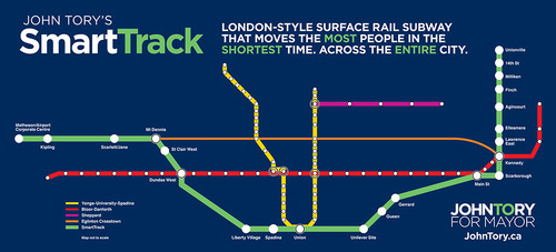
    Yesterday Toronto mayoral candidate, John Tory, proposed a transit line called SmartTrack. It’s part of his One Toronto transit plan. If you’re interested in watching the full 30 minute announcement, click here.

    As somebody who came out of the gate as a strong proponent of the “Yonge Relief Subway Line” (and as somebody I immediately supported for that reason), this proposal first hit me yesterday as a disappointment. Not because I don’t think we need a regional express rail network in the region (we do), but because I feel that he is backing away from that initial commitment and depriving the core of the transit infrastructure it needs.

    As soon as I found out about the plan, I immediately emailed one of my friends at Metrolinx. I told him I thought it was an “epic fail”. He pushed back and asked me to consider the merits of Tory’s plan. After having slept on it (and calmed down), I’m now prepared to talk about both the benefits of SmartTrack and why I was disappointed. 

    SmartTrack is basically a regional rail plan, intended to move people from the outer and inner suburbs to and from downtown using an integrated fare system. That is, riders will not have to pay a separate fare to transfer from subway to SmartTrack. 90% of the track needed for the plan is already existing, which means it will be cheaper and quicker to build compared to the full relief subway line. It will also bring employment centers such as Airport Corporate Centre in Mississauga into the transit network. For these reasons, the SmartTrack plan would certainly be beneficial for the region. 

    But, there’s a densities mismatch.

    If you look at the number of stops proposed in Scarborough and Markham, and compare it to the number of new stations proposed for downtown (1 – Spadina station) and the downtown shoulder neighborhoods (2 – Liberty Village and the Unilever site), the plan starts to look lopsided. SmartTrack would help residents of downtown get out to the suburbs, but it would do little to help them move in and around the core.

    If you look at the way Toronto is intensifying on a map, it looks like an upside down letter T. Density now hugs the waterfront and then follows our subway lines up north. I believe that the SmartTrack plan would help to relieve the pressures on those subway lines, but I don’t think it adequately addresses the bar of the T that now runs parallel to the lake.

    So while I do think that the Toronto region would be well served by regional express rail, I don’t think we can forget about the central part of the city. This shift in focus may have something to do with where Tory believes his voter base now sits, but let’s not forget that there’s a strong correlation between population density and transit ridership levels. 

    Now, let’s hear from you. What do you think of Tory’s One Toronto plan and SmartTrack proposal?

  • Every street can’t be everything to everyone

    Yesterday I spoke about why Toronto shouldn’t be so quick to dismiss streetcars and light rail. Today, I’d like to talk about some of the hard decisions we need to face if we really want to get our city moving.

    Toronto is a city of neighborhoods and small main streets–at least in the areas where our streetcars live. Streets such as King and Queen are only 4 lanes. And the problem we’re facing is that we’re trying to accommodate every single use case on them: cars, on-street parking, cyclists and streetcars. But in doing so, we’ve made the experience terrible for everybody. Streetcars move at a snail’s pace, drivers are frustrated by the lumbering streetcars, cyclists fear for their life driving by parked cars (doors can swing open at any time), and so on.

    And with the rise of downtown shoulder neighborhoods such as Liberty Village, King West, the Distillery District and the soon to be complete West Don Lands, the strain on our east-west corridors is only going to get worse–much worse, in fact. Already the King streetcar is the busiest streetcar route in the city, moving almost 60,000 people per day. That’s more than the (under utilized) Sheppard subway line.

    What I hope is clear to the ATC community though, is that the answer isn’t uniformly the car. We can’t have every single resident from Parkdale to Leslieville hopping into their car and driving downtown to their office at Yonge & King. It ain’t going to work. And so we’re going to need to make some difficult decisions about how we’re going to get our city moving on the backbone of transit.

    Sure the downtown relief subway line (screw the politics I’m attaching it to downtown) would be the ideal solution to connecting our emerging shoulder neighborhoods, but that’s not going to happen overnight. And so how do we improve the efficiency of what we already have? First, we need to accept the fact that every street isn’t going to be everything to everyone at all times. We need to choose who we want to optimize for.

    So here’s an idea that’s been floated many times before but never acted upon: let’s get rid of cars on King St and Queen St in the core during rush hour.

    This would give our streetcars the room to efficiently move people across downtown, minimizing the dreaded “bunching up” that occurs as a result of traffic congestion. It would make transit a reliable choice and there are ways to pilot it. But let’s be clear: this is not about being anti-car. It’s about optimizing uses and getting people moving. Cars would continue to get priority on Richmond St and Adelaide St, and transit riders (as well cyclists) would get priority on King and Queen.

    Of course, the Rob Ford viewpoint would say that we should be optimizing all streets for cars and getting the streetcars completely out of the way. But if that’s the approach we want to take, then we’re building the wrong kind of city. We shouldn’t be focused on intensifying and creating new inner city neighborhoods, because that only tips the scale in favor of transit. Instead, we should be focused on decentralization.

    But that’s what not we’re doing. We’re intensifying our city to the point that we’re now faced with a number of difficult–yet enviable–decisions about how we’re going to live and how we’re going to move around in the future. We’re a city in transition.

    Our mission here should be to figure out how to move people around the city as efficiently possible. Let’s put politics aside and recognize that time is one of our most precious resources. And when we put people in lumbering streetcars and debilitating traffic jams, we’re completely squandering that resource. It hurts productivity and it hurts our overall prosperity as a global city.

    There’s a place for subways, streetcars, buses, bikes and cars in our city. So let’s just get on with making them all work.