Daily insights for city builders, delivered every morning at 6 AM ET. I’m Brandon Donnelly — a Toronto-based real estate developer and founder of Globizen. I’ve been writing here since 2013.
Last night when I was thumbing through Twitter before bed, I came across this blog post describing Vancouver’s land use types. The blog itself is called Mountain Doodles, but it’s not exactly clear who the author is.
In any event, what she/he did was analyze Vancouver’s land use dataset to come up with a series of charts that break down the percentage of each type: residential single detached, residential low-rise apartment, commercial, green space, and so on.
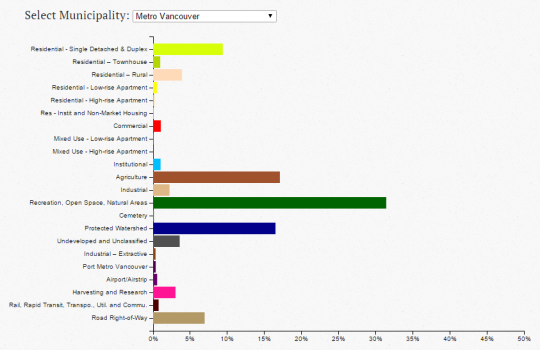
Here’s what the chart looks like for Metro Vancouver:
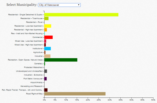
And here’s what it looks like for just the City of Vancouver, proper:
When you look at the metro area, green / open space dominates. Although, the author states that, given the dataset, there could be a small overstatement of green space. There’s also the question of where the overall boundary was drawn.
When you look at only the City of Vancouver, it’s land for residential housing (detached and duplex) and roads that dominate, with green / open space coming in a somewhat distant third.
Of course, this does not speak to the intensity in which any of the above land might be used, such as the apartment lands (i.e., the third dimension). But from a two-dimensional perspective, you certainly get a sense of what we – for better or for worse – have chosen to privilege.
Today I spent the day at the 11th Annual Land & Development Conference here in Toronto. I found it particularly good this year, but it’s now late, I’m tired, and I want to go watch game 6 of the NBA finals. So I think this is going to be a fairly short post.
Here’s a summary of some of my key takeaways from the day (a lot of it is Toronto-centric):
Increasingly, the commercial and residential sides of the real estate development business are converging. And it’s being largely driven by the focus on urban intensification and mixed-use.
This is leading to an “institutionalization” of the residential side, which has historically been the domain of smaller private/local companies and rich families.
Merger is creating complexity around asset valuations: Is it about the income (cap rates) and/or the future development potential?
Low rise house prices in Toronto continue to skyrocket. Supply is highly constrained. This has been the story for a number of years now.
High rise condo prices in Toronto continue to be more or less flat (modest increase). The industry is going to need to figure out how to work with and compliment the current surge in rental apartment development. There is an element of competition between the two asset classes.
According the RealNet’s new home price index, the spread between low-rise and high-rise housing in the Greater Toronto Area widened to $326,659 as of this past April (2015).
Rental Apartment Case Studies: Motion on Bay by Concert Properties (Bay and Dundas) was underwrote at $2.60-2.80 psf rents back in 2009. Rents are now in the $3 range. The Heathview by Morguard (Bathurst & St Clair) had $2.80-2.90 psf rents in its pro forma. It achieved and beat these numbers.
There’s a flood of Asian money coming into (1) Vancouver and then into (2) Toronto looking for development projects. There appears to be a lot of impatient and/or dumb capital out there. Challenge remains finding good development sites.
I will end by saying that I found there to be greater transparency at today’s conference. There was a lot of talk about deal specifics and I don’t remember seeing this much detail at past conferences.
Maybe I just wasn’t paying attention closely enough before or maybe the industry is slowly becoming more transparent. I hope it’s the latter.
If you were there today and I missed something groundbreaking, please share it in the comments below!
Back in 2011, the The Pembina Institute published a report called, Building transit where we need it. And in it they quite clearly outlined the population densities that are needed to make various types of transit investment cost effective.
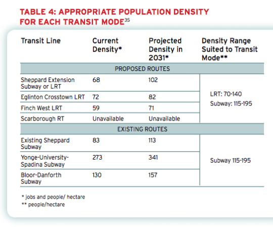
For subway they specify a minimum population density of 115 people per hectare and for light rail (LRT) they specify a minimum population density of 70 people per hectare.
And the reason for this is because there’s a strong correlation between population density (i.e. land use) and transit ridership. The two go hand in hand and should not be decoupled. If population densities are too low (as they are, for example, along the Sheppard subway line here in Toronto), people don’t take transit. They drive.
Here’s a chart from the report showing the current and projected population densities for Toronto’s existing and proposed routes (keep in mind this is from 2011).
So what does this chart tell us?
Subways don’t make a lot of sense in many parts of the city. LRT will do just fine.
The Sheppard subway line is an under-utilized asset. Even by 2031 we’ll barely be reaching the requisite population densities.
The Bloor-Danforth corridor could use more intensification.
Unfortunately, transit decisions are often made based on politics instead of data. And that results in subways in places that don’t make a lot of sense. That’s unfortunate because it means less riders, less revenue, and more subsidies.
The other challenge with running subways through low density neighborhoods is that it then creates tension when the city and developers go to intensify those neighborhoods through transit-oriented development. (See #DensityCreep.)
But if we’re going to be fiscally irresponsible about where we deploy our transit capital, the least we could do is upzone the surrounding areas and impose minimum population densities.
In fact, here’s what I think we should do: Land use should be bundled with the transit decision.
Instead of asking where the subway station should go, we should be asking where the subway station should go and all the density needed to bring the area up to a certain minimum population density. And if that second criteria for whatever reason can’t be met, then we don’t build the line.
I wonder if we framed the question in this way if it would change where subway lines get approved. What do you think?
In fact, land is not really scarce: the entire population of America could fit into Texas with more than an acre for each household to enjoy. What drives prices skyward is a collision between rampant demand and limited supply in the great metropolises like London, Mumbai and New York. In the past ten years real prices in Hong Kong have risen by 150%. Residential property in Mayfair, in central London, can go for as much as £55,000 ($82,000) per square metre. A square mile of Manhattan residential property costs $16.5 billion.
And part of the reason this has become so prevalent is because of the shifts we’ve seen in our economy and the great return back to cities.
In the 20th century, tumbling transport costs weakened the gravitational pull of the city; in the 21st, the digital revolution has restored it. Knowledge-intensive industries such as technology and finance thrive on the clustering of workers who share ideas and expertise. The economies and populations of metropolises like London, New York and San Francisco have rebounded as a result.
So how do we get better at meeting real estate demand in our cities? The Economist has two suggestions.
One:
First, they should ensure that city-planning decisions are made from the top down. When decisions are taken at local level, land-use rules tend to be stricter. Individual districts receive fewer of the benefits of a larger metropolitan population (jobs and taxes) than their costs (blocked views and congested streets). Moving housing-supply decisions to city level should mean that due weight is put on the benefits of growth. Any restrictions on building won by one district should be offset by increases elsewhere, so the city as a whole keeps to its development budget.
Two:
Second, governments should impose higher taxes on the value of land. In most rich countries, land-value taxes account for a small share of total revenues. Land taxes are efficient. They are difficult to dodge; you cannot stuff land into a bank-vault in Luxembourg. Whereas a high tax on property can discourage investment, a high tax on land creates an incentive to develop unused sites. Land-value taxes can also help cater for newcomers. New infrastructure raises the value of nearby land, automatically feeding through into revenues—which helps to pay for the improvements.
These recommendations will probably be unsettling for a number of people.
I would imagine that many communities would prefer to have planning and growth decisions happen bottom up, as opposed to top down. But I think there’s some truth to this recommendation and I don’t think it has to mean completely excluding bottom up feedback. Communities and individuals are naturally going to look out for their own self-interests. And so I think many would agree that there’s value in having a holistic urban strategy in place.
Recommendation number two pertaining to land value taxes is a loaded one. So I’m going to save my specific comments for a dedicated post on LVTs.
But I will say that I don’t think trying to squeeze landowners into development via taxes is the most efficient and immediate way to address supply shortages. In advance of this, we should be examining the current barriers to development. Because we’re talking about hyper competitive global cities with perpetual supply deficits. And I don’t believe the problem is incentive-based. The problem is finding sites. The problem is finding ways to build.
What do you all think? This is an interesting topic of discussion.
Established in 1627 in New France, the seigneurial system was a feudal way of distributing land and creating subsistence farming for those who occupied it. It was ultimately abolished in 1854, but you can still see vestiges of it.
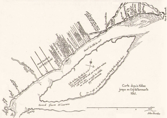
With the seigneurial system, a typical farming lot was a long and narrow strip of land emanating from the water, which in this particular case was the St. Lawrence River. Here’s a map from 1641 showing what that looks like:
The reasoning behind this spatial arrangement was rather simple. By having long narrow lots, it meant that you could maximize the number of farmers who had direct access to water. This was needed for navigation, but also for many other obvious reasons. This was an efficient layout.
At the same time, the long strips meant that each farmer had access to a broad cross section of different kinds of land. They had fertile land for growing, land for their home, and frequently land with trees so that they had material to build, fuel to burn, and so on. It also meant that, despite the overall lot sizes, people actually lived fairly close to each other. It created communities.
Of course, there’s a lot more to the seigneurial system than just its physical form and there are reasons it was eventually abolished. But today I just want to focus on spatial layout. Because I think there are parallels to how we continue to plan our communities.
If you live in a city you’ve probably come across a narrow rowhouse, a narrow townhouse, and/or a long and narrow condominium – which many people like to pejoratively refer to as a “bowling alley” plan. In these cases, the width of the home could be somewhere between 10 and 13 feet.
If you stop and think about this, it’s exactly the same spatial principles as the seigneurial land use system. But instead of maximizing the number of people with access to the St. Lawrence River, it’s about maximizing the number of people who front onto the street and who have access to natural light.
In tight urban conditions, it’s not uncommon to have no “side yard windows.” In my case, I live in a condominium with 20′ feet of windows on one side only. The other 3 sides of my box have none. And that’s a fairly common urban condition.
I find this interesting because as much as the world is rapidly changing, some things don’t actually change all that much.
The article talks about some of the transit-oriented development that we’ve seen at various nodes along Toronto’s Yonge subway corridor (St. Clair, Eglinton, Sheppard, and so on). But it goes on to argue that these are exceptions to the rule. For the most part, we’ve missed the boat:
The tragic history of our massive capital investments into transit infrastructure is massive under-development.
Indeed, the Bloor-Danforth subway corridor is a land use crime scene.
His main argument is that until we expand the supply of transit-oriented land (through increased intensification), we will continue to undersupply the kinds of walkable and transit-oriented neighborhoods that many, if not most, people actually prefer. And that, out of necessity, will force people into their cars. Because affordability trumps location preference.
As one example, he talks about the intersection of Bloor Street and Dundas Street in the west end of the city. Next to Union Station, this is probably the best connected mobility hub in the region. You have the Bloor-Danforth subway line, a streetcar line, and a GO regional rail line which all feed into it. Next year it’ll also become a stop for the new express train to Pearson airport.
And yet the city has a history of opposing intensification in this location, including the old Giraffe Condominiums proposed by TAS. Does that make sense to you?
If you’re a regular reader of Architect This City, you’ll know that I’m a big supporter of public transit. And that’s because, as far as I can tell, it’s the most efficient way of moving lots of people around a big city.
But more and more I’ve been thinking about how technology might change, or even disrupt, this school of thought. Which is why when I wrote this post a few days ago, I was careful to say that private cars aren’t the mobility answer. Because in reality, cars likely aren’t going to go away. We’re just going to use them differently.
Here are the two things I’m thinking about most:
1. Driverless cars
I’ve written about driverless cars before in terms of how they might be used as a form of public transit. But I think it’s worth revisiting them for a moment. There are lots of driverless car critics out there and they usually fixate on the fact that a car is still a car, whether or not you happen to be driving it. It still takes up the same amount of space in our cities. Or does it?
The key thing to keep in mind is that when we’re not longer driving the vehicle, it opens up lots of different possibilities in terms of how they might be used and also how they might be designed. I was watching this fireside chat with the founders of Google the other night and, for them, driverless cars offer the possibility of solving two big problems: traffic and parking.
We know that parking takes up a lot space in our cities. But that’s really symptomatic of the fact that the utilization rate for most people’s cars is incredibly low. Most of the time a car is sitting parked and idle. But with driverless cars, they’ll be able to drop you off at your destination and then continue on to pick up their next ride–thereby minimizing the need for all that parking.
This would bring the utilization rate way up for each car, which would also minimize the number of absolute cars that we’d need to have in our cities to move everybody around. Of course, this would mean that we’d be sharing cars. People wouldn’t own cars; they would be an on-demand service.
2. Networked vehicles
This brings us to my second point: driverless cars will be networked cars. Again, I’ve written about this before, but I specifically wanted to raise it again because of a new service that Lyft just launched in San Francisco called Lyft Line.
The way it works is simple. You input where you’re going and Lyft will match you up with others who are going to more or less the same destination. The routes get shared and this brings down the costs to everyday use. It runs on the same principles as the on-demand minibuses I wrote about in Helsinki.
But if you combine this with driverless cars, you’re starting to get at something incredibly interesting. Now all of sudden you’re getting the door-to-door convenience of private cars with many of the efficiencies of public transit.
So in my mind, it’s very possible that platforms like Uber, Hailo, and Lyft could became major infrastructure backbones in a world of driverless cars. And if you think about it in this context, then I don’t think the valuations for these companies should seem all that surprising. These are potentially huge innovations.
In the end, I don’t know how this will all shake out. I don’t think anybody does. I believe that strong public infrastructure (such as subways, light rail, and so on) will still be needed in big cities, but I’m starting to think that mobile apps and driverless cars will also form a big part of how we get around. Probably more so than most people think today.
The City of Toronto recently started an initiative called “Comprehensive to the Core.” It’s a look at how downtown Toronto–which is growing at 4 times the rate of the rest of the city–should continue to grow moving forward so that it remains a great place to live, work, learn and play.
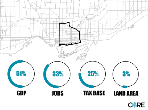
Here’s a presentation that was delivered last month by the city. It’s mostly infographics and so it’s a quick and fun read. And here’s an infographic that does a nice job of summarizing what’s happening in the core of Toronto.
What it’s saying is that downtown Toronto–which they consider to be bound by Bathurst Street in the west, the Don Valley Parkway in the east, the lake in the south, and Dupont Street in the north–is responsible for 51% of the city’s entire GDP. It’s also responsible for 33% of all jobs in the city and 25% of the city’s entire tax base. And yet in terms of size, it represents only 3% of the city’s land area.
That’s a powerful reminder of the economic potential of density and agglomeration economies. It’s also a reminder that we shouldn’t let politics deprive our economic engine of the services and investments it needs.