Daily insights for city builders, delivered every morning at 6 AM ET. I’m Brandon Donnelly — a Toronto-based real estate developer and founder of Globizen. I’ve been writing here since 2013.

Tag: lagos

  • Largest cities in the world — revisited

    Following my recent post about the largest cities in the world (from 100 to 2015 CE), a number of you rightly pointed out that the data looked questionable. Where, for example, is Shanghai in this latest list of largest cities? So I think it’s important that I do a follow-up post.

    There are a number of nuances to consider when trying to measure urban populations. Perhaps the two most obvious are the geographic extent of each city (i.e. what urban boundary do you use) and the number of people living in informal settlements.

    The UN recently estimated that there are some 1 billion people living in slums or informal settlements. That represents nearly a quarter of the world’s urban population, which is a staggering number and a pressing global need. We desperately need more housing.

    When it comes to measuring the size of an urban agglomeration, most of the studies that I have seen tend not to focus on municipal boundaries (“city propers”) or metropolitan areas. The former is often based on arbitrary political boundaries and the latter often contains undeveloped rural land.

    So for the purposes of this post, I’m going to go with Demographia’s definition of “built-up urban area.” They define this as being a continuously built-up area with one labor market and with no rural land. In their view, the world is either urban/built-up or rural. The built-up part is the lighted area that you would see on a nighttime satellite photo.

    Given this definition, there are a number of interesting fringe cases. For example, contiguous/adjacent urban areas with more than one labor market get split up into multiple ones. This is the case in the US with the northeastern “megalopolis” that runs from Boston to Washington.

    Conversely, if adjacent urban areas share a labor market and are linked together by similar commuting flows, then they get grouped into one urban area. This might be the case even if the area(s) straddle a national border. In this particular case, the free movement of people and goods would be another prerequisite.

    With these definitions out of the way, below is another stab at sharing an accurate list of the world’s largest megacities or built-up urban areas. This is one is by Demographia and there are a number of key changes compared to the last one I shared. Shanghai now features in the top 10. But Lagos drops down to number 20, which remains a bit of a question mark for me.

    For a copy of Demographia’s full report, click here. It looks at all urban areas with a population greater than 500,000 people (total is 985). Of course, if any of you have any other data sources that you think I should take a look at, feel free to share them in the comment section below.

  • Largest cities in the world from 100 to 2015 CE

    I just discovered this set of maps (via Brian Potter) looking at the largest cities in the world from 100 CE all the way through to today (well 2015 CE). Here are what the two bookends of this map series look like:

    It is an interesting reminder of just how centralized the world was around the Mediterranean and parts of Asia, and also how nothing is guaranteed. As recent as 1900, cities like Manchester and Philadelphia were among the top 10 largest cities. Today they aren’t even close.

    For the full map collection, click here.

    UPDATE: The data behind these maps has been called into question. Look out for a follow-up post.

  • The 100 million city

    The Guardian recently published this reminder that the real population growth in the world today is happening in Asia and Africa. The article is called, “The 100 million city: is 21st century urbanisation out of control?” Much of the data is from this 2016 paper by Daniel Hoornweg and Kevin Pope, which projected the populations of the world’s biggest cities by 2100.

    The standout example is that of Lagos, Nigeria, which went from under 200,000 people in the 1960s to an estimated 20 million people today. Though, I would imagine that the ubiquity of informal settlements makes it difficult to come up with an accurate number.

    Still, it is one of the world’s top 10 largest cities and, by 2100, it may be the largest city in the world. The Guardian described the population as young, fertile, and increasingly urban. The median age in Nigeria is 18 and the fertility rate for the content is 4.4 births per woman.

    I am mentioning all of this today because I think it grants some perspective. This is an immense city building challenge, not only because of the unprecedented growth rate, but also because it remains largely poor. Lagos, a city, may add more than 2.2x the population of Canada, a country, during the balance of this century.

  • The top 10 mega-cities by 2030

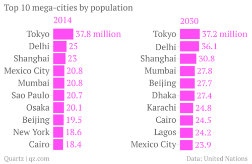
    One of the reasons I’m so fascinated by cities is that it’s becoming increasingly more important to get them right. From about 1831 to 1925, London was the largest city in the world. Its population went from somewhere around 1.5 to 2 million people to nearly 7.5 million. London surpassed Beijing as the largest city and was then surpassed by New York.

    Today our largest cities are significantly bigger. Tokyo has almost 40 million people and London doesn’t even make the top 10. But there’s also a broader shift taking place. According to a new report by the United Nations, most of the world’s largest cities will be in Africa and Asia by 2030. Here’s a chart from Quartz:

    image

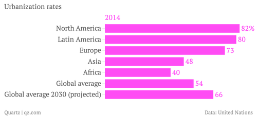
    And the reason for this shift is because Asia and Africa are newly urbanizing, whereas the rest of the world has already urbanized. In North America, over 80% of people already live in cities.

    image

    But even though Asia and Africa are following a trend that has already taken place in the rest of the world, it doesn’t mean we should assume we know what we’re doing. Having spent time in cities like Dhaka, I can attest to the many challenges that these mega-cities are facing and will continue to face as people flood in from the rural areas looking for economic opportunities.

    So while it’s important that we talk about strategies for reviving cities like Detroit – which has a population somewhere around 700,000 – 800,000 people – we should also keep in mind that we have some significant challenges ahead of us in terms of creating a sustainable urban planning agenda for the world.

  • How Facebook is using its data to analyze global migration patterns

    More and more people are moving to cities. This much we know. But in our fast paced world, census data is becoming increasingly limited in its ability to tell us exactly where and how people are moving.

    Thankfully we now have Facebook. 

    image

    I just discovered a fascinating study conducted by the Facebook Data Science Team called “Coordinated Migration.” What they did was anonymously analyze every Facebook user that has inputted both a hometown and a current city to see where people of a particular hometown are most likely to live, today.

    But more specifically, the study is looking at coordinated flows, rather than just total flows to a particular city. A “coordinated migration” is defined as an instance where “a significant proportion of the population of a city has migrated, as a group, to a different city.”

    What the study found (perhaps not surprisingly) was that the vast majority of coordinated migrations are happening in countries that are in the midst of rapid urbanization. It’s a case of people moving within the country to its largest city.

    Here are the top coordinated migration destinations:

    If you’re interested in the nitty gritty of how they actually computed the coordinated migrations, check out the original post by the Facebook Data Science Team.