Daily insights for city builders, delivered every morning at 6 AM ET. I’m Brandon Donnelly — a Toronto-based real estate developer and founder of Globizen. I’ve been writing here since 2013.

Tag: infrastructure

  • How I moved over the last 3 weeks

    At the beginning of this year I wrote a post about a mobile tracking app called Moves that I had heard about through my friend Sachin Monga. He had just published a beautiful set maps showing where he physically spent his time in both Toronto and San Francisco.

    His post spurred me to download the app and at the end of my post I promised to share my own set of maps once I had collected enough data points. It’s only been about 3 weeks, but already my maps are starting to fill out, so I thought I would do a release.

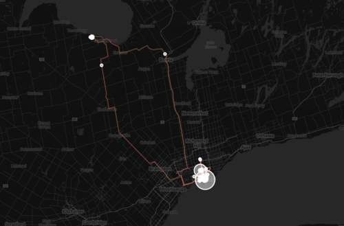
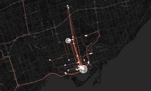
    The orange lines represent transport of some sort (car, subway, streetcar, and so on) and the green lines represent walking. I don’t cycle very often in the winter (I know, I’m a fair-weather cyclist), so you won’t see any of those lines just yet. However if I posted a map from the summer, I know it would look completely different.

    Here’s a first one showing a regional scale:
    image

    Here’s a second one showing the city of Toronto:
    image

    And here’s a third one showing mostly downtown:
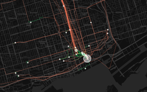
    image

    What’s interesting about these maps is how much you can tell about me and the way I move around the city.

    For one, there’s a good chance I ski or snowboard given that I’m driving up to Collingwood, Ontario in the winter. You can also see how heavily dependent I am on the Yonge subway line, which is the thickest orange line in the middle of downtown. It’s also interesting to see how localized I am within my neighborhood (St. Lawrence Market). I walk to get groceries. I walk to the gym. I walk to coffee. And the list goes on.

    This is fairly typical for people living in urban neighborhoods, but it would be interesting to see where it applies in the city and where it begins to fall apart. I would also imagine that there’s a correlation to the area’s Walk Score, although this (Moves) might actually be a better measure since it’s usage data.

    Either way, imagine what cities could do if they had this sort of data for every resident. They would be able to see precise resident flows and then determine exactly where transit and infrastructure investments should be made instead of politicking to determine where they should be made.

    That time is coming.
  • Leveraging LRT

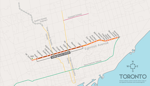
    One of the biggest pieces of infrastructure currently under construction in Toronto is the Crosstown LRT line, which will run on and under Eglinton Avenue right through the heart of midtown. The total length of the line is 19 km, and 10 km of it will be underground along with 12 of its stations.

    Here’s a map:

    image

    But as the Chief Planner of Toronto, Jennifer Keesmaat, rightly pointed out in this blog post earlier this year, it’s important to think of this line, not just as a piece of transit infrastructure, but as a broader city building initiative. With this line comes a tremendous opportunity to rethink and rebuild one of Toronto’s most important avenues.

    I have no doubt that this will happen over the coming years and decades. I mean, just look at the development activity taking place on St. Clair Avenue West right now, which you could argue is the result of its right-of-way streetcar line. But in this instance, what I’m specifically curious about is what will happen at each of the stations along Eglinton Avenue.

    If you take a look at the Stations and Stops page on the Crosstown website, you can see where all of the primary and secondary entrances will be and how each station will generally function. But what is not clear is whether we will be using this opportunity to build additional density on top of them.

    Here’s how they have “blocked out” the primary entrance for Avenue station:

    image

    I have no idea what it’ll become. But if it ends up as single-storey and single-purpose building, then I think we will have missed an opportunity. And the same goes for many, if not all, of the other stations along the Eglinton Crosstown line. Fixed rail is such a massive driver of real estate value, and so it seems silly not to take advantage of that in some way.

    If anyone has any insights into how these stations will or will not be developed, I would love to hear from you in the comment section below.

  • What makes a city a smart one?

    There’s a lot of buzz around the idea of a “smart city.” IBM is involved. Cisco is involved. And so are many others. But what exactly is a smart city? 

    In the Electric City talk below, Adam Greenfield provides his definition, while at the same time being critical of the ones we currently use today, such as this one: It’s the missing link – the connective tissue – between the real estate and technology sectors. (Personally, I find this definition really interesting.)

    He also goes on to argue that the way we’re largely thinking about smart cities today is incorrect. We’re far too centralized and administrative in our thinking. Instead, we should be focused on leveraging the crowds of people in our cities that are now virtually all networked.

    He then goes on to list 5 technological preconditions to any smart city:

    1. Broadband connectivity
    2. Low-cost smartphones or personal devices
    3. Commitment to open municipal data
    4. Cheap public interfaces
    5. Cloud computing infrastructure

    If you’re interested in this topic, I suggest you watch his talk. It’s only about 10 minutes long. Click here if you can’t see it below.

    [youtube https://www.youtube.com/watch?v=9keDwTBmZ3o?rel=0]

    Update: This post was revised to reflect the fact that Adam Greenfield is “sharply critical” of the real estate + technology definition of a smart city.

  • What we could do to improve traffic in Toronto

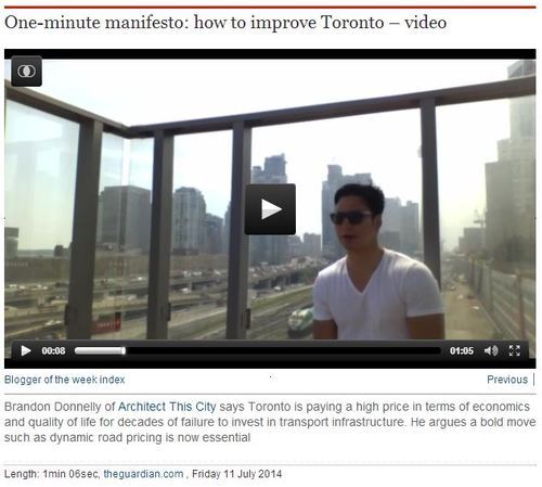
    This morning The Guardian Cities published my one-minute video talking about how much traffic sucks in Toronto and why we should be considering bold initiatives like dynamic road pricing.

    The video was shot on the sundeck of my building on a holiday Monday (meaning traffic volumes should have been less). The dirty glass makes the city look a lot smoggier than it really is, but it felt appropriate for the topic I was discussing.

    I’m sure many of you will disagree with what I’m advocting for, so let me know your thoughts in the comment section below.

  • Recommendation to remove the elevated Gardiner Expressway

    I’ve written a lot lately about the Gardiner Expressway East. First to argue that I think it should be torn down and, second, to provide a counter argument as to why some people think North America’s urban freeways are here to stay. I wanted to avoid confirmation bias.

    Well a recommendation has been made to City Council and it is, indeed, to remove the eastern portion of the Gardiner Expressway. They are now asking Council to approve it. The item will first go to the Public Works and Infrastructure Committee on March 4, 2014 and, subject to the results of that meeting, will then go to City Council on April 1, 2014. 

    The recommendation to Council identified the following 4 key features of the preferred “remove” option:

    1. Widening of Lake Shore Boulevard east of Jarvis Street by two lanes into an eight-lane landscaped at-grade boulevard;
    2. The lowest overall public investment at $240 million net present value (NPV) because of significantly lower lifecycle costs despite a higher upfront capital cost than Maintain;
    3. Public land disposition proceeds of approximately $80 to 90 million NPV from the release of about 4 hectares of land (which could support 260,000 square metres of development)
    4. Highest compatibility with Official Plan and Central Waterfront Secondary Plan principles and objectives as well as approved plans, such as the Don Mouth Naturalization and Flood Protection EA, Lower Don Lands Framework Plan, Keating Channel Precinct Plan and the Port Lands Acceleration Initiative.

    If you’d like to read more about what’s going to Public Works and City Council, click here.

    One thing I didn’t mention in my previous posts is the land disposition piece (item #3 above). By removing the Gardiner East, roughly 10 acres of public land will be freed up which, according to their estimates, could allow for 2.8 million square feet of new development. That’s roughly the size of our 72-storey First Canadian Place.

    I’ve been crystal clear about my position on the Gardiner East and so I’m delighted to see it seemingly move forward in that direction. I know a lot of people are concerned that the removal option could result in some commute times being 5 to 10 minutes longer by 2031, but I think we’ll have even bigger problems by 2031 if we continue with the status quo.

    Urban theorist Richard Florida has argued many times before that when cities get to around 5-6 million people they come to a point where they have to make tough decisions about the way they’re going to continue to grow and prosper. Toronto is at that moment. Our car dependent ways are already crippling productivity levels.

    What kind of city do we want to be by 2031? I don’t think that we can afford to just “maintain.”

  • Revisiting the Gardiner East debate

    Last week I argued that the eastern portion of the Gardiner Expressway (Jarvis Street over to the Don Valley Expressway) should be torn down and replaced by an enlarged Lake Shore Boulevard.

    To quickly summarize, here’s why I support removing the Gardiner East:

    • Now is the time to do it (before we develop the surrounding area and it becomes both more expensive and more difficult to do it).
    • It would go a long way to stitching our disconnected downtown back to the lake and realizing our ambitions for the revitalization of the waterfront.
    • Unlocking the full potential of our waterfront is hugely important.
    • In my opinion, the only way to build a big, well functioning city, is on the backbone of public transportation. And this—the tearing down of the Gardiner East—could represent that paradigm shift.
    • It is a portion of the Expressway that has relatively low traffic volumes.
    • It’s the cheapest option on the table.

    Somewhat surprisingly though, a lot of people disagreed with me. They told me that adding anything to our already long commutes would be simply unconscionable and that they would not support it, no matter how much it improved our waterfront.

    So in the spirit of avoiding confirmation bias (that is, only seeking out things that reinforce an already established belief), I thought I would share the following article: “Like It or Not, Most Urban Freeways Are Here to Stay.” It’s from Atlantic Cities and there are 3 key take-aways that I’d like to point out.

    First, I thought it was interesting that the interstate system in the United States was, from the onset, always conceived of as a solution to urban congestion. I always thought it was about connecting the country, but that, apparently, was a secondary goal.

    Second, cities all across North America are engaging in the same debate about what to do with their aging highways. Detroit is debating. New Orleans is debating. And so is Syracuse. Toronto is not alone. But we could be alone in taking the lead on this issue.

    Third, the author basically acknowledges that, while not ideal, we’re stuck for the time being with all these freeways and that the better solution is going to be a really tough slog:

    “This is not an easy assignment, seeing as how cars are purchases we make with our hearts, more than our heads. Logic won’t convince Americans to change their ways. What will? Maybe, over time, prohibitive fuel prices and withering tolls, and, most importantly, investment in useful and convenient public transit. Only when the carrot is irresistible, and the stick stings too sharply to bear, will the shift begin, and it will take years to play out.”

    And while I would agree that it’s not going to be easy, that’s par for the course with anything truly worthwhile. If it were easy, everyone would be doing it. But they’re not. And that’s why there are leaders and there are followers.

    People in Toronto like to talk about how our City sometimes lacks vision. Well, here’s our chance. I’m not worrying about what the commute is going to be like tomorrow, because I know there’s an even better solution for that problem. I’m worried about something even bigger. I’m worried about the kind of city we’re all going to leave behind to our children.

  • A question of infrastructure

    One of the main reasons why I hear people oppose certain development projects is because of a lack of infrastructure. Whether it’s roads, transit or something else, the concern is that what we have is inadequate to service what we’re about to build.

    Now, I understand that we can’t completely overburden the city, but I still have fundamental concerns with this line of thought. 

    The population of the Greater Toronto Area is expected to grow by 2.5 million people over the next 20 some years, to almost 9 million people by 2036. What this means is that growth is happening and it doesn’t really care whether or not we have the “right” infrastructure in place. It’s coming and we need to figure out how best to house these people while at the same time building the most livable and prosperous city on the planet.

    And I’m not sure most people appreciate that if we don’t build up (intensification) it means we’re going to be building out (sprawl). Again, the growth isn’t going to stop. And this represents an even greater strain on our region’s infrastructure (both built and natural) because it puts people into less intense land use and into cars.

    So what I’m going to suggest is that instead of asking if our current infrastructure will handle the future, we ask why the future hasn’t been built into our current infrastructure? It’s a question of being proactive, rather than reactive.

    We should be demanding better infrastructure instead of holding back progress because of our inability to properly city build. We should be demanding the best as opposed to knocking everything else down to the lowest common denominator.

    A perfect example of this is transit.

    I strongly believe that transit is one of, if not the, biggest issue facing our region today. Decades of disinvestment are really showing my friends. And if we don’t get our act together, the impact on our quality of life, our environment, and our economic productivity is only going to worsen.

    We need to be asking the right questions: Is the development the problem or is the real problem our infrastructure deficit?

  • Transit rant

    Transit planning is absolutely and utterly broken in Toronto. Over the past few years, it has become abundantly clear that our current methods are completely ineffectual. We’re entirely useless at delivering transit infrastructure to the most important economic region in Canada. 

    The process is deeply political, and with all three levels of government involved, as well as countless agencies, we’re getting absolutely nothing done. And when we do manage to achieve some level of progress, such as provincial funding for the Scarborough subway line, it turns out that fact and evidence would suggest we’re actually headed in the wrong direction.

    It’s an unfortunate situation that we’ve gotten ourselves into, because transit and infrastructure have such a profound impact on productivity levels and our economy as a whole. And yet we’re just sitting back while our politicians fight over transit investment according to what best suits their voter bases.

    Politicians should not be making these decisions. At this point they’ve proven their inability to make effective progress and so I believe we need to strip them of this responsibility. Part of the problem is that we have a mismatch of time horizons: politicians need quick wins, while transit investment is a long term game.

    What we need is an entity – ideally one entity – that isn’t reliant on ad hoc funding hand outs. It needs a sustainable funding source and the power to make decisions about where infrastructure investments will be made in our region. We can’t continue to screw this up. Transit is far too important.

  • Subways – except the downtown relief line

    Politics rewards consistency. Even if you’re wrong, it’s better to be consistently wrong than come across as wavering – however noble and rational the intentions may be. And that’s exactly what happened with Rob Ford and his commitment to subways, subways and subways.

    John Lorinc of Spacing wrote an interesting piece yesterday on how, despite all the debating that went on, Ford is delivering what he said he was going to deliver: a subway. It doesn’t matter that all technical and financial considerations were thrown out the window, he got it funded.

    As I said earlier this week, I think the Scarborough line is the wrong subway to be building and that the downtown relief line is infinitely more important for the region. However, Lorinc makes a good case in his article for why this line will not be funded despite the current focus on subways, subways and subways:

    Fourth, it’s important to recognize that there will be one notably perverse exception to the foregoing, which is the [Insert Euphemism Here] Relief Line. I do admire Josh Matlow’s advocacy on this front. But Ford will never take up the DRL cause because (i) he doesn’t get the purpose of said extension; and (ii) because the project doesn’t butter his bread, electorally speaking. I’m guessing it will be years before someone with the mayor’s block-headed tenacity emerges to champion a line with a politically inconvenient name and an eye-bulging price tag.

    In fact, the sheer heft of the relief line will allow marginally useful yet politically supported subway projects — extensions in the west end to Sherway Gardens or up Yonge to Richmond Hill – to continue to elbow their way to the front of the line, just exactly as the Scarborough subway project did. Indeed, because we no longer care, at any level of government, about subjecting our transit investment choices to a rational policy framework, the most crucial project in the GTA will always lose out in the funding lottery because it has the most diffuse constituency and the most conceptually complicated purpose.”

    The disparaging thing about these two paragraphs is that it’s a sad reality.

  • javinlau:

    in.fra.struct.ure.

    a familiar view.

    www.javinlau.com