Daily insights for city builders, delivered every morning at 6 AM ET. I’m Brandon Donnelly — a Toronto-based real estate developer and founder of Globizen. I’ve been writing here since 2013.

Tag: infrastructure

  • How much is development land worth?

    As we have talked about many times before, the best answer to this question is that it’s worth whatever money is left in your pro forma once you’ve accounted for everything else. This is what is called the “residual claimant” in a development model. And it means you start with your revenue, you deduct all project costs, including whatever profit you and your investors need to make in order to take on the risk of the development, and then whatever is left can go to pay for the land.

    This is the most prudent way to value development land; but of course, in practice, it doesn’t always work this way. In a bull market, the correct answer to my question might be, “whatever most market participants are willing to pay.” And sometimes/oftentimes, this number will be greater than what your model is telling you, meaning you’ll need to be more aggressive on your assumptions if you too want to participate. (Not development advice.)

    Given that determining the value of land starts with revenue, one way to do a very crude gut check is to look at the relationship between land cost and revenue. This is sometimes called a land-to-revenue ratio. And historically, for new condominiums in Toronto, you wanted a ratio that was no greater than 10%. Meaning, if the most you could sell condominiums for was $1,000 psf, then the most you could afford to pay for land was $100 per buildable square foot.

    However, this is, again, a very crude rule of thumb. I would say that it’s only really interesting to look at this after the fact. Because in reality, things never work this cleanly. For one thing, there is always a cost floor. Don’t, for example, think you can buy land in Toronto for $80 pbsf and sell condominiums for $800 psf, because this will not be enough to cover all of your costs. You will lose money.

    Secondly, there are countless variables that have a huge impact on the value of development land. Things like a high required parking ratio, development charges and other city fees, inclusionary zoning, and so on. All of these items are real costs in a development model, and so they will need to be paid for somehow.

    Typically this happens by way of higher revenues (in a rising market), a lower land cost (in a sinking market), or some combination of the two. But in all of these cases, it means your land-to-revenue ratio must come down to maintain project feasibility. This is why suburban development sites typically have a lower ratio — too much loss-leading parking, among other things.

    Of course, there are also instances where the correct answer could be a land-to-revenue ratio approaching zero, or even a negative number. In this latter case, it means your projected revenues aren’t enough to cover all of your other costs, excluding land. For anyone to build, they will require some form of subsidy. And this is basically the case with every affordable housing project. They don’t pencil on their own. (For a concrete example of this, look to the US and their Low-Income Housing Tax Credits.)

    So once again, the moral of this story is that the best way to think about the value of development land is to think of it as “whatever money is left in the pro forma once you’ve accounted for everything else.” Because sometimes there will be money there, and sometimes there won’t be.

    Photo by Jannes Glas on Unsplash

  • Phase one of Montreal’s REM is now open

    The first phase of Montreal’s new Réseau express métropolitain (or REM) just opened it up. It is a 17 km light-rail line that includes five stations running from Brossard in the south (A1 above) to Gare Centrale in downtown Montreal. Eventually this network — which is distinct from but connected to the city’s existing metro network operated by STM — will span 67 kilometers and have a total of 26 stations. To put this into perspective, Montreal’s current metro totals 69.2 kms. So this is a near doubling.

    As with most big city building projects, Montreal’s REM is being and will continue to be criticized. Back in 2016, the project had an estimated total project cost of $5.9 billion. By 2021, this number had increased to $6.9 billion. Today, who knows what the number will be. But it will be more. The reality is that everything went up, by a lot, over the last five years. During the pandemic, we were seeing 30-40% cost increases on some of our construction line items.

    What’s perhaps most noteworthy about this project is its delivery model. It is being delivered through a partnership with the the Caisse de dépôt et placement du Québec (CDPQ):

    Under the pact, the Caisse’s infrastructure arm is assuming $3.5-billion of the project’s $6.9-billion construction cost while Quebec is committing $1.28-billion and the Canada Infrastructure Bank is providing a $1.28-billion loan. The balance consists of a $295-million payment from Hydro-Québec for the line’s electrification, while the Autorité régionale de transport métropolitain, the transit authority for the Montreal region, is pledging $512-million.

    Provincial and local governments will provide continuing operating subsidies for the REM to make sure the Caisse earns its required return on the project, currently pegged at 8 to 9 per cent. The pension fund manager will get 72 cents for each passenger-kilometre travelled on the light rail system. Without such a subsidy, fares would climb to a level few passengers could afford.

    It’ll be interesting to see how this approach stands the test of time. As I understand it, CDPQ wants to continue building and operating transit in other cities around the world. I don’t know any of the specifics other than what I have read online. But from the outside, things seem to be working. The first phase of the REM broke ground in April 2018, and the opening ceremony was held this month (July 2023). That’s basically warp speed in transit timelines.

    Map: Montreal REM

  • The longest outdoor escalator system in the world

    This morning I took the mid-level escalators down to Hong Kong station so that I could catch the express train to the airport. At over 800m, it is supposedly the longest outdoor covered escalator system in the world.

    If you’ve ever walked the streets of Hong Kong you’ll know that the ground plane can be inhospitable at times. There’s limited space, but no shortage of steep pitches. I can’t imagine having a physical disability and trying to navigate this city.

    So this system must have been a real innovation when it was constructed in the early 90′s. In total it moves up and down about 135m in elevation. That’s about the equivalent of a 45 storey tower. And I got down from the mid-levels and was on a train to the airport within 15 minutes.

    But because the streets here are so narrow it’s a unidirectional system with one line of escalators. They bring people down to the CBD during the morning rush, but then the direction flips and they bring people up the hill for the remainder of the day — until midnight I believe. Living near these escalators is considered a win.

    Hong Kong Island surely isn’t the easiest of environments in which to build and operate one of the world’s most important global cities. There’s relatively little developable flatland. But they more than made it work by being creative and by building up. Hong Kong is not just a tall city, but a truly vertical city.

    Too bad my efficient morning commute was followed by a cancelled United flight. Tomorrow is not going to be a fun day travel.

  • Lessons in transit success

    image

    Dylan Reid of Spacing was recently at the International Transport Forum in Leipzig, Germany and has been publishing some interesting posts related to transit. Here is one about what makes transit systems succeed and fail.

    I really like the point that we too often think about transit projects as culminating with a big opening, while overlooking the importance of operations. It’s a bit like focusing on the wedding ceremony and forgetting that the ceremony is only really there to (hopefully) mark the beginning of a lifelong union.

    One of the reasons why this is important is because, as Reid points out, “fares need to provide a strong and consistent proportion of the agency’s funding.” So you need bums in seats, which means you need to build the right transit in the right locations. In other words, a new subway line through a low density suburb will probably result in an abysmal farebox recovery ratio.

    At the same time:

    “…fares will rarely cover all of an agency’s costs. Hong Kong’s Kam noted that, to be truly autonomous, an operator needs an additional dedicated, independent source of revenue. This cannot be based on additional transit-related non-fare revenue (e.g. advertising) – such revenue is helpful but never significant. It needs to be an external source. In Hong Kong, it is based on the agency’s extensive property ownership, but in other cities it could be a congestion charge, a dedicated sales or income tax, or other mechanism. Only with such a source can the agency have the independence to make its own choices for reinvestment and improvements.”

    This is one of the reasons why I am such a strong supporter of road pricing.

    Another point that Reid makes is that transit agencies should always have a consistent pipeline of new projects, rather than erratic periods of expansion. This makes a lot of sense given what it takes to ramp up for a large infrastructure project. But it’s obviously contingent on having sustainable funding sources.

    Click here if you’d like to read the rest of Dylan Reid’s post.

  • America’s urban infrastructure — what to do?

    The Penn Institute for Urban Research recently asked a dozen experts to weigh in on the topic of urban infrastructure in the United States. More specifically: What should the US do? It is a direct response to President Trump’s inauguration speech, where he described America’s infrastructure in terms of “disrepair and decay.”

    The urban experts include Eugénie L. Birch, Saskia Sassen, Susan Wachter, Richard P. Voith, and many others. Richard Voith’s piece is called, Historical Patterns of Infrastructure Funding. (I was his teaching assistant while I was at Penn and I still follow his work.) 

    I found it interesting how infrastructure funding has shifted from the federal level to the local municipal level – especially in the realm of public transit. Given the rise of urban centers, this makes intuitive sense. But Voith also argues that “relying only on local funding of transportation will almost certainly result in an under supply of infrastructure.”

    For the full Expert Voices series, click here. I think many of you will like it.

  • Winter Wonderland (and 3 things to read)

    This is what it looks like in Mont-Tremblant right now:

    It’s currently -11 degrees celsius and it’s expected to snow for most of the day. It’s starting to come down right now. But this evening it’s supposed to warm up to +1 degrees celsius, which means it may turn into (freezing) rain. I hope we see a lot more snow than rain. Nobody wants an icy mountain.

    If you’re looking for things to read this morning, here are 3 pieces:

    1. In American Towns, Private Profits From Public Works. It’s a NY Times article talking about how cash-strapped towns are turning to private equity firms to pay for their infrastructure. 

    2. How Zoning Laws Shaped New York City Over the Last Century. This is about an exhibition being held at The Museum of the City of New York right now. The rules we make shape our built environment. Thanks John for the link.

    3. Authenticity, and how Snapchat is banking on it. I am very fascinated by Snap Inc.’s ability to think differently and adopt counterintuitive business strategies. There’s also a cultural dimension to all of this.

  • The Scarborough Subway Extension is a mistake

    Last weekend over dinner, a friend of mine asked me what I thought about the Scarborough Subway Extension debate going on in Toronto right now. Costs are coming in higher than initially projected and the usual back and forth is taking place. Transit blogger Steve Munro has a good post on this called Spinning a Tale in Scarborough.

    I haven’t written much about the Scarborough Subway, but I do have a strong opinion. I believe it’s a mistake. I am not saying that we shouldn’t be building higher order transit in Scarborough – we absolutely should – but it does not need to be an expensive subway line. There are more sensible solutions.

    Here are a few things to consider:

    Light rail transit (LRT) does not equal streetcar. As an avid user of the King streetcar, I’ll be the first to admit that something needs to be done to address the city’s busiest streetcar routes. They are broken. But this is not what was being previously contemplated for Scarborough. True LRT – which Toronto does not yet have – is far more effective at moving people.

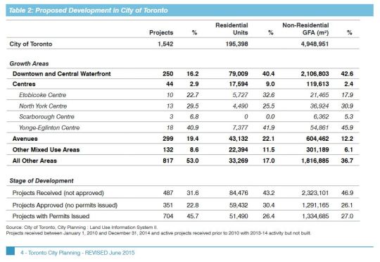
    Scarborough Centre is seeing almost no new residential and commercial development. In fact, the “Centres” in general are not seeing much development. The largest share is happening downtown, along the central waterfront, and along the “Avenues.” We shouldn’t ignore this when making our investment decisions. Transit and built form go hand in hand. 

    I also do not buy the argument that we are building this subway in anticipation of demand 50 or 100 years from now. We are not in a position to be proactive about our infrastructure. We are desperately playing catch up and there are already lots of high growth and high density areas in the city which today are completely underserved by higher order transit. 

    Finally, a new subway line with low ridership will mean higher operating cost subsidies to keep it afloat. And at the rate that Scarborough Centre is growing today, this would likely continue for many years into the future. Not only is this debate about spending money today, it is about spending money well in the future, month after month.

    So let’s be clear: the Scarborough Subway Extension debate is about politics. It is not about transportation planning.

  • How megacities are changing the map of the world

    In advance of his new book, titled Connectography, Parag Khanna recently delivered an interesting TED Talk called, How megacities are changing the map of the world. It’s about 20 minutes long.

    A lot of what is covered won’t be new to this audience, but I like how he talks about the importance of urban connectivity, the shift from political to functional geography, and the idea that, in a megacity world, countries can actually be the suburbs of some cities.

    One thing you might notice about the talk is how he glosses over both Canada and Europe. This is a reminder to me that if Canadian cities are going to continue to compete against the emerging megacities of the world, we are going to need to think at the scale of the megalopolis. And a big part of that means a focus on extra-urban connectivity.

    Click here if you can’t see the embedded talk below.

    https://embed-ssl.ted.com/talks/parag_khanna_how_megacities_are_changing_the_map_of_the_world.html

  • Toronto’s rapid transit network by 2031

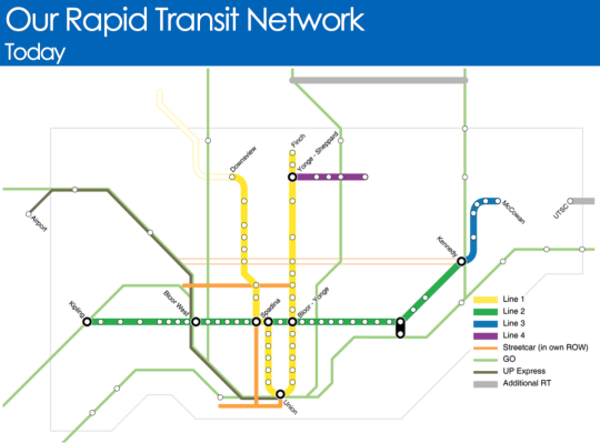
    Starting today and running until the end of March, the City of Toronto, the Toronto Transit Commission, and Metrolinx will be hosting several public meetings as they work towards planning out this city and region’s rapid transit network.

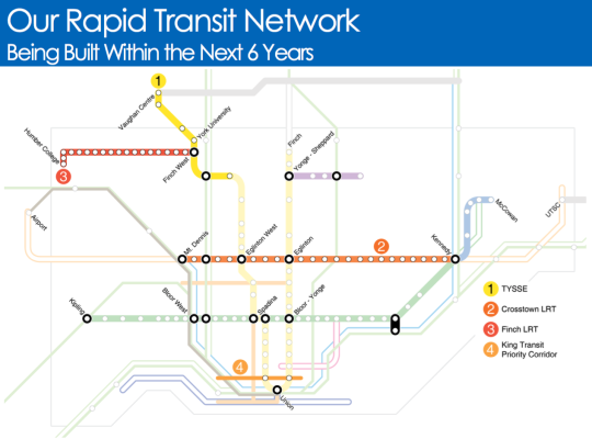
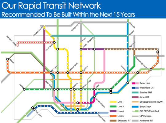
    Below are a few of the key maps from their presentation.

    Here is what Toronto’s rapid transit network looks like today (the hollow lines represent projects in construction):

    image

    Here is what will be built within the next 6 years:

    image

    And here is what they are recommending should be built within the next 15 years:

    image

    It’s hard not to get excited when you see maps like this. Of course, it’s a lot easier to draw lines on a map then it is to fund and execute on projects like this.

    But I think it all starts with us acknowledging that these initiatives are critical to both our economic competitiveness as a city region and our quality of life as citizens of it. Because if this is something we really want, then we can absolutely make it happen.

    Click here if you’d like to see the full presentation and also the public meeting dates/times.

  • The case for planning transit around minimum population densities

    Photograph Blitz by Tristan O'Tierney on 500px

    Blitz by Tristan O’Tierney on 500px

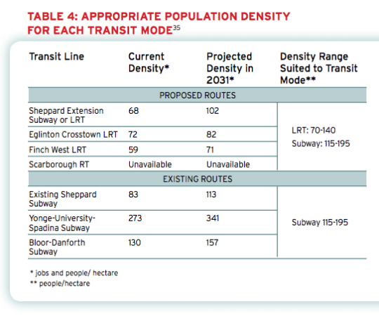
    Back in 2011, the The Pembina Institute published a report called, Building transit where we need it. And in it they quite clearly outlined the population densities that are needed to make various types of transit investment cost effective.

    For subway they specify a minimum population density of 115 people per hectare and for light rail (LRT) they specify a minimum population density of 70 people per hectare. 

    And the reason for this is because there’s a strong correlation between population density (i.e. land use) and transit ridership. The two go hand in hand and should not be decoupled. If population densities are too low (as they are, for example, along the Sheppard subway line here in Toronto), people don’t take transit. They drive.

    Here’s a chart from the report showing the current and projected population densities for Toronto’s existing and proposed routes (keep in mind this is from 2011).

    image

    So what does this chart tell us?

    • Subways don’t make a lot of sense in many parts of the city. LRT will do just fine.
    • The Sheppard subway line is an under-utilized asset. Even by 2031 we’ll barely be reaching the requisite population densities.
    • The Bloor-Danforth corridor could use more intensification.
    • The Yonge-University-Spadina line is going to need to relief.

    Unfortunately, transit decisions are often made based on politics instead of data. And that results in subways in places that don’t make a lot of sense. That’s unfortunate because it means less riders, less revenue, and more subsidies.

    The other challenge with running subways through low density neighborhoods is that it then creates tension when the city and developers go to intensify those neighborhoods through transit-oriented development. (See #DensityCreep.)

    But if we’re going to be fiscally irresponsible about where we deploy our transit capital, the least we could do is upzone the surrounding areas and impose minimum population densities. 

    In fact, here’s what I think we should do: Land use should be bundled with the transit decision. 

    Instead of asking where the subway station should go, we should be asking where the subway station should go and all the density needed to bring the area up to a certain minimum population density. And if that second criteria for whatever reason can’t be met, then we don’t build the line. 

    I wonder if we framed the question in this way if it would change where subway lines get approved. What do you think?