Daily insights for city builders, delivered every morning at 6 AM ET. I’m Brandon Donnelly — a Toronto-based real estate developer and founder of Globizen. I’ve been writing here since 2013.

Tag: globe and mail

  • Spaces between buildings

    Doug Saunders recently published a great piece in the Globe and Mail about the “the dead spaces between buildings” and the architectural revolution that is taking place from Mexico City to Toronto to solve this underappreciated problem.

    The example in Mexico City is that of the San Pablo Xalpa public housing complex where architect Rozana Montiel transformed the underutilized spaces between the apartment buildings into vibrant “common-unity” spaces. 

    This meant removing 95% of the fences and gates that had previously been erected as safeguard against the unsavory people and acts that were taking place in these open spaces.

    The underlying goal was to try and address the socioeconomic decline that had taken root in Mexico’s public housing complexes. And there was a sense that part of the problem was simply their physical design.

    Of course, this is partially about trying to correct the failures of post-war planning. But I think this conversation around the “spaces between buildings” shouldn’t just be a corrective one. It can be broader than that.

  • Neighborhood depopulation

    Recently we’ve been talking about California’s Proposition 13 and how it may be creating a disincentive for longtime homeowners to move. They’re enjoying below market property taxes, and so they stay put, even if they may have too much house.

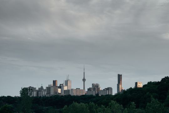
    But this concept of “overhousing” isn’t unique to California. The Globe and Mail just ran a piece talking about how Toronto’s designated “Neighborhoods” are losing people as the nests empty out, seniors remain put, and the broader city booms.

    The rate of depopulation that created the spare bedrooms in Toronto’s low-rise neighbourhoods is stark: “Since 2001, about 52 per cent of the land mass of Toronto has reduced in density of population by about 201,000 people,” Mr. Smetanin says. “Other parts of Toronto have grown by 492,000.”

    The irony of this phenomenon is that the city’s Official Plan considers these Neighborhoods to be “physically stable”, as well as “one of the keys to Toronto’s success.” However, things are clearly changing behind that physical stability.

    Photo by Verne Ho on Unsplash

  • Those wretched rear houses!

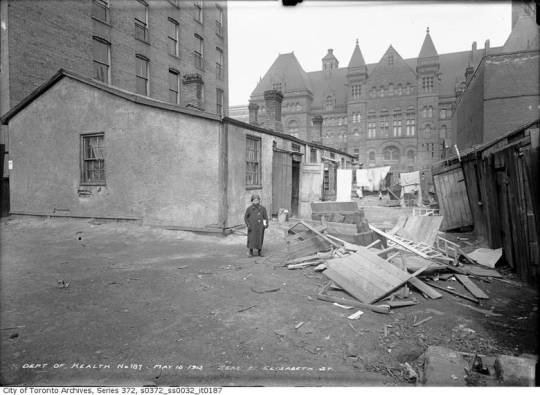
    Chris Bateman does some terrific sleuthing in the Globe and Mail this week to determine that the girl pictured in the below photo, dated May 15, 1913, is Dora (Dorothy) Cooperman – daughter of Morris Cooperman, a clothing presser.

    image

    Dora is standing in front of 3 wood-framed “rear houses” located behind 21 Elizabeth Street in an area known then as St. John’s Ward, or simply, The Ward. Behind her is City Hall, which we refer to today as Old City Hall. 

    If you’re familiar with Toronto, it shouldn’t take you long to figure out that she is standing in what is today the middle of Nathan Phillips Square in front of (new) City Hall. 

    The Ward no longer exists today, but as far as neighborhoods go its history is one of the most interesting. It was a high-density and mixed-use precinct that served as an important landing ground for successive waves of immigrants until it was deemed a slum and ultimately cleared. I wonder what it would look like today had it remained. Perhaps a bit like Kensington Market.

    It housed the Irish fleeing the Great Famine in the 19th century and was the center of Toronto’s Jewish community until the 1920s. The Cooperman family came from Kiev and identified as Jewish.

    There are so many interesting aspects to the above photograph. Everything from Dora’s pose to the juxtaposition between her surroundings and the grand (old) City Hall in the background. (Sidebar: I would like to try and recreate this same perspective. Would anyone like to model?)

    I also wonder why the city required a report to wake them up to the squalor that was living out in the Ward when they could have, presumably, just looked out their west facing windows.

    In 1911, Charles Hastings and Arthur Goss published what Batemen describes as a “landmark report that stunned civic officials, who had long ignored the poverty on their doorstep.” Hastings was the city’s medical officer of health, and Goss was the’s city first official photographer and author of Dora’s above portrait.

    One of the interesting things that Bateman explains about this report – and this is really the point of today’s post – is that it supposedly called out one particular housing typology as being highly problematic: rear houses. 

    These were houses that existed off the main street and could only be accessed via a laneway, like the one Dora is standing in. Today we would call them laneway houses. And so this report is evidence of over a century of anxiety around this particular housing type.

    It is obvious why overcrowding would have been deemed a serious problem at the start of the 20th century, but now one has to wonder how influential this report may have been in establishing the tone around these “rear houses.”

    Whatever the case may be, Dora’s story is an example of the role that this typology has played in housing people of modest means throughout this city’s history. It is also interesting, but perhaps not a coincidence, that affordability continues to be a part of the pitch around laneway housing and laneway suites. 

    Dora lived in a laneway house.

  • Canada’s 1%

    The Globe and Mail recently published an article about Canada’s highest paid workers. It uses census data spanning 2005 to 2015.

    There’s a feature that allows you to enter your before tax income, your location, and your gender to see how you compare to “the 1 percent.”

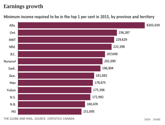
    But in case you don’t feel like doing that, here’s the minimum income required to be in the top 1 percent as of 2015 for each province/territory:

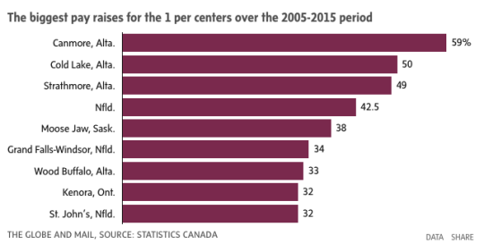
    And here are the communities where the 1% saw the biggest pay increases:

    The data certainly underscores how important commodities have been for growing individual incomes. Alberta, Newfoundland, and Saskatchewan are resource-rich provinces.

    However, the above data doesn’t capture the collapse of oil prices in 2014. So it would be important to also consider what this data looks like outside of a commodities boom.

    Charts: The Globe and Mail

  • How permissive zoning created Toronto’s King-Spadina district

    image

    Over the weekend, Marcus Gee of the Globe and Mail published a terrific article about Toronto’s King-Spadina district and how “condos conquered a rundown district of the city.” (This post will argue that condos were not the catalyst, but an outcome of other changes.)

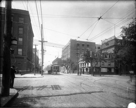
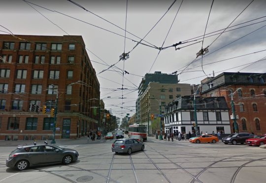
    The image at the top of this post (City of Toronto Archives) is the intersection of King Street and Spadina Avenue around the early 1900s. And here is roughly that same view from May 2016 (Google Streetview):
    image

    From this perspective, it may look like not much has changed. The buildings at the two corners are still there, although their uses have changed. The streetcars are still running, although we now have slightly newer machines. And there are overhead lines providing a canopy across the intersection.

    But as Gee points out, the reality is that in recent years King-Spadina has arguably seen more change and development than any other precinct in the city:

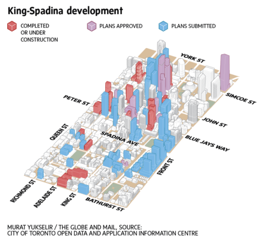
    No fewer than 99 projects have been built, approved or pitched since 2004. That’s one quarter of the total for the entire city and more than the count for two vast suburban districts – Scarborough and Etobicoke – combined. King-Spadina is overtaking even high-rise hubs such as Yonge and Eglinton in midtown Toronto and the Bay and Yonge corridors downtown.

    Below is a diagram showing the built form of that change.
    image

    But as we talk about this massive change, I would argue that this didn’t happen by accident. 

    Gee starts his piece by saying that “cities have an endless ability to evolve, to rebound, to reinvent and regenerate themselves, sometimes in ways that would astonish generations past.” I would add one word: Successful cities have an endless ability to evolve.

    King-Spadina has indeed reinvented itself many times. Prior to its current iteration, it served as a manufacturing district and as the center of Toronto’s garment industry. But from the 1970s through to the early 1990s, the area fell into decline as its manufacturing base left.

    The game changing moment happened in 1996 when “The Kings” – which includes the areas around both King-Spadina and King-Parliament – were redesignated as “Regeneration Areas.” The overarching goal was to deregulate away from single-use industrial zoning and allow the area’s buildings, both old and new, to take on almost any use.

    Now all of a sudden it was possible to have light industrial, commercial, entertainment, retail, residential, and live/work uses all mixed together. And with the bones already in place, the market responded. 

    In my view, it is these earlier changes that laid the groundwork for what has become one of the most exciting neighborhoods in the country.

    However, today some are worried about whether or not this is too much of a good thing. And I am sure that many would like to blame developers for piling up in this neighborhood. Why continue to build here when there’s lots of land elsewhere?

    King-Spadina is a perfect example of what Richard Florida would call “winner-take-all urbanism.” There are powerful clustering forces at play both globally and locally in our cities. And so there are real economic reasons for why King-Spadina has seen more development than Etobicoke and Scarborough combined.

    Permissive land use policies and the right building stock may have kickstarted things, but now economies of agglomeration have taken over. Retailers, restaurants, clubs, tech companies and people, among many others, are now fighting for space in this area for the same reason that Toronto’s garment industry once felt the need to cluster here. There are tangible benefits to doing so.

    What people are effectively asking today is at what point do we start to see diseconomies of agglomeration. This is an important question and one that needs to be actively managed. 

    Without getting into any of the details, I believe that the King Street Pilot Study – which puts transit first along the King corridor – is one very appropriate answer to this question. It is a direct response to diseconomies of agglomeration, in this case traffic congestion.

    But there are important corollaries to this question that are also worth considering: How do we now create more King-Spadinas and how do we create more broad-based and inclusive urbanism in the face of these powerful clustering forces? These are questions that go well beyond King-Spadina, but there are lessons to be learned from the successes seen on the west side of downtown Toronto.

    Images via The Globe and Mail and Google Street View

  • How did we miss this?

    I promise that this post won’t be all about laneways.

    This afternoon Erin Davis of Torontoist published a post called: Are Laneway Suites a Solution to Toronto’s Housing Crisis?

    There’s a quote in it from yours truly:

    Brandon Donnelly, a 34-year-old real estate developer, has submitted plans to the City to build a laneway home behind the house he owns in the St. Clair Avenue and Dufferin Street area. “Look, nobody is claiming that laneway housing is going to solve all of our affordable housing woes. But it will do two important things. One, it will unlock new ground-related housing, which is precisely the kind of housing that we’re no longer able to build at scale. And two, it will create additional rental housing,” says Donnelly.

    But I particularly like this one from Christopher Hume – urban affairs columnist at the Toronto Star:

    “But the City has all kinds of rules against it—‘You can’t do it for this reason, you can’t do it for that reason; oh no, we can’t have that!’ Why? Says who and for what reason?

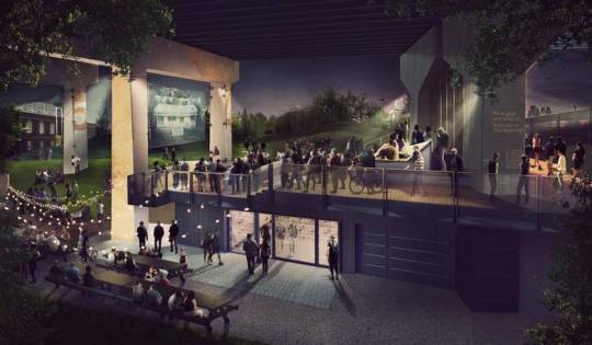
    This morning my friend Alex Bozikovic also published a piece on Toronto’s new 1.75km of public space under the Gardiner Expressway called The Bentway. It’s currently under construction and will open this winter.

    The timing of his article is actually quite serendipitous because I was in the area last night and as I walked past the construction site I couldn’t help but think to myself: “This is going to be absolutely brilliant once it’s done. Complete game changer for the area.”

    My point with these two examples is that in both cases we are rethinking – or at least trying to rethink – neglected urban spaces. It’s about finding value where no additional value was thought to be found. And I love that.

    Conventional wisdom has told us that our laneways and the spaces under our elevated Gardiner Expressway are not spaces to be celebrated. They are utilitarian at best and they are to be completely ignored at worst.

    But when The Bentway opens this winter I have no doubt in my mind that it will prove conventional wisdom entirely wrong. Who wants to hang out under an elevated highway? Watch the entire city. 

    One day I believe that we will also look back on our laneways just as we look back at the The Bentway before it became The Bentway. We will ask ourselves: How did we overlook this for so long?

    Image: PUBLIC WORK via the Globe and Mail

  • 5 decades of condo development in Toronto

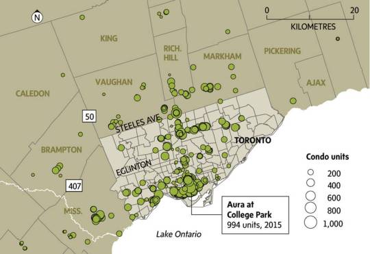
    Jeff Gray and John Sopinski just published a terrific set of maps in the Globe and Mail outlining 5 decades of condo growth in Toronto.

    Ontario first introduced the Condominium Act in 1968. The first condo project was supposedly built by Bert Winberg – founder of Rockport Group – between 1968-1969. He saw what developers were doing in California and Florida and he brought it to Toronto.

    Since then, here is what condo supply has looked like across the Greater Toronto Area:

    • 1970s – 11,697 units
    • 1980s – 30,881 units
    • 1990s – 49,503 units
    • 2000s – 103,683 units
    • 2010s – 109,497 units (up to September 2016)

    And here’s the map for the 2010s:

    We are now a condo city. For the full set of maps, click through here.

  • HOT, HOT HOUSES

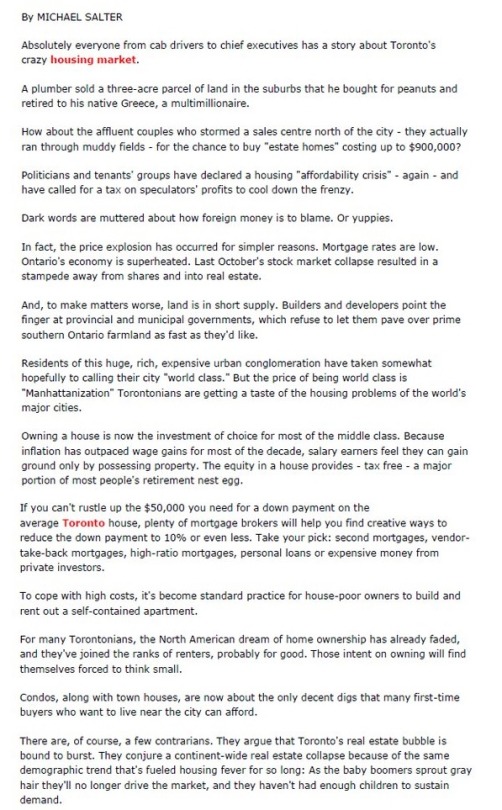
    Below is a piece by Michael Salter from the Globe and Mail. It’s all about Toronto’s HOT, HOT housing market. Michael’s message: Here are the real reasons why home prices are skyrocketing and why they are going to remain high.

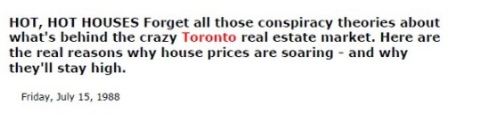
    Did you find yourself agreeing with this article or did you notice that something was off? If you noticed something, it may be because this article was originally published on Friday, July 15, 1988. And by that time, the North American dream of home ownership had already died in Toronto.

    Here’s the header I cut out from above:

    Thank you to Tamsin McMahon for tweeting this out last weekend.

  • An Honest Farewell

    image

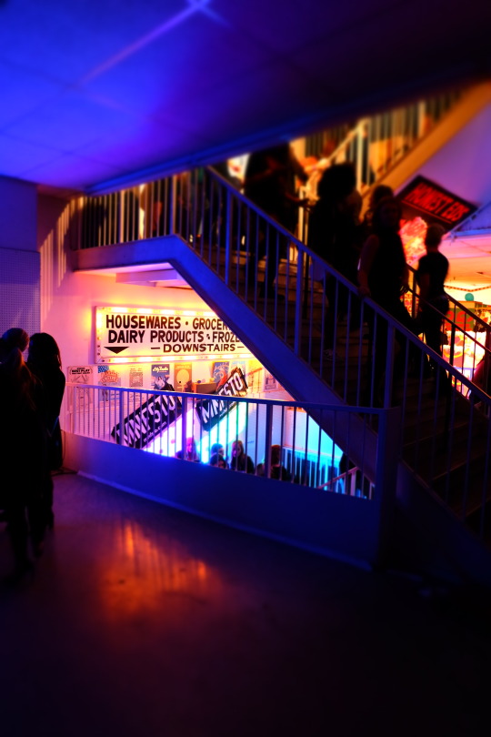
    I spent Saturday evening at Honest Ed’s for An Honest Farewell. It was a lot of fun. There were many familiar faces. And it felt very Toronto. See above photo.

    But part of me felt a bit phony pretending to celebrate the end of 68 years of operations. Truth be told, I’m not sure I ever bought anything from Honest Ed’s. Had it turned into a 3 floor super club sooner, perhaps I would have spent a bit more time there over the years.

    To me, Honest Ed’s was great big signage. 

    When I was a kid, my mom used to work on Bathurst Street just north of Bloor and I would go downtown with her early in the morning before school. It would still be dark out and I remember being so captivated by the bright lights of Honest Ed’s. That’s what the city meant to me. Lights. Flash. Excitement. It was where I wanted to be.

    A portion of the signage is being preserved and moved to Yonge and Dundas. But otherwise, this past weekend was the official end of an era. What matters now is the future of Mirvish Village. And the future is exciting.

    I’ll end with an excerpt from a recent Globe and Mail article by Alex Bozikovic:

    “The new development at Mirvish Village, after two years of conversation between developers Westbank, locals and the city, is inching closer to approval, with a new proposal submitted in January to the city. Westbank paid $72-million for the site, a big number, and yet the result is as good as private development gets in Toronto. It features meaningful preservation of heritage buildings, a serious sustainability agenda, and affordable housing – not to mention an architectural and leasing strategy geared at making the place as lively as possible, even a bit weird.”

  • Province rejects Toronto’s proposed road toll plan

    Earlier this week I was in an Uber heading up to Charles Street and the driver made a comment to me. He said that since he moved to Toronto in the 90′s, traffic has gotten progressively worse every single year. He continued on to say: and yet we continue to build, build, build.

    My response won’t surprise anyone who reads this blog. I said that Toronto has become a far more exciting city since the 90′s because of intensification (though 1992 and 1993 were pretty awesome) and that the problem is our mental model. We haven’t moved beyond the car as the perceived solution to urban mobility.

    A perfect example of this is what just happened with the province vetoing Toronto’s proposed road toll plan. 

    Firstly, I fully agree with Marcus Gee of the Globe and Mail that this is both an act of cowardice (the province gave every indication that they initially supported the plan) and an act of arrogance (we are talking about roads owned by the city, not the province).

    I also find it incredibly frustrating that Toronto cannot control its own destiny. This is a mistake and it needs to change if we – and the rest of the cities in this great country – are to continue competing at a high level in this urban century.

    But to my initial point, the problem with this move is that it signals a status quo mental model. It is a clear reluctance to make any sort of bold moves to move Toronto in a new direction. I guess we are happy with the current trend line. More traffic.

    We shouldn’t be.