Daily insights for city builders, delivered every morning at 6 AM ET. I’m Brandon Donnelly — a Toronto-based real estate developer and founder of Globizen. I’ve been writing here since 2013.

Tag: global cities

  • Toronto jumps 9 spots in Kearney’s 2020 Global Cities Outlook ranking

    “…the pandemic and its aftermath have also created a rare openness to doing things differently. Seizing this opportunity won’t be easy, or a short-term affair. But if we can be certain of anything, it’s that cities will adapt and evolve, and that they have the potential to come back stronger.”

    – Kearney 2020 Global Cities Report

    The Kearney 2020 Global Cities Report is out and it incorporates two main rankings: their Global Cities Index (GCI) and their Global Cities Outlook (GCO).

    The former is intended to be a snapshot of where things stand today and the latter is intended to be a forecast of where things might be heading.

    Here’s their GCI:

    And here’s their GCO:

    Note: The big mover in their GCO is Toronto, jumping nine spots to take second place behind London.

    The full report can be downloaded over here.

  • The paneláks of Prague

    At the beginning of this year (which seems like eons ago), I wrote about a CityLab series that Feargus O’Sullivan was doing on the vernacular home designs of a handful of European cities. Cities like London and Berlin.

    Well, after a brief pause, that series is back in the form of a CityLab “storythread.” It’s now called, “The Iconic Home Designs That Define Our Global Cities.” In it, he explores the various floor plans, housing typologies, and tenures that you might find around the world. Everywhere from from Singapore to Reykjavik.

    The most recent article is all about Prague’s communist-era apartments. Apparently people call these paneláks because they were initially built using some sort of collection of prefabricated panels. They were a quick and dirty housing solution for a city and country that were rapidly urbanizing starting in the late 1950s. (See, prefab works.)

    But what I find most interesting about the story of these paneláks is how their reputation seems to have changed and evolved over time. They proved to be a far more adaptable form of housing than you might initially think, going from written off and ready for demolition, in some cases, to then becoming a form of aspirational housing.

    Part of this allegedly had to do with a handover from state ownership to private ownership, which maybe goes to show you that architecture and design, alone, aren’t enough when it comes to housing innovation. You really need to consider the whole picture.

    But regardless, it is clear to me that tastes do change, and housing is no exception. Renewal is an integral part of urban life. And one generation’s trash might be another generation’s treasure.

    Photo by Jakub Matyáš on Unsplash

  • The many forces shaping our cities

    Richard Florida has a three-part essay over on Bloomberg CityLab about the forces that are currently shaping American cities. In part three, he argues that this pandemic will likely accelerate many of the trends that were already underway — families will continue to like the suburbs and young people and businesses will continue to cluster in dominant global cities. At the same time, he argues that we will see a kind of “urban reset.” A window of opportunity where we just might be able to rebuild our cities to be more affordable, more inclusive, and more productive. Could this be the moment where we commit to transforming our suburbs into more walkable mixed-use communities? Could this crisis actually strengthen our cities, as I have argued before on the blog? At this point in time, the only thing I really know for sure is that most of our predictions will be wrong.

  • A comparative analysis of global cities

    Since 2005, LSE Cities (London School of Economics) has been collecting comparative data on how global cities perform in terms of key spatial, socioeconomic, and environmental indicators.

    This is their latest data matrix:

    To be clear, it is not a ranking of cities. It is intended to help us better understand how different cities around the world are performing.

    Depending on how you’re consuming this post, the text may be difficult to read. So here’s what each column represents, moving from left to right:

    • Current population in the administrative city (millions)
    • Current population in the urban agglomeration (millions)
    • Average hourly population growth of urban agglomeration 2015 to 2030 (people per hour)
    • Administrative city area (km2)
    • Average density of built-up administrative area (people/km2)
    • GDP per capita in urban area ($, PPP)
    • Percentage of country’s GDP produced by the metro region
    • Population under 20 (%)
    • Murder rate (homicides per 100,000 inhabitants)
    • Percentage of daily trips made by public transport
    • Percentage of daily trips made by walking & cycling
    • Car ownership rate (per 1,000 inhabitants)
    • CO2 emissions (tonnes per capita)

    If you’d prefer to download a full PDF of the chart, click here.

  • The coldest and hottest global cities

    Below is a list of the 44 cities found in the 2018 Global Power City Index by the Mori Memorial Foundation’s Institute for Urban Strategies.

    The index ranks the major cities of the world according to their “magnetism”, which they generally define as a city’s ability to attract people, capital, and businesses from around the world.

    As with all rankings, the output depends entirely on the methodology that you use. The GPCI seems to have the right executive committee in place. It includes global city authorities like Saskia Sassen. But that’s not really the point of today’s post.

    Beside each city, I have added the average highs and lows (in celsius) for both the coldest and hottest months of the year. For cities in the northern hemisphere, these are typically January and July/August, respectively.

    I have also added the spread between the hottest and coldest months to get a sense of variability. I always find it interesting to see how cities like Singapore, Kuala Lumpur, Jakarta, and Mumbai basically stay the same temperature all year round.

    When you look at this list, remember that you can ski in Dubai.

    All weather data taken from the NOAA (National Oceanic and Atmospheric Administration).

  • How large metro areas are driving the global economy

    “The concentration of economic growth and prosperity in large metro areas defines the modern global economy, creating both opportunities and challenges in an era in which national political, economic, and societal trends are increasingly influenced by subnational dynamics.” -Brookings Institute

    The Metropolitan Policy Program at the Brookings Institute has a new report out for 2018 called the Global Metro Monitor.

    Here are some of the highlights (data is from 2014 to 2016):

    – The 300 largest metro areas in the world accounted for 36% of employment growth and 67% of GDP growth.

    – Metro areas in China and the Asia-Pacific region outperformed, whereas Latin American cities, and in particular the largest Brazilian cities, were weaker performers.

    – The majority of large metro areas had growth rates that exceeded that of their respective regions. So again, cities are the driver.

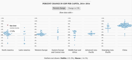
    And here is an interesting interactive chart (better to click through) that shows the % change in GDP per capita. 

    image

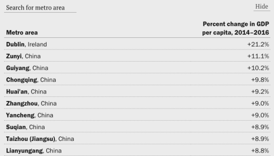
    Look at how much of an outlier San Jose is. Though, check out Dublin in the footnote. And if you look at the actual data table, it is all China, except for Dublin at the top.

    image

    For the rest of the charts, click here. And to download the full Global Metro Monitor report, click here.

  • Toronto: 2000 vs. 2025

    Last week, Joe Berridge, Partner at Urban Strategies, gave a presentation at the Institute on Municipal Finance & Governance titled, Toronto: The Accidental Metropolis. I’ve seen Joe give similar presentations to this one before, and I always thoroughly enjoy his focus on Toronto’s position as a global city.

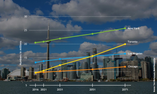
    Here is a slide from the presentation that projects out Toronto’s population to 2071 and compares it to the largest cities in the US.

    image

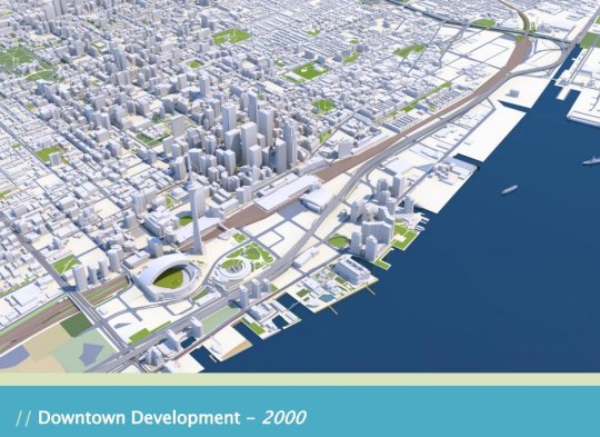
    But the two slides that have been really making the rounds online are the following ones. The first is a rendering of what downtown Toronto looked like in 2000. 

    image

    I remember this time clearly. Queen West seemed to end at Spadina. King West and Ossington weren’t things. And “Richmond and Adelaide” felt like the greatest club district in the world. (If you’re not from Toronto, these references will likely mean nothing to you. Sorry.)

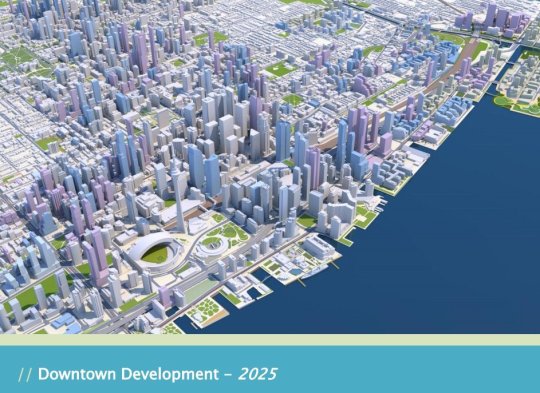
    The second slide is a rendering of what Toronto will look like in 2025. The transformation is just incredible.

    image

    I’ve seen some people comment that the Toronto of 2000 was relatively affordable; the Toronto of 2018 is unaffordable; and the Toronto of 2025 will be even more unaffordable with all of this new development.

    But I don’t understand that logic. Considering the growth rate shown in the first slide, imagine how unaffordable this city would be if we weren’t building new places for people to live and new places for people to work.

    For the full slide deck, go here. And for recent aerial photos of Toronto’s downtown core, check out my Instagram page.

  • New School of Cities

    The University of Toronto just announced a new School of Cities. It will begin operations on July 1 of this year (2018) and bring together researchers from various disciplines to address the world’s most critical urban challenges. 

    Insert stat here about the percentage of the population that will live in an urban area by 2050.

    There are more than 220 faculty members across 40 different academic divisions at the University of Toronto who are doing urban-focused work. The School of Cities is intended to bring those minds together.

    So far there are plans for a “global cities summit” and an “urban lab” that will also bring students, faculty, industry, and government together. The intent is for the School to act as a city builder both locally (Greater Toronto Area) and globally.

    This once again goes to show just how important we are all taking urban issues today. But I am sure this blog audience didn’t need to be reminded of that.

    If you would like to sign up for updates from the School of Cities, you can do that here.

    Photo by Jorge Vasconez on Unsplash

  • The City as a Place for People

    The City of London Corporation recently published a report called “The City as a Place for People”, which talks primarily about itself and how great London is as a magnet for talent. 

    But as self-serving as it may be – the report is timed to be ahead of this year’s MIPIM – there appears to be some data and interviews backing up the claims.

    58% of “institutional investors” said that London is the best European city for business. Dublin was next at 22%. 

    A separate survey of 2,568 “corporate decision makers” in Europe revealed that 21% of respondents felt that London was the best European city for business, followed by Paris (13%) and Frankfurt (7%). When asked which city had the best talent pool, the responses were fairly similar.

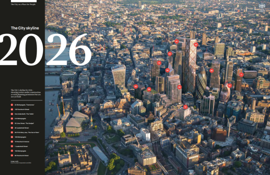
    Also included in the report is a rendering of the City’s skyline by 2026. These are always fun to see. Here is a screen grab:

    image

    It is showing all towers under construction and all towers with their planning permissions in place. If you’d like to download the full report, you can do that here.

  • How should mid-sized cities really compete?

    Jennifer Keesmaat – the former chief planner of Toronto – recently published an article in Maclean’s called: Toronto’s unaffordable. Why can’t Halifax or Saskatoon take advantage? Her argument: 

    “The hard truth is that many mid-sized cities won’t win the future because they are stuck on a suburban growth model. If the future is green and walkable, they will be left behind.”

    The model city that is held up is Portland – a terrific mid-sized city of only 640,000 people that has used progressive land use policies to build a livable and dense urban center. (In all fairness, the Portland MSA has over 2.4 million people.)

    Now, if you’re a regular reader of this blog you’ll know that I have a penchant for dense urban centers. I live and I work downtown. And I would happily trade square footage for a more sensible commute and lower transportation costs.

    But after I read the article, I couldn’t help but think that progressive land use policies, alone, aren’t enough. Cities, like social networks, experience network effects. That’s why there’s so much talk these days of winner-take-all urbanism.

    All of this is not to say that progressive urban policies are a bad thing. Quite the opposite. I just think there are many other factors at play if we’re talking about taming the hegemony of our global cities.