Daily insights for city builders, delivered every morning at 6 AM ET. I’m Brandon Donnelly — a Toronto-based real estate developer and founder of Globizen. I’ve been writing here since 2013.

Tag: florida

  • Building on stilts

    image

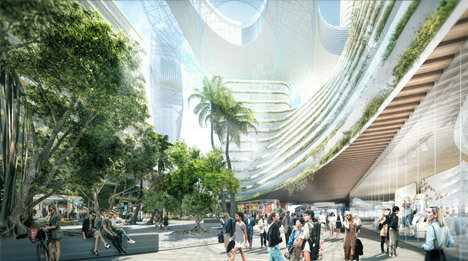
    Last week Bjarke Ingels Group and UIA Management announced a 125,000 square meter mixed-use complex in Allapattah, Miami called the Miami Produce Center. 

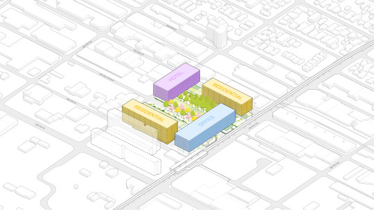
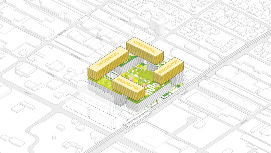
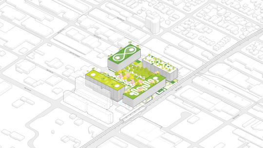
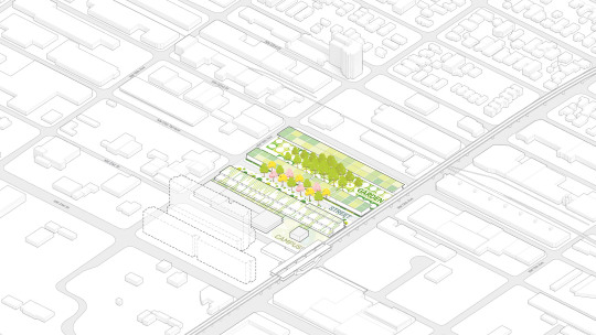
    The proposed project includes office, residential, and hotel uses on stilts over three existing warehouse buildings. The existing buildings will be transformed into restaurants, shops, cafes, and a school. And supposedly, at least according to the renderings, the parking garage will be designed so that it can be transformed into a club at a night. This is Miami after all.

    Here are a few diagrams from BIG showing the build up:
    imageimageimageimage

    Perhaps best known for its warehouses and Dominican population, investors have been speculating for years that Allapattah would eventually become the next Wynwood. Here’s some evidence that it already has the requisite bars and artsy things.

    Does this project signify a tipping point for the area? Feels like it. But those of you who know Miami better than I do would be in a better position to comment.

    Images via Dezeen
  • A picture of dynamic road pricing

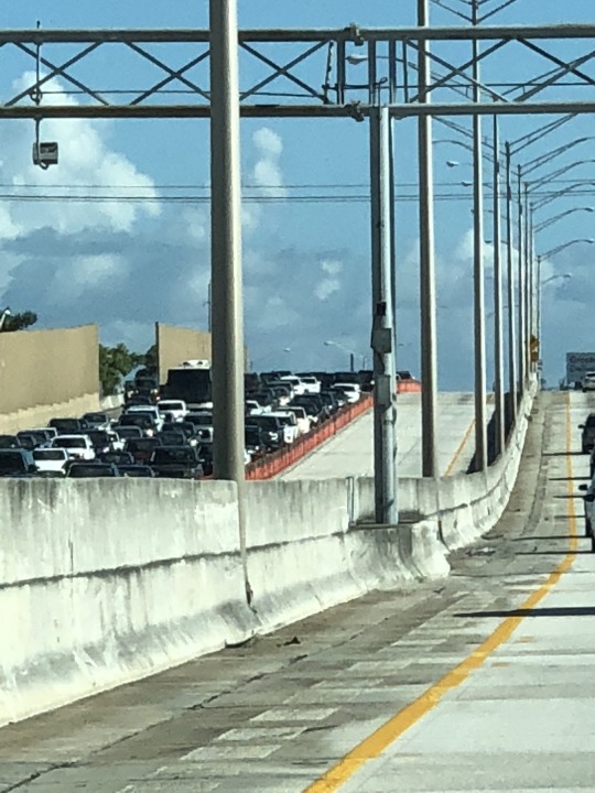
    Below is a photo of Interstate 95 near Miami, which, for the record, I myself did not take while driving.

    image

    The two empty lanes that you see are the “Express Lanes.” The price for using these lanes varies based on demand.

    During periods of low demand, the toll could be around $0.20 per mile. 

    During periods of high demand, such as during rush hour, it might be $1 per mile. 

    And during unusually heavy periods, like when there’s an accident, it could be more.

    We used these lanes while driving around the Miami area on this trip. The pricing always seemed reasonable and the lanes were never congested.

    I think the above picture is a good demonstration of how dynamic road pricing can be used alleviate traffic congestion.

    That’s why many cities, such as Portland, are exploring it as a solution. I wish Toronto would do the same.

  • Before & After — Miami Beach

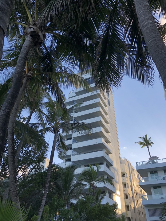
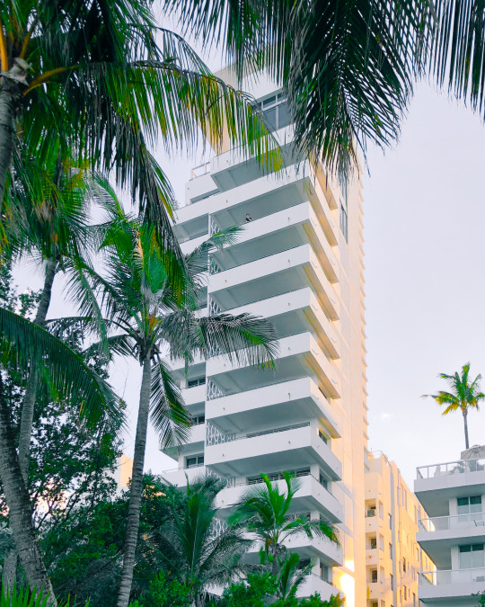
    We switched coasts today. Here is a photo of our Miami Beach hotel taken from the boardwalk with my iPhone:

    image

    And here is the after:

    image

    I took it into Lightroom. Fixed the alignment of the building. Whitened it, but brought out the beautiful warm sunset light on the north elevation. And I took the greenery in the foreground out of the shadows.

    The balconies remind me of one of Donald Judd’s “Untitled” pieces. He was one of my favorite artists. I also like the one dude leaning over that upper balcony. It gives the photo a tranquil feel, which is not usually how one would describe Miami Beach.

  • Red tide, scooters, and civic security

    image

    I am reading up on a few different things this morning.

    Southwest Florida, which is where I am right now, is in the midst of a “red tide” that began last November. These happen fairly regularly along the Gulf Coast, but this one is high up on the severity scale. There doesn’t appear to be a clear explanation for what causes them, but sustained warmer temperatures and fertilizer and other pollutant runoff are thought to stoke it. Whatever the cause, they are devastating to the environment. We are switching coasts tomorrow morning.

    Portland now has electric scooters. (Why don’t we have these in Toronto?) But to combat possible concerns around urban clutter, the company, Bird, has committed to collecting all of its scooters each night and has agreed to remit $1 per scooter per day to the city. These scooters are pissing off some cities (or maybe it’s just San Francisco), but I still believe the problem will eventually get resolved. City Observatory also has this interesting piece where it compares the above scooter pricing to car pricing. Are we underpricing cars?

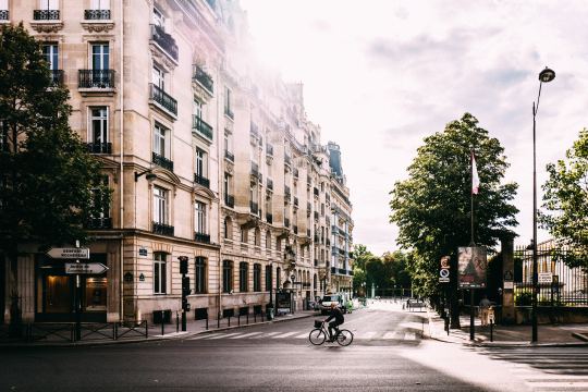
    Finally, here is a short film on civic security in Paris. In an effort to mitigate terrorism, the city has, of course, been implementing and erecting fencing, barricades and other reactive security measures. But sadly, now that this has become a new reality, the capital is spending more time considering how these measures could be more thoughtfully designed. The video showcases some of them. Certainly a more deliberate approach, but are they just as reactive?

    Maybe one of these topics will be of interest to you too.

    Photo by Andreas Selter on Unsplash

  • Melting lollipops

    I’m out of office for the next week and so I’m going to try a bit of photoblogging. Here is a photo that I took this afternoon at Elena Bulatova Fine Art Gallery on St. Armand’s Circle. I really liked the art, and especially the melting lollipops and popsicles. They certainly felt climate appropriate.

  • Puerto Rican migration during and following Maria

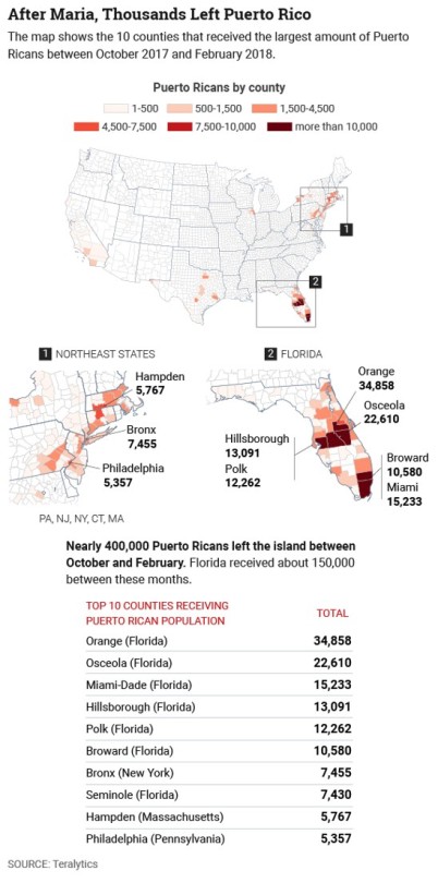
    Teralytics recently looked at data from 500,000 smartphone users to determine how, when, and where Puerto Ricans moved between August 2017 and February 2018 during and following Hurricane Maria – generally considered to be the worst natural disaster on record for the area. 

    CityLab published the data here and along with the following maps:

    image

    It shows the locations and the top 10 counties that received Puerto Rican population during the above time period. Florida and the Northeast are at the top of list, which isn’t all that surprising. Privacy concerns aside, it is once again an example of the kind of granular data that we now have access to. Prior to this data being available, all we apparently had was estimates.

  • Going down east

    I live in Toronto. 

    When I am headed north to cottage country, I say that I am going up north.

    When the Florida snowbirds talk about escaping the winter, they usually say that they are headed down south.

    These geographic references are fairly straightforward.

    If a friend were to move to Vancouver, I might say that she or he moved out west. This one starts to get a bit more interesting because it speaks to a location that is out, or away, from the center. Toronto is the center and that person has moved out from it.

    But the one that really made me think was down east. My mother was born in the Canadian Maritimes and when she references this part of the country she calls it down east. 

    I used to ask her: “Why is it called down east? Geographically, it is actually up east.”

    Turns out that down east is (probably) a nautical reference. It is used to identify parts of the east coast in both New England and Canada. The prevailing winds in these parts blow from the southwest. So when sailors traveled from the west to east they were going downwind.

    So there you have it. Do you have any peculiar geographic references in your part of the world?

    UPDATE: I should have also mentioned that the St. Lawrence River generally flows north-easterly and that there’s an elevational difference between what was formerly known as Upper Canada and Lower Canada.

    Photo by Matthias Jordan on Unsplash

  • Flood-prone areas see dip in real estate sales

    image

    The New York Times has an interesting article up talking about the possible impacts of climate change on coastal real estate in the United States. In it they make the argument that sales velocity is declining in flood-prone areas. Here are two snippets:

    Over the past five years, home sales in flood-prone areas grew about 25 percent less quickly than in counties that do not typically flood, according to county-by-county data from Attom Data Solutions, the parent company of RealtyTrac. Many coastal residents are rethinking their investments and heading for safer ground.

    In the past year, home sales have increased 2.6 percent nationally, but have dropped about 7.6 percent in high-risk flood zones in Miami-Dade County, according to housing data. Many coastal cities are taking steps toward mitigation, digging runoff tunnels, elevating roads and building detention ponds.

    I would like to see more data supporting this argument, but I can’t say I’m surprised. Flood risk is certainly something I would think about – particularly in high-risk areas such as South Florida. Florida has 6 of the 10 most vulnerable urban centers in the US.

    The other piece that caught my attention is this:

    Flood risks are easily overlooked because past flood damage often goes unreported and, as in Virginia, the burden of discovering it falls to the buyer. LexisNexis, a news and legal research company, can supply sellers a report with the history of flood claims on the property, but buyers usually do not know to ask for it. FEMA collects information on federal insurance claims for homes nationally, but the agency has been reluctant to make it public for privacy reasons.

    It is yet another example of how opaque the real estate industry is. A lot of the information – assuming it’s even available – is fragmented across a number of different sources. If you’re playing hot potato, this obviously works to your benefit. But I don’t believe it’s the best thing for the overall market.

  • Fabricating a new urbanism

    image

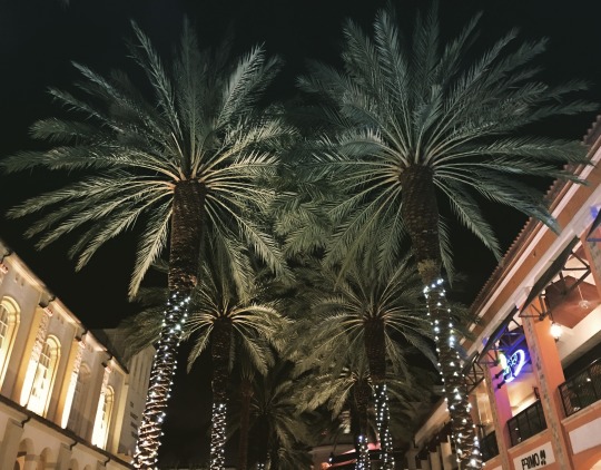
    Last night I was in CityPlace, West Palm Beach. Completed in 2000, CityPlace is a quintessential example of New Urbanism. (For those of you from Toronto, this is a different kind of a CityPlace.)

    In case you’re unfamiliar with this movement, here’s a snippet from The Charter of New Urbanism (via Wikipedia):

    “We advocate the restructuring of public policy and development practices to support the following principles: neighborhoods should be diverse in use and population; communities should be designed for the pedestrian and transit as well as the car; cities and towns should be shaped by physically defined and universally accessible public spaces and community institutions; urban places should be framed by architecture and landscape design that celebrate local history, climate, ecology, and building practice.”

    At a high level, New Urbanism makes a lot of sense. American cities were sprawling uncontrollably and so advocates had decided that something had to change. The Congress for New Urbanism was founded in 1993.

    But the New Urbanism movement has had its share of critics. Here’s how Witold Rybczynski – professor at the University of Pennsylvania – talked about it on his blog:

    “What are the important ideas that have affected American cities in the last 20 years? The development of waterfronts. The renaissance in constructing urban parks. The move of genXers and retirees into downtowns. High-rise urban living and Vancouverism. The popularity of urban bicycling and bike-rental programs. Ditto for Zipcars. Urban farmers markets and community gardens. Urban charter schools. The dramatic expansion in attendance of urban cultural institutions, especially art museums. Urban tourism. Downtown trophy buildings. The emergence of influential big-city mayors. Have any of these been the result of the new urbanism movement?”

    Frankly, I have never been a big follower of New Urbanism. It has always felt artificial to me. But I recognize the immense challenge in transforming car-oriented cities and communities into walkable ones. It’s one of the greatest challenges in city building. You’re asking people to change their habits.

    If any of you are experts on New Urbanism (because I am certainly not), I would love to hear from you in the comment section below.

  • Are there enough nerds in Miami?

    image

    I was browsing through my online reading list this morning (as I do every morning), and I stumbled upon this Dezeen article talking about a big new 6.5 million square foot development being proposed in Miami’s Park West neighborhood. 

    The goal of the project is to transform Miami into “Florida’s Silicon Valley.”

    This sort of thing is happening all around the world. From Buffalo to Lisbon, cities everywhere are betting on tech, startups, and entrepreneurship to grow their economy in the 21st century. And I personally think that’s really exciting.

    But as I was reading the article, I couldn’t help but think of an old essay that Paul Graham wrote back in 2006 called, How to be Silicon Valley. (Paul Graham is a famous Silicon Valley entrepreneur/investor).

    In his essay Graham argues that to be or to replicate the model of Silicon Valley in your city, you basically need two types of people: rich people and nerds. The idea, of course, being that the nerds work on the cool new ideas and the rich people then fund them.

    Using this logic, he specifically calls out Miami as a city where few startups happen and as a city not likely to become another Silicon Valley. Though there’s lots of money and rich people in Miami, there simply aren’t enough nerds. In Graham’s words: “It’s not the kind of place nerds like.”

    But that was back in 2006. 

    The iPhone didn’t even exist yet. Things have since changed. Now there are successful tech companies like Snapchat (valuation north of $15 billion) that are based out of cities like Los Angeles. And I think you could argue that Los Angeles and Miami do share some similarities.

    So while it may have seemed far fetched in 2006 for Miami to become a startup hub, is that really the case today?

    Image: Dezeen