Daily insights for city builders, delivered every morning at 6 AM ET. I’m Brandon Donnelly — a Toronto-based real estate developer and founder of Globizen. I’ve been writing here since 2013.

Tag: downtown

  • Sorry, you can’t build that kind of housing here — downtown or the distant suburbs

    Between 2016 and 2021, and according to this recent report from Statistics Canada, the population of the Toronto CMA (Census Metropolitan Area) grew by over 274k people:

    The population of the Montréal CMA grew by nearly 188k people:

    And the population of the Vancouver CMA grew by over 179k people:

    These are the three largest CMAs in the country and they, not surprisingly, also have the three largest “downtowns.” As of the spring of 2021, the most populated downtowns were as follows: Toronto (275,931 people), Vancouver (121,932 people), Montréal (109,509), Ottawa (67,169 people), and Edmonton (55,387).

    In this exercise, Statistics Canada breaks down each CMA into 5 categories, which are generally based on two things: (1) your typical monocentric city model (downtown in the middle with a declining gradient of surrounding sprawl) and (2) how long it takes to commute — by car during non-rush hours — from downtown to the surrounding areas.

    The good news in all of this is that Canada’s downtowns seem to be doing just fine. Broadly speaking, they are growing at a faster rate than their respective CMAs and growing at 2x the rate of the previous census cycle. Halifax’s downtown grew at 26.1% from 2016 to 2021 and Calgary grew at 21%, to give two more examples. So I think you can safely ignore what you may have heard about a pandemic exodus. Those people are now returning from the country after realizing that there aren’t any pretentious coffee shops and expensive butcher shops.

    But something else is also going on in Canada’s largest urban centers. The concurrent trend is continued urban sprawl. The biggest downtowns are growing quickly, but so are the distant suburbs (30 minutes or more from downtown). And they are growing at a faster rate than everything in between. This is not entirely surprising, but it is obviously concerning from a climate change perspective and because it suggests that people are being forced to do the old “drive until you qualify” thing.

    These two phenomena are the most pronounced in the Toronto CMA. If you scroll back up to the top of this post, you’ll see that downtown absorbed a decent chunk of the population growth (about 14%), particularly considering its small footprint. But then if you look at the distant suburbs (the mustard color), you’ll see that it’s where 72% of new entrants went!

    The question I like to ask with all of this is, “are people choosing to move to the distant suburbs because that’s the housing and location that they truly want, or are people choosing it because it’s all they can afford?” There is an argument out there that sprawl is a natural market outcome and that we shouldn’t be forcing people to live in higher-density housing. And I am certainly sympathetic to giving people as much choice as possible.

    But how much choice are we really giving people in our biggest cities? We have figured out how to intensify our downtowns through mid- and high-rise development. And evidenced by the growth rates, many people are enjoying this form of housing and the kind of urban lifestyle that comes along with it. But if it happens to not work for you, our current solution is, “either be rich so you can remain close to downtown or go for a drive.”

    What is clear from this latest census data is that we haven’t yet figured out the in-between. The missing middle is still missing. And that’s because we have clear mechanisms in place to more or less ensure this is the case: (1) We restrict meaningful growth from taking place in our single-family neighbourhoods and (2) we have made a habit out of shifting some of the incumbent tax burden to new entrants through things like development charges.

    Overall, it’s a devilishly clever system where two things happen: “Sorry, you can’t build that kind of housing here. Build it somewhere else. By the way, I’d like to keep my property taxes as low as possible, so not only do I not what you close to me, but I’d also like you to help pay for some things. Cool?” This is the arrangement that we are seeing playing out in these charts. It can be easy to ignore, but it’s there.

    Charts: Statistics Canada

  • US downtowns by use and square footage

    This is an interesting chart from the New York Times showing the breakdown of (real estate) uses across the largest downtowns/CBDs in the US. It was put together using satellite data and data from CoStar, including their boundary definitions for each downtown/CBD. The point of the chart is to show that some US downtowns are heavily dominated by office square footage. But if you look a bit closer, there are other interesting takeaways. Look at retail in Honolulu, hotels in Austin, and how much residential many US cities have in their CBDs.

  • A walking tour of Vancouver House

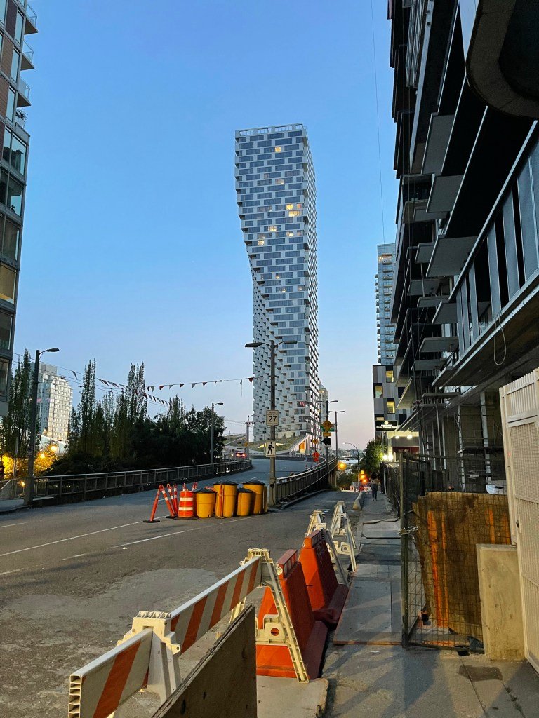
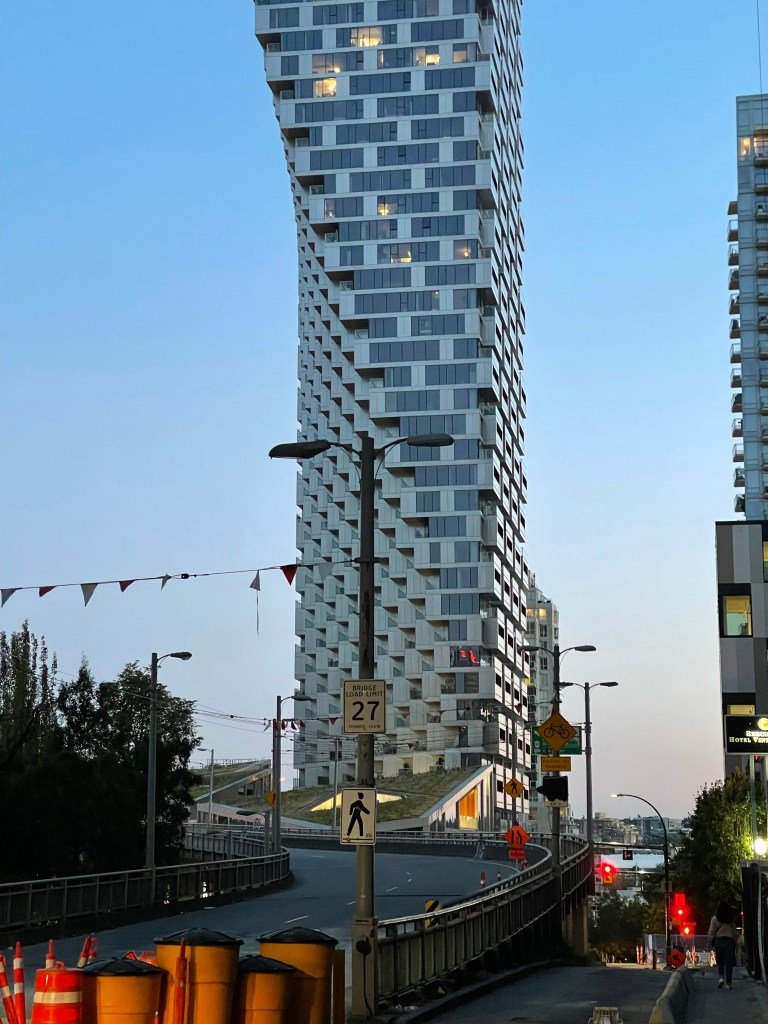
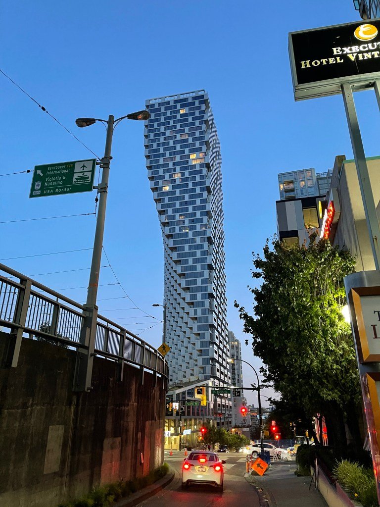
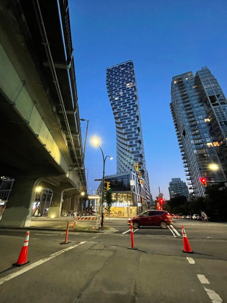
    Vancouver House is such a wonderful example of great city building. It’s an awkward site hugging the off ramps of the Granville Street bridge. It’s less than ideal.

    And yet Westbank (developer) and Bjarke Ingels Group (architect) have turned it into something remarkable. The tower is incredibly unique, though it is not form for the sake of form. It is a direct result of the site’s setback constraints.

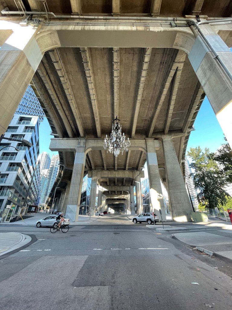
    But perhaps more importantly, the project manages to activate the ground plane and underneath the off ramps through its architecture, a mix of uses (retail and office) and a giant chandelier.

    So if you happen to find yourself in Vancouver, I would encourage you to visit the Beach District and do a walking tour of Vancouver House.

    There’s also a great Italian restaurant in the base of the tower (Autostrada Osteria) that you should try once you’ve finished your tour.

  • yongeTOmorrow

    Yonge Street divides Toronto between east and west. It’s an iconic street (though it has its ups and downs). Since 2018, the City has been studying ways to redesign and improve the stretch that cuts through the middle of downtown.

    It is a story that we have seen in many other cities around the world, perhaps most famously in NYC. Here is a street where pedestrians outnumber vehicles and yet we allocate more space to the latter (within a fixed ROW). This study hopes to fix that.

    They’ve narrowed things down to four Alternative Designs (downloadable, here). All of them prioritize pedestrians, but in different ways. As of right now the preferred option is Alternative #4. It looks like this:

    The section around Dundas Square (from Dundas Sq up to Edward Street) is fully pedestrianized with only emergency vehicles having access during the day. This segment has the highest pedestrian volumes. The other blocks allow for a combination of one-way and two-way vehicular traffic.

    Vehicular access is obviously still important for things like loading, but it’s pretty clear that the future of Yonge Street is pedestrian priority. We should probably be doing this right now. If you’d like to voice your own opinion, you can do that here until Friday, December 6, 2019.

  • Urban metabolism

    I spent this morning in the suburbs bouncing around to a few different meetings. I then came back downtown so that I could get some actual work done in the office. And then after that, I was around downtown getting a bunch of different things done.

    I am mentioning this to you all because today I was reminded of how different the metabolic rate can feel in the city compared to the suburbs. There are even studies suggesting that people walk faster in larger cities.

    Some businesses, of course, require a lot of space and the economics simply do not work in the core of the city. We all get that. But if you’re competitive advantage is human capital, then this is something to think about.

    I feel like I spent most of my morning driving around, which I’m not complaining about, except that I could have probably had 3x as many meetings in the city during that same period of time. If you multiply that out over time, then we’re talking about a material spread in overall productivity.

    And we haven’t even touched on those fortuitous urban encounters, which do happen and do provide all sorts of benefits. As much as we’re all connected like never before – through things like, well, this blog – there’s nothing like shaking somebody’s hand and looking them in the eyes.

  • Photography heli tour

    Tonight I went a photography heli tour with @normandthegang

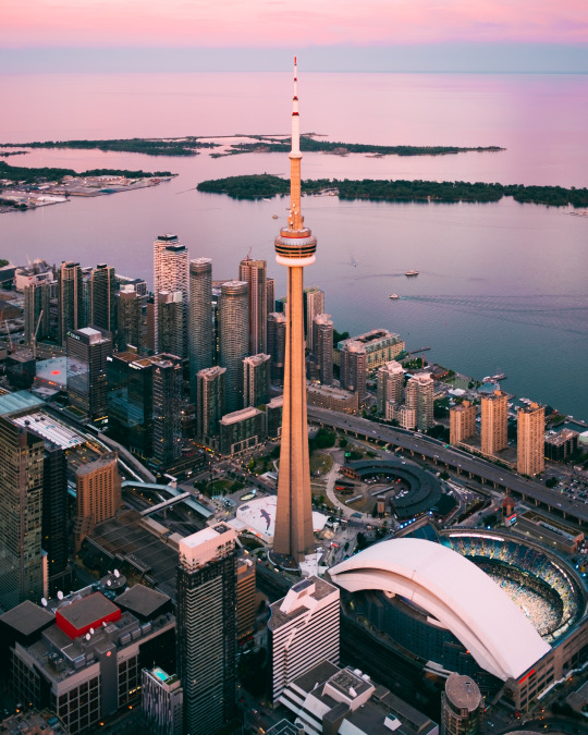
    I took almost 500 photos, including a bunch of aerials of our development sites. And we got lucky with a pretty spectacular pink sunset. 

    Here is a photo that I took of the CN Tower with my Fuji X Series (35mm prime lens):

    Lake Ontario actually looked like that. This is not post-production chicanery. Follow me on Instagram to see the rest of the photo series.

    Thanks again for the invite Norm. That was a lot of fun. 

  • We’re hosting a pre-design community meeting in Hamilton

    This fall Slate acquired a retail center in Hamilton called Corktown Plaza. It is the block bounded by John Street South, Young Street, Catharine Street South, and Forest Avenue. It is just south of the Hamilton GO Centre in downtown.

    It is currently a much used single storey retail plaza with a large surface parking lot facing John Street South. It’s still early days, but the long-term plan is to redevelop it into a mixed-use retail and residential complex.

    Before putting pen to paper, the team is hosting a “pre-design community meeting” this Tuesday, December 12, 2017 at 7pm at the Church of Ascension down the street. Address is 64 Forest Avenue (accessible entrance at 258 John Street South).

    Here is the invite (embedded tweet):

    https://platform.twitter.com/widgets.js

    The purpose of the meeting is to gather feedback from the community before beginning design. We want to know what’s working today, what’s not working today, and what would be ideal for the future. 

    CORE Architects and GSP Group (planning) will be in attendance along with the Slate team. The format will be brief presentations followed by interactive breakout sessions. There will be trace paper on hand so that we can all put pen to paper.

    If you live and/or work in the area or are simply interested in the future of Hamilton, please feel free to join us on Tuesday evening. If you can, send a quick email to rsvp@kga-inc.com letting us know you’ll be coming. But just showing up is also perfectly fine.

  • Corporate disaggregation (and some book suggestions)

    The truism is that both people and companies are moving back to downtowns. We are living in an urban era. But when you really look at the data, it is clear that the suburbs are far from dead. And when it comes to companies, the way in which they are relocating to downtown is not the same as it was in previous generations.

    The Economist calls it “corporate disaggregation.” Aaron Renn calls it “executive headquarters.” And it is the idea that it is primarily the elite executive jobs that are moving back downtown. The routine jobs are remaining in the suburbs or are being pushed out to even further outposts. On top of this, a move downtown can also provide the impetus for downsizing.

    Here’s an excerpt from The Economist:

    “The best book to read if you want to understand corporate America’s migration patterns is not Mr Florida’s but a more recent study, Bill Bishop’s “The Big Sort”. It argues that Americans are increasingly clustering in distinct areas on the basis of their jobs and social values. The headquarters revolution is yet another iteration of the sorting process that the book describes, as companies allocate elite jobs to the cities and routine jobs to the provinces. Corporate disaggregation is no doubt a sensible use of resources. But it will also add to the tensions that are tearing America apart as many bosses choose to work in very different worlds from the vast majority of Americans, including their own employees.”

    It is interesting, and probably disconcerting, to note that the divisiveness we are seeing in politics is also manifesting itself in our cities. The causes are likely the same. We may be living in an urban era, but we are also living in an era where, sadly, broad-based urban prosperity appears to be declining. See Elephant Graph.

    Another somewhat related book that may be of interest is Overcomplicated: Technology at the Limits of Comprehension. It is about the increasing complexity of our cities and our inability to properly understand it all. It argues that it may be time to seek out new tools.

  • State of Center City, Philadelphia

    The Center City District and Central Philadelphia Development Corporation recently published a report called: State of Center City 2016. The objective was to measure the progress being made in Philadelphia’s downtown. 

    I moved out of Center City (Rittenhouse Square) in 2009, but I still like to follow what’s happening. I really enjoyed my time in Philly. In fact, I remember missing its immensely walkable downtown after I returned to Toronto and touched down in the suburbs briefly before moving back downtown.

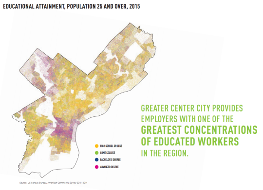
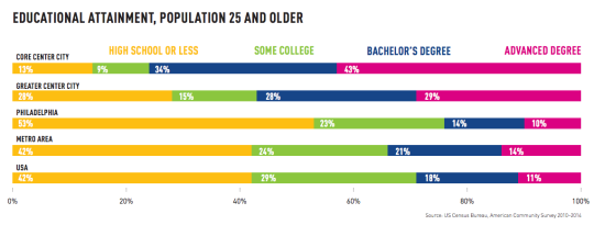
    If you take a look at the report, one of the first things you’ll probably notice is the concentration of jobs and the concentration of knowledge works (with advanced degrees) in the Center City area. We are seeing this shift in so many cities around the world.

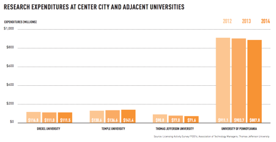
    Here are a few graphics (all of which are from the report):

    imageimage

    Part of the reason for this is that Center City is anchored by a number of fantastic Universities. This is critical for cities, today.

    image

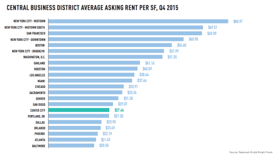
    To end this post, I thought I would post the below comparison of average office rents in major CBDs across the US. I always find these charts interesting, even though the usual suspects are up at the top.

    image

    I hope you’re all having a great holiday weekend.

  • Have your say in the future of downtown Toronto

    I was recently on a call with someone living in California, but who is originally from Toronto. He told me that every time he comes back to Toronto to visit, it feels like the city has changed, grown, and become even more cosmopolitan.

    That is a great compliment, because every city today is in a competition to remain relevant. Which means that if a city is not changing, evolving, and adapting, then it is falling behind. Competition is fierce and it’s global.

    Toronto is fortunate enough to be experiencing rapid population growth and that is driving a lot of this change. But at the same time, it naturally raises questions about how to best manage and leverage that growth, particularly in areas like the downtown core where a lot of that intensification is happening.

    To that end, the City of Toronto has been working on a three year study called TOcore, that will, among other things, result in a new comprehensive plan for the downtown core. (I’ve blogged about this before and it has come up in the comments a few times.)

    Today, however, marks the start of their public engagement process. And so if you’d like to have your say (there will be implications for developers, architects, and other city builders), you can do that here. There’s an online survey, an email address, events you can attend in person and, of course, a hashtag: #DTadvice.

    But the tool I think is really neat, is their “Favourite Places” map. What it allows you to do is drop pins onto a map of downtown and describe your “Favourite Places” and places that have “Great Potential.” Notice that the focus is on positivity. There’s no pin for “Shitty Places.”

    I have a lot to say, so I’ve been flooding the map with pins. I would be curious, though, to hear what you would like to see happen in downtown Toronto – and so would the TOcore team.