Daily insights for city builders, delivered every morning at 6 AM ET. I’m Brandon Donnelly — a Toronto-based real estate developer and founder of Globizen. I’ve been writing here since 2013.

Tag: cycling

  • Crowdsourcing unsafe cycling conditions with a small yellow handlebar button

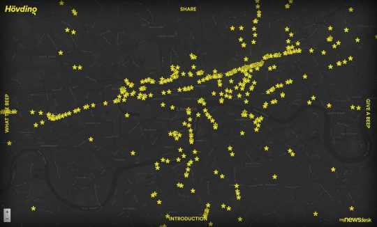
    Hövding – a Swedish company best known for its radical airbag cycling helmets (definitely check these out) – is currently crowdsourcing unsafe conditions and cyclist frustration in London.

    Working with the London Cyclist Campaign, they distributed 500 yellow handlebar buttons. Cyclists were then instructed to tap these buttons whenever they felt unsafe or frustrated with current cycling conditions. 

    Here’s what the button looks like:

    Every time the button is hit, the data point gets logged to a public map and an email gets sent to the Mayor of London reminding him of his promises around cycling. Both of these things happen via the rider’s smartphone.

    Here’s what the public map looks like at the time of writing this post:

    Not only does it tell you pain point locations, but it also seems to suggest the primary cycling routes. I think this is a brilliant initiative because, it’s entirely user-centric. It’s telling you how people feel on the ground.

    Supposedly, Hövding is actively looking for other cyclist groups around the world to help them distribute their buttons. So if you’re a group in Toronto or in another city, I would encourage you to reach out to them. The more data the better.

  • Barcelona’s new superblocks

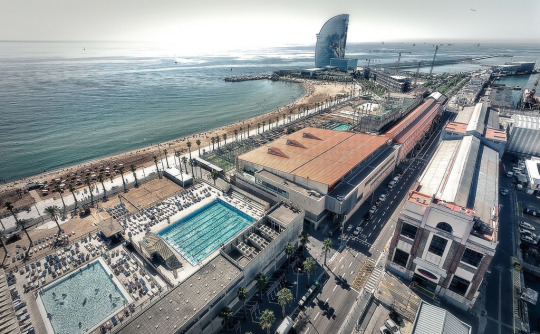
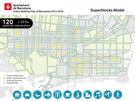
    Barcelona is in the midst of dramatically rethinking its urban fabric to address issues around urban mobility and climate change. Initially laid out in this 2014 Urban Mobility Plan for Barcelona, the city is now implementing something it calls superilles (or superblocks in English).

    Here’s what it looks like:

    The idea is to concentrate transit and vehicular traffic onto the edge of these new superblocks and then convert the interiors into livable spaces for pedestrians and cyclists. Here’s a description from the Agència d’Ecologia Urbana de Barcelona:

    “Superblocks are made up of a grid of basic roads forming a polygon, some 400 by 400 meters, with both interior and exterior components. The interior (intervía) is closed to motorized vehicles and above ground parking, and gives preference to pedestrian traffic in the public space. Though the inner streets are generally reserved for pedestrians, they can be used by residential traffic, services, emergency vehicles, and loading/unloading vehicles under special circumstances. The perimeter, or exterior, of Superblocks is where motorized traffic circulates, and makes up the basic roads.”

    The result is going to be an absolutely radical shift in the amount of public space given to drivers, pedestrians, and cyclists. When their 2014 report was issued, it was estimated that 73% of public space was allocated to cars (versus pedestrians). This plan will completely flip that ratio. With the superblock model, it is estimated that 77% of public space will now be allocated to pedestrians.

    Here’s what that is expected to look like…

    Before:

    After:

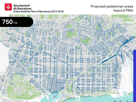
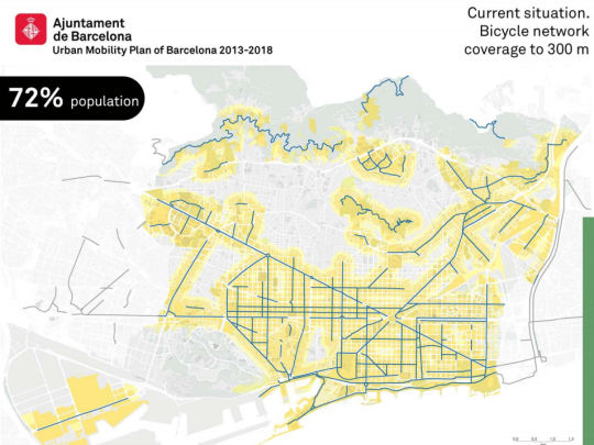
    There are also plans to expand the bicycle network to roughly 95% of the city’s population.

    Before:

    After:

    If any of you are from Barcelona, I would love to hear a local perspective on this mobility plan. Were and are there cries of a war on the car?

    Images: Top image from Tom Walk (Flickr); Maps from Urban Mobility Plan of Barcelona 2013-2018

  • The ROI of cycling infrastructure

    Toronto can’t make up its mind right now as to whether it would like to invest in additional cycling infrastructure. 

    Of course, we have a history of vacillating on topics like this. And I think it’s because we’re at a tricky inflection point. We are weaning ourselves off of the car, but most parts of the city remain underserved by transit and heavily dependent on the car.

    So today I thought I would share some numbers from a research study that was published last year by Stefan Gössling of Lund University and Andy S. Choi of the University of Queensland. It’s called, Transport transitions in Copenhagen: Comparing the cost of cars and bicycles.

    Much of the focus of the paper is on the cost-benefit analysis that the City of Copenhagen uses to make its cycling investment decisions. Here is an excerpt from ScienceDaily:

    “If the costs to society and the costs to private individuals are added together, the impact of the car is EUR 0.50 per kilometre and the impact of the bicycle is EUR 0.08 per kilometre.

    The study by Stefan Gössling and his colleague also shows that if we only look at costs/benefits for society, one kilometre by car costs EUR 0.15, whereas society earns EUR 0.16 on every kilometre cycled.

    “The cost-benefit analysis in Copenhagen shows that investments in cycling infrastructure and bike-friendly policies are economically sustainable and give high returns,” says Stefan Gössling.”

    So there you have it. Now I thought we could debate this in the comment section. Your thoughts?

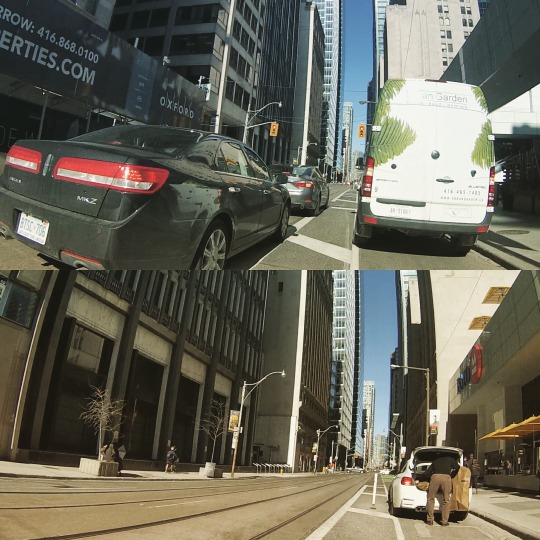
    P.S. The images at the top of this post were taken by me using my new GoPro bicycle handlebar mount.

  • Building Toronto Tomorrow

    I’m going to be speaking on a panel on May 3rd, here in Toronto, called Building T.O. Tomorrow. The topic is the future of this city.

    It is being put on by the good folks at BuzzBuzzHome and it will be held in the lobby of Allied’s new Queen-Richmond Centre (134 Peter Street). If you haven’t yet been to this building, that alone makes attending worthwhile.

    Here’s the event poster:

    If you’d like to attend, make sure you RSVP to aleks@buzzbuzzhome.com.

    On a largely unrelated note, I recently picked up the handlebar bicycle mount for my GoPro and I’m looking for some fellow city geeks who would like to ride around the city and film some – potentially cool – videos.

    I find that being on a bike is one of the best ways to experience a city (at least the cities that are actually bikeable). So I’m hoping some of that magic will translate into video. If that sounds at all interesting, drop me a line.

  • Changing Lanes — A fireside chat with Jennifer Keesmaat and Janette Sadik-Khan

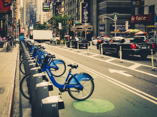
    Citi Bike by Pete  on 500px.com

    https://500px.com/embed.js

    When I was in Miami at the beginning of this month I missed an interesting event that I normally would have attended. It was a conversation between the Chief Planner of Toronto, Jennifer Keesmaat, and the former commissioner of the New York City Department of Transportation, Janette Sadik-Khan.

    Sadik-Khan was appointed under the Bloomberg administration and quite famously oversaw a huge number of urban changes in New York. Projects such as the addition of hundreds of kilometers of new bike lanes and the creation of 60 new pedestrian plazas across the city – including the one in Times Square.

    I was bummed I couldn’t attend, but thankfully Keesmaat wrote a post on her blog following the event and the Metcalf Foundation shared videos of the conversation. 

    Here’s a piece that I liked from Keesmaat’s blog post:

    “But she also pointed out that when they demonstrated what could be done, when they quickly mobilized around action, residents clamoured for similar changes in their neighbourhoods. Not surprisingly, this is why her book is called Streetfight – because it is a fight. City building is often the battle of ideologies, and when you’re trying to change the status quo, there is always a significant demographic of the population that is fully committed to maintaining business-as-usual.”

    If you have some time, you can also click here to watch the videos. There’s about an hour and a half worth of video, so you might want to open up a bottle of wine or something.

  • We are all selfish bastards

    cyclist on bike lane by Axel Bueckert on 500px.com

    https://500px.com/embed.js

    We are all selfish bastards when it comes to sharing road space and public space.

    When we drive, we complain about pedestrians jumping out in front of us, crazy cyclists who get in our way, and under-utilized bike lanes that are taking away valuable driving space and creating traffic jams.

    When we take surface transit (such as buses and streetcars), we want all the cars out of the way so that we can move more efficiently. And we complain about drivers who don’t stop to let us off and on when the streetcar doors open. (Toronto specific reference.)

    When we cycle, we complain about cars parked in the bike lanes, people who don’t look before changing lanes or opening their car doors, and drivers who honk at you because they just want you off the road and onto the sidewalk.

    And when we walk, we complain about cyclists who ride on the sidewalk (they should be on the road!), cars that don’t stop to let us go, and slow walking groups who linearly block the entire sidewalk so you can’t pass.

    We are never happy. And we automatically assume that we could do it better. (I know I’m guilty of this.)

    But here are a few things to consider the next time you’re flipping the bird to someone on the streets. Here are a few things that we do know about urban mobility.

    There is an unprecedented number of condominiums in the development pipeline right now in Toronto. For argument’s sake, let’s assume 75,000 condominium suites – many of which will be built in central areas of the city.

    At a parking ratio of 0.6 stalls per unit, which isn’t an unreasonable assumption today, that’s 45,000 new parking spots and potentially 45,000 new cars in the city. 

    If you think that 45,000 new cars will be able to get fully absorbed into the core and somehow move around in an unfettered way, then I believe you are mistaken. 

    If you think that there’s something that can be done to magically expand road capacity to handle all of these additional cars in the city, then I believe you are mistaken.

    And if you think that adding a bike lane is the only reason you are currently stuck in traffic, then I believe you are missing the bigger picture.

    Over a decade ago, we made a decision in this region to encourage building up, instead of building out. And along with that decision came a necessary rethink of how we get around. That transition is what we are living through right now.

    The other thing we know is that the 4 modes of mobility that I started this post with are ordered from least sustainable to most sustainable. 

    Electric self-driving vehicles will reduce the impacts of driving, but it will also transform it into something that feels more like transit and less like the driving we know today. That will be a very good thing.

    But I’m not yet convinced that it will solve all of our problems. To do that I think we will need to adopt a much more balanced and unselfish view of what it takes to move around a city. That, of course, isn’t always easy.

  • Munich is planning an ambitious…Radschnellverbindungen

    On Monday of this past long weekend, I went for a quick bike ride over to the Beaches, up to Little India, and then back down to the St. Lawrence Market. 

    The ride along Lake Shore and through the Beaches is one of my favorites. Minus a few awkward twists and turns as you leave the East Bayfront, it’s generally smooth sailing. It feels a bit like a bike highway.

    It took me about 24 minutes to get to the beach, which means I was traveling on average just over 20 km/h. If you lived in the Beaches and worked downtown, that would be a perfectly reasonable commute in my mind.

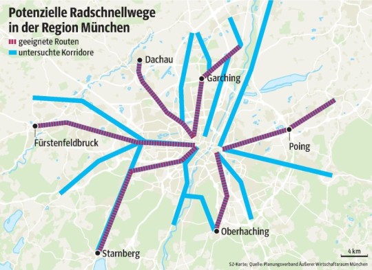
    And it’s for reasons like this that Munich is looking to invest in a huge network of bike highways. They’re calling it a Radschnellverbindungen – which I might start ambitiously calling some of the bike paths in Toronto – and the idea is to connect the city with all of the suburbs.

    Below is a map of the routes they’re looking at. The purple lines are “suitable routes” and the blue lines are corridors they’ve looked at it. If I’m wrong in my translation, blame Google.

    They are still in the feasibility stage, but the idea is for each bike path to be 4 meters wide and have no cross streets or traffic lights – essential a highway for bikes.

    And if you think this all sounds like a pipe dream, check out this video of the recently opened Cykelslangen (Cycle Snake) in Copenhagen.

    [youtube https://www.youtube.com/watch?v=iypvbe6J6Qs?rel=0]

    Would you commute to work on your bike if you had a highway, just like cars do?

  • Saturday morning bike ride to the Bluffs

    This morning I got up at 7:30am and met a good friend of mine at the St. Lawrence Market for breakfast.

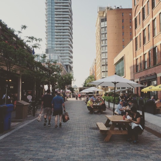
    Market Street is closed to cars today so it’s pedestrian-only. It should be this way all the time. They had a pig roasting on a spit when I walked by and a big stage set up. 

    Below is a photo of what it looks like. Keep in mind that this photo was taken just after 8:00am, which is why it’s not all that busy, yet.

    image

    When Market Street was redone a few years ago, the original vision for the street was for it to be pedestrian-only. But somebody told me that the city didn’t want that. Too bad. It strikes me as a perfect candidate for that.

    After breakfast, we then biked out to the Scarborough Bluffs in the east end of the city. If you click here, you can see the path we took via Strava. It’s only about 15km from downtown. The ride through the Beaches was by far the best stretch. The water was on my right hand side. The pavement was smooth and continuous. And I had George FitzGerald on my headphones for pacing.

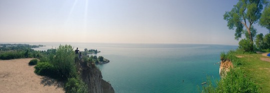
    When we got there, this was the view we were presented with:

    image

    It honestly doesn’t feel like Toronto. The water is turquoise and there’s a beautiful beach at the bottom of the cliffs. It felt like paradise.

    If you’ve never been to the Scarborough Bluffs, do yourself a favor and get out there on a beautiful summer day. It’s the dog days of summer and Toronto is a magical place right now.

  • How urban density affects how you get around

    Yesterday I wrote about urban-suburban divides within cities. And I argued that built form will largely dictate the kinds of transportation choices that people will ultimately make.

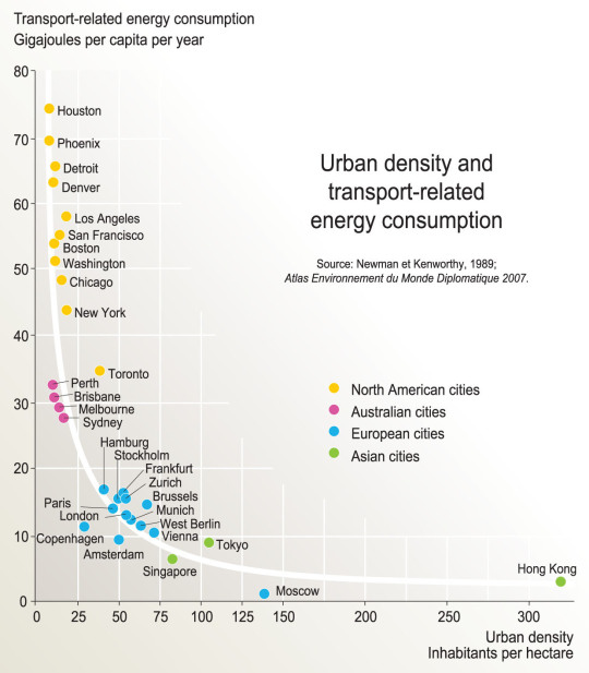
    As a follow-up to that, here is a chart based on the findings of a research report completed by Peter Newman and Jeffrey Kenworthy way back in 1989. On the x-axis is urban density (i.e. built form) and on the y-axis is per capita transport related energy consumption.

    image

    What this chart shows is that as cities become more dense, “automobile dependence” is reduced in favor of, other, more sustainable forms of transport. 

    Here we have Houston at the top left (meaning it has the highest transport-related energy consumption per capita) and Hong Kong all the way on the bottom right. Hong Kong has by far the highest density among the cities looked at in this study, but Moscow seems to have the lowest per capita energy consumption. Still, the trend appears clear.

    Some people think of “density” as a dirty word. But there are lots of benefits to dense urban centers. And density does not necessarily have to mean tall buildings.

    Chart: Globalization Studies in an Urban World (Penn)

  • Before & After: Queens Quay Boulevard

    Yesterday I spent the evening walking Toronto’s new Queens Quay Boulevard, which fully reopened this past Friday after a number of years of construction. 

    It is part of Waterfront Toronto’s revitalization efforts and represents a solid decade in the making. West 8 of Rotterdam and DTAH of Toronto won the international design competition for the central waterfront back in 2006. And this past weekend a big component of that vision was unveiled.

    But first, let’s take a look at what Queens Quay Boulevard used to be like. Here’s a Google Streetview image from 2009:

    image

    The streetcars ran in the middle of the street. Cars drove on the north and south side on both sides of the tracks. And the sidewalks were fairly small and usually at capacity during the busy summer months. It wasn’t a great street.

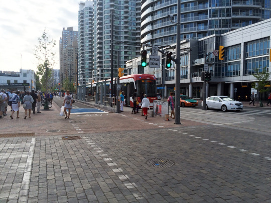
    Now here’s a photo that I took yesterday from that same vantage point (2015):

    image

    The street has been completely reorganized. On the north side of the streetcar tracks is where the cars now drive in both directions. On the south side of the tracks the lanes of traffic have been replaced with a 2-way bike trail (part of the Martin Goodman Trail). And on both sides the pedestrian areas have been greatly expanded. It’s now a magnificent street.

    If you haven’t yet been down to the new Queens Quay, I would encourage you to check it out on either foot or bicycle. (If you go on bicycle, let me know and I’ll join you.) 

    Toronto may have taken a giant step backwards with its recent decision on the Gardiner East, but we also took a giant step forward with the reopening of Queens Quay Boulevard.