Daily insights for city builders, delivered every morning at 6 AM ET. I’m Brandon Donnelly — a Toronto-based real estate developer and founder of Globizen. I’ve been writing here since 2013.

Tag: city

  • Solving the rubik’s cube

    Developing a building can often feel like you’re trying to solve a rubik’s cube. Among other things, you have to manage a myriad of different stakeholders, all of which — naturally — operate in their own self-interest. There’s the city, community, politicians, various agencies, consultants, tenants, purchasers, lenders, investors, the market at large (of which you really have no control of), and many others. Oftentimes you even have stakeholders whose interests are mutually exclusive. Indeed, the things that they want can sometimes be at odds with each other. Your job is to figure out a solution that satisfies as many of these interests as possible.

    To give you an example, let’s say that you’ve been asked to introduce a stepback into your building in order to break up the elevation. From an urban design standpoint, this may make perfect sense. Hello, datum line. But now your construction costs just went up. You have to transfer your mechanical lines, insulate the roof, introduce new bulkheads, and, for the purposes of this example, let’s say you now need to introduce a structural transfer. This is big cost item that you hadn’t accounted for. And because you just reduced the height of the building to satisfy another stakeholder, you don’t have the excess clear height to accommodate the additional depth required by this new structural element. There is, of course, always a solution. But usually something will need to give.

    At the same time, this raises some interesting philosophical questions. What’s more important in this example? The urban design move or keeping construction costs low so that the building can be delivered more affordably? The cynics will argue that this is a moot point because developers will always profit maximize. But I would encourage you to check out some of my past posts, such as “Cost-plus pricing” and “The impact of inclusionary zoning on development feasibility.” This problem solving dynamic is one of the things that makes development so challenging. But it is also one of the things that makes it incredibly rewarding.

    Photo by Ivan Bandura on Unsplash
  • How London became the center of the world

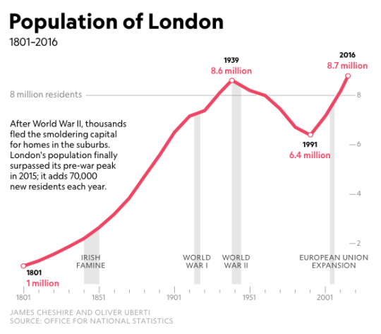
    Some of you may want to debate the “center of the world” title (New York may be more deserving), but Laura Parker of National Geographic recently published a great essay describing the tremendous growth that London has seen over the last 30 years thanks to in part the deregulation of the financial services industry. Here is an excerpt:

    As the manufacturing industry splintered, the docks of what was once the world’s largest port fell victim to shipping modernization and closed. The death in 1965 of Winston Churchill, the great prime minister, marked “the last time that London would be the capital of the world,” the Observer noted. Population continued a downward slide, bottoming out at 6.7 million in 1988. By then London’s fortunes had changed with deregulation of the financial services industry, known as the Big Bang, along with the shift to electronic trading, which enabled London to rival Tokyo and New York. A new financial district rose on the ruins of the West India Docks on the Isle of Dogs, a marshy nub that juts into the Thames. Canary Wharf, as the district is called, became London’s first modern large-scale regeneration project.

    According to National Geographic, London’s population grew by about 1.2 million between 2006 and 2016. That’s a pretty incredible number and is why the city estimates that they need about 66,000 new housing units a year just to keep up the growth. Like many supply constrained big cities, they’re not meeting that target.

    For the full essay, click here. It comes packaged with some incredible photographs by Luca Locatelli.

  • Last-mile electric scooters — will they work?

    I’ve been hearing a lot about Bird recently. Perhaps it has something to do with the $15 million Series A round they raised last month (February 2018) and the $100 million Series B round they announced earlier today.

    A “Bird” is small electric scooters that look like this and can be rented from your phone for short haul trips. They are currently available in Santa Monica, Venice, UCLA, Westwood, and San Diego, and they are intended to be ridden in existing bike lanes.

    What may be particularly interesting to this blog audience is the fact that Bird is calling itself a “last-mile electric vehicle sharing company.” The pitch: 40% of car trips (in the US?) are less than 2 miles long. Let’s replace those using electric scooters.

    One of the first things that came to my mind is that this feels more accessible than cycling. Cycling to work can be a commitment. You have to think about your attire and the sweat factor, among other things.

    Would you agree?

  • Some thoughts on how we plan cities

    I came across this discussion on Twitter yesterday about how so many of the spaces we love in cities would not conform to today’s modern city planning practices:

    //platform.twitter.com/widgets.js

    This is a topic I’ve been thinking about lately and so it’s a timely discussion. In fact, I’ll often come across spaces in Toronto where I’ll think to myself: This is a really great space. But it’s highly unlikely that it could be built this way today. Naturally the question then becomes: What does this say about modern city planning?

    City planning is obviously important. But at the same time, we are almost certainly making mistakes and doing things that we will later regret. I say this not because I’m particularly critical of planning today, but because cities are enormously complex entities and it’s difficult to believe that we’ve figured everything out at this point.

    One thing I wonder about is if we aren’t over-planning and being too prescriptive about our cities. Some of you will probably argue the exact opposite. But hear me out.

    Vancouver is a city that has long been considered to be the gold standard in modern city planning. We talk about its podium + tower building typology. We talk about its “gentle density.” And we talk about its great public and recreational spaces, among many other things.

    But when I was there last month having dinner with a friend of mine, she said something to me that stood out. She said: “Brandon, Vancouver is a boring city. If it weren’t for my family being here, I would happily move to Toronto, New York, or somewhere else.”

    Cities are amazing places because they unleash human ingenuity. They allow new and unforeseen things to emerge. The challenge, I think, is to not sterilize that away when we plan and build. And all of us involved in the building of cities are probably guilty of doing that to an extent.

  • Building Toronto Tomorrow

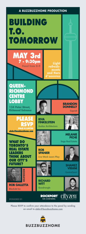
    I’m going to be speaking on a panel on May 3rd, here in Toronto, called Building T.O. Tomorrow. The topic is the future of this city.

    It is being put on by the good folks at BuzzBuzzHome and it will be held in the lobby of Allied’s new Queen-Richmond Centre (134 Peter Street). If you haven’t yet been to this building, that alone makes attending worthwhile.

    Here’s the event poster:

    If you’d like to attend, make sure you RSVP to aleks@buzzbuzzhome.com.

    On a largely unrelated note, I recently picked up the handlebar bicycle mount for my GoPro and I’m looking for some fellow city geeks who would like to ride around the city and film some – potentially cool – videos.

    I find that being on a bike is one of the best ways to experience a city (at least the cities that are actually bikeable). So I’m hoping some of that magic will translate into video. If that sounds at all interesting, drop me a line.

  • The city as an egg

    This week I have been thinking and reading about monocentric and polycentric cities. In urban real estate economics, the monocentric city model has historically been an important economic model. Developed in the 1960s, it attempts to explain land use in cities with one core, or central business district (CBD).

    In its most simplest terms, the model states that as you move further away from that core, land prices will fall. But since retail and employment need to be at the center of large catchment areas, they will remain in the middle, while the residential will naturally spread out.

    When you begin to factor in transportation costs, there is an argument to be made for why inner cities neighborhoods were often poorer in North American cities (no car; higher transportation costs) and why the suburbs were often wealthier. In this latter case, the rich wanted to consume more home/real estate and their transportation costs weren’t as significant. They had cars and subsidized highways in which to drive them on.

    Of course, there are many ways in which you could argue against the above. Today, urban neighborhoods are some of the most desirable areas in many cities. 

    But perhaps the most obvious thing to question is the idea that cities only have one central business district. I mean, just look at all the employment nodes in Toronto. Yes, downtown Toronto is still the dominant zone, but could we really be considered monocentric?

    From what I remember, the model had mechanisms for dealing with polycentricity. But at the same time, so much has changed since the 1960s. The central business district with its big department store was only just getting introduced to the likes of fully enclosed, climate-controlled suburban malls. And of course today, we are now living in a world of Amazon Prime and independent workers.

    So what does this mean for cities?

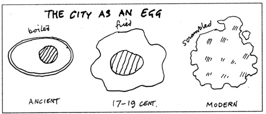
    Well, as I was reading up on this topic I stumbled upon this diagram by architect Cedric Price (1934-2003):

    I wish I knew exactly when this diagram was created, but I wasn’t able to find that online. In any event, the diagram uses different kinds of eggs – boiled, fried, and then scrambled – to explain the urban morphology of cities over time.

    In the ancient world, cities had a clearly defined core and a clearly defined perimeter – often a wall for defence (boiled egg). In the 17-19th centuries, cities started to expand outwards through the advent of technologies like rail. This gave them a more irregular shape (fried egg). And then finally, Cedric argues that the modern city had, or would, become all mixed together like scrambled eggs.

    I wouldn’t say that our cities have become completely scrambled. But I would agree that we are moving away from the simple fried egg of a city (or monocentric city model). So I guess the big question is really: How scrambled do you think we’ll get?

  • Toronto already has a laneway community on the islands

    image

    It feels really good to have shared the details about my laneway project yesterday. It’s a project I’ve been working on for a few years now, and – though I’ve spoken to architects, engineers, and city staff about the project – I hadn’t really gone public with it. And I’m happy I did.

    I got a lot of great feedback from the twittersphere. In fact, I didn’t receive one negative comment about the idea of a laneway house in Toronto. Everyone seemed to think it was a great idea and many expressed their dismay with the city’s reticence to formally support them.

    I also received a number of encouraging emails, one of which was from a resident of the Toronto Islands. And he raised a really great point: Toronto already has a very successful community of laneway-like houses and it’s called the Toronto Islands.

    The streets are no wider than the laneways we have here on the mainland (and even smaller in some cases) and yet there are about 250 houses serving a population of roughly 750. He went on to mention that they even have “downsized garbage trucks”, which are used to navigate the small, car-free streets of the Toronto Islands.

    What this reinforces is that our aversion to laneway housing is not because we can’t figure out the logistics of how to service them. We can and are already doing that. If we can figure out how to do that on the islands, I’m pretty sure that we could also figure out how to do it on the mainland. 

    So what this really comes down is that there isn’t the political will to make this happen. And there isn’t that will, I’m guessing, because there’s a fear of upsetting the established neighborhoods. That’s why Ontario’s Places to Grow Act (2005) was deliberate in concentrating growth in specific areas of the city – it meant that we could say that the rest of the city would receive little to no growth.

    We’ve since revised that position with the push to intensify our Avenues with mid-rise buildings. But just as we went from high-rise to mid-rise intensification, I think it’s only a matter of time before low-rise intensification starts to also happen.

    I firmly believe that the demand is already there for laneway housing (the Lanehouse on Bartlett pretty much sold out in one evening). It’s simply a matter of now figuring out the supply side of this equation.

    Image: Ward’s Island (Toronto Islands)

  • Comprehensive to the core

    The City of Toronto recently started an initiative called “Comprehensive to the Core.” It’s a look at how downtown Toronto–which is growing at 4 times the rate of the rest of the city–should continue to grow moving forward so that it remains a great place to live, work, learn and play.

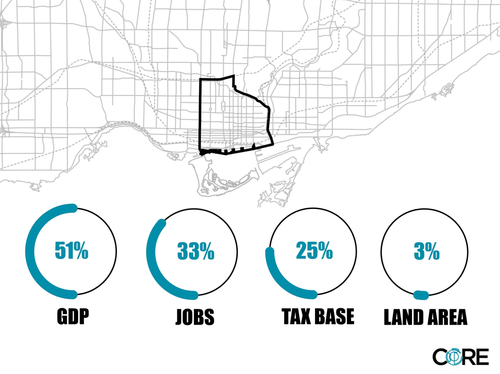
    Here’s a presentation that was delivered last month by the city. It’s mostly infographics and so it’s a quick and fun read. And here’s an infographic that does a nice job of summarizing what’s happening in the core of Toronto.

    What it’s saying is that downtown Toronto–which they consider to be bound by Bathurst Street in the west, the Don Valley Parkway in the east, the lake in the south, and Dupont Street in the north–is responsible for 51% of the city’s entire GDP. It’s also responsible for 33% of all jobs in the city and 25% of the city’s entire tax base. And yet in terms of size, it represents only 3% of the city’s land area.

    That’s a powerful reminder of the economic potential of density and agglomeration economies. It’s also a reminder that we shouldn’t let politics deprive our economic engine of the services and investments it needs.

  • How I walked today

    A couple of months ago I picked up a FitBit Flex. For those of you unfamiliar with the wrist device, it’s similar to the Nike FuelBand.

    I bought one for really two reasons.

    The first is that I think it’s pretty clear at this point – with Google Glass and rumours of an Apple iWatch – that wearable computing will eventually be a massive market opportunity. Who knows, it could do to mobile what mobile did to PCs.

    The second reason is that I love data. I love measuring and tracking things. And it’s probably the main reason I use apps like Foursquare fairly regularly.

    To this end, here’s how I walked today:

    It’s pretty typical for a day of commuting: To the office in the morning; out and about at lunch; and then back at the end of the day.

    In terms of the value I get out of this, it’s more for novelty than anything else at this point. The FitBit app has a lot of features to track caloric intake and other things, but I only use it to track things it can do passively.

    That said, I like being able to quickly see how close I am to my daily step goal of 15,000. On most days I don’t hit it.