Daily insights for city builders, delivered every morning at 6 AM ET. I’m Brandon Donnelly — a Toronto-based real estate developer and founder of Globizen. I’ve been writing here since 2013.

Tag: city of toronto

  • What it takes to unlock infeasible development land (and some thoughts on parking)

    image

    One of the questions that came up after my recent post about land pricing was: what is it going to take to develop underutilized land on the outskirts of city centers?

    So today I thought I would talk about a new development project that was also discussed at the Land & Development conference I recently attended. I think will begin to answer this question.

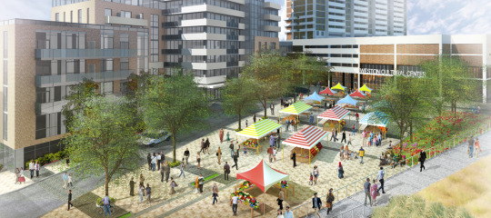
    The project today is known as the Rockport Weston Community Hub & Rental Building. And it’s going to include a community cultural hub, 26 live/work artist spaces, and 300 rental apartments. 

    It’s located in the Weston neighborhood of Toronto, which is designated as a “Neighborhood Improvement Area.” These are lower-income areas that the city considers to be “at-risk.”

    Given this, rents are naturally lower here than in other parts of the city, which means that it’s basically infeasible to develop here. There has been no large scale development in this community since the 1970s!

    To put some numbers to this, the developer said they were projecting rents somewhere around “two and a quarter.” So let’s assume for a second that the average apartment rents will be $2.25 per square foot. 

    At this rate, it means that a 600 square foot one-bedroom apartment will have a face rent of $1,350 per month. This may seem fairly high, but it almost certainly wouldn’t be enough to get a project like this off the ground under normal market conditions. At least, that’s the case here in Toronto with current cost structures.

    So what had to happen was a fairly complicated public-private partnership, which you can read all about here. But at a high level, there seems to have been 3 main economic factors that allowed this project to move forward:

    1) The developer was able to acquire the land for cents on the dollar. As I said in this post, land is expensive. So this helps a lot.

    2) The developer was able to make use of extra parking in an adjacent building. Assuming that underground parking could cost around $50,000 per stall, this is a huge cost savings.

    3) Lastly, the project is benefiting from the public invest made in the airport rail link that now quickly connects this site to both Pearson International and downtown Toronto.

    The moral of the story is that infeasible sites require some sort of subsidy or top up to make them work. Or, there needs to be an exceptional circumstance. Because if the rents aren’t there, nobody is going to build. It’s as simple as that.

    That said, here’s one idea…

    This discussion reminds me of a post I wrote a while back called, The hypocrisy of parking minimums. Frankly, I don’t understand why a city like Toronto still has parking minimums. If anything, we should have parking maximums.

    Underground parking is a huge cost that has to get carried by purchasers and renters in a new building. For example, let’s assume that 300 apartment suites would require 180 parking stalls (ratio = 0.6). Assuming $50,000 per stall, that’s a $9 million cost.

    So the second takeaway is that it’s probably time we took a good hard look at how we think about and plan for parking in our cities. Especially since the entire mobility space is being quickly disrupted.

    Image: Rockport
  • Toronto exploring road pricing on downtown highways

    Road pricing is on the table in Toronto. (Somebody has to fund the expensive Gardiner Expressway East rebuild.) On March 11, 2016, the City issued a Request for Proposal for: “Options for Establishment of Toll Facilities on F.G. Gardiner Expressway/Don Valley Parkway.”

    As a vocal supporter of road pricing, I am happy to see us headed in this direction. And I bet that today’s post will just be the beginning of my ruminations on this topic.

    Because naturally, it raises a lot of questions:

    Should the pricing be fixed or variable? Similar to how Uber’s surge pricing model is intended to ensure that there are always enough drivers on the road, should our road pricing model strive to eliminate traffic congestion by increasing the price of the road as demand rises beyond road capacity? I like the idea of a “congestion charge” rather than just a road toll. There’s something very efficient about it.

    Who should pay? Should anyone and everyone who uses the road pay? Or should it just be be non-Toronto residents who aren’t already paying property taxes in the city? I would imagine that this latter scenario would be easier for Toronto politicians to get behind, since there will obviously be a segment of people who flat out don’t want road tolls/pricing. But if we stick with the principle that it’s a “congestion charge”, then everyone should pay. It doesn’t matter where you live when you are demand trying to exceed the available supply of road.

    (I’m running a Twitter poll right now with this exact question. At the time of writing this post, “everyone should pay” is winning.)

    Should electric vehicles be exempt from the road tolls or congestion charges in order to help accelerate our transition away from fossil fuels? With Tesla getting ready to announce its mass market Model 3 (price $35,000), I’ve been thinking lately that the car I currently own may very well be the last gasoline car I ever own.

    It’s still early days for road pricing and our mayor doesn’t seem to be a fan. So who knows how far we’ll get with this RFP. But I for one hope that we find the courage to make the difficult decisions and that this new revenue stream is leveraged for the purpose of building more sustainable forms of urban transport in this city. 

    Let’s make a 50 year decision and not an election cycle decision.

  • Toronto’s rapid transit network by 2031

    Starting today and running until the end of March, the City of Toronto, the Toronto Transit Commission, and Metrolinx will be hosting several public meetings as they work towards planning out this city and region’s rapid transit network.

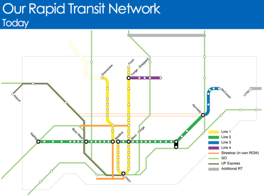
    Below are a few of the key maps from their presentation.

    Here is what Toronto’s rapid transit network looks like today (the hollow lines represent projects in construction):

    image

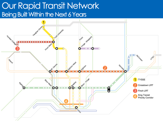
    Here is what will be built within the next 6 years:

    image

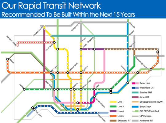
    And here is what they are recommending should be built within the next 15 years:

    image

    It’s hard not to get excited when you see maps like this. Of course, it’s a lot easier to draw lines on a map then it is to fund and execute on projects like this.

    But I think it all starts with us acknowledging that these initiatives are critical to both our economic competitiveness as a city region and our quality of life as citizens of it. Because if this is something we really want, then we can absolutely make it happen.

    Click here if you’d like to see the full presentation and also the public meeting dates/times.

  • Housing completions in Toronto from 1996 to 2014

    Whenever I read studies that cite census data, I’m often left feeling like the data is out-of-date. 

    Five years – which is how often Canada conducts its national census – is a long time. Somebody could move to this country for school, complete a 4-year degree, and then leave, and we wouldn’t even pick it up in our data.

    Thankfully, we’ve at least reinstated the long-form census for next year. Here are the questions, if you’re curious.

    But all of this is a digression. 

    This morning I read through a housing report that the City of Toronto published in October of this year. It’s about housing trends. And I wanted to share the below chart that covers housing completions for the period of 1996 to 2014. Keep in mind that this is for the City of Toronto, and not the Greater Toronto Area.

    What it shows is that over this 18 year period, 78% of all housing completions in this city have been either low-rise or high-rise condominiums/apartments. The remaining 22% is a mix of detached and semi-detached houses and townhouses.

    However, this 22% is an average. 

    Detached and semi-detached housing completions declined from 22% in the 1996-2001 period to 10% a decade later. And row and townhouses declined from 16% to 6% during this same period.

    At the same time, “many” of the housing units in this 22% were actually replacing existing and older housing stock. That is, according to the report, many were “knock-downs” and rebuilds. In these cases, it means that the completions actually do not represent net new housing units. So in reality, the supply of new single-family housing is even lower than it appears in the chart above.

    When you look at all of this, it should come as no surprise to you that our current combination of low interest rates and low supply has been leading to huge price increases on the single-family side of the market.

    And it’s for this reason that I believe Toronto will eventually start to look towards allowing more low-rise intensification. Laneway housing, as one example, would represent virtually 100% new ground-related housing in already built up areas. Where else are we going to find that kind of housing opportunity?

    So in my view, it is a question of when, not if, this will happen.

  • Interview with Brad Keast of Osmington

    image

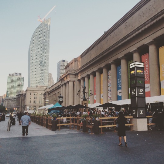
    Given yesterday’s post about Times Square in New York, the timing is perfect to talk about the revitalization of Union Station here in Toronto, its new public spaces, and the programming that’s now happening in and around the station.

    Perhaps the most noticeable is something called Front Street Foods @ Union Summer, which is an outdoor food market set up along Front Street. It’s on this summer from July 6th to September 27th, 2015. 

    However, Front Street Foods is only one part – the food part – of a larger events and programming strategy known as Union Summer. I recently had a quick chat with Brad Keast of Osmington, who is involved in a lot of what’s happening right now at Union Station.

    I found it interesting to learn about how organic the process was. And I thought you all might find it interesting as well.

    ————————————–

    Tell us a little bit about you and your company’s involvement with Union Station. 

    I’ve been with Osmington for over 4 years now and Union Station is a major focus of my waking life. 

    The company won a public RFP with the City of Toronto in 2009 to be the City’s retail partner in the redevelopment. What this means is that while the City owns the building and is doing base building construction, we are overseeing all the retail, advertising, and special events and programming. We are finding all the tenants, doing a bit of overshell work and then turning it over for fit-up.  

    We think the real special part of the project comes in through the special events and programming. We really want to make the station a destination in itself and you’re starting to see that with some of the programming we’ve done this year, be it a contemporary art event like Villa Toronto or something more community-focused like Union Summer – the current animation of the area in front of the station.

    How did the idea for Union Summer come about? 

    This really was a collaborative internal effort. We started by thinking ‘hey, let’s put a bunch of tables and chairs on the new plaza in front of the station and see what happens.’ Then we added in the idea of food. We knew it had to be accessible but didn’t want traditional food trucks, rather something less mobile but still not permanent. 

    That’s when we reached out to Toronto Market Company and they started rounding up the vendors. Then we layered on entertainment – daily music be it live or DJs, as well as a movie night with the Toronto International Film Festival (TIFF). We even have some kids programming on the weekends. Then we worked with the Farmers’ Market being displaced from Nathan Phillips Square due to Pan Am this year to have them here on Wednesdays.

    What was involved in making Union Summer a reality? What was the biggest surprise and/or hurdle that needed to be overcome? 

    There was a tremendous amount of coordination needed. First we weren’t sure when the construction was even going to be finished, all that was certain was it would be before Pan Am started. 

    Then the infrastructure required for the event itself was an exercise in creativity – power, water, and grey water disposal in particular. There was a lot of meetings with City officials for things like building permits, fire code, council approval to apply for a liquor permit, and health and food safety measures. Operationally things like loading in, coordinating with the installation of the Pan Am banners between the columns, interim furniture when our original order didn’t make it onto a ship in Antwerp, and then the first week was so busy that some vendors started losing staff because they were burnt out. 

    Like all things with this project we have to be mindful that this is an operating train station. In fact it’s the busiest building in the country with over 250,000 people per day passing through so we can’t impede those operations. We’ve done our best and have learned some lessons along the way and the reception has been overwhelming. 

    One of the best things about having that many entrepreneurs in close proximity is that some vendors have been pairing up to try experiments. Frozen custard-stuffed churro?

    Toronto is getting much better at designing and programming its public spaces. Given your experience with Union Summer, is there something the city could and should be doing to encourage more of these kinds of urban activations?

    Well, first of all, our contacts at the City, in particular Denise Gendron and Scott Barrett in Real Estate Services have been incredibly supportive of our efforts and we couldn’t have done it without them. If I could make one recommendation it would be to build in the supportive infrastructure for services. Of course that’s only beneficial if there is someone to take charge of the space and program it appropriately. It’s not a part time job.

    What’s next for Union Station?

    Right now the focus is on getting the first retailers open on GO’s new York Concourse. On the programming side we will host art for Nuit Blanche (October 3rd, 2015). That promises to be exciting. And then opening November 30th, 2015 is the Holiday Market. It was a huge success last year so we’re bringing it back for 3 weeks this time.

  • Those troublemakers

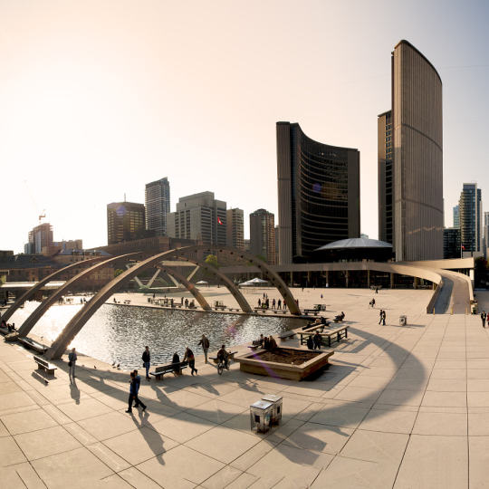
    Toronto City Hall by Sébastien Pacaud on 500px.com

    https://500px.com/embed.js

    Jennifer Keesmaat is the Chief Planner of Toronto. She was hired for this job in 2012.

    She has a Masters in Environmental Studies (Politics and Planning). She is a Registered Professional Planner with the Canadian Institute of Planners. And she was also the founder of 2 (city) planning firms prior to taking the position of Chief Planner for Toronto.

    So presumably, she was hired for this job because she possesses some sort of expertise in the realm of planning. I also presume that she is expected to make her opinions known to other people so that informed planning discussions can occur and decisions can be made.

    So I find it curious that in some circles, and in the media, Jennifer Keesmaat is being branded as a “troublemaker.”

    A lot of the recent chatter stems from the fact that Keesmaat was at odds with Mayor Tory during the Gardiner Expressway East debate (quote via Toronto Life):

    Eventually Tory had enough and pulled Keesmaat into a meeting where he basically told her to zip it. “The mayor has said it is perfectly appropriate for staff to make their opinions public, as Ms. Keesmaat has done,” wrote his communications chief, Amanda Galbraith, in a statement. “It is not appropriate for city staff to campaign against councillors or the mayor on social media or through other public platforms.” Keesmaat counters that she never campaigned. “I stated an opinion,” she says simply.

    But the “troublemaking” didn’t just start with the Gardiner East. Pretty much since the moment she took the position of Chief Planner and launched her own blog (ownyourcity.ca), she was dubbed a shit disturber. (Those bloggers!)

    But if you ask me, these criticisms stem from an old and outdated way of thinking.

    The last thing we need from government is less transparency and more politicking. We should be working towards more, not less, information. Even if that information doesn’t butter our metaphorical bread.

    What do you think?

    I think this will make for a great discussion in the comment section below.

  • A petition to Toronto City Council to remove the Gardiner Expressway East

    image

    “If the decision ultimately of the council is to support the hybrid I think frankly it’ll be a major step backwards and you’re going to miss a once in a lifetime opportunity, and I’ll be very frank, we’ll be the laughingstock of the world.” 

    -Paul Bedford, former chief planner of Toronto

    As many of you I’m sure know, I have been a vocal and passionate supporter of removing the eastern portion of the elevated Gardiner Expressway in downtown Toronto. I have written about it so many times that a lot of you are probably sick of hearing about it.

    I’m sorry if that’s the case. But it’s a hot and important topic in Toronto right now. We’re just over 3 weeks away from City Council finally making a decision. That is scheduled to happen on June 9th and/or 10th. 

    For the most part though, I was pretty confident that we would ultimately make what many of us believe is the right decision. But then this past week Mayor John Tory went public in his support for the “hybrid” option, which is basically to rebuild the elevated expressway in a slightly different configuration. And that really upset me.

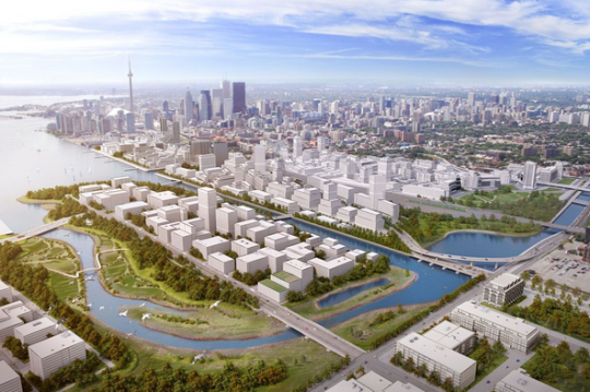
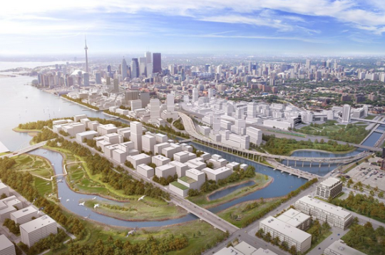
    Here’s what that looks like (versus the remove option shown at the top of this post):

    image

    Have we learned nothing from our past city building mistakes?

    Since that announcement, I went on Twitter every night this week to check out the discussions that were happening around #GardinerEast. And every night it got me so worked up that I then had trouble falling asleep. I have since stopped reading about the Gardiner East before bed.

    But rather than just get frustrated, my friend (a fellow city builder named Stephen Job) and I decided to do something about it and create a petition using Change.org.

    It is a petition that we will ultimately be sending to Toronto’s entire City Council prior to their June 9 meeting and we hope that you will consider signing it and sharing it with your network – regardless of whether or not you happen to live in Toronto. (Although it’ll certainly help if you’re a taxpayer and voter in the City of Toronto.)

    We just finished getting it up and you can check it out and sign it by clicking here.

    Images: Toronto Star

  • Our fixation with height

    image

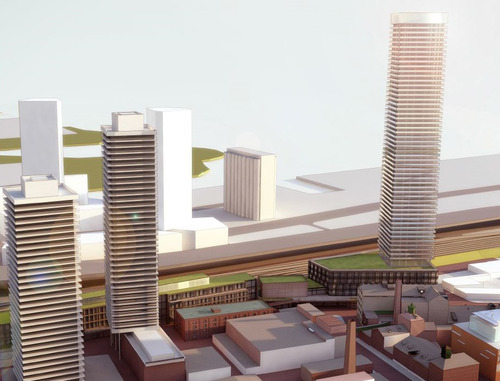
    Last summer a development application was submitted for a 57 storey mixed-use tower on the south end of Toronto’s historic Distillery District. 

    It’s the tower on the right hand side of the picture above. The 2 towers on the left are existing, although they’re quite recent. The development site is currently a parking lot and it abuts a railway corridor to the south.

    The reason I bring up this project now is because I recently saw this notice go out from the Gooderham & Worts Neighbourhood Association. It’s an announcement for a public meeting that I believe just happened earlier this week (I think they meant to say 2015 instead of 2014).

    After I saw the notice, I decided to share the rendering on social media to see what people thought of the proposal. The general consensus seemed to be that the tower looked a bit cookie cutter (though to be fair it’s hard to tell from renderings like this) and that 57 storeys was simply too tall for the area. I got comments back like “enough is enough.”

    Now, I’m not here to say that 57 storeys is exactly the right height for this building and this location (though it might be), but I am saying that I don’t think it’s as important as most people think it is. I think we’ve become over-fixated on height, at the expense of other important design issues.

    Part of this has to do with how we communicate projects and how we tell the story. If you look at the city’s website for this project, you’ll see that this is how it’s explained:

    The City has received an Official Plan Amendment and Rezoning application for a 57-storey mixed use tower and a 5-storey commercial building containing 496 residential dwellings, 5,048 square metres of retail gross floor area, and 21,243 square metres of office gross floor area. The 5-storey commercial building is within the Distillery District, and the 57 storey tower is immediately south west of the Distillery District.

    About the only thing that I think most people (outside of the industry) would understand are the heights of the buildings. Everything else – from the Official Plan Amendment to the number of square metres of gross retail area – is likely lost. 

    So it’s actually not surprising that most people just look at one or two renderings and the number of storeys, and then make a judgement call about whether or not it would be a positive thing for the city.

    Now, I know why we communicate projects in such a clinical way. It’s to appear impartial. But there are so many other considerations when it comes to great city building. 

    How does the building meet the street? What are the first couple of floors like at eye-level? What’s the materiality? What would the experience be like for someone having a coffee on a patio outside of the building? What kind of commercial tenants will there be? Is there a unique leasing/programming strategy? What’s the overall vision for the project?

    Again, I’m not saying that height is completely irrelevant. I simply fear that we might be losing sight of the bigger picture. The Distillery District is a magical place in Toronto. It’s hands down one of my favorite places to be. In fact, I’ll be there this weekend for a Winterlicious dinner. But I honestly couldn’t tell you how tall the existing towers are. Are they in the 40s? 

    I could, however, tell you exactly what it’s like to walk down the Distillery’s intimate cobblestone streets and sit on a patio with a beer in hand. It’s a beautiful thing.

    Note: I have zero affiliation with this project.

    Image: City of Toronto

  • Is Toronto’s urban growth boundary really making the city less affordable?

    image

    This morning the Globe and Mail published an article by Toronto’s chief planner, Jennifer Keesmaat, called Greenbelts make cities more livable, affordable and transit-friendly.

    The headline immediately caught my attention because conventional economic wisdom would suggest that supply constraints – whether natural or artificially created – generally have a negative effect on housing affordability.

    To be clear though, I support Ontario’s greenbelt. I think an urban growth boundary is the right thing to have if we want to build sustainable, walkable, and transit-oriented communities. But I’m also not blind to some of the potential (negative) externalities.

    However, Keesmaat’s article got me wondering just how prevalent those externalities might be and to what extent our greenbelt is actually impacting housing affordability in Toronto. In her article she cites a recent report by the Pembina Institute that very clearly argues the following:

    “There is no shortage of land throughout the GTA [Greater Toronto Area] to build single-family homes for decades to come, but this land is predominantly located far from the City of Toronto and other established centres of employment in the GTA.”

    More specifically, the report found that of all the land available for development in the region (within our growth boundary), 81% of it is projected to still be unused by 2031. This got me thinking: it’s not that there isn’t land still available in the region; it’s that there isn’t land in the areas where demand is the greatest.

    Put differently, young families aren’t clamoring for single family homes in High Park and Leslieville because the greenbelt has restricted their ability to find new housing. They’re doing so because they want to live in neighborhoods like High Park and Leslieville.

    If you dive into the data, the report shows that in 2004 the average price of a detached home in Toronto was about $117,000 more than the rest of the Greater Toronto Area. As of 2013, that spread had grown to about $200,000. And indeed the data shows that it’s the core of the city where home prices seem to be appreciating the fastest.

    image

    So when it comes to housing affordability and supply, the greenbelt may actually be a red herring. Releasing it would not increase the supply of housing in areas where demand is already high, which is probably why this same report also found that – with or without an urban growth boundary – most Canadian cities are seeing similar increases in home prices.

    So what should we be doing?

    I think we should do two things: (1) focus on accommodating more growth in the areas that people already want to live in, and (2) figure out ways to transform the less desirable areas into more desirable ones. This second one will be the hardest, because it’s likely going to mean changing car dependent areas into transit-oriented ones, which is no easy task.

    The good news though is that we are already doing these things. There’s more that I would like to see happen, but we’re headed in the right direction.

    If your city has a greenbelt or you have experience with greenfield development in the Toronto region, I’d love to hear your thoughts in the comments. This is an area of development that I’ve never really been involved with.

    Image: Flickr

  • How to apply for information

    This morning I was at Toronto City Hall looking for old drawings of a building that I’m now working on. While I was there, I also ran into John Tory, and so I was given the opportunity to congratulate him in person on his recent mayoral win. But that’s irrelevant to this discussion.

    What I instead want to talk about is access to information.

    We are living in a world that produces an unprecedented amount of data and information. Back in 2010, Eric Schmidt – the former CEO of Google – quite famously stated that we were creating as much information in the span of 2 days as we did from the dawn of civilization up until 2003. And that was 4 years ago. So I can only imagine what the numbers look like today. The internet is basically a giant data generating machine.

    But a lot of that information isn’t all that useful and much of the really useful information that’s out there isn’t yet digitally accessible in the ways that we have now become accustomed to. For example, for me to access old drawings and documents for a building in Toronto, I had to do the following…

    First, I had to file what’s called an Application for Routine Disclosure. It was a 2-page form that I was able to submit to the city over email. The fee for this application was $66.60. Once the city confirmed receipt of this application, they then went looking in their archives for any drawings and documents that might exist.

    After about a week, I called them up and they informed me that drawings had been found and I could now setup an appointment between the hours of 8:30am and 11:30am, Monday to Friday. I went in the next day and the lady – who was very helpful I must say – presented me with a stack of microfiche sheets (I think that’s what they’re called).

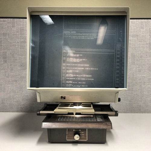
    I then took these sheets and walked over to a machine (shown below) where I could inspect the drawings. Everything about the machine had to be reversed. In order to get the drawings to show up properly, I had to put the microfiche sheets in upside down and mirrored left-to-right. 

    image

    As I looked through the sheets, I was then instructed to demarcate – with a post-it note – which drawings I wanted a copy of. At the end of it all, the lady filled out another form that would be sent to a printing shop who would then convert these microfiche drawings into PDF files for me. I think that will end up costing a few hundred dollars when it’s all said and done.

    However, at this point, I also learned that this procedure applied only to drawings, and not to any of the other documents that I was able to find on the microfiche sheets. For non-drawing documents, I actually had to file what’s called a Freedom of Information application at a separate counter upstairs. So I did that. I applied to free the information. It was only $5, but the turnaround time for that is 30 days.

    Now, I realize that we’re talking about old drawings and documents. Some of them were from the 1940s. But I’m a big believer in the value of open information. And so today was a good reminder to me that, even though we now have a tremendous amount of useful information at our fingertips, there’s still lots of valuable information that’s really difficult to get.