Daily insights for city builders, delivered every morning at 6 AM ET. I’m Brandon Donnelly — a Toronto-based real estate developer and founder of Globizen. I’ve been writing here since 2013.

Tag: atc

  • Why Canada needs a true urban agenda

    It should start from the premise that the fundamental underpinning of the Canadian economy to have prosperity is dependent on the success of the cities, because 80 per cent of Canadians live in cities.
    -Toronto mayor John Tory

    This week the leaders of Canada’s 22 largest municipalities are gathering in Toronto to figure out how to put urban issues on our national agenda. This is a topic I’ve touched upon many times before on Architect This City, but I continue to believe that it’s one of our most pressing issues.

    We know that the vast majority of Canadians live in cities (see above quote) and we know that the vast majority of our economic output is concentrated in cities. In fact, roughly half of Canada’s GDP is produced in our 6 biggest cities alone – Toronto, Montreal, Vancouver, Calgary, Edmonton, and Ottawa-Gatineau.

    But despite this concentration of wealth and economic activity, our governance structures do not reflect this reality. They’re outdated. They were built for a Canada that has passed. And so in my view, there’s a significant amount of untapped potential lying dormant in our cities if only we could get around to properly empowering them. There’s a “stimulus package” waiting to be unleashed.

    In anticipation of this week’s leadership meeting, the Globe and Mail published an article called, Canada’s big city mayors ready to push urban agenda. And in it they included a number of interviews with Canadian mayors. It’s fairly long, but definitely worth a read. Here are a few relevant sound bites…

    Vancouver mayor Gregor Robertson

    We have an archaic system. Cities aren’t recognized in our constitution. It’s unbelievable. But Big City Mayors have set aside those important gaps because the needs are now so urgent on housing and transit, we can’t afford to spend a couple years debating structural change. For the time being, the focus is just on ensuring there’s more federal capital provided for transit and other urban infrastructure.

    Calgary mayor Naheed Nenshi (on municipal funding sources)

    I would prefer to levy myself, so that I’m ultimately accountable to my citizens and, if they don’t like it, they can get rid of me. Allowing others to levy the tools takes away predictability and stability, as well. That said, we’re starving here, and any improvement to the system that leads to those predictable, stable cash flows is a good thing.

    Winnipeg mayor Brian Bowman (on the most pressing issue facing Canadian cities)

    I’d say without question infrastructure and new funding models to modernize the ways that cities fund themselves. That’s something I’ve started discussions on already with some of my counterparts, Mayor [Naheed] Nenshi in Calgary, Mayor [Don] Iveson in Edmonton as well as Gregor Robertson in Vancouver. We’ve talked about a number of topics including the missing and murdered indigenous women and girls issue, public transit and rapid transit development. But the one consistent theme is that the way cities are funded is outdated.

    Toronto mayor John Tory

    I start from this premise: Are people paying enough taxes? In many cases, you could argue, not only are they paying enough taxes, they can’t afford to pay any more. We should be looking at the total amounts paid to all three levels of government and how that is being allocated. Do we believe that, in the case of Toronto, the federal and provincial governments are making adequate investments in transit, given the amount of money they take out of this area in taxation? I would say the answer is: not yet. [But] they have been doing better.

    Montreal mayor Denis Coderre

    We are negotiating a new pact between the province and Montreal, and it’s all about municipal autonomy. We need tools so we’re not always waiting in the hallway at the end of legislative sessions looking for amendments to make the city work better. Since 85 per cent of immigration in Quebec is going to Montreal, we need more control over tools of integration, like job creation and housing. Montreal needs financial leverage…

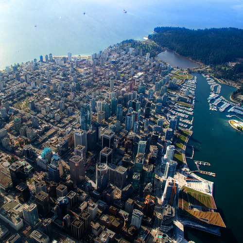
    Image: Vancouver via Flickr
  • A look at homeownership rates

    The Old Urbanist (Charlie Gardner) recently published an interesting post talking about the origins of American zoning using the work of Professor Sonia Hirt and her new book, Zoned in the USA: The Origins and Implications of American Land-Use Regulation.

    One of the central themes in his post is the American (and Canadian) fixation on single-family homes:

    …the United States is the only developed country of those surveyed, apart from Canada, to widely employ single-family detached residential zones that bar all commercial and multifamily uses.

    And the reason for this is largely because of two longstanding beliefs in American (and again Canadian) culture: Your goal should be to become a homeowner, and that home should ideally be a single-family detached home.

    But there’s lots of evidence to suggest that these legal protections (and many of the other things being done to encourage/subsidize homeownership) aren’t actually that effective at driving up homeownership.

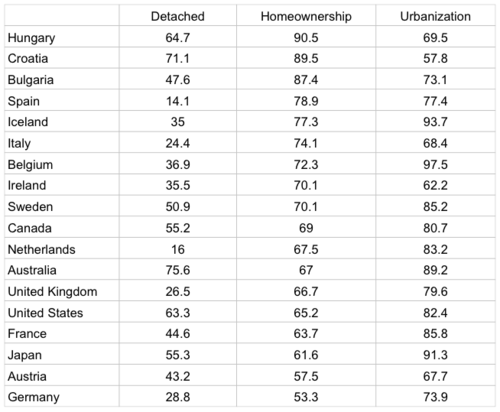
    In his post, Charlie includes a chart showing the percentage of detached homes and the homeownership rates for various countries (data is from 2013/2014). I sorted it based on homeownership and added urbanization rates to see if there was any correlation (doesn’t appear to be).

    Source: Charlie Gardner & Wikipedia

    The US and Canada are quite good at putting lots of people in detached housing (though not as good as Australia!), but the homeownership rates are nowhere near the top. In fact, the US falls in the lower half.

    Did you think the homeownership rate would be higher in the US?

  • A tale of two cities

    image

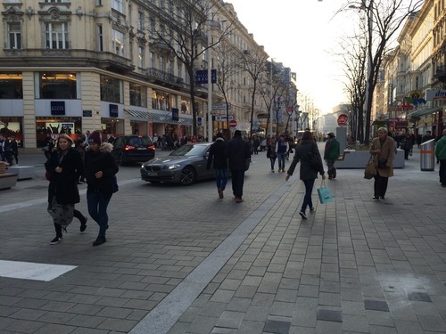
    Yesterday my friend Darren Davis out of Auckland introduced me to a 3-part blog series that he recently did with Andreas Lindinger out of Vienna, which looked at pedestrian zones and shared spaces across these two cities.

    The first post looks at the redesign of Vienna’s Mariahilferstraße (important shopping street that I’m somewhat glad I get to write and not try and pronounce). The second post looks at Auckland’s overall shared space program. And the third one offers a direct comparison between the two cities. The posts are all hosted on an interesting blog called Vienncouver (Vienna + Vancouver), which I am now following as of this morning.

    Compared to both Auckland and Vienna, Toronto is behind when it comes to pedestrian zones and shared spaces. So it’s interesting to see how other cities have managed to pull it off. It’s also further proof that you don’t have to be a warm climate city to have amazing public spaces.

    Image: Vienna via Vienncouver (notice the cars and pedestrians mixed in)

  • Nominate your laneway for transformation

    image

    Some of you might be aware that I’m involved with a non-profit group here in Toronto called The Laneway Project

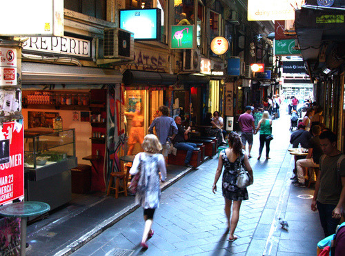
    Our mission is to transform the city’s under-utilized laneways into safe, vibrant, and people-friendly spaces – which is something that has been done with a lot of success in other parts of the world (see Melbourne above).

    Today I’m excited to announce two things.

    First, the group has received funding from the Ontario Trillium Foundation. This is great news because it’s obviously a lot easier to execute on a mission when you have some resources behind you.

    And that ties into the second announcement. 

    The funding received from the OTF is going to be used for 2 laneway transformation projects here in Toronto. Think of them as pilot projects that will help to reorient Torontonians into thinking about laneways as viable public spaces and to demonstrate that this group is about real action.

    Once the 2 laneways have been chosen, The Laneway Project will work with those local communities to come up with a vision and then an implementation plan. But before that can happen, there needs to be 2 laneways.

    So if you’re a community group, resident association, business improvement area, or some other passionate group, now is your chance to nominate your laneway. Get in touch with The Laneway Project before February 7th, 2015 by clicking here.

    Image: Melbourne Laneway via Flickr

  • Our fixation with height

    image

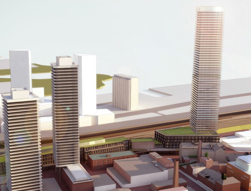
    Last summer a development application was submitted for a 57 storey mixed-use tower on the south end of Toronto’s historic Distillery District. 

    It’s the tower on the right hand side of the picture above. The 2 towers on the left are existing, although they’re quite recent. The development site is currently a parking lot and it abuts a railway corridor to the south.

    The reason I bring up this project now is because I recently saw this notice go out from the Gooderham & Worts Neighbourhood Association. It’s an announcement for a public meeting that I believe just happened earlier this week (I think they meant to say 2015 instead of 2014).

    After I saw the notice, I decided to share the rendering on social media to see what people thought of the proposal. The general consensus seemed to be that the tower looked a bit cookie cutter (though to be fair it’s hard to tell from renderings like this) and that 57 storeys was simply too tall for the area. I got comments back like “enough is enough.”

    Now, I’m not here to say that 57 storeys is exactly the right height for this building and this location (though it might be), but I am saying that I don’t think it’s as important as most people think it is. I think we’ve become over-fixated on height, at the expense of other important design issues.

    Part of this has to do with how we communicate projects and how we tell the story. If you look at the city’s website for this project, you’ll see that this is how it’s explained:

    The City has received an Official Plan Amendment and Rezoning application for a 57-storey mixed use tower and a 5-storey commercial building containing 496 residential dwellings, 5,048 square metres of retail gross floor area, and 21,243 square metres of office gross floor area. The 5-storey commercial building is within the Distillery District, and the 57 storey tower is immediately south west of the Distillery District.

    About the only thing that I think most people (outside of the industry) would understand are the heights of the buildings. Everything else – from the Official Plan Amendment to the number of square metres of gross retail area – is likely lost. 

    So it’s actually not surprising that most people just look at one or two renderings and the number of storeys, and then make a judgement call about whether or not it would be a positive thing for the city.

    Now, I know why we communicate projects in such a clinical way. It’s to appear impartial. But there are so many other considerations when it comes to great city building. 

    How does the building meet the street? What are the first couple of floors like at eye-level? What’s the materiality? What would the experience be like for someone having a coffee on a patio outside of the building? What kind of commercial tenants will there be? Is there a unique leasing/programming strategy? What’s the overall vision for the project?

    Again, I’m not saying that height is completely irrelevant. I simply fear that we might be losing sight of the bigger picture. The Distillery District is a magical place in Toronto. It’s hands down one of my favorite places to be. In fact, I’ll be there this weekend for a Winterlicious dinner. But I honestly couldn’t tell you how tall the existing towers are. Are they in the 40s? 

    I could, however, tell you exactly what it’s like to walk down the Distillery’s intimate cobblestone streets and sit on a patio with a beer in hand. It’s a beautiful thing.

    Note: I have zero affiliation with this project.

    Image: City of Toronto

  • An example of low-rise intensification: Union Street EcoHeritage

    image

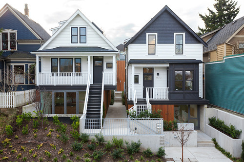
    In yesterday’s post about the 3 stages of intensification, I mentioned a project in Vancouver called Union Street EcoHeritage by SHAPE Architecture. I used it as an example for sensitive low-rise intensification.

    Since it’s a very cool project (and most of you probably didn’t click through), I thought I would dedicate today’s post to explaining the project.

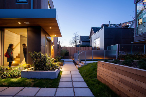
    The picture at the top of this post is what it looks like today (the front elevation). If you were to pass by it, I suspect most of you would just think it was a pair of renovated single family homes. But there’s much more to it. What started out as only 2 dwellings, ended up as a site for 7 dwellings.

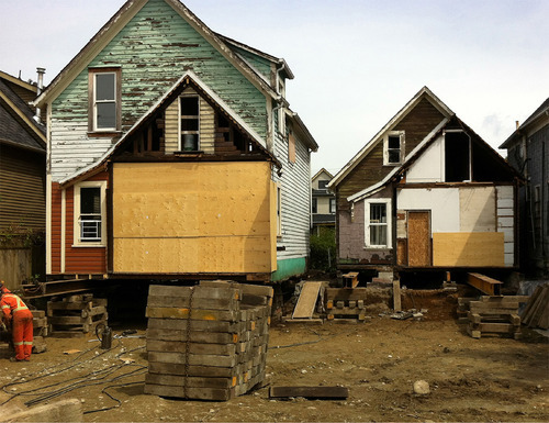
    Here’s the before shot:

    image

    The homes were moved and actually raised up in order to accommodate additional density. Here’s a section that better explains what was done (black is existing; green is new):

    image

    The 2 existing homes were raised up so that an additional dwelling unit could be placed beneath each one. At the same time, additional units were added in the rear, both attached to the existing homes and at the back of the site facing the laneway. And so this project is actually one part laneway house.

    Here’s a photo of what that rear interior space looks like (it’s stunning):

    image

    Not surprisingly, this project won a bunch of awards and has been widely celebrated as an affordable housing solution. It’s exciting to see Vancouver take the lead on low-rise intensification. It’s one of the reasons that I think it’s only a matter of time before Toronto starts to look towards similar solutions.

    Images: SHAPE Architecture Inc.

  • 3 stages of intensification

    image

    We all know that the Greater Toronto Area is growing and intensifying at an incredible pace. In fact, last year the region set a record with 25,571 new condominium units completed.

    If you listen to industry experts, such as George Carras of RealNet, they’ll tell you that this level of intensification — which usually means condominiums — is really a decade in the making. That’s when the government set out to explicitly encourage this type of growth.

    But in the decade since that decision, we’ve seen both government and the market evolve in terms of what that intensification should look like. It started out with a largely high-rise building typology. Tall buildings were to be allowed in the downtown, as well as in specific growth nodes throughout the region. But for everything in between — the officially designated “neighborhoods” — there was to be no development.

    This is what I’ll call the first stage of intensification.

    Then, we started to think about mid-rise intensification along the avenues. Most of these “avenues” (also an official term) cut through those same stable neighborhoods, but the main streets were seen as an appropriate place to allow additional growth. It makes perfect sense and so guidelines were created to help dictate what this new building typology should look like.

    This is what I’ll call the second stage of intensification.

    And it’s one that I’d argue we’re currently living through with new mid-rise projects like DUKE in the Junction (TAS project), Kingston&Co in Kingston Road Village (another TAS project), Abacus Lofts on Dundas West, and The Hive in Etobicoke. These are all mid-rise buildings going up in established neighborhoods.

    With the recent decision to also allow wood frame buildings up to 6 storeys in Ontario (instead of 4), we’ll probably see an even greater surge in mid-rise buildings once the private sector gets its head around this shift.

    So what’s next?

    I think it’s inevitable that we’ll eventually see low-rise intensification within our established neighborhoods. We started by avoiding them altogether, and then deciding that it was desirable to build along their periphery. But as demand for urban housing continues to increase, I believe it’s only a matter of time before we start to loosen the reins on our single family neighborhoods.

    Some of you might be thinking that this is going to be a bad thing, but I actually think the opposite. Projects such as Vancouver’s Union Street EcoHeritage prove that it’s entirely possible to intensify existing neighborhoods through sensitive and beautiful infill interventions. And of course, let’s not forget about laneway housing.

    The fact of the matter is that Toronto has already been intensifying its neighborhoods for a very long time — likely since the beginning — by converting single family homes into duplexes, triplexes, and other multi-family dwellings. We just haven’t been doing it in any sort of structured way.

    I don’t know when this will change, but I think it’s only a matter of time. And that will be the third stage of intensification.

    Image: Flickr

  • The hard things about retail

    image

    Retail is one of the hardest – if not the hardest – real estate category to get right. If you don’t have the right setup, the right location, and the right tenant mix, you can fail pretty easily. It’s a bit of an art. And that obviously applies to both landlords and tenants. I mean, we all know what recently happened with Target Canada.

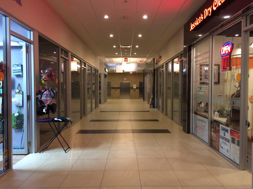
    This past weekend I had the opportunity to visit the Aura Condos in Toronto, which is supposedly the tallest and largest residential condominium in Canada. There’s about 1.1 million square feet of residential space across 79 floors and somewhere around 150,000 to 180,000 square feet of retail space (the estimates I found online varied). The main anchors include Bed Bath & Beyond, Marshalls, and Hard Candy Fitness (which also serves as the gym for the residences above).

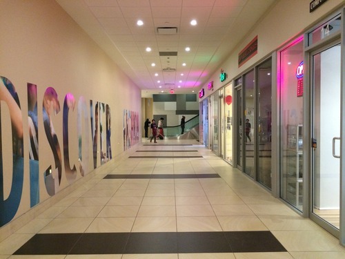
    But what’s probably most unique about the retail component of this building is the P1 level (the first underground level). It’s made up of small retail condos, some of which looked to be about 90 square feet. That means that each retail unit is individually owned, just like a residential condominium, and there’s no singular landlord focused on curating the tenant mix and ensuring the entire retail center does well.

    Now, I’m told that this approach works perfectly well in other parts of the world and I know that we’re trying it in other parts of the Greater Toronto Area, but I worry about the long term viability of this (P1) space in particular. When I was there on Saturday there was almost no foot traffic and probably half of the retail units were vacant.

    Maybe it’s because there isn’t enough employment density in the area. Maybe it’s because it’s not well connected to other P1 level retail. Or maybe it’s because the anchors all sit above this space, as opposed to around it (as they do in traditional malls). Whatever it is, I wasn’t feeling product/market fit.

    I hope I’m wrong.

    Images: P1 Retail at Aura Condos

  • The Monocle Quality of Life Conference

    image

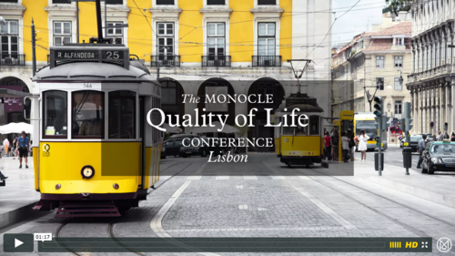
    Monocle magazine is launching their first ever conference this spring in Lisbon and it’s dedicated to quality life in the world’s greatest cities. It’s going to take place Friday, April 17th to Saturday, April 18th, 2015.

    You can click the image above for a video synopsis (there’s great urban eye candy), but if you don’t feel like doing that, here’s the text version:

    MONOCLE invites you to a weekend of peerless hospitality, great debates and in-depth conversations about the forces shaping the world’s great cities. Join our editors, correspondents and key thinkers in discussing topics ranging from architecture to independent retail, city planning to national branding.

    It sounds like a wonderful event and very much inline with some of the topics discussed here on Architect This City. If I had a conference budget that needed to get spent, I would be the first to sign up. If you’re interested, you can “register your interest” by clicking here. Tickets are €1,500.

  • How I moved over the last 3 weeks

    At the beginning of this year I wrote a post about a mobile tracking app called Moves that I had heard about through my friend Sachin Monga. He had just published a beautiful set maps showing where he physically spent his time in both Toronto and San Francisco.

    His post spurred me to download the app and at the end of my post I promised to share my own set of maps once I had collected enough data points. It’s only been about 3 weeks, but already my maps are starting to fill out, so I thought I would do a release.

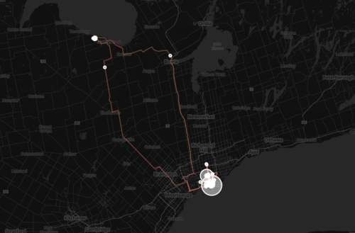
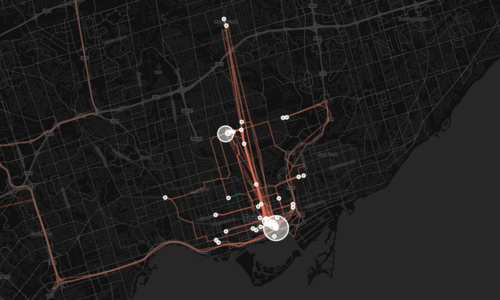
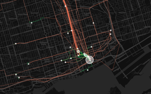
    The orange lines represent transport of some sort (car, subway, streetcar, and so on) and the green lines represent walking. I don’t cycle very often in the winter (I know, I’m a fair-weather cyclist), so you won’t see any of those lines just yet. However if I posted a map from the summer, I know it would look completely different.

    Here’s a first one showing a regional scale:

    image

    Here’s a second one showing the city of Toronto:

    image

    And here’s a third one showing mostly downtown:

    image

    What’s interesting about these maps is how much you can tell about me and the way I move around the city.

    For one, there’s a good chance I ski or snowboard given that I’m driving up to Collingwood, Ontario in the winter. You can also see how heavily dependent I am on the Yonge subway line, which is the thickest orange line in the middle of downtown. It’s also interesting to see how localized I am within my neighborhood (St. Lawrence Market). I walk to get groceries. I walk to the gym. I walk to coffee. And the list goes on.

    This is fairly typical for people living in urban neighborhoods, but it would be interesting to see where it applies in the city and where it begins to fall apart. I would also imagine that there’s a correlation to the area’s Walk Score, although this (Moves) might actually be a better measure since it’s usage data.

    Either way, imagine what cities could do if they had this sort of data for every resident. They would be able to see precise resident flows and then determine exactly where transit and infrastructure investments should be made instead of politicking to determine where they should be made.

    That time is coming.