Daily insights for city builders, delivered every morning at 6 AM ET. I’m Brandon Donnelly — a Toronto-based real estate developer and founder of Globizen. I’ve been writing here since 2013.

  • SoCal Googie

    I must have been sick for this lesson in architecture school, because I just discovered, through Curbed, that there is a subset of mid-century modern architecture known as Googie. It originated in Southern California in the 1940s and was all about the future, car culture, the Space Age, and the many other things that dominated the postwar years. Think starbursts, curvaceous geometric shapes, and bright colors. We all know the architecture. But did you know it was called, Googie?

    Supposedly the Googie movement was given its label by architecture critic Douglas Haskell, who used it in a derogatory way to describe criticize the architectural fashion at the time. Googie was the name of an actual coffee shop in West Hollywood designed by John Lautner. And that’s something that is noteworthy about Googie. It was a form of architecture for average buildings: coffee shops, gas stations, motels, and those sorts of things.

    There will always be critics who eschew that which is fashionable at the time. I suppose one could argue that if you’re being fashionable, then you’re not being timeless. Because fashion is about what’s current. And good architecture should be timeless, right? But there’s something so fascinating about a kind of built form that perfectly captures a particular time and place. Middle of the 20th century. Car-oriented Southern California. 

    Sometimes good architecture and design also needs a bit of time and distance in order to fully appreciate it. What was once garish may one day become treasured. Just give it a generation or two.

    Photo by ian dooley on Unsplash
  • 2720 Dundas Street West

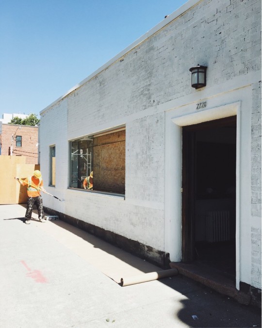
    If you’ve been in the Junction lately, you have probably noticed some activity at the location of our proposed Junction House. Here is a photo that I took this morning of 2720 Dundas Street West. (Sidebar: What an absolutely gorgeous summer day in Toronto.)

    image

    We’re giving the front a coat of fresh white to mark the beginning of the registration phase. Pretty soon you’ll be able to leave your name with us so that we can send you insightful emails and get in touch with you when condo sales begin. 

    At some point 2720 will become home to the Junction House sales office (maybe we’ll even call it something pretentious like a presentation gallery). But that point is not right now. 

    I can, however, tell you that in addition to superkül (architecture), we are working with Paul Johnston / Unique Urban Homes (sales), Dialogue 38 (interior design), and Vanderbrand (creative agency). 

    I am also personally spending a lot of time obsessing over kitchen details and other minutia. I think Charles Eames once said, “The details are not the details. They make the design.”

    If you’d like to be kept in the loop on Junction House, you can follow Slate Developments (nascent account), the Globizen Group, and myself on Instagram. And of course, you’ll also hear all about it on the blog. Have a great weekend friends.

  • Car-dependent spatial structure

    Earlier this week a 58 year old woman named Dalia was struck and killed by a car near the University of Toronto’s downtown campus. This tragedy has everyone talking about and questioning how to make our roads safer, though the answers are not difficult to find. Here is an excerpt from a piece that Richard Florida penned following the incident called, Toronto’s Deadly Car Crisis:

    Today, more Torontonians die from being hit by cars than from being killed by guns. In 2016, nearly 2,000 pedestrians and 1,000 cyclists in the city were hit by cars. Of these, 43 resulted in fatalities. On average, a pedestrian in Toronto is hit every four or five hours, and a cyclist every eight or nine. This means that Toronto’s rate of pedestrian deaths was 1.6 per 100,000 people in 2016 — worse than in Chicago, Seattle, San Francisco, Boston, Washington, D.C., Portland, Pittsburgh, Cleveland, and Buffalo. It has risen to 1.7 deaths per 100,000 people in 2017 and is on track to rise still further to 1.8 deaths per 100,000 this year. And, children and the elderly face the greatest risk of being struck and killed by a car. The problem is only getting worse. Across Canada, pedestrian fatalities increased by more than 10 percent between 2010 and 2016; at time when they decreased by more than 25 percent in European countries like Norway, Switzerland, and the Netherlands.

    The broader issue is what he refers to as Toronto’s “car-dependent spatial structure.” And it is detrimental to not only our public safety, as we saw this week, but also to our ability to grow as a global city. The Greater Toronto Area is projected to reach 10 million people by 2041. I agree with Florida that, for a number of important reasons, we are going to need to commit ourselves to a new model for growth.

  • What to do about Hong Kong’s land supply problem?

    My friend Jeremiah shared this ULI article with me this morning, which talks about Hong Kong’s land supply problem. The interesting thing about this problem is that only 9.3 square miles of the city’s land (out of ~424 square miles) is actually developed (and about 60% of the region’s area is water). The rest has been preserved for parks, farmland, and so on. And that is certainly a remarkable characteristic of Hong Kong. It doesn’t take very long to escape its hyper-urbanism and be in the countryside.

    Preserving greenspace is of course vital. But at what point do population and growth pressures justify the unlocking of some of that land for development? This is the question that Hong Kong appears to be asking itself. At the same time, it is looking at developing other islands (such as Lantau, which I understand is a pretty lush place); reclaiming (i.e. creating) additional land; and positioning the city as part of a planned “Greater Bay Area.” 

    If it were up to you, how would you suggest that Hong Kong deal with these pressures? The city is already fairly adept at building up.

    Photo by Annie Spratt on Unsplash

  • The Korean Peninsula

    I just spent the last 7 minutes listening to this brief historical overview of Seoul by The Urbanist, while I bounced around the city on Google Street View, admiring the coverage of their transit network and the density of their low-rise neighborhoods. 

    I love Street View and I love using it to explore cities.

    One of the things I liked about The Urbanist episode –  beyond it being a good soundtrack while I explored – is that it talks, albeit briefly, about why Seoul is located where it is today. 

    I am always curious about this when it comes to cities. I mean, who was it that decided, yup, this is going to be the spot. Because it’s generally a pretty sticky decision once it is made.

    You may also find this 2014 NASA photograph of the Korean Peninsula interesting. The nighttime sky renders up a pretty stark contrast between North Korea and South Korea.

    According to NASA, per capita power consumption in North Korea and South Korea is 739 kilowatt hours and 10,161 kilowatt hours, respectively. That’s why the satellite photo looks the way it does.

  • Doing stuff vs. owning stuff

    “People get income for doing stuff, and they get income for owning stuff. Increasingly the latter. And the ownership share of income goes to a small slice of households that own almost all the stuff.”

    This is a quote from a recent article by Steve Roth over at Evonomics, where he breaks down the share of US household income that is derived from “labor” vs. “capital.” In other words, how much money do households make from working (trading their time for money) and how much do they make from their existing wealth (that is, owning stuff)?

    If I were to oversimplify how he calculates this (you can read all of the details, here), it is: (Income – Labor Compensation) / Income. Take all of the household income. Subtract the money made from doing stuff. And then divide it by total income to get the percentage made from “unearned property income.” There are gray areas and others things to consider, but that’s the gist of it.

    What he discovers and argues is that basically 50% of household income comes from simply being wealthy and owning stuff. He also reminds us that approximately 60% of US wealth is… “earned the old-fashioned away: it’s inherited.”

  • An example of city building doublethink

    Earlier this month, Shane Dingman wrote a piece in the Globe and Mail talking about TAS’ proposed development for 2 Tecumseth Avenue here in Toronto – the former home of Quality Meat Packers, a slaughterhouse. In the article there’s a quote from Mazyar Mortazavi, which I posted to my Instagram (as a story), but that I have been meaning to also post to the blog. So here it is: 

    “It’s not a conversation about towers good, towers bad: Mid-rise is the most expensive construction typology and it delivers effectively luxury housing, so it doesn’t respond to the needs of affordability,” he said. “We didn’t buy Tecumseth to build a bunch of condos and move on. We bought it because we wanted to pursue a vision around city building. You need density … the question is how do we actually deliver density that’s relevant today and relevant 50 years from now?”

    He’s of course right about mid-rise construction costs. There are diseconomies of scale and other construction inefficiencies that we have talked about many times before on this blog. The result is one of the Catch-22s of city building. Mid-rise and small scale infill is often seen as desirable, but we also say that we need more affordable housing.

    It’s doublethink.

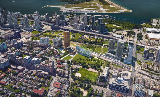
    Image: 2 Tecumseth by KPMB Architects for TAS

  • Shift toward the center

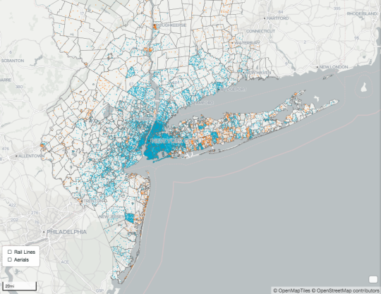
    The New York City Department of City Planning has a very cool “metro region explorer” online that allows you to explore population, housing, and employment trends in the tri-state NYC Metropolitan Region. Start here and then click on “Learn More” to cycle through the slides and data.

    One interesting takeaway is that population growth continues to centralize in the region’s core. Since 2010, 60% of the region’s population growth has taken place in the five boroughs of New York City, and in particular it has occurred in neighborhoods with strong rail transit.

    There has also been a slowing in terms of the number of residents leaving New York City. Historically, people moved to the city in their 20′s and left in their 30′s. That trend is slowing.

    I suspect this has to do with a combination of factors, including the shift toward a city-centered knowledge economy; the desire for walkability and urban amenities; the phenomenon of people getting married later in life (if at all); and so on.

    The people who do leave the city are also more likely to leave for other parts of the U.S. than other parts of the region. This has led to a decline in the number of prime age (25-54 years old) workers in the suburbs.

    Check out the Metro Region Explorer, here. There’s a lot of good stuff in there.

  • DANCHI DREAMS

    Below is an interesting Kickstarter project by photographer and art director Cody Ellingham. I think many of you will appreciate it. It is a photobook of Japanese public housing apartments, which are known as Danchi. All of the photos were taken by Cory at night, hence the dream part. The book is about the promise that these projects represented in the post-war years, but it is also about their decline in the subsequent decades.

    https://www.kickstarter.com/projects/cbje/danchi-dreams-a-photobook-of-japanese-public-housi/widget/video.html

  • City building reading list (and an event)

    Today’s post is going to be about a handful of things that have caught my attention.

    – Gary Hack, who is the former dean of the University of Pennsylvania School of Design, recently published a book called Site Planning: International Practice. It is a textbookish guide to planning processes, new technologies, and sustainability, with an emphasis on rapidly urbanizing countries. Thank you to my friend Michael Geller for bringing this to my attention.

    – Sidewalk Labs Toronto is opening a new experimental workspace here in Toronto at 307 Lake Shore Boulevard East (Queens Quay & Parliament) on Saturday, June 16th from 12 – 6pm. It’s an old fish processing plant that they have turned into their office. The team will work there during the week and on the weekends they will open to the public to showcase what they’re up to. Register for the June 16th event, here. I just did.

    – Alexandra Lange has a recent piece in the New Yorker called, The Hidden Women of Architecture and Design. It’s about the important role that women have played in the “design of childhood”, which is the title of a book by Lange. There’s also a short but interesting story about Detroit’s Lafayette Park (Mies van der Rohe) at the beginning of the article.

    – Finally, here is a blog post by Witold Rybczynski where he talks about the shortcomings of architectural education. Obscure theories. Technical or made-up jargon. And no concern for budgets and schedules. I have always shared a similar view and have long felt that there needs to be more business school in architecture school.

    Hopefully there’s something in here that is of interest to you.