On this blog, we often talk about city building in the context of doing things to help improve a city -- whether that be a development project, a new public art mural, or an interesting local business. These interventions help to build a city. But even more specifically, the term has, for many, come to mean building up a city in a positive way.
But there is another way to think about city building. You can think of it in terms of building actual new cities. We've spoken about some of these before, namely this one in California and this odd one in Saudi Arabia. But apparently it is becoming more common. According to The Economist, the world is now building more new cities than it has in the last 80 or so years:
Egypt’s “New Administrative Capital” is part of a rush of city-building. Firms and governments are planning more settlements than at any time in the post-war period, with many already under construction. Ninety-one cities have been announced in the past decade, with 15 in the past year alone. In addition to its new capital in the north, Egypt is building five other cities, with plans for dozens more. India is considering eight urban hubs. Outside Baghdad, Iraq, workers have just broken ground on the first of five settlements.
So I guess I was wrong. I thought "The Line" in Saudia Arabia was never going to be built -- at least not in its current incarnation. But apparently it is now under construction, and it is still planned to be 170 km long and house some 9 million people when it's complete. I suppose something could happen between now and when all 170 km are complete, but I'm happy to accept that, for the time being, I was wrong.
Now it's time to ask ourselves what a 170 km long city would even be like. To answer that, here is a fascinating article from npc Urban Sustainability describing how mobility and urban interactions are likely to work in this kind of a linear city. And it turns out that a line is actually an optimal urban form if you're trying to both maximize commute times and maximize the average distance between inhabitants:
One of the most critical aspects related to The Line is distance. If its 9 million inhabitants are homogeneously distributed in the city, each km will have roughly 53,000 people. If we randomly pick two people from the city, they will be, on average, 57 km apart. Although The Line occupies only 2% of the surface of Johannesburg, if we pick two random people in Johannesburg, they are only 33 km apart.
Brandon Donnelly
Daily insights for city builders. Published since 2013 by Toronto-based real estate developer Brandon Donnelly.
I like and agree with this tweet: "You can have bad urbanism with good architecture, and good urbanism with bad architecture." The two provided examples of this are (1) Brasilia and (2) what appears to be some random little street in Japan.
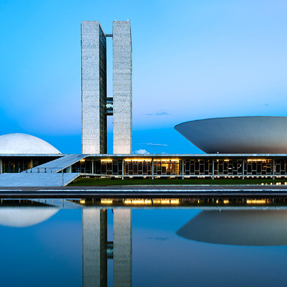
Brasilia is the capital of Brazil. It's a masterplanned city designed by Lúcio Costa, Oscar Niemeyer and Joaquim Cardozo in the 1950s. And it was all part of a plan to move the capital from Rio de Janeiro to a more central location in the middle of the country.
The result is some incredible architecture by Oscar Niemeyer that, for me, is emblematic of the country. Brazil was one of the first countries outside of Europe to adopt modern architecture and it's precisely for this reason that Brasilia is high on my list of places to visit. (Rio is also one of my favorite cities.)
But whenever I tell a Brazilian that I want to visit the city, the usual response is, “Why?” I then have to explain that it’s because of Niemeyer and the architecture, and then they say, “Oh, okay, that makes sense. But besides the architecture, there isn’t much else to see or do there.”
Part of the reason for this could be because the city has objectively bad urbanism. When you look at it in plan view, the layout of the city resembles a plane or bird in flight, and that is, I guess, symbolically cool when you view it on Google Maps. But on the ground, cities are not at their best when they're designed around abstract symbols.
They're at their best when they're designed around people. And this is what example number two does well. The architecture is ugly and nondescript, but the street is narrow, the road is shared, and the buildings contain a mix of fine-grained uses.
In some cases, it is being done as a solution to urban congestion. If this city is too expensive and unaffordable, just create a new one. This appears to be part of the idea with the above city outside of San Francisco. Of course, new cities can also be created for ideological reasons, or for political purposes, which was the case with Brazil's capital city, Brasilia.
Here, the idea was to move the federal capital away from the country's populated southeast region to a more geographically neutral location in the middle of the country. It also turns out that seeding a new city with government institutions is a good way to get one of these started. Existing cities do, after all, benefit from network effects.
History points to characteristics shared by successful projects. State institutions can help anchor cities, as Brasília (in Brazil) and Chandigarh (in India) showed in the 20th century. Although both have had problems, people in Brazil and India are voting with their feet. Brasília’s population is growing at 1.2% a year, more than double the national average. Chandigarh, a state capital, is now India’s fourth-richest region on a per-person basis.
But putting money, ego, and ideology aside, when does it actually make sense to start a new city in lieu of just expanding (or addressing the problems in) the one(s) you've already got? Population size can't be the only factor in determining whether a city is "full", because Tokyo seems to do just fine as the largest metropolitan area in the world.
If it hasn't already been done, I think this would make for an interesting research project. Until then, there's this (paywalled) Economist article.
Keeping the surface fixed, a line is the contiguous urban form that maximises the distance between its inhabitants.
In The Line, people are as far away from others as possible. Considering that a walkable distance is 1.0 km, in The Line, only 1.2% of the population is at walking distance from others. Active mobility is not viable in The Line since distances are too long. The plan for The Line has no cars but also gets rid of most active mobility. Although in The Line, basic needs could be satisfied within 5 min, most journeys to school, work, leisure or visiting other people will depend on public transport.
So what would be better? Well if you're trying to minimize the average distance between people and increase urban interactions, then the optimal form is generally the one that cities have been using ever since they were first created:
We can think of a city called The Circle, where we take the same tall buildings as in The Line but put them next to each other, forming a circular shape. A circle that occupies the same surface as The Line (34 km2) has a radius of only 3.3 km. In The Circle, the expected distance between two random people is only 2.9 km. In The Circle, a person is at a walking distance of 24% of the population (and within 2 km, they could reach 66% of the destinations), so most of their mobility could be active. In The Circle, a high-speed rail system is unnecessary since people could walk or cycle to most places, and buses could supply the rest of the journeys. The Circle occupies roughly the same surface as Pisa, Italy, but has 50 times its population. A round urban form is the most desirable since it reduces commuting distances and the energy required for transport.
This is one of the challenges with building large scale cities from scratch. It's easy to become enamoured with a particular plan or symbol; whereas in reality, cities don't care about these kinds of visual representations. They don't care that, in plan, the city may look like an eagle (see "Helicopter Urbanism", a term that was supposedly coined by Jan Gehl). What matters is how interactions between humans play out at street level.
I like and agree with this tweet: "You can have bad urbanism with good architecture, and good urbanism with bad architecture." The two provided examples of this are (1) Brasilia and (2) what appears to be some random little street in Japan.
Brasilia is the capital of Brazil. It's a masterplanned city designed by Lúcio Costa, Oscar Niemeyer and Joaquim Cardozo in the 1950s. And it was all part of a plan to move the capital from Rio de Janeiro to a more central location in the middle of the country.
The result is some incredible architecture by Oscar Niemeyer that, for me, is emblematic of the country. Brazil was one of the first countries outside of Europe to adopt modern architecture and it's precisely for this reason that Brasilia is high on my list of places to visit. (Rio is also one of my favorite cities.)
But whenever I tell a Brazilian that I want to visit the city, the usual response is, “Why?” I then have to explain that it’s because of Niemeyer and the architecture, and then they say, “Oh, okay, that makes sense. But besides the architecture, there isn’t much else to see or do there.”
Part of the reason for this could be because the city has objectively bad urbanism. When you look at it in plan view, the layout of the city resembles a plane or bird in flight, and that is, I guess, symbolically cool when you view it on Google Maps. But on the ground, cities are not at their best when they're designed around abstract symbols.
They're at their best when they're designed around people. And this is what example number two does well. The architecture is ugly and nondescript, but the street is narrow, the road is shared, and the buildings contain a mix of fine-grained uses.
In some cases, it is being done as a solution to urban congestion. If this city is too expensive and unaffordable, just create a new one. This appears to be part of the idea with the above city outside of San Francisco. Of course, new cities can also be created for ideological reasons, or for political purposes, which was the case with Brazil's capital city, Brasilia.
Here, the idea was to move the federal capital away from the country's populated southeast region to a more geographically neutral location in the middle of the country. It also turns out that seeding a new city with government institutions is a good way to get one of these started. Existing cities do, after all, benefit from network effects.
History points to characteristics shared by successful projects. State institutions can help anchor cities, as Brasília (in Brazil) and Chandigarh (in India) showed in the 20th century. Although both have had problems, people in Brazil and India are voting with their feet. Brasília’s population is growing at 1.2% a year, more than double the national average. Chandigarh, a state capital, is now India’s fourth-richest region on a per-person basis.
But putting money, ego, and ideology aside, when does it actually make sense to start a new city in lieu of just expanding (or addressing the problems in) the one(s) you've already got? Population size can't be the only factor in determining whether a city is "full", because Tokyo seems to do just fine as the largest metropolitan area in the world.
If it hasn't already been done, I think this would make for an interesting research project. Until then, there's this (paywalled) Economist article.
Keeping the surface fixed, a line is the contiguous urban form that maximises the distance between its inhabitants.
In The Line, people are as far away from others as possible. Considering that a walkable distance is 1.0 km, in The Line, only 1.2% of the population is at walking distance from others. Active mobility is not viable in The Line since distances are too long. The plan for The Line has no cars but also gets rid of most active mobility. Although in The Line, basic needs could be satisfied within 5 min, most journeys to school, work, leisure or visiting other people will depend on public transport.
So what would be better? Well if you're trying to minimize the average distance between people and increase urban interactions, then the optimal form is generally the one that cities have been using ever since they were first created:
We can think of a city called The Circle, where we take the same tall buildings as in The Line but put them next to each other, forming a circular shape. A circle that occupies the same surface as The Line (34 km2) has a radius of only 3.3 km. In The Circle, the expected distance between two random people is only 2.9 km. In The Circle, a person is at a walking distance of 24% of the population (and within 2 km, they could reach 66% of the destinations), so most of their mobility could be active. In The Circle, a high-speed rail system is unnecessary since people could walk or cycle to most places, and buses could supply the rest of the journeys. The Circle occupies roughly the same surface as Pisa, Italy, but has 50 times its population. A round urban form is the most desirable since it reduces commuting distances and the energy required for transport.
This is one of the challenges with building large scale cities from scratch. It's easy to become enamoured with a particular plan or symbol; whereas in reality, cities don't care about these kinds of visual representations. They don't care that, in plan, the city may look like an eagle (see "Helicopter Urbanism", a term that was supposedly coined by Jan Gehl). What matters is how interactions between humans play out at street level.