Daily insights for city builders, delivered every morning at 6 AM ET. I’m Brandon Donnelly — a Toronto-based real estate developer and founder of Globizen. I’ve been writing here since 2013.

Tag: water

  • 🏊‍♂️ Le Plongeoir

    This beach area was closed because of high winds and choppy waters. But that didn’t stop these kids from doing some very impressive dives off of this ledge. It also happens to be right beside a wonderful restaurant / diving facility called Le Plongeoir.

  • New York City is testing new “flex gates”

    I spent a good chunk of this morning talking and thinking about underground building details that most people (unless you’re in the industry) would never think to consider. This is not a criticism on most people. I mean, I don’t know how iPhones are made. I just use and enjoy them. But when it comes to buildings, I’m paid to ask questions and understand how things work.

    There’s a lot of risk in the ground.

    You have to think about things like bearing capacity, environmental contamination (usually), hydrostatic pressure and, generally, how you’re going to manage water, particularly if you have a high groundwater table. Usually this last one is about making sure you’re keeping the water out. A pretty important detail both below and above grade.

    So when I came home tonight and saw the below tweet, I felt obligated to write about it.

    If you read the reply from NYC’s Metropolitan Transportation Authority, you’ll see that this is them testing something they call a “flex gate.” It is a flood barrier that allows them to seal off subway entrances in the case of a storm surge and they run these tests (shown above) for 4 hours at a time to make sure they’re installed property. This one was.

    Managing water is a big part of city building. New York City, Miami, Venice, and countless others know this all too well right now.

  • Out of office: Malaga

    The above photo was taken on a walk up to the Castillo de Gibralfaro in Malaga, Spain. It was built by the Moors during their occupation of the Iberian Peninsula in the Middle Ages.

    It is located on Mount Gibralfaro (~130m up) in the center of the city, overlooking the historic core, the waterfront, and its lower elevation sibling — the Alcazaba (or citadel).

    In the Middle Ages, this is what it meant for a city to be defensible. High ground. Formidable double walls. And places to shoot from.

    Thankfully, today, I think one could easily argue that “urban defensibility” tends to instead rely on things like knowledge, innovation, and diversity.

    Here are a couple of photos from inside the fortress. It is always amazing to see what labor was able to build without the technologies that we have today.

    Portions of it were built using a very elegant and elongated brick. Above is the bar area at the top. Presumably this was a later addition, though, supposedly the Moors did make and sell wine from the Andalucia region.

    If you ever find yourself in Malaga, this complex is a must visit.

  • Living on water

    Phaidon has a new architectural book out that surveys 55 homes, all of which have some sort of connection to water, whether that be an ocean, lake, river, or pool. It’s called Living on Water. I don’t (yet) have a copy, but it looks like the perfect coffee table book for a cottage, summer home, or studio apartment with zero connection to water. Monocle on Design recently interviewed the editor of the book (podcast episode here). So if beautiful homes on the water are your thing, maybe check it, and the book, out.

  • Don’t touch the walls

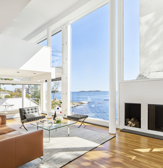
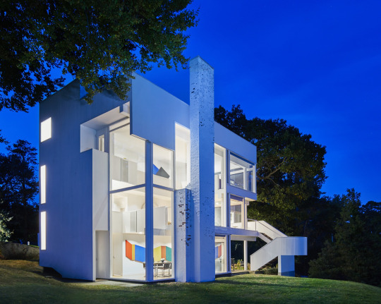
    The Smith House by Richard Meier turned 50 years old last year. In celebration of that, photographer Mike Schwartz took these photographs. And just recently they were published in Surface Magazine along with an interview of both Meier and Chuck Smith. Smith’s mother commissioned the house (completed in 1967) and he was 8 years old when the family moved in.

    My favorite comment in the article is this one by Smith:

    “Don’t throw balls in the house, and don’t touch the walls.” I must have heard “don’t touch the walls” three or four times a day. That said, there’s a crack in one of the windows where I shot it with a BB gun. We got away with some things.

    Modern architecture was supposed to be a perfectly engineered machine for living. But I guess living didn’t include touching the walls or shooting BB guns in the house.

    My favorite photos – both from Mike Schwartz – are these two:

    imageimage

    They feel like inversions of each other. The first one (day shot) is all about the views outward. Meier also talks about how the white on white helps to enhance this experience. The second one (night shot) turns the house inward on itself. Smith talks about how at night the view disappears and all you’re left with is your own reflection.

    I also like how the paint is flaking on the fireplace, which by the way, is perfectly on axis with the home’s entry. It makes you work a little bit for the view. Apparently keeping the paint on was a problem since day one. But it gives the house – which is otherwise seemingly perfect – a bit of a patina. 

    However, I’m guessing that Meier would prefer the paint stay on.

  • Hybrid 1-2-3

    For those of you who have been reading this blog since last summer, you’ll know that I’m particularly passionate about the Gardiner Expressway East here in Toronto.

    Last night a public meeting was held to discuss the 3 alternative designs for what has become known as the “hybrid” option. If you’d like a visual summary of the options, click here.

    But essentially as you go from hybrid 1 to hybrid 3, the elevated Gardiner Expressway just gets pushed further north, away from the water. So as you go from 1 to 3, the hybrid option becomes less offensive to the waterfront and its associated public realm, and it opens up more land for development. However, it also becomes more expensive.

    Here’s a graphical summary of the costs, which my friend Gil Meslin tweeted out last night:

    //platform.twitter.com/widgets.js

    Notice that the boulevard (remove) option, which City Council rejected last summer, remains by far the most cost effective option. At a time when the city is searching for cash, I am surprised that nobody is looking here.

    I am also surprised to read that some are commenting on which of the above hybrid options will be the easiest to tear down should we want to remove the Gardiner East in the future. If that’s the lens we are applying, why rebuild it in the first place?

    But enough from me. What do you think? Here’s a Twitter poll I created this morning:

    //platform.twitter.com/widgets.js

  • The new Toronto 2030 District

    Photograph Financial District, Downtown Toronto, Canada by Yeonju SEONG on 500px

    Image: Financial District, Downtown Toronto, Canada by Yeonju SEONG on 500px

    Today I learned about something new called 2030 Districts. They are: “designated urban areas committed to meeting the energy, water, and transportation emissions reduction targets of the 2030 Challenge for Planning.”

    Toronto’s new 2030 District is downtown, which is bound by the lake in the south, Bathurst Street in the west, Dupont Street and Rosedale Valley in the north, and the Don Valley in the east. 

    It’s the first district outside of the US. The other established districts are in Seattle, Pittsburgh, Los Angeles, Denver, Stamford, San Francisco, and Dallas.

    The goals for Toronto’s district are as follows (quoted from 2030 Districts):

    • To cut district-wide emissions in half, including zero-emissions from new buildings by 2030.
    • Support a better understanding of where and why energy use, water use, and GHG emissions occur across the District.
    • Work in partnership with building owners, service providers and conservation groups to accelerate the adoption of best practices for building design and management.
    • Facilitate broad stakeholder dialogues to uncover and overcome systemic barriers to long term reductions in energy use, water use and GHG emissions.

    I’m looking forward to following and learning more about this initiative. I think many of us can agree that producing less, not more, GHG emissions in the future would be preferable. And we know that the bulk of it comes from both buildings and transportation.

  • From seigneurial land tenure to condominium plans

    One of the things I noticed this past weekend when I was on my Porter Escape in Quebec City was that there’s still evidence of the seigneurial land use system. I saw it on île d’Orléans.

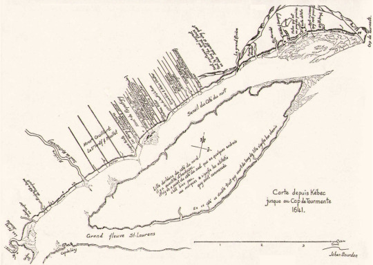
    Established in 1627 in New France, the seigneurial system was a feudal way of distributing land and creating subsistence farming for those who occupied it. It was ultimately abolished in 1854, but you can still see vestiges of it.

    With the seigneurial system, a typical farming lot was a long and narrow strip of land emanating from the water, which in this particular case was the St. Lawrence River. Here’s a map from 1641 showing what that looks like:
    image

    The reasoning behind this spatial arrangement was rather simple. By having long narrow lots, it meant that you could maximize the number of farmers who had direct access to water. This was needed for navigation, but also for many other obvious reasons. This was an efficient layout.

    At the same time, the long strips meant that each farmer had access to a broad cross section of different kinds of land. They had fertile land for growing, land for their home, and frequently land with trees so that they had material to build, fuel to burn, and so on. It also meant that, despite the overall lot sizes, people actually lived fairly close to each other. It created communities.

    Of course, there’s a lot more to the seigneurial system than just its physical form and there are reasons it was eventually abolished. But today I just want to focus on spatial layout. Because I think there are parallels to how we continue to plan our communities.

    If you live in a city you’ve probably come across a narrow rowhouse, a narrow townhouse, and/or a long and narrow condominium – which many people like to pejoratively refer to as a “bowling alley” plan. In these cases, the width of the home could be somewhere between 10 and 13 feet.

    If you stop and think about this, it’s exactly the same spatial principles as the seigneurial land use system. But instead of maximizing the number of people with access to the St. Lawrence River, it’s about maximizing the number of people who front onto the street and who have access to natural light.

    In tight urban conditions, it’s not uncommon to have no “side yard windows.” In my case, I live in a condominium with 20′ feet of windows on one side only. The other 3 sides of my box have none. And that’s a fairly common urban condition.

    I find this interesting because as much as the world is rapidly changing, some things don’t actually change all that much.

    Image: Wikipedia

  • ■ by (shinya*)