Daily insights for city builders, delivered every morning at 6 AM ET. I’m Brandon Donnelly — a Toronto-based real estate developer and founder of Globizen. I’ve been writing here since 2013.

Tag: urbanization

  • Is the world urbanizing or suburbanizing?

    The Economist recently published an essay called, A Planet of Suburbs – The world is becoming ever more suburban, and the better for it. The argument is basically that the “great urbanization” that everyone loves to talk about these days is actually a misnomer. From Chicago to Chennai, it’s not the urban core that’s growing. It’s the suburbs. And so what we’re seeing should actually be called the great suburbanization.

    The basis for this argument is that wealth fuels sprawl. As people become richer, they naturally consume more of everything – including space. It’s a natural market outcome.

    Take for example, the path of many of Toronto’s ethnic groups. In the first half of the 20th century, College Street was the Little Italy. Then it shifted north and St. Clair Avenue West became the more authentic Little Italy. Today, many Italians now live north of the city in Woodbridge. In fact, last weekend I was on St. Clair West and was disappointed to learn that one of my favorite butchers had closed up shop and “moved to Woodbridge.”

    However, there are also many supporters of the exact opposite outcome. From Edward Glaeser to Alan Ehrenhalt, many have argued that we’re in the midst of a “great inversion.” The suburbs are no longer a threat to urban centers. It’s the urban centers who are threatening the suburbs. The suburbs are dead. Long live the city.

    So which is it?

    Well, The Economist does cite two examples where true urbanization is actually taking place. It’s happening in Tokyo and London. In both cases, it’s the city center that is growing the fastest – not the suburbs. The explanation for Tokyo is its aging population. And the explanation for London is its restrictive greenbelt, which effectively stops the possibility of any further sprawl.

    Here in Toronto – where there is also a greenbelt in place – we know that the population of the downtown core is growing at an incredible pace. A recent report by the city – called Comprehensive to the Core – revealed that the downtown core is growing at 4 times the rate of the rest of the city.

    But what about the suburbs?

    If we look at the province of Ontario’s growth projections, it is indeed the suburbs which are expected to grow the fastest up until 2036. Here is a diagram showing percentage growth rates:

    image

    In absolute numbers, the city of Toronto alone is expected to add about 0.66 million people between 2012 and 2036, and the suburbs are expected to add almost 1.9 million.

    There are a number of potential explanations for this differential, but I think it’s largely because land is cheaper in the suburbs, it’s easier to add new housing supply, population densities are lower, and we’re talking about very different land areas.

    The city of Toronto is 630 square kilometers. If you tack on the suburbs, the Greater Toronto Area is 7,124 square kilometers. That means Toronto makes up less than 9% of the total land area. And yet it is expected to contribute 25% of the region’s population growth. 

    Still, the suburbs are where the bulk of the population growth is expected to happen over the coming decades.

    However, the “great inversion” that authors like Alan Ehrenhalt have been talking about should not really be interpreted as the death of the suburbs. What he’s instead talking about is a socioeconomic or demographic reversal: center cities used to be poor and now they’re becoming rich.

    Here’s how he put it:

    What we are seeing is a reversal in which the words “inner city,” which a generation ago connoted poverty and slums, [are going to mean] the home of wealthier people and people who have a choice about where they live, and the suburbs are going to be the home of immigrants and poorer people. And Census figures show that that’s taking place.

    In this context, we are still living through the great urbanization. We’re seeing a shift in consumer preference and a shift in where wealth is choosing to locate. That’s a profound change.

    And while we’re obviously still suburbanizing, I don’t agree that we’re better for it. In fact, left unchecked, this demographic inversion could actually prove to be quite damaging to our suburbs.

    Image: Flickr

  • Is there an urban planning pendulum?

    Take a look at this tweet I came across yesterday:

    image

    A different way of thinking, a century apart. pic.twitter.com/GoxUQs0bB4

    — Darren Proulx (@dnproulx)

    May 5, 2014

    //platform.twitter.com/widgets.js

    On the left is a picture of some crowded and dense city at, I presume, the turn of the 20th century. And on the right is a picture, today, of your generic suburban city with lots of cars, a broad street and auto-oriented signage everywhere.

    As the captions say, the city on the left is what modernist architects like Le Corbusier and powerful city builders like Robert Moses were trying to fix. What we ended up with, as a result of these efforts, is the city on the right. Now, today, we–architects, planners and urbanists–are all trying to correct what we see as a huge misstep in the way we designed and built cities.

    But is it really an anomalous misstep or is it simply a preferential pendulum that swings back and forth from generation to generation? One generation thinks cities are dirty and evil and that they need to be evacuated. And then the next generation loves them and wants to move back into them, which is what’s happening today.

    Dogma–particularly when it comes to cities–takes a long time to percolate through the system. Le Corbusier was espousing his city building ideals of “towers in parks” in the 1920s. That’s when he proposed to demolish 2 square miles of Paris (Plan Voisin) and turn it into what most people today would think looks like a New York public housing project.

    But for these new ideas to take hold, young architects, planners and builders first need to become indoctrinated in school or wherever they’re learning the ropes. Then, they need to get out and start practicing and mature to a point where they’re starting to influence and control substantial city building decisions. That’s why, I think, Le Corbusier’s ideas of the 20s really only became widely accepted as planning principles in the post-war years.

    Because of this though, I sometimes wonder if I too am just following the natural cycle of changing tastes. When I went to architecture school, we were taught that public transit is more efficient than private cars, density is good for the environment and for economic development, and that Le Corbusier was generally a crappy city builder. And if you’re a regular reader of this blog, you’ll know that that is generally the view I take here.

    But when I ask myself this question, I think of a few things. First, if you look at the urbanization of ancient cities, they were always organized around strong public spaces. The desire for human beings to be able to walk around, conduct business and socialize with each other is not a new phenomenon. And our post-war planning ideals put a strain on that.

    Second, take a look at the world and what’s happening. The majority of people now live in cities and we’re continuing to urbanize at a frenetic pace. Shenzhen in China went from a population of just over 300,000 people in 1979 to over 10.5 million people today. That is the pace of urbanization that city builders need to deal with. It’s unprecedented.

    And to even begin to make that manageable, I don’t think we can continue to build cities like the ones on the right side of the picture, above. It’s unsustainable both environmentally and from a mere space planning standpoint. There simply isn’t enough room.

    So call me a product of the times, but I just don’t see our current planning goals as one side of a swinging pendulum. I see them as a return to what cities have always been about: a place for people to interact, socialize and generate wealth.

  • How Facebook is using its data to analyze global migration patterns

    More and more people are moving to cities. This much we know. But in our fast paced world, census data is becoming increasingly limited in its ability to tell us exactly where and how people are moving.

    Thankfully we now have Facebook. 

    image

    I just discovered a fascinating study conducted by the Facebook Data Science Team called “Coordinated Migration.” What they did was anonymously analyze every Facebook user that has inputted both a hometown and a current city to see where people of a particular hometown are most likely to live, today.

    But more specifically, the study is looking at coordinated flows, rather than just total flows to a particular city. A “coordinated migration” is defined as an instance where “a significant proportion of the population of a city has migrated, as a group, to a different city.”

    What the study found (perhaps not surprisingly) was that the vast majority of coordinated migrations are happening in countries that are in the midst of rapid urbanization. It’s a case of people moving within the country to its largest city.

    Here are the top coordinated migration destinations:

    If you’re interested in the nitty gritty of how they actually computed the coordinated migrations, check out the original post by the Facebook Data Science Team.

  • Urbanization in the developing world

    A few days ago I asked a reader of this blog if there was anything, in particular, that she’d like to see more of on here. She responded by saying that she’d love to learn more about how other cities—outside of Toronto—are managing urbanization, as well as how we shape cities and cities shape us.

    It’s an interesting and important question because, frankly, the challenges are greater outside of Toronto. One of the stats that often gets cited here in the media is how the Greater Toronto Area gets approximately 100,000 new immigrants every year. This doesn’t include domestic migration though, so I would assume that our total number is even greater.

    But if we stick with 100,000 for now, it means the GTA receives about 11.4 new immigrants every hour (100,000 people / 8,765 hours in a year). Lagos, Nigeria, on the other hand, receives between 50-60 new people every hour. In fact, it’s predicted to be 7th fastest growing city in the world between now and 2020. 

    If you take a look at the complete list of the world’s fastest growing cities (all estimates, of course), you’ll likely notice that the vast majority of the cities are in the developing world. And that’s really the challenge. The world is rapidly urbanizing and becoming the most urban it’s ever been, but the changes are the greatest outside of developed nations. This poses entirely unique challenges.

    Of the kinds of cities I’m talking about, I’m most familiar with Dhaka, Bangladesh. In my last year at Penn, I was part of a studio led by KieranTimberlake Architects that focused on water and housing issues in that city. It was a partnership with the University of Dhaka. We spent roughly 2 weeks there and it was an eye opening experience.

    Here’s a telling slide from our final presentation:

    image

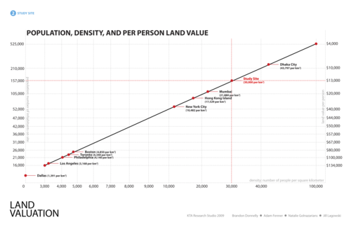
    What we were trying to do with this chart was compare population and per person land value for our development site according to various city types. In other words, we were essentially asking: If we were to build out our proposed site in the same way, as say, Dallas, Los Angeles, Hong Kong, or what is typical for Dhaka, how many people could we fit and what would be the resulting per person land value?

    I don’t remember where we got the land value figures from, but we were trying to be cognizant of the fact that every city requires a unique solution. Using the same per person land values in Dhaka as in Dallas would be unimaginable because Dhaka has over 40,000 people per square kilometre (top right on the diagonal line above) and Dallas has under 1,400 per square kilometre (bottom left on the diagonal line above).

    The challenges of urbanization in the developing world are profound, particularly in places like Dhaka where most of the city is subject to severe annual floods. By some estimates, 18% of the city’s land area gets flooded every year—talk about adding another layer of city building complexity.

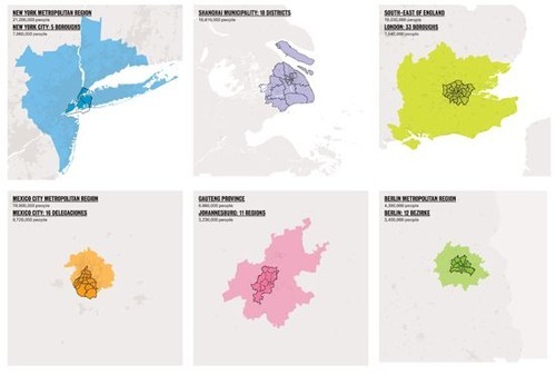
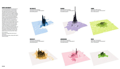
    We didn’t solve all of the problems in that studio and we’re not going to do it here, but I do think it’s important to fully understand the problem. One of my favorite books on cities is called “The Endless City.” It examines New York, Shanghai, London, Mexico City, Johannesburg and Berlin, and has a ton of great data and diagrams.

    Here are a two that outline densities and land use patterns for the above 6 cities (same order starting on the top left):

    image

    image

    If you’re interested in cities, it’s definitely worth having it on your coffee table. And fitting to @PhatNancy’s tweet, ”The Endless City doesn’t just show how cities are changing but also how they are changing us.