Daily insights for city builders, delivered every morning at 6 AM ET. I’m Brandon Donnelly — a Toronto-based real estate developer and founder of Globizen. I’ve been writing here since 2013.

Tag: urbanism

  • Scootering around New York City

    image

    I am writing this post on a Porter flight from New York back to Toronto.

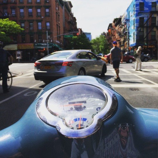
    For my last day in New York, my close friend and I rented scooters and rode all around Manhattan and Brooklyn. It was a great way to cover a lot of ground, but also a great way to still absorb the city. It’s harder to do the latter in a car and I never have any desire to drive in New York.

    Because the great thing about New York is that as a pedestrian you feel like you control the streets. When you’re waiting at a crosswalk, you’re never actually waiting. You walk off the sidewalk and onto the street so that you can assert yourself in front of the cars and wait for an opening. This serves to narrow the portion of road that the cars can actually drive on and reminds the drivers who is boss.

    At the same time, there are many instances throughout the city where New York has purposefully reallocated the space dedicated to pedestrians (and cyclists) and the space dedicated to cars. They’ve created new public spaces, widened the areas where people can walk, and seemingly blanketed the city with bike lanes. And that makes a lot of sense given that in many (most?) areas of the city, pedestrians greatly outnumber cars.

    So does that mean New York is at war with the car? (I’d be curious to know – in the comment section below – if those kinds of discussions take place in the city.)

    I suppose you could spin it that way. But New York also does things for cars. While riding around on the scooter today, I was so impressed by how well timed the streetlights were along the avenues. It made it incredibly easy to go downtown or uptown. In Toronto, I often feel like we time our lights to make driving as slow as possible.

    But make no mistake; New York is not a driving city. 

    New York is about walking, biking, taking transit, and hailing cabs. There is a reason they have the highest transit ridership in the US. The city is built for it. And unless driverless cars and ride sharing completely changes the equation, I will continue to believe that transit is the most efficient backbone for any big city.
  • Walking the West Side Highway

    image

    I am in New York this weekend. Every now and then I need to get my fix of this city. I just love it here.

    Given the debate that’s going on in Toronto right now about the elevated Gardiner Expressway, one of the things I wanted to do this weekend was walk the West Side Highway. The West Side Highway runs along the western edge of Manhattan from 72nd Street all the way down to the southern tip of the island. It used to be an elevated highway, but it runs mostly at grade now.

    I’ve been to and on it many times before, but I wanted revisit it with a different lens. Many people in Toronto seem to think that if we remove the Gardiner East and replace it with an enlarged Lake Shore Blvd that it would pose just as much of a physical barrier as an elevated structure.

    So I walked the West Side Highway and filmed this (Hyperlapse) video:

    //platform.twitter.com/widgets.js

    I think it’s a big improvement over an elevated structure. What do you think?

    There is, however, an elevated highway uptown. So tomorrow I plan to travel it on a scooter that I’ve rented to see how the urban fabric changes around it. I suspect it’ll be quite different.

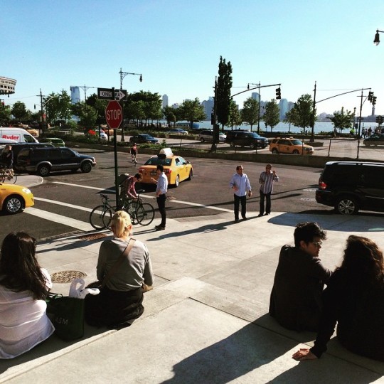
    In case you were wondering, the picture at the top of this post is from the steps at the Whitney Museum. They face the West Side Highway and the water. It’s a great public space, but I’m pretty sure that Renzo Piano wouldn’t have designed it that way (and with that orientation) had there been an elevated highway in front of it.

  • Real estate and house music in Johannesburg

    I’ve written about the Ponte Tower in Johannesburg before. At 54 storeys, it is the tallest building in Africa. It’s located in Hillbrow, which is an inner city neighborhood known for its crime and poverty. 

    In the 1970s when the tower was built, Hillbrow was an Apartheid-designated white-only neighborhood and the tower was filled with affluent residents. But that didn’t last long and eventually the wealth fled for the suburbs.

    Here’s a brief 6 minute video talking the Ponte Tower. Let’s call it the real estate perspective. Click here if you can’t see it below.

    [youtube https://www.youtube.com/watch?v=3EIKmmSifqw?rel=0&w=560&h=315]

    Now, here’s a Real Scenes documentary talking about the thriving electronic music scene in Johannesburg. I think it’s fascinating to look at a city from a particular subculture and, compared to the first video, I get a very different feel for the city. Click here if you can’t see it below.

    [youtube https://www.youtube.com/watch?v=Ykt2f6o7-e8?rel=0&w=560&h=315]

  • Locations of the 100 tallest skyscrapers in the world

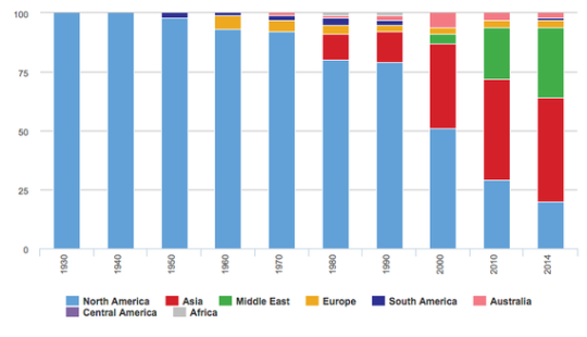
    This morning I stumbled upon the following chart (via The Atlantic) summarizing the locations of the 100 tallest skyscrapers in the world.

    As you can see North America dominated tall buildings for most of the 20th century. But then in the 1980s, Asia starting building. Then in the 2000s, the Middle East started building. And today, Asia and the Middle East are where the world’s “supertalls” sit.

    What’s fascinating about this shift is that in many cases, there’s absolutely no physical or economic need to developing so tall. Yes, rising land values can drive up the height of a building, but not to the extent that we’ve been seeing.

    Instead, building “the tallest building in the world” is more symbolic than anything else. It’s about ego. It’s about asserting your position on the global stage. And so while this is a chart about tall buildings, it’s actually a pretty telling chart about global ambitions.

  • 4 design strategies for your cold-climate waterfront

    Photograph Sugar Beach in Toronto by christophmarten on 500px

    Sugar Beach in Toronto by christophmarten on 500px

    Since we’ve been discussing waterfronts lately, I thought I would share this post from ArchDaily talking about 4 ways that cold-climate cities can make the most of their waterfronts.

    They are:

    1. Plan for winter sun
    2. Create plazas that block wind
    3. Break up outdoor spaces with comfort stations (not sure why they just have to be stations)
    4. Design for active winter programming

    These, of course, aren’t new design strategies. Cities have been built around their climates since, probably, the beginning of cities. It wasn’t until more recently that we started basically ignoring local climates and focusing more on what mechanical systems can do to make us feel comfortable.

    But I think that was a mistake. I don’t think that mechanical systems are bad though. I just think that there’s a lot that we can do first – without mechanical systems – to address local climates.

    If you’ve ever sat on a patio during a swing season (i.e. right now) where the wind was blocked and you were in the direct sun, you already know that there’s a lot that can be done without relying on active systems.

    But the other thing I like about this post is that it acknowledges the fact that winter waterfronts require just as much, if not more, design attention than a warm-climate waterfront.

    Saying that we’ll (insert cold-climate city name here) never be Miami or Barcelona or Sydney is just giving up.

  • The perfect high street

    How do you create and maintain a thriving high street in this era of increasing online shopping? This was one of the questions that Monocle asked at its recent Quality of Life Conference in Lisbon and here’s a video with its recommendations. Click here if you can’t see the video below.

    [youtube https://www.youtube.com/watch?v=Ox2WJwDbuIo?rel=0&w=560&h=315]

  • When the crowd builds a city

    I’ve been following and checking out Kickstarter pretty much since the beginning. But it wasn’t until last night that I backed my first project. 

    After doing that, I immediately started thinking about urban projects that might be able to also get crowdfunded using Kickstarter. How could it be used for city building? A Kickstarter project, after all, just has to be something with a defined scope and a clear end goal.

    Not surprisingly, this has already been happening for many years now.

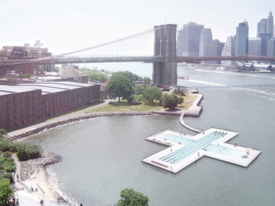
    A great example is +Pool in New York, which is an initiative to build a publicly accessible floating pool that also filters river water. The project launched in June 2011 and by July 2011 they had raised $41,648 USD to build and test different filtration techniques.

    image

    Today, the project is still moving ahead and they are now offering up the opportunity to buy and have your name engraved on tiles within the pool. If I lived in New York, I would be all over this.

    But what’s powerful here is the ability for crowd-based platforms (like Kickstarter) to both get radical new ideas off the ground and to empower local communities to affect change. Here’s a quote from PSFK:

    It’s very difficult to get funding for these ‘out there’ ideas that regular systems might not support. Creators have to take risks and be imaginative, as well as put their ideas out there and let the public decide. There are no traditional guidelines on crowd-sourced platforms—they’re much more meritocratic. You can think in big scope and that changes what gets made and who can access it. Anybody with a couple of doubles can voice what they want to be built, and in that way we see the entire community having a huge say in the design world.

    And when I see projects and platforms like this, I can’t help but wonder if (when) city building is going to become even more decentralized. 

    Last night I was also at an event – being put on by Ryerson University’s City Building Institute – called Bridging Divides: What Can Cities Do? And one of the suggestions that came up was that Toronto needs more local and granular community councils (there are currently 4) in order to bridge some of the divides that are happening in our city.

    But in a world where it’s possible for each and every person in a city to not only have a say but to quickly say it from their smartphones, why can’t we go even more local? Instead of 4, 10, or 90 community councils, why can’t we have everyone more engaged?

    I think we’re headed in that direction.

  • “Regulation for thee but not for me”

    Urbanist Aaron Renn recently published an interesting article in City Journal called “Libertarians of Convenience”. It talks about how today’s urban progressives are selectively favoring deregulation for the things that only matter to them – everything from urban housing to food trucks.

    Here’s a snippet:

    But it’s hard to avoid thinking, too, that some of the inconsistency reflects elite biases. The things that liberal-minded city residents like and want to do—eat from hip food trucks, smoke dope, and other “bourgeois bohemian” pursuits—should be left as free as possible, consequences be damned (raw-milk advocates downplay the nearly 1,000 cases of illnesses caused by it from 2007 through 2012). Those that they consider déclassé—Big Gulps, Marlboro Lights, McDonalds—should be restricted or even shut down. It’s regulation for thee but not for me.

    I like his angle, because we’re probably all – at least a little – guilty of subjectively wanting more of the things we like and less of the things we don’t like.

    What do you think of his argument?

  • The infrastructure sandwich

    Today I came across the following tweet by Brad Tabke. (Brad is the mayor of Shakopee, Minnesota.)

    //platform.twitter.com/widgets.js

    On the left of the image is downtown Memphis. On the right is the Mississippi River. And in the middle is, well, a bunch of elevated highways. 

    It’s a powerful image regardless of where you happen to be from. But if you’re from Toronto, you might know why I’m posting it today.

  • Red stripes, iceberg homes, and laneway houses

    This morning I was reading a CityLab article talking about a homeowner in London’s wealthy Kensington neighborhood who painted her house in red stripes after the city and her neighbors derailed her renovation plans. I’m thinking it is supposed to be symbolic of government “red tape.”

    She had hoped to add a two-floor “mega-basement” to her home, which is curiously enough a thing in London due to how restrictive traditional home expansions can be. Locally they are called “iceberg homes.”

    What’s interesting about this phenomenon is that it shows you how far people will go to find and/or create the space they want in the neighborhoods they want to live in. Kensington is an incredibly wealthy area and so one has to assume that she is not without other housing options.

    As another example, here’s how the article describes her house:

    The candy-striped home in question, for example, is actually a mews house, a kind of outbuilding running along an alley behind a great house, originally intended as a place to tidy horses, carriages and maids away from the main residence.

    So not only did she want to create an “iceberg home”, but she wanted to do so in what was previously a back alley. In Toronto, this home would be called a laneway house.

    What this tells me is that as real estate values rise, people will naturally start to seek out overlooked spaces to repurpose. They will look for some way to carve out a home. And it’s for that reason that I think laneway housing is an inevitable outcome here in Toronto.