Daily insights for city builders, delivered every morning at 6 AM ET. I’m Brandon Donnelly — a Toronto-based real estate developer and founder of Globizen. I’ve been writing here since 2013.

Tag: urbanism

  • Good vibrations

    image

    There are 614,387 bridges in the United States and 55,707 of them are thought to be structurally deficient according to the US Department of Transportation (2016). About 188 million people cross “a deficient bridge” every day in the US (also a 2016 figure).

    Inspections are often infrequent and only visual, and so MIT Senseable City Lab is currently on a mission to come up with a more scientific approach. They believe that there’s a solution in crowd-sourced data and that it’s possible to create a community-driven maintenance program.

    What they discovered through a recent study, called Good Vibrations, is that mobile phone sensors can actually pick up the natural vibrations and oscillations of a bridge. And, that a mobile sensor located within a traveling car is actually 120x more precise than fixed sensors located on the bridge.

    Part of the problem is that fixed sensors have poor spatial coverage. They are located in specific locations. Whereas mobile sensors give you data across the entire span of the bridge as someone crosses it. And if you know how a bridge normally vibrates, you can quickly tell when something is off. 

    Here’s a quick video overview of the study. And here’s what you should do if you want to get involved.

    Photo by Joseph Barrientos on Unsplash

  • Urbanizing the suburbs

    Commuter rail has typically functioned as a way to bring people from the suburbs into downtown for employment, and sometimes recreation. That has typically translated into good inbound service in the mornings, good outbound service in the evenings, and mediocre service the rest of the time. It has also historically meant lots of subsidized surface parking. Free parking was (and still is) often thought of as the key to putting bums in seats and increasing ridership.

    Here in the Toronto region, this service is provided by GO Transit, which, since 2009, has been owned by Metrolinx. But as one of the fastest growing regions in North America, this kind of service and thinking has become increasingly antiquated. That’s why Metrolinx and the Government of Ontario are working to profoundly change the economic geography of this region by both electrifying the lines and implementing 15 min, all-day two-way service. 

    This may seem like an incremental improvement, but it is not. It is a significant change that will transform the service from commuter rail to regional express rail. Of course, this now means that it is time to rethink the land use policies and built form that surround these key transit nodes. One of the places where this is happening today is at the Clarkson GO Station. The City of Mississauga is in the midst of a planning study that will ultimately guide future development around the station. 

    I think this one of the most important shifts taking place right now in this region and elsewhere. It is the maturation of our suburbs and it is going to result in more walkable and vibrant urban places across our cities. So if you have a few minutes, I would encourage you to complete this survey that the City of Mississauga recently put out. The results will help to guide their Clarkson Transit Station Area Study. 

    I also think think it is worth completing the survey even if you aren’t local to the area. How to urbanize the suburbs is a universal problem.

  • Sidewalk Toronto releases draft site plan for Quayside

    Yesterday Sidewalk Toronto released its draft site plan for Quayside. Here’s what it looks like:

    There’s a big emphasis on people-first streets and on the public realm. I like the idea of a waterfront plaza at the tip of the Parliament slip and of a floating walkway bridge to Promontory Park (bottom right hand corner of the above image).

    There are also a number of more enclosed pedestrian laneways and courtyards, which I am sure will result in more favorable microclimate conditions. That matters, especially on the water.

    Here are some high level project stats:

    • All mass timber construction
    • Five “sites”
    • Buildings ranging from 3 to 30 storeys
    • 68% residential (40% of the residential will be below-market, with 20% being affordable and 5% being deeply affordable)
    • 20% commercial
    • 15% flex space (retail, production, arts, community)
    • ~2,500 residential units

    A full copy of the draft site plan can be downloaded, here.

    Image: Sidewalk Toronto

  • How London became the center of the world

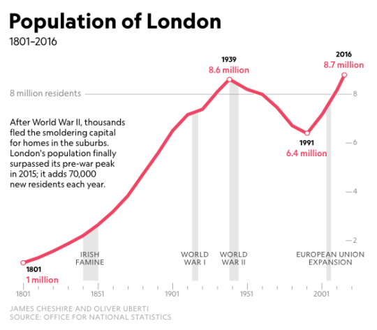
    Some of you may want to debate the “center of the world” title (New York may be more deserving), but Laura Parker of National Geographic recently published a great essay describing the tremendous growth that London has seen over the last 30 years thanks to in part the deregulation of the financial services industry. Here is an excerpt:

    As the manufacturing industry splintered, the docks of what was once the world’s largest port fell victim to shipping modernization and closed. The death in 1965 of Winston Churchill, the great prime minister, marked “the last time that London would be the capital of the world,” the Observer noted. Population continued a downward slide, bottoming out at 6.7 million in 1988. By then London’s fortunes had changed with deregulation of the financial services industry, known as the Big Bang, along with the shift to electronic trading, which enabled London to rival Tokyo and New York. A new financial district rose on the ruins of the West India Docks on the Isle of Dogs, a marshy nub that juts into the Thames. Canary Wharf, as the district is called, became London’s first modern large-scale regeneration project.

    According to National Geographic, London’s population grew by about 1.2 million between 2006 and 2016. That’s a pretty incredible number and is why the city estimates that they need about 66,000 new housing units a year just to keep up the growth. Like many supply constrained big cities, they’re not meeting that target.

    For the full essay, click here. It comes packaged with some incredible photographs by Luca Locatelli.

  • A decentralizing or centralizing force?

    I was on two panel discussions over the last week and, as is the case with all real estate panels, the topic of parking invariably came up, as did the impact of autonomous vehicles.

    There seems to be a general consensus that the advent of driverless cars will result in less demand for parking. Every developer I know is trying to build as little parking as possible and is thinking about how – when the time comes – they might convert their parking into something more productive. I have yet to speak to anyone who is building excess parking in order to prepare for autonomy.

    Where there’s a split, however, is whether autonomous vehicles will represent a decentralizing or a centralizing force for our cities. Historically, new technologies have lowered transportation costs and encouraged decentralization. Before the advent of rail, the US population hugged the coasts, because it was cheaper to navigate across the Atlantic than it was to move inland.

    A similar phenomenon also played out with our streetcar suburbs and with our car-oriented suburbs. These new technologies made it possible for people to travel further distances in order to get to work and other places. So it is not at all surprising that many people today are inferring that autonomous vehicles will produce this same outcome.

    But there is a counterargument. 

    We know that the demand for transportation services is highly elastic. Uber and other ride sharing apps have demonstrated this to us. Lower fares translate into dramatic increases in demand. So the opposing argument is that as the cost per kilometer drops – autonomous electric vehicles are going to be much more cost effective to operate – we’re going to see boatloads of induced demand.

    This induced demand will then force us to look toward road pricing and other demand management tools in order to cope, which then begs the question: How much cheaper and more convenient will autonomous vehicles really be? 

    At the same time, it is important to acknowledge that autonomous vehicles should correct many of the inefficiencies currently caused by humans acting like humans. There is also the opportunity to operate these autonomous vehicles more like public transit than as personal vehicles. And that will have a profound impact on urban mobility.

    Still, it is not yet clear, at least for me, that autonomous vehicles will be the decentralizing force that many assume they will be.

  • Shortage of cities

    Joe Cortright of City Observatory recently looked at “the myth of revealed preference for [the] suburbs.” In it, he cites the work of Jonathan Levine, who is the author of a 2006 book called, Zoned Out: Regulation, Markets, and Choices in Transportation and Metropolitan Land-Use.

    There’s an argument out there that, on average, people prefer the suburbs to urban neighborhoods because, well, more people in the US live in auto-oriented neighborhoods compared to urban ones. What Levine wanted to figure out was whether this was truly a result of consumer preference or simply a lack of urban neighborhoods – or a “shortage of cities” as Cortright calls it.

    To do this Levine examined two cities with very different urban fabrics: Boston and Atlanta. The idea was to take a city with lots of urban neighborhoods (Boston) and compare it to one with relatively few (Atlanta). 

    For his comparison, he classified all of the neighborhoods in both cities on a scale according to how urban they were. “A” meant very urban. And “E” meant sprawling/exurban. He then went out and interviewed residents, asking them about both the kind of housing they would ideally like to live in and how happy they were with their current housing. 

    What Levine discovered, among other things, was that in Boston – where about half of all housing fell into the top 3 most urban categories – about 83% of people with a strong preference for urban neighborhoods were also living in one. Whereas in Atlanta, just 48% of people with a strong for urban neighborhoods were living in one.

    Put differently, the study suggests that in cities with fewer urban neighborhoods, it is more difficult for people with a preference for that housing type to find and live in it, which makes intuitive sense. The spread between preference and reality widens, once again suggesting that this could be about supply rather than an issue of demand.

    Anecdotally, I have seen this phenomenon play out here in Toronto. I often hear people talk about the neighborhoods that they would ideally like to live in, if only they could find a reasonably priced home. (Low supply leads to upward pressure on pricing.) How aligned would you say you are with your ideal level of urban-ness? 

    For more on Levine’s work, head over to City Observatory.

  • One year anniversary of the King Street Transit Pilot

    I had dinner tonight on King Street and I was reminded that this week marks the one year anniversary of the King Street Transit Pilot here in Toronto.

    The pilot has certainly had its share of controversy, but the improvements to both transit reliability and ridership are clear. Average travel times (in each direction) have increased by as much as 7 minutes on the route.

    Here’s the latest data from July and August of this year. Steve Munro can also tell you everything you ever wanted to know about the King streetcar.

    As our city continues to grow, many are naturally concerned about the ability of our infrastructure to handle the additional demands. Where will all the cars go?

    But the reality is that we will never be able to accommodate everybody driving around in their own car. Which is why we have to rely on transit and solutions like the King Street Transit Pilot.

    What’s your opinion of the pilot now that it has been in place for a year? I almost forget what it was like before we had it.

  • City-states and superstar cities

    During the recent election here in Toronto, mayoral candidate Jennifer Keesmaat raised the idea of this city region, maybe, becoming its own province. It wasn’t the first time this idea has been floated, but it once again didn’t stick.

    Earlier this week, Richard Florida spoke at the Urban Land Institute’s Toronto symposium and he brought up a similar issue: Toronto is a ‘city state’ and needs to start acting like it. Here is an excerpt from a recent Star article about his talk:

    He also noted that in terms of total economic output, the GTA [Greater Toronto Area] — he included the Golden Horseshoe — is responsible for about “$700 billion” (U.S) in economic output.

    “Which means our … region is equivalent to that of Sweden. So we are a city state, a mega region.”

    He later added: “we are a powerful global city with lots of assets to build on,” he said.

    But he went on to say that despite all of these successes there’s a “sense that something is amiss, something is wrong.”

    I have long supported the notion that city regions need to see and think of themselves as one united and contiguous economic landscape. In our case, it is not about, for instance, Hamilton vs. Toronto. This is about our entire region vs. New York or Singapore (a city-state) or the Pearl River Delta megalopolis.

    The headlines coming out of Amazon’s recent announcement are clear: In Superstar Cities, the Rich Get Richer, and They Get Amazon. This is winner-take-all urbanism where you need to be a “superstar” in order to compete. 

  • Forever

    About a month ago, I said on the blog that we had partnered with two local artists for our Junction House project. The first was Leeay Aikawa and the second was a surprise. 

    Well the second one is no longer a surprise. It is Ben Johnston and he started work on his mural this evening. Here is a photo (courtesy of Shanique Small – thank you!):

    image

    It should be completed this week if you’d like to stop by 2720 Dundas Street West. I am planning to be there this Saturday to take some photos and generally just hang out in the Junction. 

    Stay tuned for more surprises. 

  • Tech and the North American office market

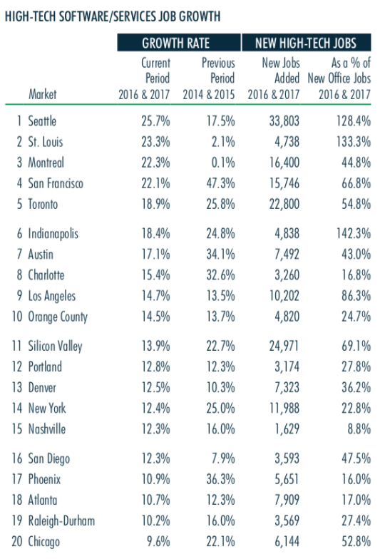
    CBRE recently published this report looking at the impact of the “high-tech software/services industry” on the North American office market. 

    Here are a few highlights:

    – Since 2010, tech has created ~1.1 million jobs in the US at an annual growth rate that is 3x the national average.

    – Seattle currently has the fastest tech job growth in North America. This is the first time in 7 years that San Francisco hasn’t been at the top of their list.

    – Silicon Valley, Toronto, New York, and Los Angeles all added more than 10,000 tech jobs from 2016 to 2017.

    – The biggest “momentum markets”, relying on 2016 and 2017 data, are Montreal, St. Louis, and Seattle.

    – Over the past two years (Q2-2016 to Q2-2018), Atlanta, Los Angeles, Orange County, Seattle, and Portland have all seen double-digit rent growth.

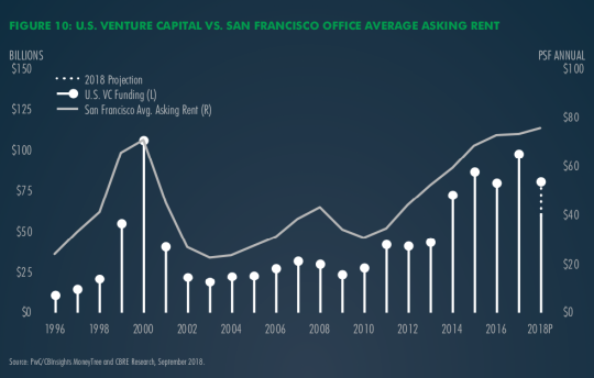
    One figure that also stood out for me was this one here showing the relationship between US venture capital investment and the average asking rent for office space in San Francisco.

    If you’d like to download the full report, click here. You’ll need to sign up for an account with CBRE, but it’s free to do that.