Daily insights for city builders, delivered every morning at 6 AM ET. I’m Brandon Donnelly — a Toronto-based real estate developer and founder of Globizen. I’ve been writing here since 2013.

Tag: urban land institute

  • 5 random charts related to cities and real estate

    I was reading through PwC and ULI’s 2016 Emerging Trends in Real Estate report this evening and a handful of charts stood out to me. They’re not all related to each other, which is why this blog post is called what it is. But I think you’ll find them relevant to many of the things we talk about on this blog.

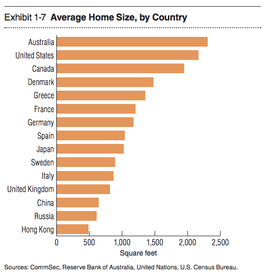
    1. Average home size by country

    With all the interest today in “small urban spaces” it’s interesting to see that the average home size for half the countries on this list is somewhere between 500 and ~1100 sf. It’s also amazing to see Hong Kong hovering just below 500 sf.
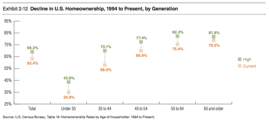
    2) The decline in homeownership in the US

    I like to follow home ownership rates because there’s a lot of debate around whether or not this obsession with homeownership – which has been so central to the ethos of countries like the US and Canada – is at all falling out of a favor. This chart shows some pretty significant drops from previous highs.
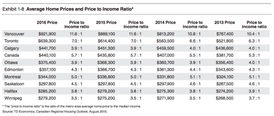
    3) Average home prices and the price to income ratio in major Canadian cities

    Not surprisingly, Vancouver and Toronto are the top of this list with the highest average home prices and the highest price to income ratios (i.e. the worst affordability).
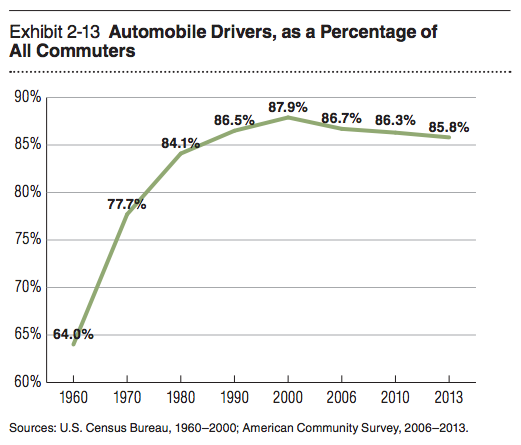
    4) Drivers as a percentage of all commuters in the US

    This chart is similar to what you would see if you looked at vehicle miles traveled. I’ve heard some people say that driving is now once again on the rise, but for the past decade and a half it’s been on a slow and steady decline.
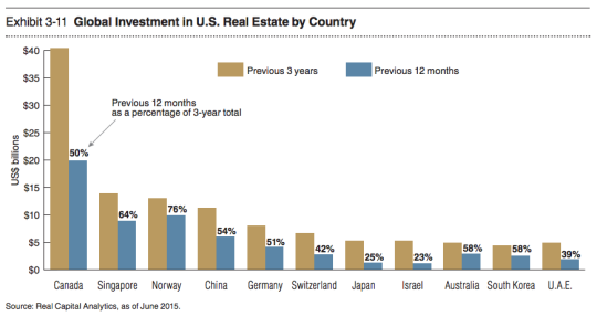
    5) Countries buying US real estate

    Canada is a big buyer of US real estate. But with the dollar where it is today, I am sure that number is headed downwards.
  • Rethinking single family neighborhoods

    image

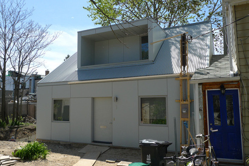
    Earlier this week a good friend of mine sent me a scanned article from this month’s issue of Urban Land Magazine called: Rethinking PADs–Private Accessory Dwellings. He said, I know you have a thing for PADs, so here you go. 

    PADs, or private accessory dwellings, is simply another term for nanny flat or laneway house. Whatever you want to call it, the concept is the same. It’s about taking a single family house and adding an additional dwelling onto that same lot. 

    In many cities around the world, this is not allowed. Each lot is to have only one dwelling unit. And that’s because the single family home – particularly in North America – has been considered sacrosanct.

    But as I’ve argued and demonstrated before, I think we’re on the cusp of this changing. Here’s a snippet from the Urban Land article (unfortunately, I don’t think the full article is available online):

    “If PADs can be added in appropriate scale and number, existing housing, zoned land, and current infrastructure could be efficiently used to increase housing supply and to stabilize and even reduce housing prices. Moreover, since PADs are by definition smaller than existing dwellings, they will attract both younger and older residents who will enrich the intergenerational composition of both urban and suburban communities.”

    I’m happy to see Urban Land (the magazine of the Urban Land Institute) giving this topic some air time. There are a number of social, economic, and environmental benefits to intensifying single family neighborhoods. And the most progressive cities in the world are already doing it.

    What is your city’s position on accessory dwellings? Toronto doesn’t support them. But there are instances where people have gotten them approved.

    Image: Kensington Market Laneway House, Toronto via Flickr

  • My #CityResolve

    Yesterday the Urban Land Institute here in Toronto launched a great social media initiative called #CityResolve. The idea is that instead of making a personal New Year’s resolution, that you instead make one that would benefit your city as a whole. This is great for me because I don’t really believe in New Year’s resolutions.

    You can read more about the initiative here, but all you have to do is tweet your resolve using #CityResolve. One person will be selected for a one-on-one meeting with Toronto’s Chief Planner, Jennifer Keesmaat – where you could then pitch your idea directly to the top 🙂

    For me though, I feel like I’ve already been acting on my resolve, which is this blog. When I started writing every day back in August 2013, I did so for myself, but also for a clear mission: To promote the building of beautiful, sustainable, and globally competitive cities. I don’t profess to have all the answers, but I hope to initiate the right kind of discussions.

    If that feels like a cop out though, here’s another:

    //platform.twitter.com/widgets.js

    What’s yours?

    Image: Flickr

  • Toronto’s Bloor-Danforth subway corridor is a land use crime scene

    image

    Yesterday after my post on leveraging LRT, I stumbled upon an interesting and timely article written by Richard Joy, who is the Executive Director of the Urban Land Institute (Toronto).

    The article talks about some of the transit-oriented development that we’ve seen at various nodes along Toronto’s Yonge subway corridor (St. Clair, Eglinton, Sheppard, and so on). But it goes on to argue that these are exceptions to the rule. For the most part, we’ve missed the boat:

    The tragic history of our massive capital investments into transit infrastructure is massive under-development.

    Indeed, the Bloor-Danforth subway corridor is a land use crime scene.

    His main argument is that until we expand the supply of transit-oriented land (through increased intensification), we will continue to undersupply the kinds of walkable and transit-oriented neighborhoods that many, if not most, people actually prefer. And that, out of necessity, will force people into their cars. Because affordability trumps location preference.

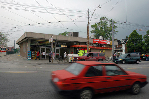
    As one example, he talks about the intersection of Bloor Street and Dundas Street in the west end of the city. Next to Union Station, this is probably the best connected mobility hub in the region. You have the Bloor-Danforth subway line, a streetcar line, and a GO regional rail line which all feed into it. Next year it’ll also become a stop for the new express train to Pearson airport.

    And yet the city has a history of opposing intensification in this location, including the old Giraffe Condominiums proposed by TAS. Does that make sense to you?

    Image: Flickr