Daily insights for city builders, delivered every morning at 6 AM ET. I’m Brandon Donnelly — a Toronto-based real estate developer and founder of Globizen. I’ve been writing here since 2013.

Tag: urban density

  • The longest outdoor escalator system in the world

    This morning I took the mid-level escalators down to Hong Kong station so that I could catch the express train to the airport. At over 800m, it is supposedly the longest outdoor covered escalator system in the world.

    If you’ve ever walked the streets of Hong Kong you’ll know that the ground plane can be inhospitable at times. There’s limited space, but no shortage of steep pitches. I can’t imagine having a physical disability and trying to navigate this city.

    So this system must have been a real innovation when it was constructed in the early 90′s. In total it moves up and down about 135m in elevation. That’s about the equivalent of a 45 storey tower. And I got down from the mid-levels and was on a train to the airport within 15 minutes.

    But because the streets here are so narrow it’s a unidirectional system with one line of escalators. They bring people down to the CBD during the morning rush, but then the direction flips and they bring people up the hill for the remainder of the day — until midnight I believe. Living near these escalators is considered a win.

    Hong Kong Island surely isn’t the easiest of environments in which to build and operate one of the world’s most important global cities. There’s relatively little developable flatland. But they more than made it work by being creative and by building up. Hong Kong is not just a tall city, but a truly vertical city.

    Too bad my efficient morning commute was followed by a cancelled United flight. Tomorrow is not going to be a fun day travel.
  • New York and Toronto population densities compared

    Today I came across this Reddit talking about how few census tracts there are in the United States with a population density greater than 150,000 people per square mile. 

    Basically, there’s a bunch in New York, one in San Francisco (Tenderloin), and one in Chicago that doesn’t really count because it’s an unusually small tract. Most other American cities don’t even come close.

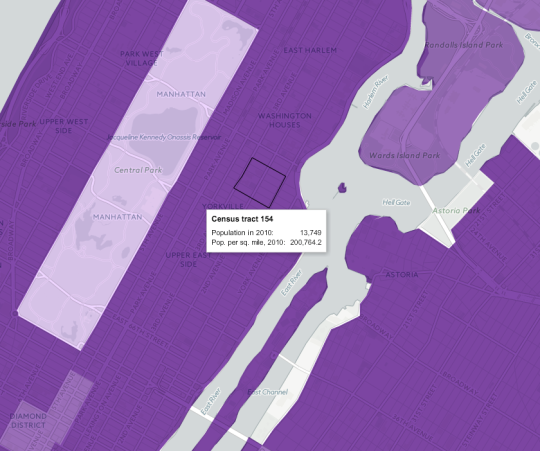
    Looking at this New York Times mapping of the 2010 US census data, it turns out there are neighborhoods in NYC that go well beyond 150,000 people per square mile. Here’s one census tract (#154) at just over 200,000 ppsm:

    If you convert 200,764 into the globally accepted standard for measuring distances and areas, you get approximately 77,515 people per square kilometer. Pretty dense.

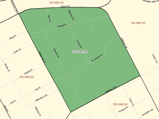
    As a comparison, I thought I would see how this number stacks up against what is commonly referred to as the densest neighborhood in Canada: St. James Town

    If you pull up that geographic code in the 2011 Canadian census data (#5350065.00 in case you’re that nerdy), you’ll see a map boundary that looks like this:

    And you’ll also find a 2011 population density of approximately 60,915 people per square kilometer. Also pretty dense – though the population did decline from 2006.

    Now obviously St. Jamestown is only one example. The rest of the city is, by and large, far less dense. But maybe when our 2016 census data gets released next year, we’ll find that we’ve become even denser. I suspect we will.

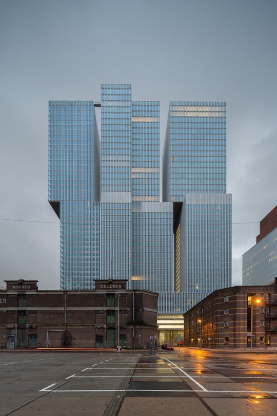
  • De Rotterdam…

    image

    “Manhattanism is the one urbanistic ideology that has fed, from its conception, on the splendors and miseries of the metropolitan condition – hyper-density – without once losing faith in it as the basis for a desirable modern culture. Manhattan’s architecture is a paradigm for the exploitation of congestion.” 

    Rem Koolhaas, Delirious New York, 1978

    Image: De Rotterdam by photographer Ossip Van Duivenbode via The Architectural Review

  • Residential population densities compared

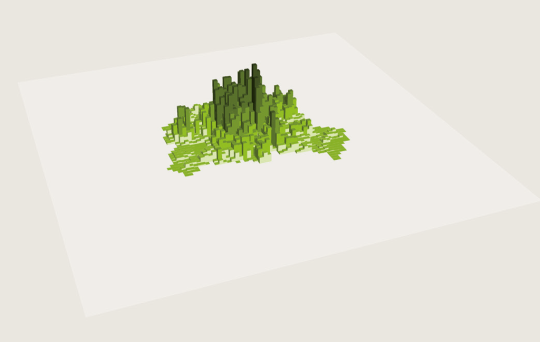
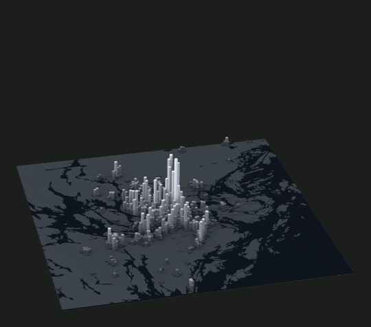
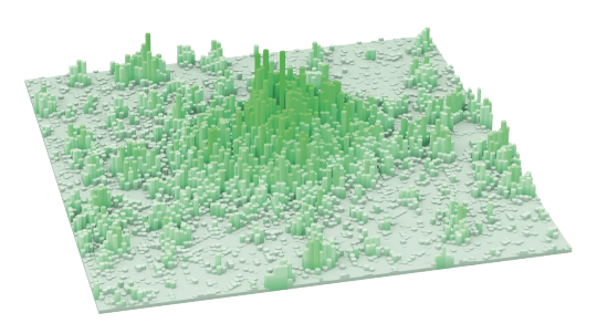
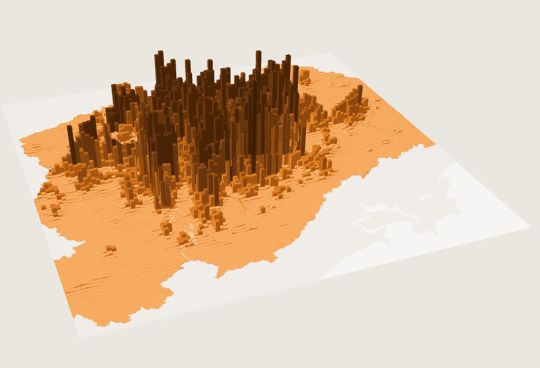
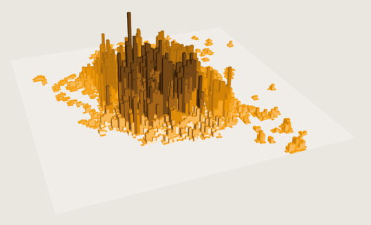
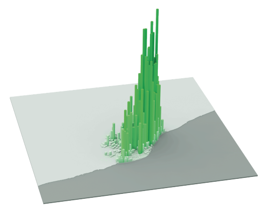
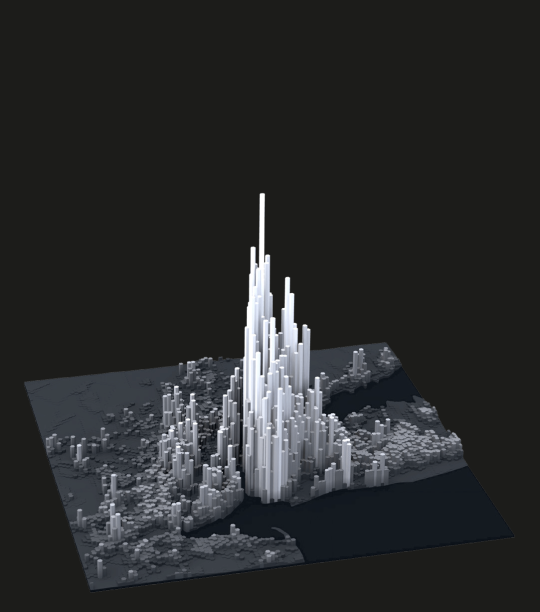
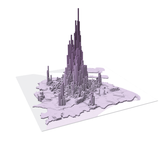
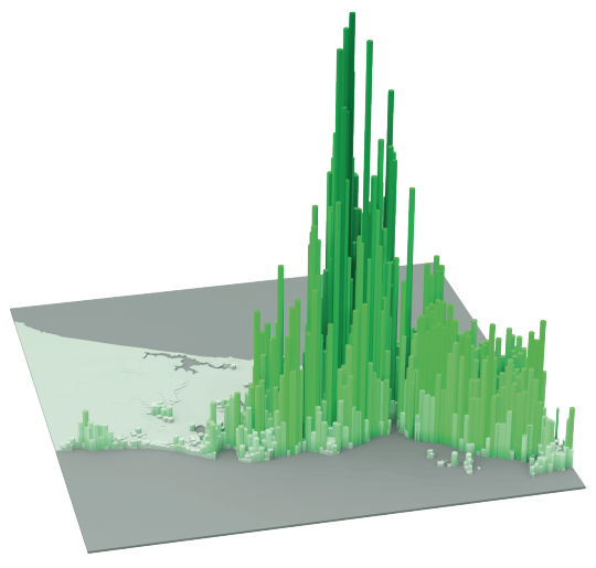
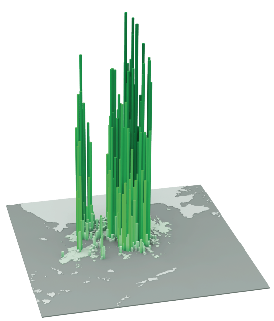
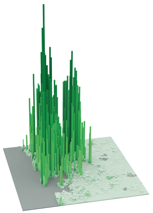
    The following diagrams were taken from LSE’s Urban Age website. I’ve sorted them from lowest to highest peak residential population density. In each case I’ve also included the year of the dataset. 

    It’s amazing how much these simple extrusion diagrams can tell you about the city. It also shows you that high population densities don’t necessarily need to equate to tall buildings. Barcelona, in particular, stands out for me.

    Berlin (Peak residential density: 21,700 people/km2, 2009)

    image

    Stockholm (Peak residential density: 24,900 people/km2, 2012)

    image

    London (Peak residential density: 27,100 people/km2, 2013)

    image

    São Paulo (Peak residential density: 29,380 people/km2, 2009)

    image

    Mexico City (Peak residential density: 48,300 people/km2, 2009)

    image

    Barcelona (Peak residential density: 56,800 people/km2, 2013)

    image

    New York (Peak residential density: 59,150 people/km2, 2012)

    image

    Shanghai (Peak residential density: 74,370 people/km2, 2011)

    image

    Istanbul (Peak residential density: 77,300 people/km2, 2013)

    image

    Hong Kong (Peak residential density: 111,100 people/km2, 2013)

    image

    Mumbai (Peak residential density: 121,300 people/km2, 2013)

    image

  • To connect rather than isolate

    When I was
    a kid growing up in the suburbs of Toronto, I never played in the backyard. I
    played in the streets. That’s where all the kids came together.

    We would
    play baseball in somebody’s driveway, using one of the garage door “squares” as
    the strike zone. We would play football on corner lots, where it was tackle on
    the grass and “two-hand touch” on the street. And we would wax our curbs so
    that we could skateboard them.

    None of these
    spaces were ever really intended for baseball, football, or skateboarding, but
    we kids repurposed them.

    As people,
    including families, continue to move into urban centers around the world, I
    have no doubt that the next generation of children will once again repurpose
    spaces for play. But that doesn’t mean that we don’t have work to do when it
    comes to properly preparing our communities for people of all shapes and sizes.

    One of the
    most interesting design challenges facing us today has to do with our towers.

    Architects
    have long been obsessed with the idea of vertical villages. Le Corbusier’s Unité
    d’habitation
    in Marseille had two shopping streets embedded within the tower
    that were intended to act as public spines. I don’t know how well they did, but
    it was a highly progressive idea for the time.

    Following
    on this idea, I was recently watching a
    TED talk with architect Ole Scheeren
    (thanks Mariane) and I was fascinated
    by his obsession with breaking down the raw verticality of towers.

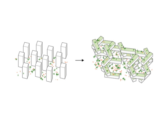
    His belief
    was that, yes, cities are and will continue to become more dense through tall
    buildings, but that most towers isolate rather than connect people. His work strives to do the opposite.

    And this
    one of the big trends that I think we will see more of in our cites. We will see
    new forms of urban connectedness and a blurring of private, public, and
    semi-public spaces. Screw Euclidean zoning.

    On that
    note, I am reminded that I owe the ATC community a post on my predictions for
    2016. I hope to get that out shortly.

    Diagram via Büro Ole Scheeren

  • Urban population densities, compared

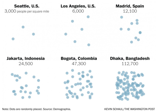
    Earlier this month The Washington Post published an article called, There’s no such thing as a city that has run out of room.

    And what it was really about was that when we say there’s no more room (I guess people are saying this), we are really saying that we just don’t want to allow anyone else to become our neighbor. Because the reality is that urban population densities vary widely around the world. So how can you really call a place full?

    I’m not sure I feel this pain point as much as the author, but I always find population densities to be a fascinating topic. And accompanying the article was a tool – using data from Demographia – that allowed you to compare the population densities of various cities.

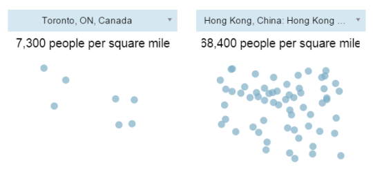
    Here are are two scenarios I ran:

    It’s important to keep in mind that these numbers are averages for the entire economically contiguous region. So it tells you nothing about the potential spikiness of certain areas. That’s why the population density of New York (which includes portions of New Jersey and Connecticut) probably seems low to you.

    Still, it’s fascinating to see how extreme some cities – including some first world cities like Hong Kong – can be. Clearly many cities have a lot of room to become a lot more dense. And I think that would be a good thing.

  • Mega-cities vs. networked cities

    Morning fog by Yijiang Wu on 500px.com

    https://500px.com/embed.js

    Ed Glaeser, Giacomo Ponzetto, and Yimei Zou recently published a new academic paper called, Urban Networks: Spreading the Flow of Goods, People and Ideas

    The paper looks at whether it’s more advantageous to build huge and consolidated mega-cities or build connected networks of smaller urban centers (perhaps connected by high speed rail). As countries like China rapidly urbanize, this is something that many people are thinking about.

    In China, there is a lively urban planning debate
    about whether to facilitate the increased expansion of the vast agglomerations of Beijing and
    Shanghai or whether to focus on creating networks of cities that are smaller, albeit still much
    larger than almost all of the cities of Western Europe. The current government policy favors
    networks, in the hope that connected smaller cities may be free of the extreme downsides of
    mass agglomeration, such as extreme congestion, pollution and high housing costs.

    Like most things, there are real trade-offs. 

    In the paper, they assume that larger cities lead to more urban amenities, which in turn serves as an important magnet for skilled workers. However, for unskilled workers who may not care/benefit from the same urban amenities, it is possible for them to dislike the bigger cities. In this case, the benefits do not outweigh the negatives of urban expansion and an urban divide is created (rich/poor).

    One of the potential negatives is housing.

    The attraction of denser, not larger, mega-cities is determined also by the elasticity of
    housing supply. When it is easy to add extra homes on a narrow plot of land, as in Texas,
    then density becomes more attractive. European urban networks may well be the right
    answer because history and regulation makes it so hard to build in Europe’s older cities.
    Even though China has usually been quite friendly towards skyscrapers, the sheer scale of
    the Chinese population may still make the case for urban networks.

    If you’re interested in this topic, there’s a section (#2) in the paper on the history of urban networks that you might like.

  • How urban density affects how you get around

    Yesterday I wrote about urban-suburban divides within cities. And I argued that built form will largely dictate the kinds of transportation choices that people will ultimately make.

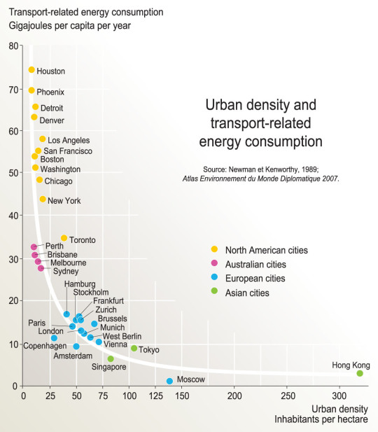
    As a follow-up to that, here is a chart based on the findings of a research report completed by Peter Newman and Jeffrey Kenworthy way back in 1989. On the x-axis is urban density (i.e. built form) and on the y-axis is per capita transport related energy consumption.

    image

    What this chart shows is that as cities become more dense, “automobile dependence” is reduced in favor of, other, more sustainable forms of transport. 

    Here we have Houston at the top left (meaning it has the highest transport-related energy consumption per capita) and Hong Kong all the way on the bottom right. Hong Kong has by far the highest density among the cities looked at in this study, but Moscow seems to have the lowest per capita energy consumption. Still, the trend appears clear.

    Some people think of “density” as a dirty word. But there are lots of benefits to dense urban centers. And density does not necessarily have to mean tall buildings.

    Chart: Globalization Studies in an Urban World (Penn)

  • 8 tips for building better cities

    Photograph Tram by Federico Venuda on 500px

    Tram by Federico Venuda on 500px

    My friend Alex Bozikovic of the Globe and Mail recently wrote a great article called: Expert advice on building the city of the 21st century. It’s a nice tie-in to a post I wrote a few weeks ago talking about the need for an urban agenda.

    For Alex’s article, the Globe asked “prominent urbanists, architects, and scholars” from around the world to comment on what Canadian mayors should be focused on right now as we build the cities of tomorrow.

    Here’s a list of what they said:

    1. Make people, not cars, happy
    2. Decrease speed limits
    3. Empower city governments
    4. Leverage density
    5. Embrace the science of big data
    6. Mix residences and workspace
    7. Turn streets into destinations
    8. Redevelop the inner suburbs

    It’s a great set of recommendations. So I would encourage you to check out the full Globe and Mail article.

  • Cities without ground

    image

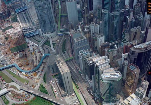
    The “ground plane” is an important reference in architecture. The ground is typically where people walk. The ground is where our fabricated buildings meet the earth. And the ground is where our experience of the urban environment–however good or bad it may be–truly takes shape. Often times I feel that we, city dwellers, spend far too much time worrying about the height of buildings and not enough time worry about the ground floor.

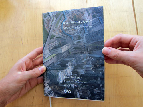
    But what if there were no clearly defined ground plane? This morning I stumbled upon an interesting book called, Cities Without Ground: A Hong Kong Guidebook. The authors call it “a manifesto for a new theory of urban form.” And the argument is that Hong Kong has developed a unique series of public/private spaces that allow it to function as a fully three-dimensional city. 

    image

    Through underground tunnels, above ground walkways, escalators, and other connective infrastructure, Hong Kong is reinventing the way we typically think about cities–both from a user experience and a real estate standpoint. Here’s an excerpt from the Guardian architecture and design blog:

    The phenomenon began in the 1960s, when the Hongkong Land company, one of the main developers in the region, built an elevated walkway to connect a luxury hotel to the second storey of an adjacent shopping mall. An insignificant move, perhaps, but it in fact had the effect of changing the rentable values within the building: suddenly the mall’s second floor units could be rented out for more than those at ground level. It entirely recalibrated the vertical logic of real estate value.

    Now, you could argue that Hong Kong is a unique place. And it is. Other, less dense cities, have found above and below grade walkways to be a destroyer of urban vibrancy. But in Hong Kong it works and, as many other cities around the world focus their energies on urban intensification, we may find that Hong Kong is indeed a new model for urban form.