Daily insights for city builders, delivered every morning at 6 AM ET. I’m Brandon Donnelly — a Toronto-based real estate developer and founder of Globizen. I’ve been writing here since 2013.

Tag: uli

  • The resilient story of Toronto’s tall towers

    The Urban Land Institute Toronto is hosting an event and panel discussion on April 8, 2021 about the future of high-rises in our cities. Here’s the blurb:

    Against the backdrop of the pandemic and its toll, what is the future of high-rises in our cities? What role do tall towers now play in shaping Toronto’s identity? While the pandemic has accelerated existing large trends, residential tall towers are proving the durability of a quality urban centre and hyper-urban lifestyles in Toronto and around the world.

    An introduction will be provided by James Parakh (author, Fellow of the Council on Tall Buildings and Urban Habitat, and Urban Design Manager for the Toronto & East York District) and then a discussion will be moderated by Robyn Player (Director, BTY).

    The discussion will be focused on what ULI is calling three of Toronto’s most exciting tower projects under development: Pinnacle One Yonge, One Delisle, and 11 Yorkville.

    I will be on the panel (talking One Delisle) alongside Lee Koutsaris (VP, Sales and Marketing, Metropia) and Anson Kwok (VP, Sales and Marketing, Pinnacle International).

    If you’d like to register, you can do that over here. It should be a great/timely conversation.

  • Where developers won’t build even with $0 land

    Building on yesterday’s post about inclusionary zoning, below is a telling diagram from the Urban Land Institute showing which areas of Portland can support new development and which areas cannot. To create this map, ULI looked at achievable rents in each US census block to determine, quite simply, where rents will cover the cost of new development (all types of construction).

    However, in their models they are also assuming a land value of $0. And typically people want you to pay them money when you buy their land. So in all likelihood, this map is overstating the amount of blue — that being land where new development is feasible.

    But it does tell you something about developer margins. A lot of people seem to assume that the margins on new developments are so great that things like inclusionary zoning can simply be “absorbed” without impacting overall feasibility. The reality is that there are large swaths in most cities where development is never going to happen even if you were to start handing out free land.

    This map is also helpful at illustrating some of the impacts of IZ. If you assume that rents are the highest in the center of the city and that they fall off as you move outward, then the outer edge of the above blue area is going to be where development is only marginally feasible. And so any new cost imposed on development would naturally start to uniformly eat away at the blue feasible area — that is, until rents rise enough to offset it.

    Of course, this is a simplified mapping. Land usually costs money. Land values might also be highest in the center and fall off as you move outward, or there could be pockets of high-cost land. There may be more price elasticity in certain sub-markets compared to others. So the impacts of a new development cost may not play out as neatly as I outlined above.

    Regardless, there will be impacts, which is why I find this map telling even if it isn’t fully accurate or up to date. Maybe some of you will as well.

  • World’s most diverse city-region

    For those of you who aren’t going to be in Toronto next week, you can stop reading now and check back tomorrow. For the rest of you, next week is The Future Cities Canada Summit, which will be taking place from November 7 – 9. Full schedule, here.

    Day 1 equals the Urban Land Institute Symposium 2018, which is all about Toronto urbanism. The tagline is: “Explore the urban frontiers of North America’s fastest growing, and the world’s most diverse city-region.” 

    A big part of day 1 will be bus tours around the city. And one of those tours is going to be focused on Toronto’s laneways. I am a speaker on that tour and the bus will be stopping at Junction House to talk about the laneway houses that we plan to release as part of the project.

    But there’s much more to this summit than just laneway housing.

  • What to do about Hong Kong’s land supply problem?

    My friend Jeremiah shared this ULI article with me this morning, which talks about Hong Kong’s land supply problem. The interesting thing about this problem is that only 9.3 square miles of the city’s land (out of ~424 square miles) is actually developed (and about 60% of the region’s area is water). The rest has been preserved for parks, farmland, and so on. And that is certainly a remarkable characteristic of Hong Kong. It doesn’t take very long to escape its hyper-urbanism and be in the countryside.

    Preserving greenspace is of course vital. But at what point do population and growth pressures justify the unlocking of some of that land for development? This is the question that Hong Kong appears to be asking itself. At the same time, it is looking at developing other islands (such as Lantau, which I understand is a pretty lush place); reclaiming (i.e. creating) additional land; and positioning the city as part of a planned “Greater Bay Area.” 

    If it were up to you, how would you suggest that Hong Kong deal with these pressures? The city is already fairly adept at building up.

    Photo by Annie Spratt on Unsplash

  • ULI Hines Student Competition comes to Toronto

    I was speaking with a Penn (my alma mater) student this evening about career options in development and he mentioned to me that he recently participated in the 2018 ULI Hines Student Competition. He also mentioned that this year’s “study site” is in Toronto. (It’s the BMW Toronto dealership between the West Don Lands and East Harbor.)

    For those of you unfamiliar with the ULI Hines Competition, it’s an annual student competition (now in its 16th year) that encourages collaboration among “future real estate developers and the many allied professions, such as architecture, landscape architecture, historic preservation, engineering, finance, and others.” 

    Each year there is a real life study site and multi-disciplinary teams compete for $50,000. I participated in my 2nd year of graduate architecture school and we received honorable mention. So no $50,000, sadly. But it was a valuable experience and I would recommend it to any student who plans to be involved in the built environment after graduation.

    I am looking forward to seeing what the finalists come up with for this site. I think that the study site being in Toronto – and in particular this location – speaks to the momentum that has developed in this part of the city as a result of the West Don Lands, East Harbor, Sidewalk Toronto, and the various planned infrastructure investments. 

    Here is a copy of this year’s briefing materials.
    Good luck to all of the teams that participated.

  • 5 random charts related to cities and real estate

    I was reading through PwC and ULI’s 2016 Emerging Trends in Real Estate report this evening and a handful of charts stood out to me. They’re not all related to each other, which is why this blog post is called what it is. But I think you’ll find them relevant to many of the things we talk about on this blog.

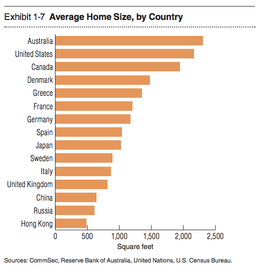
    1. Average home size by country

    With all the interest today in “small urban spaces” it’s interesting to see that the average home size for half the countries on this list is somewhere between 500 and ~1100 sf. It’s also amazing to see Hong Kong hovering just below 500 sf.

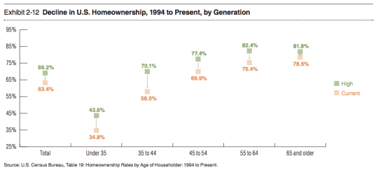
    2) The decline in homeownership in the US

    I like to follow home ownership rates because there’s a lot of debate around whether or not this obsession with homeownership – which has been so central to the ethos of countries like the US and Canada – is at all falling out of a favor. This chart shows some pretty significant drops from previous highs.

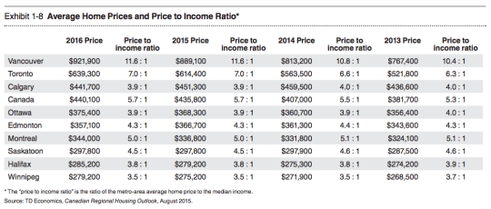
    3) Average home prices and the price to income ratio in major Canadian cities

    Not surprisingly, Vancouver and Toronto are the top of this list with the highest average home prices and the highest price to income ratios (i.e. the worst affordability).

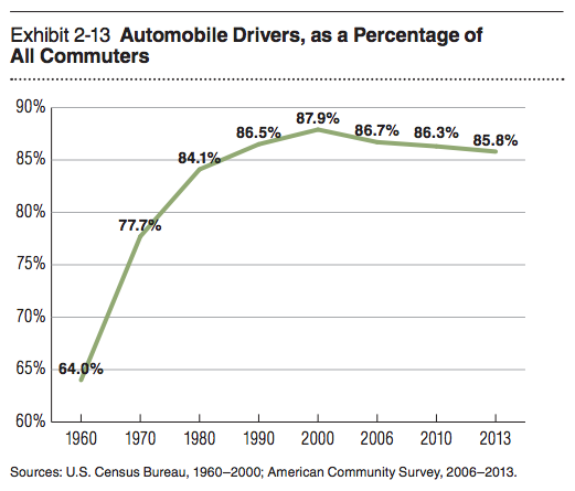
    4) Drivers as a percentage of all commuters in the US

    This chart is similar to what you would see if you looked at vehicle miles traveled. I’ve heard some people say that driving is now once again on the rise, but for the past decade and a half it’s been on a slow and steady decline.

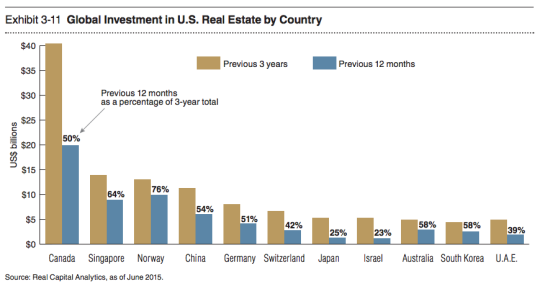
    5) Countries buying US real estate

    Canada is a big buyer of US real estate. But with the dollar where it is today, I am sure that number is headed downwards.

  • My #CityResolve

    Yesterday the Urban Land Institute here in Toronto launched a great social media initiative called #CityResolve. The idea is that instead of making a personal New Year’s resolution, that you instead make one that would benefit your city as a whole. This is great for me because I don’t really believe in New Year’s resolutions.

    You can read more about the initiative here, but all you have to do is tweet your resolve using #CityResolve. One person will be selected for a one-on-one meeting with Toronto’s Chief Planner, Jennifer Keesmaat – where you could then pitch your idea directly to the top 🙂

    For me though, I feel like I’ve already been acting on my resolve, which is this blog. When I started writing every day back in August 2013, I did so for myself, but also for a clear mission: To promote the building of beautiful, sustainable, and globally competitive cities. I don’t profess to have all the answers, but I hope to initiate the right kind of discussions.

    If that feels like a cop out though, here’s another:

    //platform.twitter.com/widgets.js

    What’s yours?

    Image: Flickr

  • Toronto’s Bloor-Danforth subway corridor is a land use crime scene

    image

    Yesterday after my post on leveraging LRT, I stumbled upon an interesting and timely article written by Richard Joy, who is the Executive Director of the Urban Land Institute (Toronto).

    The article talks about some of the transit-oriented development that we’ve seen at various nodes along Toronto’s Yonge subway corridor (St. Clair, Eglinton, Sheppard, and so on). But it goes on to argue that these are exceptions to the rule. For the most part, we’ve missed the boat:

    The tragic history of our massive capital investments into transit infrastructure is massive under-development.

    Indeed, the Bloor-Danforth subway corridor is a land use crime scene.

    His main argument is that until we expand the supply of transit-oriented land (through increased intensification), we will continue to undersupply the kinds of walkable and transit-oriented neighborhoods that many, if not most, people actually prefer. And that, out of necessity, will force people into their cars. Because affordability trumps location preference.

    As one example, he talks about the intersection of Bloor Street and Dundas Street in the west end of the city. Next to Union Station, this is probably the best connected mobility hub in the region. You have the Bloor-Danforth subway line, a streetcar line, and a GO regional rail line which all feed into it. Next year it’ll also become a stop for the new express train to Pearson airport.

    And yet the city has a history of opposing intensification in this location, including the old Giraffe Condominiums proposed by TAS. Does that make sense to you?

    Image: Flickr

  • My own study of the distribution of college graduates in the cities and suburbs of America’s metropolitan areas, conducted with my Martin Prosperity Institute colleagues Charlotta Mellander and Kevin Stolarick, finds the concentration of college grads in the urban core to be especially advanced in America’s largest metro areas. Metro areas with more than 3 million people have nearly twice the density of college grads in their center cities than those with populations of 1 million to 3 million. As metro areas grow larger and more congested, more highly educated and affluent people seek more-central locations. When the alternative is hours of commuting on crowded highways and gridlocked streets, more people are willing to trade their lawns, soaring cathedral ceilings, and multiple bathrooms for a more efficient, less car-dependent way of life.

    Richard Florida

  • Simply put, urban centers are no longer the poster children for decay and despair; they have, in fact, become the country’s economic engines.

    Richard Florida