Daily insights for city builders, delivered every morning at 6 AM ET. I’m Brandon Donnelly — a Toronto-based real estate developer and founder of Globizen. I’ve been writing here since 2013.

Tag: transportation planning

  • Cruise ships of urbanity

    There are many ways to describe one of the prevailing urban forms emerging across the Greater Toronto Area. You could call it spiky urbanism. You could call it a collection of peaks and plains. Or — as it is referred to in this recent article by Alex Bozikovic about “turning the suburb into the city” — you could call it cruise ship urbanity:

    These megaprojects are where Toronto has chosen to cram much of its new growth – “cruise ships of urbanity,” as Mr. Giannone told me, in a sea of houses. As such they provide an opportunity to create citylike density and activity.

    What we are talking about is a dichotomous form of urbanism: high-density mixed-use nodes surrounded by low-rise car-oriented communities. And on many levels, this makes a lot of sense, especially if the cruise ship happens to be docked on top of a transit station. This is where density needs to go. If you have a transit station without much density, that should be addressed immediately.

    But it also presents a great challenge. If transportation planning is necessarily land use planning, then we are dealing with two very different kinds of land use patterns and, therefore, two very different kinds of mobility demands. You can address this by making the cruise ship as self-sufficient and pleasant as possible, but eventually someone will want or need to get off the ship.

    Does that mean they will then need a car?

    You don’t have this same problem with more consistent forms of urbanism. Consider, for example, cities like Paris and Barcelona. These are dense cities, but more importantly they are, for the most part, uniformly dense. Or at least, uniformly dense enough. Meaning that you can probably apply a more uniform transportation strategy. What works in one part of the city is likely to work in other parts too.

    Of course, we could also apply a uniform transportation strategy to our urban cruise ships. Given that they exist in a sea of low-rise houses, we could simply say that each urban cruise ship resident should also have their own parking space (1:1 ratio). The solution: everyone drives! But this, to me, seems like an insane long-term solution.

    In my view, the most impactful solution lies not in the ships themselves, but in the seas surrounding them. We need to look holistically at our entire city region and determine what it will take to turn suburb into city. And that likely means a whole host of things, ranging from leveraging the infrastructure we already have (i.e. upzoning around transit stations) to embracing autonomous vehicles.

    In the end, I don’t think we want cruise ships of urbanity. We need more density, everywhere.

    Photo by mkdrone_ on Unsplash

  • New York City is piloting about a dozen motion sensor cameras

    This won’t come as a surprise to many of you. But I recently attended a community meeting where someone was advocating for adding new lanes to a particular road. Their argument was that traffic congestion is forcing too many cars to sit needlessly idle and that that is bad for the environment. The proposed solution of adding new lanes would get traffic moving, reduce idling pollution, and therefore be overall better for the environment.

    I disagree entirely.

    But transportation planning seems to be one of those things that many people feel is intuitive. It’s one of those things where people feel confident saying, “I know how to fix this. We just need to do this.” But the reality is that cities are incredibly complex organisms and it’s not always obvious what should be done. So I think that a big part of making our cities better comes down to having much better data. And that’s why I’m very intrigued by the work that startup Viva, and others, are doing.

    Viva uses small street-light mounted cameras and machine learning to track urban mobility (see image above). Currently they track 9 different modes: pedestrian, bicycle, e-scooter, motorcycle, car, van, light truck, semi-truck, and bus. And after they collect this data, the relevant information is extracted and then everything else is deleted for privacy reasons. There are also plans to make this data openly available to the public so that people can use it and/or build on top of it.

    Obviously this is still going to raise privacy concerns and that is something that will need to be carefully addressed. But I do think that the data from a platform like this is going to be invaluable for cities. Among many other things, it will help us to better allocate space among the various modes and design much safer streets. Hopefully it can also help to take some of the politics out of these sorts of decisions: “Here’s the data. Take a look.”

    Viva currently has 1,000 sensors already installed in London (where they are being used to evaluate the impacts of congestion pricing), and about half a dozen in New York. So it’ll be interesting to see what this leads to. And who knows, maybe it will actually turn us all into amateur transportation planners. We’ll certainly have access to a lot more data.

    For more information on Viva, here’s their website.

    Image: Viva

  • Manhattan is still looking at a congestion charge for south of 60th Street

    We talk a lot about congestion charges and road pricing on this blog. Here’s a list of some of those posts. I found 46 that were tagged with “road pricing.”

    I continue to believe that it’s the only way that big cities can effectively solve the problem of traffic congestion. It’s not being caused by the bicycle lanes that were just added to your street. It’s not the new COVID street patios. And it’s not the new apartment that was just built with too many parking spots.

    The problem is mispricing.

    If you want free roads, then you don’t get free-flowing traffic. That’s how this equation works, which is why I have always thought it a good idea to dynamically price roads based on demand, and then to direct those funds toward more efficient forms of mobility — such as transit.

    Despite all this, it’s not a very popular approach in this part of the world. Toronto looked at road pricing back in 2016, but we got nervous and backed away from it. New York City has also been looking at a congestion charge for Manhattan south of 60th Street for at least 4-5 years. But this one appears to still be on the table.

    According to this recent CityLab article, New York’s congestion prices could look something like this (note that this chart includes other pre-existing tolls):

    But with some exceptions (I think this is an interesting approach):

    Primary residents of the Manhattan central business district, which is south of 60th Street, and New York State residents with adjusted gross income of less than $60,000 would be eligible for a state tax credit equal to the amount of the new tolls, paid during the taxable year.

    In total, this current pricing scheme is expected to generate an additional $1 billion in annual revenue for the city’s transportation authority. The MTA also plans to bond against this revenue and raise an additional $15 billion for new transit projects.

    This sounds like a reasonable approach to me.

  • Slime mold may be better than us at transportation planning

    So slime mold, which is a fungus-like single-celled organism, has a tendency to build highly optimized networks across its food sources. In other words, if you scattered a bunch of food on a surface and then dropped in some slime mold, it would naturally create an interconnected web of linked veins across this surface. And this web would be based on the shortest and most efficient paths of travel between the various food sources.

    I am mentioning this odd factoid because ten years ago researchers in Tokyo used this naturally occurring phenomenon for the purposes of trying to improve transportation planning. What they did was map out greater Tokyo. They then placed oat flakes (i.e. food) in spots that correspond to the various cities and urban centers that surround the city. Alongside this, they blocked off the areas where transportation networks do not typically run, such as through mountains and into the water. They then dropped in some slime mold, wet the surface, and watched it grow.

    What they found was that the resulting network was remarkably similar to Tokyo’s actual rail network. The slime mold had found the most efficient routes, eliminated redundancies, and generally discovered the optimal way in which to connect its food sources. And if you think about it, this is basically what transit networks are supposed to do. They should connect clusters of people in the most efficient way possible.

    It has been a decade since this slime mold transportation discovery was first publicized, and it would seem that it hasn’t really caught on as an invaluable planning tool. So I’m going to go out on a limb and suggest that we should take out a map of every major city in the world, plot its population centers, drop down some oat flakes, and then let slime mold tell us all the ways in which we are screwing up and over-politicizing our transportation planning efforts.

    Thank you to Angus Knowles for making me aware of this study. Angus writes an occasional newsletter about cities and housing, over here.

    Image: LiveScience

  • The Scarborough Subway Extension is a mistake

    Last weekend over dinner, a friend of mine asked me what I thought about the Scarborough Subway Extension debate going on in Toronto right now. Costs are coming in higher than initially projected and the usual back and forth is taking place. Transit blogger Steve Munro has a good post on this called Spinning a Tale in Scarborough.

    I haven’t written much about the Scarborough Subway, but I do have a strong opinion. I believe it’s a mistake. I am not saying that we shouldn’t be building higher order transit in Scarborough – we absolutely should – but it does not need to be an expensive subway line. There are more sensible solutions.

    Here are a few things to consider:

    Light rail transit (LRT) does not equal streetcar. As an avid user of the King streetcar, I’ll be the first to admit that something needs to be done to address the city’s busiest streetcar routes. They are broken. But this is not what was being previously contemplated for Scarborough. True LRT – which Toronto does not yet have – is far more effective at moving people.

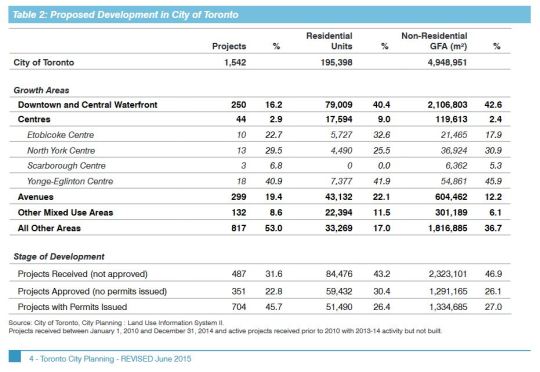
    Scarborough Centre is seeing almost no new residential and commercial development. In fact, the “Centres” in general are not seeing much development. The largest share is happening downtown, along the central waterfront, and along the “Avenues.” We shouldn’t ignore this when making our investment decisions. Transit and built form go hand in hand. 

    I also do not buy the argument that we are building this subway in anticipation of demand 50 or 100 years from now. We are not in a position to be proactive about our infrastructure. We are desperately playing catch up and there are already lots of high growth and high density areas in the city which today are completely underserved by higher order transit. 

    Finally, a new subway line with low ridership will mean higher operating cost subsidies to keep it afloat. And at the rate that Scarborough Centre is growing today, this would likely continue for many years into the future. Not only is this debate about spending money today, it is about spending money well in the future, month after month.

    So let’s be clear: the Scarborough Subway Extension debate is about politics. It is not about transportation planning.