Daily insights for city builders, delivered every morning at 6 AM ET. I’m Brandon Donnelly — a Toronto-based real estate developer and founder of Globizen. I’ve been writing here since 2013.

Tag: transit

  • Ridesharing could help solve the last mile problem

    X by Keith Mokris on 500px.com

    https://500px.com/embed.js

    A few months ago I wrote a post about Uber’s new “Smart Routes” feature and ended by saying that it’s not just taxis who need to be thinking about platforms like Uber, it’s also public transit authorities.

    I said that because I think that multi-modal is already the new reality in terms of how we get around cities and because the line between different modalities is becoming greyer all the time.

    That’s why I was interested when I stumbled upon this NextCity article talking about how Lyft is starting – it’s still early days – to collaborate with transit authorities in order to make it easier for people to switch between public transit and its peer-to-peer ridesharing marketplace.

    Why might this matter? Here’s an excerpt from the article:

    “According to the company’s data, 25 percent of Lyft riders say they use the service to connect to public transit. In Boston, 33 percent of those rides start or end near a T station. And transit hubs like Chicago’s Union Station, D.C.‘s Union Station and Boston’s South Station are among the most popular destinations for its users, Lyft finds. So riders already see on-demand rides as a solution to the first mile/last mile problem. Lyft thinks it can do more.”

    These last 2 sentences are interesting. Public transit can often suffer from what is known as the first mile/last mile problem. This is a problem where riders find it difficult to get to the nearest transit route from their departing point or to their ultimate destination once they exit transit.

    Bikesharing can be used to solve this. But, clearly, so can ridesharing.

    The other important aspect of this emerging collaboration is that ridesharing apps can offer a lot of incredibly valuable data to transit authorities. If 25% of users are indeed using it to connect to public transit, then all of a sudden cities are getting a more complete picture of point A to B travel. (Among many other things.)

    But the question in my mind is now, who is going to and who should act as the overall steward in this multi-modal urban mobility network? 

    There are lots of different players involved. Some are public and some are private. But they all play a role in how we are going to continue moving around our cities.
  • How we perceive commuting

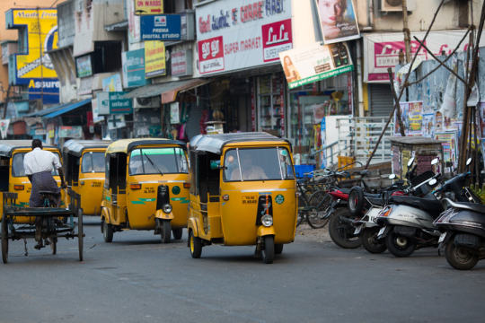
    CHENNAI, INDIA-FEBRUARY 10: Street of Indian city 10, 2013 in Ch by sergemi on 500px.com

    https://500px.com/embed.js

    Wharton real estate professor, Mariaflavia Harari, recently published a paper that looks at the relationship between urban geometry (specifically compactness) and inner city commuting efficiency across 450 cities in India.

    Consistent with previous research done in this space, she finds that people generally prefer compact cities and that they are willing to pay a premium for it. It increases overall welfare. Here’s an excerpt from her paper:

    “My findings are broadly consistent with compact city shape being a consumption
    amenity. All else being equal, more compact cities grow faster. There is also evidence that
    consumers are paying a premium for living in more compact cities, in terms of lower wages and,
    possibly, higher housing rents.”

    So her recommendations for the Indian cities she analyzed was that they should relax land use restrictions to allow for more vertical / compact development and that they should focus on improving urban transport in order to offset some of the negatives externalities associated with sprawl. This is no different than the approach that many cities in the developing world are adopting or looking to adopt.

    One of things that really stood out for me in her paper though is the way people perceive commuting:

    “The loss associated with non-compact
    shape appears to be substantial: a one-standard deviation deterioration in city shape, corresponding
    to a 720 meter increase in the average within-city round-trip, entails a welfare loss
    equivalent to a 5% decrease in income. This is considerably larger than the direct monetary and
    opportunity cost associated to lengthier commutes. Less compact cities also appear to attract
    fewer low-income immigrants, as captured by the share of slum dwellers.”

    What this is saying is that we tend to overvalue the negatives of commuting, beyond the direct costs of gas, insurance, car payments, our time, and so on. We hate it so much that we also want to be compensated for the mental anguish. Here is that same idea said differently:

    The estimated welfare loss from longer commutes appears to be large, relative to the immediate
    time and monetary costs of commuting. This is consistent with the interpretation that
    commuting is perceived as a particularly burdensome activity. The behavioral literature has
    come to similar conclusions, albeit in the context of developed countries. Stutzer and Frey
    (2008) find a large and robust negative relation between commuting time and subjective wellbeing,
    using German data. They estimate that individuals commuting 23 minutes one way
    would have to earn 19 percent more per month, on average, in order to be fully compensated.

    So I guess I’m not the only one who thinks commuting and driving sucks.

  • How to encourage traffic congestion in your city

    City
    Observatory recently republished their
    commentary
    on a report (released earlier this year) called Who Pays
    for Roads
    . I missed their original post, so this is new to me.

    The report
    and commentary are all about the mispricing of roads/driving and the fallacy
    that “user fees” (gas taxes, tolls, and so on) are enough to completely cover
    the costs associated with driving.

    I have been
    a vocal supporter of road pricing and/or congestion charges here in Toronto, and
    so I’d like to share two pieces from their commentary.

    The first
    is this paragraph, which talks about how mispricing leads to demand issues
    (i.e. traffic congestion):  

    The conventional
    wisdom of road finance is that we have a shortfall of revenue: we “need” more
    money to pay for maintenance and repair and for new construction. But the huge
    subsidy to car use has another equally important implication: because user fees
    are set too low, and because, in essence, we are paying people to drive more,
    we have excess demand for the road system. If we priced the use of our roads to
    recover even the cost of maintenance, driving would be noticeably more
    expensive, and people would have much stronger incentives to drive less, and to
    use other forms of transportation, like transit and cycling. The fact that user
    fees are too low not only means that there isn’t enough revenue, but that there
    is too much demand. One value of user fees would be that they would discourage
    excessive use of the roads, lessen wear and tear, and in many cases obviate the
    need for costly new capacity.

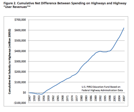
    And the second is this chart, which shows the cumulative net
    subsidy to highways in the US from the late 1940’s:

    image

    The point of all this is that when you subsidize something
    it’s because you’d like to see more, not less of it. So why then are we even surprised by the crippling traffic that plagues our
    cities? We are doing a lot to encourage exactly that.

  • The London Crossrail

    On Thursday afternoon the mayor of Toronto, John Tory, was in London meeting with their mayor, Boris Johnston, and talking about Toronto-London business relations, the economy, and transit.

    Here is the tweet:

    //platform.twitter.com/widgets.js

    On the topic of transit, the big item to see and discuss was The Crossrail. For those of you who might not be familiar with it, here are a few bullet points from their website:

    Crossrail is Europe’s largest construction project – work started in May 2009 and there are currently over 10,000 people working across over 40 construction sites.

    The Crossrail route will run over 100km from Reading and Heathrow in the west, through new tunnels under central London to Shenfield and Abbey Wood in the east.

    Crossrail will transform rail transport in London and the south east, increasing central London rail capacity by 10%, supporting regeneration and cutting journey times across the city.

    Crossrail will bring an extra 1.5 million people to within 45 minutes of central London and will link London’s key employment, leisure and business districts – Heathrow, West End, the City, Docklands – enabling further economic development.

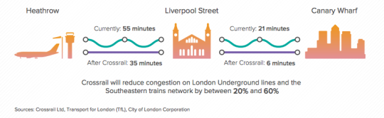
    And below is a neat diagram that I found in this City of London report. I think it does a good job summarizing some of the spatial impacts of The Crossrail.

    image

    In the past I’ve been negative about John Tory’s SmartTrack proposal, which is clearly inspired by The London Crossrail. I had my reasons for that. But I want to be clear that I am not in any way negative on Regional Express Rail as a mobility solution.

    Toronto would benefit greatly from RER and Metrolinx is working diligently to deliver it to the region. I can’t wait for that to happen so I can drive even less than I already do.

  • We are all selfish bastards

    cyclist on bike lane by Axel Bueckert on 500px.com

    https://500px.com/embed.js

    We are all selfish bastards when it comes to sharing road space and public space.

    When we drive, we complain about pedestrians jumping out in front of us, crazy cyclists who get in our way, and under-utilized bike lanes that are taking away valuable driving space and creating traffic jams.

    When we take surface transit (such as buses and streetcars), we want all the cars out of the way so that we can move more efficiently. And we complain about drivers who don’t stop to let us off and on when the streetcar doors open. (Toronto specific reference.)

    When we cycle, we complain about cars parked in the bike lanes, people who don’t look before changing lanes or opening their car doors, and drivers who honk at you because they just want you off the road and onto the sidewalk.

    And when we walk, we complain about cyclists who ride on the sidewalk (they should be on the road!), cars that don’t stop to let us go, and slow walking groups who linearly block the entire sidewalk so you can’t pass.

    We are never happy. And we automatically assume that we could do it better. (I know I’m guilty of this.)

    But here are a few things to consider the next time you’re flipping the bird to someone on the streets. Here are a few things that we do know about urban mobility.

    There is an unprecedented number of condominiums in the development pipeline right now in Toronto. For argument’s sake, let’s assume 75,000 condominium suites – many of which will be built in central areas of the city.

    At a parking ratio of 0.6 stalls per unit, which isn’t an unreasonable assumption today, that’s 45,000 new parking spots and potentially 45,000 new cars in the city. 

    If you think that 45,000 new cars will be able to get fully absorbed into the core and somehow move around in an unfettered way, then I believe you are mistaken. 

    If you think that there’s something that can be done to magically expand road capacity to handle all of these additional cars in the city, then I believe you are mistaken.

    And if you think that adding a bike lane is the only reason you are currently stuck in traffic, then I believe you are missing the bigger picture.

    Over a decade ago, we made a decision in this region to encourage building up, instead of building out. And along with that decision came a necessary rethink of how we get around. That transition is what we are living through right now.

    The other thing we know is that the 4 modes of mobility that I started this post with are ordered from least sustainable to most sustainable. 

    Electric self-driving vehicles will reduce the impacts of driving, but it will also transform it into something that feels more like transit and less like the driving we know today. That will be a very good thing.

    But I’m not yet convinced that it will solve all of our problems. To do that I think we will need to adopt a much more balanced and unselfish view of what it takes to move around a city. That, of course, isn’t always easy.

  • From map books to Google Maps

    When I was a kid I remember my parents having something called a “Perly’s” in their car. It was basically a map book and it was the best thing around. 

    You would start by looking at a big grid of the city and then you’d find the specific area you were looking for and then flip to that page. If you were on the road a lot for work, a Perly’s was a mandatory addition to your car.

    Things have obviously come a long way since then. It could take you a long time to find the street you were looking for in a Perly’s. I remember doing that from the passenger seat. Now our phones do that for us and if the connection makes us wait for more than few seconds, we get irritated.

    But we’ve also moved beyond just static maps. 

    The other morning I was driving out to the suburbs and I saw this road sign telling me that – given current traffic conditions – it was going to take me 15 minutes to get to HWY 427. 

    image

    Have you ever wondered how they come up with those time estimates?

    There are a few ways to do it. But here in Toronto along the Gardiner Expressway and Lake Shore Boulevard it’s done using your mobile phone. Phones have unique network identifiers called MAC addresses. And when they try and connect via Bluetooth or Wifi they actually send out their MAC address.

    So what happens as you’re driving along is that your phone’s MAC address is being picked up at various locations. And since the distance between these various reception points is known, it’s pretty easy to determine how fast you’re traveling. That’s how they come up with those time/traffic estimates. 

    This data is anonymous but, in theory, the city also knows if people are speeding when the traffic is light.

    This same technology is being used by many retailers and shopping malls to track how people move through their spaces. It’s used to see, among other things, which merchandising strategies are working and what synergies one might be creating (or not creating) with the tenant mix.

    But getting back to traffic, there are obviously ways to collect traffic data without any additional physical infrastructure.

    As I was about to leave the suburbs and head back downtown, my phone somehow knew I was about to do that (perhaps because I was stopped at a Starbucks near the highway) and so it decided to tell me this:

    image

    It wasn’t the best notification to receive on my phone, but I was impressed nonetheless. This traffic data is collected using GPS data transmitted from mobile phones using Google Maps, Apple Maps, and so on. Clearly we’ve come a long way since the days of manually leafing through a thick Perly’s.

    At the same time, it feels like we are still pretty far away from solving the problem of urban congestion. Every big city in the world is grappling with this issue

    Part of the problem, I think, is the belief that there’s some sort of silver bullet – more highways, a magic smartphone app, and so on – that will enable everyone to be able to drive around in their own car by themselves. I don’t believe that’s possible in big cities. And the sooner we get away from that toxic thinking, the quicker we’ll solve this problem.

  • How to save 8 minutes on Toronto’s highways

    City in Colour by Greg Patterson on 500px.com

    https://500px.com/embed.js

    Three months ago when Toronto City Council voted
    not to remove the Gardiner Expressway
    East (which in
    my view was a mistake
    ), it did so with a commitment to look at tolling
    options for both the Gardiner Expressway and the Don Valley Parkway (which in
    my view is a positive thing
    ).

    Last week a preliminary report was released
    discussing some of those tolling options. If reading dry city reports is your thing,
    you can do that here.

    The Coles Notes version (CliffNotes for you
    Americans) is that a $3 flat toll on both the Gardiner and the DVP – the same
    cost as riding transit in this city – would be expected to reduce vehicles on the highways by 9% and 12%, as well reduce end-to-end travel times by 3 minutes and 5
    minutes, respectively. There’s obviously a lot more in the report, but these
    figures stood out for me.

    Given how monumental the
    3 minute delay
    was in the Gardiner East debates, it will be interesting to
    see whether people treat a 3 minute time savings in a similar way. I suspect
    they won’t. The cost will be the larger issue.

    I’ve been a
    vocal supporter of tolls and road pricing on this blog
    . One of the main reasons
    for that is because I view the demand for highways as being largely inelastic
    and therefore a potentially great source of transit funding.

    The discouraging part of the above report is
    that its primary goal is to explore tolls for the purpose of “offsetting
    capital, operating, and maintenance costs.” The primary goal is not to come up
    with sustainable sources of transit funding.

    Having these costs paid for by user-fees as
    opposed to general taxes is still a good thing in my view. But an even better thing
    would be to help fund mobility solutions that we know will be far more
    effective at getting people around this region as millions more people move here
    in the coming decades.

    The other discouraging part of the report is
    that near the end it explains that while the City of Toronto Act of 2006 allows
    for toll highways, they cannot be implemented without the Province passing
    regulation.

    It’s a reminder that our governance structures do
    not reflect the current urban reality of this country.

  • Uber, commuting, car ownership, and the future of urban mobility

    Earlier this week I wrote a “Tech Tuesday” post talking about Uber’s new Smart Routes functionality, which it is currently testing out in San Francisco. At the end of the post I ended by saying that it’s not just the taxi industry that should be thinking about Uber, it’s also public transit authorities. 

    And that’s because many people in cities rely on multi-modal forms of transportation (I know I do) and in my mind it is clear that Uber is trending away from just “Everyone’s Private Driver” to a service that is starting to look and feel a lot like urban mass transit.

    Then today my good friend Evgeny sent me a post called, “Public Transit Should Be Uber’s New Best Friend.” And it’s one of the best pieces I’ve read on Uber and its impact on urban mobility. I highly recommend you give it a read, particularly if you’re in the city building arena.

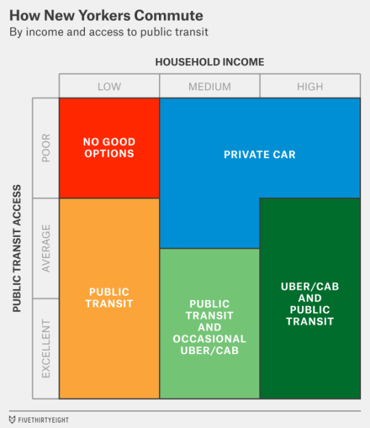
    The article does a deep dive into how New Yorkers commute. Here’s how they broke it down.

    image

    It then talks about what it will take for a company like Uber to make a meaningful dent in car ownership (which is one of the company’s goals) and how the truly big opportunity for Uber is to go more mass market and tap into the public transit market – either by interfacing with or by building its own version of it.

    Here’s their concluding paragraph:

    But there’s a much wider potential audience if Uber can also reach middle-class customers who want to save money. Perhaps in the distant (or even the not-so-distant) future, Uber can build its own version of “public” transit, making rides so cheap that they cost less than the $4 or $5 that Americans now pay, on average, to make a trip in their personal cars. In the meantime, it might have more success among “car-cutting” customers who can use Uber along with public transit. That might mean Uber’s growth is concentrated more in cities like New York, San Francisco and Chicago — and in Europe and Asia — that already have reasonably strong public transit networks.

    It’s definitely worth a full read. Thanks again for sending this over Evgeny.

  • How urban density affects how you get around

    Yesterday I wrote about urban-suburban divides within cities. And I argued that built form will largely dictate the kinds of transportation choices that people will ultimately make.

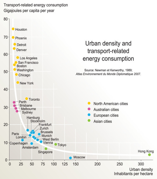
    As a follow-up to that, here is a chart based on the findings of a research report completed by Peter Newman and Jeffrey Kenworthy way back in 1989. On the x-axis is urban density (i.e. built form) and on the y-axis is per capita transport related energy consumption.

    image

    What this chart shows is that as cities become more dense, “automobile dependence” is reduced in favor of, other, more sustainable forms of transport. 

    Here we have Houston at the top left (meaning it has the highest transport-related energy consumption per capita) and Hong Kong all the way on the bottom right. Hong Kong has by far the highest density among the cities looked at in this study, but Moscow seems to have the lowest per capita energy consumption. Still, the trend appears clear.

    Some people think of “density” as a dirty word. But there are lots of benefits to dense urban centers. And density does not necessarily have to mean tall buildings.

    Chart: Globalization Studies in an Urban World (Penn)

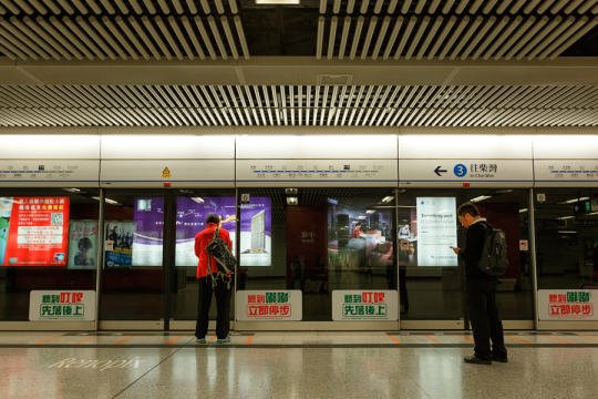
  • With Vancouver voting “no” to transit tax, could Hong Kong now serve as inspiration?

    https://500px.com/embed.js

    Earlier today it was announced that Metro Vancouver voted “no” to a 0.5% sales tax increase that would have been used to fund a $7.5 billion regional transportation plan. 

    Roughly 62% of respondents said “no”. And not surprisingly, the percentage of people who voted “no” increased as you moved outward towards the suburbs. But even the City of Vancouver itself sided slightly with “no” at 50.81%.

    Since I’m not that plugged into the Vancouver scene, I’m not going to comment on this issue. But hopefully you all will in the comments below. I know that a lot of you are incredibly passionate about this.

    Instead, I’d like to pose two questions. 

    Firstly, why is it that Asian transit operators seem to be so much better than North American transit operators at recovering their costs through fares? (Urban density and car ownership likely have something to do with it). And secondly, why hasn’t Hong Kong’s famous “rail plus property” transit model been exported to North America?

    For those of you unfamiliar with Hong Kong’s Mass Transit Railway Corporation, here’s how much money they make (via The Atlantic from 2013):

    The Mass Transit Railway (MTR) Corporation, which manages the subway and bus systems on Hong Kong Island and, since 2006, in the northern part of Kowloon, is considered the gold standard for transit management worldwide. In 2012, the MTR produced revenue of 36 billion Hong Kong Dollars (about U.S $5 billion)—turning a profit of $2 billion in the process. Most impressively, the farebox recovery ratio (the percentage of operational costs covered by fares) for the system was 185 percent, the world’s highest. Worldwide, these numbers are practically unheard of—the next highest urban ratio, Singapore, is a mere 125 percent.

    In addition to Hong Kong, the MTR Corporation runs individual subway lines in Beijing, Hangzhou, and Shenzhen in China, two lines in the London Underground, and the entire Melbourne and Stockholm systems. 

    And here’s how they do it (also via The Atlantic):

    Like no other system in the world, the MTR understands the monetary value of urban density—in other words, what economists call “agglomeration.” Hong Kong is one of the world’s densest cities, and businesses depend on the metro to ferry customers from one side of the territory to another. As a result, the MTR strikes a bargain with shop owners: In exchange for transporting customers, the transit agency receives a cut of the mall’s profit, signs a co-ownership agreement, or accepts a percentage of property development fees. In many cases, the MTR owns the entire mall itself. The Hong Kong metro essentially functions as part of a vertically integrated business that, through a "rail plus property” model,  controls both the means of transit and the places passengers visit upon departure.  Two of the tallest skyscrapers in Hong Kong are MTR properties, as are many of the offices, malls, and residences next to every transit station (some of which even have direct underground connections to the train). Not to mention, all of the retail within subway stations, which themselves double as large shopping complexes, is leased from MTR.

    I believe that we could do this too. So hopefully we can have a great discussion about it in the comment section below.