Daily insights for city builders, delivered every morning at 6 AM ET. I’m Brandon Donnelly — a Toronto-based real estate developer and founder of Globizen. I’ve been writing here since 2013.

Tag: traffic

  • Slot-based intersections

    If you don’t follow the work of MIT’s Senseable City Lab, I highly recommend that you start. 

    Earlier this year, researchers from the Massachusetts Institute of Technology, the Swiss Institute of Technology, and the Italian National Research Council developed something that they call “slot-based intersections.” In a world where cars have sensors and drive themselves, it is intended as a more efficient alternative to traditional intersections. Goodbye traffic lights.

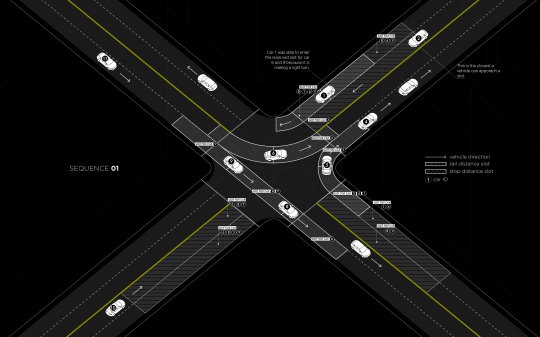
    Much like air-traffic control, the way the system works is by assigning individualized time slots to each car for when they may enter an intersection. For example, in the diagram below (Sequence 01) the car approaching from the bottom left (#10) has a “stop distance slot” in front of it reserved for 3 of the cars that are currently in the intersection. The two that are traveling perpendicular to it and the car currently turning left into the same lane as #10 (on the other side of the intersection). The car in the midst of turning right (#5) is exempt because there’s no possibility of collision. 

    image

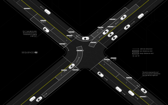
    In Sequence 02 (below) you can see that car #10 is now turning left, which means it has its own time slot in the intersection. Other approaching cars now have a “stop distance slot” dependent on car #10.

    image

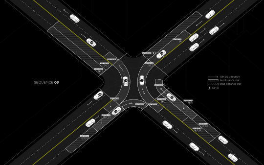
    In all cases, cars making a right turn are able to move freely, provided they will not interfere with any other cars.

    image

    The researchers estimate that real-time slot allocation might double the number of vehicles that a traditional traffic-light intersection can handle today and, in some cases, it might completely eliminate stop and go traffic.

    Often when I write about self-driving vehicles I hear people tell me that cars are still cars. It doesn’t matter whether they are self-driving or not. The same inefficiencies apply. They are not the solution to urban gridlock. Elon Musk was also criticized (following his Master Plan) for not properly understanding urban geography.

    But self-driving cars will create new efficiencies. I am not saying that they are a silver bullet, but I am saying that they will help a great deal. I don’t think that anyone truly understands the extent of these efficiencies, but there are a myriad of possibilities. This Senseable City Lab project is a perfect example.

    What I am grappling with right now is the relationship between self-driving vehicles and traditional forms of public transit. Until we get a handle on the efficiencies and overall impact, it’s hard to ascertain how these different forms of mobility will work together. My gut tells me that the lines are bound to get blurry and that self-driving “cars” will feel less and less like the cars we know today.

    Below is a video that was published along with the research. If you can’t see it, click here.

    [youtube https://www.youtube.com/watch?v=4CZc3erc_l4?rel=0&w=560&h=315]

  • Rethinking downtowns to improve urban mobility

    Jarrett Walker of Human Transit recently published an interesting post talking about downtowns. His argument is that we shouldn’t be planning our transit networks around the traditional notion of a single-centered city.

    Here’s a snippet:

    So growing a single downtown isn’t the key to becoming a great transit city. Quite the opposite, it’s best to have a pattern of many centers, all generating high demand, and supporting balanced two-way flows between them that let us move more people on less infrastructure.  This is the great advantage of Paris or Los Angeles or the Dutch Randstad over Chicago or Manhattan.

    Now, there are many cases where a singular economic center still dominates an urban region. See downtown Toronto. And many will argue that the current economic environment is creating more, rather than less, concentrated urban spikiness.

    But at the same time it is quite clear that many of our cities have shifted away from a monocentric model to a polycentric one. 

    I mean, just look at all employment nodes that have developed across the Toronto region. The idea that everyone comes downtown in the morning and then leaves in the evening has become an anachronism for many. Early in my career I spent 4 years commuting from downtown to the suburbs.

    So what is happening is that our cities need to start performing more like point-to-point networks. This isn’t a new thought. But it’s a lot harder to execute on compared to what many cities have been used to. 

    You need a critical density of both residents and employers and the right kind of connectivity to create a true “mobility hub.” In Toronto, you could argue that we really only have one of those and it’s centered around Union Station.

    But I think that will change for many cities. And when we do get it right, we will be doing a lot to improve the crippling traffic congestion that so many of our cities are suffering from.

  • How to encourage traffic congestion in your city

    City
    Observatory recently republished their
    commentary
    on a report (released earlier this year) called Who Pays
    for Roads
    . I missed their original post, so this is new to me.

    The report
    and commentary are all about the mispricing of roads/driving and the fallacy
    that “user fees” (gas taxes, tolls, and so on) are enough to completely cover
    the costs associated with driving.

    I have been
    a vocal supporter of road pricing and/or congestion charges here in Toronto, and
    so I’d like to share two pieces from their commentary.

    The first
    is this paragraph, which talks about how mispricing leads to demand issues
    (i.e. traffic congestion):  

    The conventional
    wisdom of road finance is that we have a shortfall of revenue: we “need” more
    money to pay for maintenance and repair and for new construction. But the huge
    subsidy to car use has another equally important implication: because user fees
    are set too low, and because, in essence, we are paying people to drive more,
    we have excess demand for the road system. If we priced the use of our roads to
    recover even the cost of maintenance, driving would be noticeably more
    expensive, and people would have much stronger incentives to drive less, and to
    use other forms of transportation, like transit and cycling. The fact that user
    fees are too low not only means that there isn’t enough revenue, but that there
    is too much demand. One value of user fees would be that they would discourage
    excessive use of the roads, lessen wear and tear, and in many cases obviate the
    need for costly new capacity.

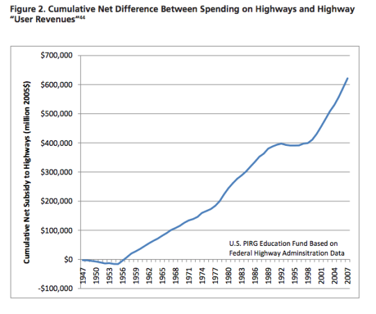
    And the second is this chart, which shows the cumulative net
    subsidy to highways in the US from the late 1940’s:

    image

    The point of all this is that when you subsidize something
    it’s because you’d like to see more, not less of it. So why then are we even surprised by the crippling traffic that plagues our
    cities? We are doing a lot to encourage exactly that.

  • From map books to Google Maps

    When I was a kid I remember my parents having something called a “Perly’s” in their car. It was basically a map book and it was the best thing around. 

    You would start by looking at a big grid of the city and then you’d find the specific area you were looking for and then flip to that page. If you were on the road a lot for work, a Perly’s was a mandatory addition to your car.

    Things have obviously come a long way since then. It could take you a long time to find the street you were looking for in a Perly’s. I remember doing that from the passenger seat. Now our phones do that for us and if the connection makes us wait for more than few seconds, we get irritated.

    But we’ve also moved beyond just static maps. 

    The other morning I was driving out to the suburbs and I saw this road sign telling me that – given current traffic conditions – it was going to take me 15 minutes to get to HWY 427. 

    image

    Have you ever wondered how they come up with those time estimates?

    There are a few ways to do it. But here in Toronto along the Gardiner Expressway and Lake Shore Boulevard it’s done using your mobile phone. Phones have unique network identifiers called MAC addresses. And when they try and connect via Bluetooth or Wifi they actually send out their MAC address.

    So what happens as you’re driving along is that your phone’s MAC address is being picked up at various locations. And since the distance between these various reception points is known, it’s pretty easy to determine how fast you’re traveling. That’s how they come up with those time/traffic estimates. 

    This data is anonymous but, in theory, the city also knows if people are speeding when the traffic is light.

    This same technology is being used by many retailers and shopping malls to track how people move through their spaces. It’s used to see, among other things, which merchandising strategies are working and what synergies one might be creating (or not creating) with the tenant mix.

    But getting back to traffic, there are obviously ways to collect traffic data without any additional physical infrastructure.

    As I was about to leave the suburbs and head back downtown, my phone somehow knew I was about to do that (perhaps because I was stopped at a Starbucks near the highway) and so it decided to tell me this:

    image

    It wasn’t the best notification to receive on my phone, but I was impressed nonetheless. This traffic data is collected using GPS data transmitted from mobile phones using Google Maps, Apple Maps, and so on. Clearly we’ve come a long way since the days of manually leafing through a thick Perly’s.

    At the same time, it feels like we are still pretty far away from solving the problem of urban congestion. Every big city in the world is grappling with this issue

    Part of the problem, I think, is the belief that there’s some sort of silver bullet – more highways, a magic smartphone app, and so on – that will enable everyone to be able to drive around in their own car by themselves. I don’t believe that’s possible in big cities. And the sooner we get away from that toxic thinking, the quicker we’ll solve this problem.

  • The tragedy of the commons

    https://500px.com/embed.js

    In 1968, Garrett Hardin wrote an article where he coined the term: the tragedy of the commons. Hardin was an American ecologist who was obsessed and concerned with the prospect of human overpopulation.

    In his article, the term tragedy of the commons was used to describe a situation where individuals – all acting independently and in their own self-interest – actually end up behaving in a way that is detrimental to the larger group and that negatively impacts some sort of common resource.

    Just in case, here’s another definition via Investopedia:

    An economic problem in which every individual tries to reap the greatest benefit from a given resource. As the demand for the resource overwhelms the supply, every individual who consumes an additional unit directly harms others who can no longer enjoy the benefits. Generally, the resource of interest is easily available to all individuals.

    So what would be an example of a tragedy of the commons?

    You may not have thought of it in these terms, but I bet you that everybody reading this blog has experienced one.

    I will give you two examples.

    1. The first is that of electricity consumption. 

    In most condominiums, there are two types of ways that electricity gets billed and paid. Either the whole building gets one bill (master metering) or each individual resident gets a bill (submetering). 

    In the case of master mastering, each resident’s consumption isn’t tracked and so nobody knows who is consuming what. But in the case of submetering, each individual resident only pays for the electricity that they use.

    Not surprisingly, the data shows that submetering can cut electricity consumption by 10 to 30%. That’s because it creates a 1:1 relationship between usage and cost. There’s now a strong incentive to conserve.

    With master metering, there isn’t a 1:1 relationship between usage and cost. The additional burden/cost of consumption actually gets shared by everyone else in the building. And since each individual is looking to maximize their own benefit, they lose the incentive to conserve. As a whole, this makes the entire group worse off.

    2. The second example is that of congestion on public, un-tolled roads.

    In most cities, public roads are a resource that is “easily available to all individuals” (to use Investopedia’s terminology). They are basically free. The marginal cost of driving another kilometer to work on a road is basically nothing (other than a bit of gas and some time).

    What this does is create a situation where individuals – in their pursuit of maximum individual benefit – start to overload the road. Everybody just wants to get where they need to go and there’s no incentive to conserve the resource (i.e. the road). Once again, the result is that the entire group becomes worse off.

    That’s why building more road rarely/never works. You’re simply increasing a resource that is easily available to all individuals. What we should instead be doing is looking at submetering our roads (i.e. pricing our roads). It’s been proven time and time again to reduce road congestion basically overnight.

    I had never heard of the term tragedy of the commons before today, but I like it a lot. So the next time you’re stuck somewhere in traffic, you can now scream to yourself: What a tragedy of the commons!

  • Teaming up to fix Toronto’s traffic troubles

    image

    “This will be a game changer and will establish Toronto as a leader in running a truly smart city.”
    – John Tory, Mayor of the City of Toronto

    Yesterday I registered for a hackathon called TrafficJam that’s taking place this October 2 – 4, 2015 here in Toronto. It’s being organized by Evergreen CityWorks and the City of Toronto, with the goal of fixing Toronto’s traffic troubles.

    Tickets are free, but going fast. If you’re interested in this sort of thing, I would encourage you to sign up today. And if you do register or are already registered, drop me on a line so we can connect. I’m excited to see what kind of solutions we’re all able to come up with over the course of a weekend.

    But as I was registering and reading through the website, I couldn’t help but think about some of the traffic problems that we won’t be solving over the hackathon weekend, namely the politicization of transportation planning in this city.

    As an example of that check out a post by transit blogger Steve Munro called, The Vanishing Relevance of SmartTrack

    SmartTrack is the transit platform that Mayor John Tory ran on last year. And this post explains why it is unlikely to achieve its pitch promises.

  • Guest Post: Three minutes that rule the world – Will demolishing the Gardiner East actually make traffic worse?

    Today on Architect This City, we have a guest post by Darren Davis, who is a transport planner in Auckland, New Zealand. He’s a regular commenter on this blog, and I know he’s been following the Gardiner East debate quite closely – as many urbanists around the world are. I appreciate him offering and taking the time to write this piece. Thank you.

    ——————————–

    The decision this month on whether to demolish the Gardiner East Expressway and replace it with a surface boulevard or to rebuild it with a similar elevated structure will be a watershed moment for Toronto, akin to the decision not to have freeways in the urban core of Vancouver in the late 1970s.

    There are numerous good reasons why removing the Gardiner East elevated structure is the right move for Toronto, covered previously by The Globe and Mail and in the Council for Canadian Urbanism’s open letter to Toronto City Council. If you aren’t aware of these, I strongly recommend reading them. 

    Also of note are two things:

    1. Just 3% of Downtown commuters drive on the Gardiner Expressway East, a tiny fraction of the 68% who arrive Downtown on public transit.
    2. The “remove” option does not reduce traffic capacity over the “hybrid” option but could reduce travel speeds in uncongested conditions (read on for why I don’t think that this will happen in real life).

    However, one element of this debate that has not got much airtime is the transportation modelling that claims an additional two to three minutes travel time with the “remove” option over the “hybrid” option which retains the elevated expressway in a slightly modified form. 

    Toronto Mayor John Tory has stated that "I didn’t get elected to make traffic worse. And let’s be clear, removing that piece of the Gardiner will almost certainly make traffic worse.” But is it in fact true that demolishing the Gardiner Expressway East will make traffic worse as the transportation modelling claims?

    The key thing to understand is that transportation modelling, which tries to predict future travel times, is the product of a bunch of assumptions which may not in fact be borne out in real life. 

    For example, the effect of induced traffic, where additional traffic capacity leads to additional traffic being attracted to the route, is reasonably well known but generally not factored into transportation modelling. Induced traffic happens because increased travel speeds attracts traffic that would have otherwise avoided the route at congested times; attracts people to drive where they previously used other modes and encourages trips that would not otherwise have taken place. The effect of induced traffic is to quickly nullify the benefits of adding traffic capacity.

    However, what is less well known is that the reverse happens where there is either a reduction in traffic capacity (not the case in Toronto as the “remove” option retains the same traffic capacity) or speed.

    This is because in this situation, four things happen:

    1. Some travel re-routes. The “remove” option with a widened Lakeshore Boulevard as part of the street grid simply gives more ability for traffic to re-route away from congestion over an elevated expressway structure where drivers are literally trapped until they reach their exit.
    2. Some travel re-times. Some people will retime trips to avoid congested travel times, such as starting and/or finishing work at less congested times.
    3. Some travel changes mode. Some people will be encouraged to change mode by the perceived worsening in traffic conditions.
    4. Some travel is avoided entirely. Some people will choose not to travel at all in the peak of the peak. For example, this could take the form of working from home or shopping on the internet instead of by car.

    Transportation models only take into account the first item but not the others. The modelling is also sensitive to traffic growth assumptions and assumed mode split and trip distribution. Often transportation models assume continued growth in car travel even though per capita kilometres travelled peaked about a decade ago.

    While this may all sound well and good theory, does this actually happen in practice?

    In Auckland city centre, we have extensive experience with the reallocation of road space away from general traffic. Many busy key city centre approach routes have had general vehicle lanes reduced to make way for bus lanes (which generally carry around 65-70% of the people moving capacity of the street). 

    This has involved up to a 50% reduction in private vehicle capacity (whereas in Toronto, the “remove” option retains the same traffic capacity but may slow throughput). Auckland has done two of these in the past twelve months – both involved converting a general traffic lane to a bus lane. 

    Don’t get me wrong: There is sometimes pain at implementation with about a three week period of congestion as car drivers adapt to the new reality – and most likely negative media coverage will accompany this. But after about a month, equilibrium will be restored and life will continue much as it did prior to the change. 

    Part of this is that there will be various “optimisations” during this introductory period where signal timings are adjusted and other tweaks made – the sort of tweaks that can only be fine-tuned in a real world situation. But a bigger part of this is that the four factors above – re–routing, re-timing, mode change and avoided travel – come into play.

    I cannot overemphasise enough that life will return to normal surprisingly soon if the Gardiner East Expressway is demolished and replaced by a widened Lakeshore Boulevard.

    My advice

    When people talk about two to three minutes of extra travel time, take the foregoing into account and take those claims with the very big grains of salt that they deserve. If Toronto makes the right choice and chooses the “remove” option, my bet is that the biggest surprise of all will be how little difference it makes to peak travel times for the 3% of Downtown commuters who used to use the Gardiner Expressway East.

    Disclaimer

    The author of the above post is an employee of Auckland Transport, however, the views, or opinions expressed in this post are personal to the author and do not necessarily represent the views of Auckland Transport, its management or employees. Auckland Transport is not responsible for, and disclaims any and all liability for the content of the article.

  • How much should a ride on the Union Pearson Express cost?

    When I was in Chicago a few weekends ago, one of the things we did was take the train from Midway Airport to downtown. We were a large group, but since it was only $2.25 and we figured it would be easier and faster than contending with traffic, we decided to take it.

    Since it was their local transit service (as opposed to a dedicated airport rail line), the train came within a few minutes and it took us about 25 minutes to get to the Loop. It was a great experience. And I would take it again the next time I go to Chicago.

    I mention this because there’s been a lot of debate in Toronto recently about the potential ticket price for the new Union Pearson Express train to the airport. Some are suggesting that it could cost upwards of $30 for a one way ride, which would also take 25 minutes and would leave every 15 minutes.

    The concern is that at this price, the train will only serve the business community and the rich. And indeed, it’s a lot more than the $2.25 I paid when I landed in Chicago earlier this month. But at the same time the Union Pearson Express promises to offer a more refined travel experience than your regular old subway train. So how should it be priced?

    Pricing exercises are really interesting because, as David Fitzpatrick pointed out in a recent tweet, increasing the price of the ticket will lower ridership. And at a certain point, this will cause overall revenues to also decline (the loss in ridership stops being made up by the higher ticket price). So, in theory at least, there exists a magic, profit maximizing number.  

    Of course, profit may not be the only goal. One might also be interested in reducing the number of vehicles on the road, promoting sustainability, and generally providing people with a convenient way to get to and from the city’s biggest airport. And should this be case, then those factors also need to be worked into the pricing model.

    Now, I don’t know what that magic number should be off hand, but I do think we need to be clear on our goals as that decision is made.

    I personally believe that we underprice roads in this city, which is why we have such a supply and demand imbalance (i.e. gridlock). And so if we decide that rail travel should be a premium service, then I don’t think it’ll do much to correct that imbalance.

  • Is it time to get rid of parking minimums?

    The cost of a parking spot in downtown Toronto has reached as high as $60,000 (per stall) in some new construction projects. If you convert that to a per square foot price (which is typically how people measure condo prices), you’re looking at over $350 per square foot for that parking stall. Is it worth it?

    Most cities around the world have what is called a parking minimum. This means that to build, say a new residential condo, developers need to provide a certain number of parking stalls. In Toronto, those minimums will depend on your unit mix. Bigger units have more stringent parking requirements. 

    In some cities, though it’s much rarer, they actually have parking maximums. Portland, for instance, has a maximum number of parking stalls that you’re allowed to build, which fluctuates based on the development’s proximity to transit.

    And finally, there are some cities, such as Berlin, with no parking minimums or maximums at all. In those cases, the market dictates the number of parking stalls that should be built. If people want a parking spot with their apartment and won’t buy or rent it without one, then the developer builds it.

    Though parking variances do happen in Toronto (for reasons such as proximity to transit), the city is generally skeptical of a market led approach to parking requirements. And there are a couple of reasons for that. They worry that investors might be buying the units (with no parking) and so the sales data may not be indicative of the end-user market.

    The city also worries that developers might actively discourage purchasers from buying parking spots, as it’s usually more profitable not to build them. Underground parking is costly and often subsidized by the sale of the condo units themselves. In fact, I’ve heard of instances where underground parking has cost upwards of $100,000 per stall because of buoyancy forces and other technical details.

    But I’m generally a free market guy. So I question if the market really isn’t capable of figuring out how much parking there truly needs to be. Undoubtedly, there will be families who demand 2 parking spots. I also bought a parking spot with my condo. But there may also be a number of people who would rather pay less for their home than subsidize a parking garage that they’ll rarely use.

    And as I wrote in a recent post called, Is traffic the right question?, we could be losing sight of the greater goal. If we truly want to build a sustainable and livable city, then we should be considering how our development activity encourages transit usage over driving, and how we can promote a more balanced modal split across the city.

    What are your thoughts? Would you buy a home without parking? Should we get rid of parking minimums, just as cities like Berlin have?