Daily insights for city builders, delivered every morning at 6 AM ET. I’m Brandon Donnelly — a Toronto-based real estate developer and founder of Globizen. I’ve been writing here since 2013.

Tag: toronto

  • The world’s top 23 financial centres (after London and New York, of course)

    The 2015 edition of The Global Financial Centres Index (GFCI) was just released last month. It is often used as one of the sources for ranking financial centres.

    The index – which is now in its 18th edition – is created using two main ingredients. The first is an analysis of 5 broad areas of competitiveness: 1) business environment, 2) financial sector development, 3) infrastructure, 4) human capital, and 5) reputational & general factors. And the second is an online survey given to financial services professionals. The 2015 edition includes responses from 3,194 professionals.

    Below are the top 25 financial centres in the world according to the GFCI (the full list has 84 cities).

    image

    Here are a couple of things to note from this year’s index: 

    London has overtaken New York for the top spot – but both remain more or less at parity if you dig into the numbers. 

    Dublin is performing particularly well in Western Europe.

    The leading centre in Eastern Europe is Warsaw (38th), with Istanbul just behind it.

    Toronto is now second in North America, only to New York.

    Sao Paulo remains the top Latin American centre.

    And, Los Angeles (49th) and Liechtenstein (60th) join as new entrants this year.

    If you’d like to see the full report and ranking, click here.

  • The future of housing in Toronto

    On Monday evening I gave a 45 minute talk at the Rotman School to a delegation of about 70 people from Portland. The talk was about Toronto housing, but more specifically about the history and possible future of high-rise housing in this city. 

    Thanks to everyone who commented on my lead-up post over the weekend. It was really helpful to hear what other people in this city (as well as people not from this city) are thinking. Many of the comments also echoed my own beliefs.

    The narrative I told in my presentation was about two significant, yet very different, periods of time when Toronto built more high-rise than low-rise housing. The first was our post-war suburban slab tower boom. And the second, which we are currently living through, is really the outcome of the Places to Grow Act (2005).

    But as I mentioned over the weekend, the really interesting question is: what’s next?

    In my view, what we are seeing today is fundamentally different than what we saw in the post-war years. Despite the fact that we were building towers then and we are also building towers now (albeit much taller ones), the ideology behind them has changed. It has gone from suburban to urban.

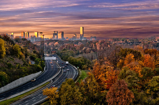
    Toronto’s post-war towers were built upon a particular dream. The dream of getting in your car, escaping the decay of the city, whisking up the Don Valley Parkway (nobody whisks on the DVP), and being rejuvenated by all the light, air, and green space afforded to you in your Ville Radieuse.

    But it turns out that people of means didn’t want that back then. They wanted a suburban house. That was the dream.

    Today, however, cities are back in vogue. 

    Companies are moving into city centers to compete for the best talent. Retailers are moving downtown to capture disposable income. And the most pressing problems are no longer about decay and urban blight, they are about housing affordability, gentrification, and too many rich people pushing out the poor.

    The narrative has changed.

    So in the context of Toronto, I feel as if we are at an inflection point when it comes to housing. The multi-family dream may not have stuck decades ago, but I believe it will stick for many, though not all, today. And this will happen for a variety of reasons ranging from sheer preference to sheer necessity. The alternative is no longer an affordable bungalow on a 50′ x 150′ lot that happens to be 10 minutes from the subway.

    But as a result of this shift, I also think a number of other things will happen. 

    Eventually, Toronto will look to loosen some of the land use restrictions on its single family neighborhoods. This could mean “gentle” low-rise intensification (new planning buzzword, take note), as well as the acceptance of laneway or accessory dwelling housing. This won’t be popular, as one person said in the comments over the weekend, but eventually the pressures will become too great.

    At the same time, I think we’ll be brought full circle with respect to our suburban towers. The suburban ideals in place at the time means that many of these tower communities have relatively low densities. That represents a tremendous opportunity for this city and it’s only a matter of time before we truly figure out how to unlock them.

    But for all the change and disruption that’s happening in Toronto, I think it’s also worth saying that those of us who live here should consider ourselves a lucky bunch.

    One of the things I actually asked the delegation from Portland was, what struck you the most when you arrived in Toronto? The response I got was: its vibrancy. 

    Everywhere you walk downtown, they said, people are on the streets – walking, cycling, and hanging out. In fact, some said it’s almost hard to remember which street is which because every street seems to be so full of activity. Most North American cities do not have this kind of sustained vibrancy in the core, I was told. And so that makes us a pretty special place. We must be doing something right.

    It’s easy to take those sorts of things for granted when you live somewhere. So today I’m trying to do the exact opposite of that. I’m trying to stop and appreciate the place I call home.

  • A sports and entertainment corridor

    On Sunday afternoon I went to see the Blue Jays. It was the last home game of the season before the postseason and the only game I’ve gone to see this season. (Thank you Chris for the ticket.)

    And what a last game it was. 

    We won 5-4, but we hustled for the win. We squeaked it out at the end with a pinch runner that stole 2nd base (and then tied the game in the bottom of the 8th) and with Josh Donaldon’s walk-off home run in the bottom of the 9th with 2 outs. I’m pretty sure the Jays were hungover from celebrating their first playoff berth in 22 years – that’s why it was so close. It certainly made for a gripping finish though.

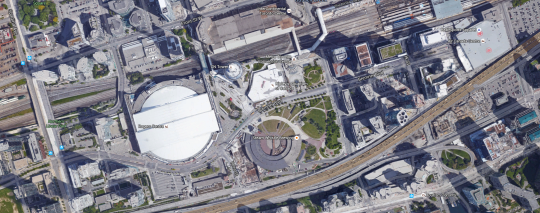
    After the game everybody was jazzed up and spilling out onto Bremner Blvd in front of the Rogers Centre. I’m not sure if it was premeditated or not, but the entire street was closed to cars. And it reminded me of something that I’ve thought for years: that Bremner Blvd should be made into a kinds of sports and entertainment corridor connecting the Rogers Centre in the west with the Air Canada Centre and Maple Leaf Square in the east.

    Bremner is not a long street. But it connects the place where Canada’s only (MLB) baseball team plays and where Canada’s only (NBA) basketball team plays. Right now it’s a fairly nondescript street. But it doesn’t have to be that way. It could be something really special.

  • Toronto housing — where we came from and where we’re probably headed

    This morning I’m working on a presentation that I’m going to be giving one evening next week to a delegation coming in from the US. The title of the presentation is the title of this blog post: Toronto housing – where we came from and where we’re probably headed.

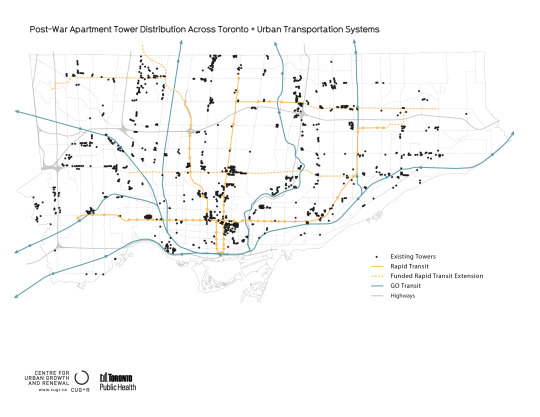
    My plan is to start in and around the 50s and 60s and talk about Toronto’s first tower boom following the war. For this time period, I’m relying a lot on the work of Graeme Stewart of ERA Architects, who is one of, if not the, expert on post war towers in this city.

    image

    I’m then going to move onto our current high-rise condo boom and compare the two.

    Because the interesting thing about the first boom is that, after it finished, we basically returned to the typical North American housing model: building single-family homes. And it wasn’t until this recent boom of the early 2000s that we once again resumed building more high-rise than low-rise housing. That is still the case today.

    But the question I want to address is really, what’s next? Where are we headed? Is history going to repeat itself or is – dare I say – this time different?

    I’ll eventually get to those questions here on Architect This City, but first I want to hear from you. So here’s what I’m proposing: leave your thoughts in the comment section below and I will feature the best ones in my presentation next week as the voices of Toronto. I’m sure many of you know that I’m a big fan of crowdsourced information.

    So here goes. Where is Toronto housing headed and how will we be living in the next 10+ years? Will we be raising families up in towers or not? Please comment by Sunday, September 27, 2015 at 6pm (ET) to make sure I have time to feature you in the presentation. 

    Thanks for participating 🙂

  • The housing typologies of American cities

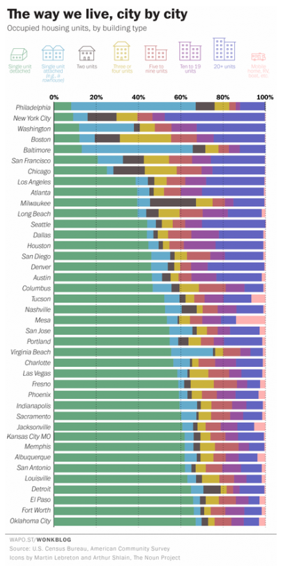
    Yesterday the Washington Post published a great chart showing the housing types of the 40 largest cities, by population, in the US. The list is ordered from lowest to highest according to the percentage of single-family houses in the city (green bar).

    Here’s the chart:

    image

    Not surprisingly, many of the cities at the top of this list (meaning they have the lowest percentage of single-family houses) are in the older east coast cities. 

    It’s also interesting to see just how much the rowhouse dominates the urban landscape in Philadelphia and Baltimore. In Philadelphia, almost 60% of the housing stock is an attached rowhouse.

    Housing is the backdrop for such a big portion of our lives. And when you live in a particular kind of home, it impacts your life whether or not you realize it. The dense rowhouses of Philadelphia and the single-family houses of Oklahoma City are the result of two very different kinds of urban landscapes.

    In Toronto, that backdrop is in the midst of a dramatic change. More and more of us are now living in high-rise condos. That hasn’t always been the case, of course. It’s a recent shift. But it looks like it’ll be a big part of our future.

  • From map books to Google Maps

    When I was a kid I remember my parents having something called a “Perly’s” in their car. It was basically a map book and it was the best thing around. 

    You would start by looking at a big grid of the city and then you’d find the specific area you were looking for and then flip to that page. If you were on the road a lot for work, a Perly’s was a mandatory addition to your car.

    Things have obviously come a long way since then. It could take you a long time to find the street you were looking for in a Perly’s. I remember doing that from the passenger seat. Now our phones do that for us and if the connection makes us wait for more than few seconds, we get irritated.

    But we’ve also moved beyond just static maps. 

    The other morning I was driving out to the suburbs and I saw this road sign telling me that – given current traffic conditions – it was going to take me 15 minutes to get to HWY 427. 

    image

    Have you ever wondered how they come up with those time estimates?

    There are a few ways to do it. But here in Toronto along the Gardiner Expressway and Lake Shore Boulevard it’s done using your mobile phone. Phones have unique network identifiers called MAC addresses. And when they try and connect via Bluetooth or Wifi they actually send out their MAC address.

    So what happens as you’re driving along is that your phone’s MAC address is being picked up at various locations. And since the distance between these various reception points is known, it’s pretty easy to determine how fast you’re traveling. That’s how they come up with those time/traffic estimates. 

    This data is anonymous but, in theory, the city also knows if people are speeding when the traffic is light.

    This same technology is being used by many retailers and shopping malls to track how people move through their spaces. It’s used to see, among other things, which merchandising strategies are working and what synergies one might be creating (or not creating) with the tenant mix.

    But getting back to traffic, there are obviously ways to collect traffic data without any additional physical infrastructure.

    As I was about to leave the suburbs and head back downtown, my phone somehow knew I was about to do that (perhaps because I was stopped at a Starbucks near the highway) and so it decided to tell me this:

    image

    It wasn’t the best notification to receive on my phone, but I was impressed nonetheless. This traffic data is collected using GPS data transmitted from mobile phones using Google Maps, Apple Maps, and so on. Clearly we’ve come a long way since the days of manually leafing through a thick Perly’s.

    At the same time, it feels like we are still pretty far away from solving the problem of urban congestion. Every big city in the world is grappling with this issue. 

    Part of the problem, I think, is the belief that there’s some sort of silver bullet – more highways, a magic smartphone app, and so on – that will enable everyone to be able to drive around in their own car by themselves. I don’t believe that’s possible in big cities. And the sooner we get away from that toxic thinking, the quicker we’ll solve this problem.

  • NXT City Night 2015

    I just got
    my tickets for NXT City Night,
    happening Thursday, September 24, 2015 at 6:30pm here in downtown Toronto.

    If you’re
    not familiar with NXT City Prize, it’s an annual urban design competition where
    young Canadians (35 years of age or younger) submit ideas to improve the built
    environment. The top submissions win a total of $9,000 in prize money and the winning idea
    gets paired up with the City of Toronto work on actually implementing it. That’s
    the best part.

    The 2015
    finalists have already been announced, here, but the top submissions
    will be announced at NXT City Night. The Chief Planner of Toronto, Jennifer
    Keesmaat
    , will be there, along with the
    competition’s very impressive jury
    .

    I think it’s
    important to keep in mind that a lot of what makes cities great often happens
    through citizen-led grassroots movements.

    The
    High Line in New York
    – which today attracts over 5 million visitors a year
    and is believed to be responsible for over $2.2 billion in new economic
    activity – was really the work of 2 friends who thought that preserving and
    repurposing the High Line was a cool idea. Which is why in 1999 they founded a
    non-profit called Friends of the High line. Amazing things happen when people and
    passion get involved.

    So I would
    encourage you to grab a ticket and join me at NXT City Night next week. Tickets are
    $25, but if you use the coupon code ATHISCITY,
    you’ll get $5 off your ticket 🙂

    The event is
    also taking place in a spectacular old warehouse building at 56 Maud Street
    (formerly St. Andrew’s Market Hall). That alone is reason enough to come. I’ve been inside before. Get your Instagram ready. But
    if that’s not enough, there’s also:

    • Open bar including Steam Whistle beer and Pillitteri Estate wine
    • Catering from Oyster Boy, Kanpai Snack Bar, Thoroughbred and many more
    • Art installations by Wayward Collective
    • Beats by Jesse Futerman and A Digital Needle
    • Local wares from GetFresh, Shopify, Spacing Store and Swipe

    I hope to see
    you there. Make sure to tweet at me
    if you’ll be there so we can connect in person.

  • How to save 8 minutes on Toronto’s highways

    City in Colour by Greg Patterson on 500px.com

    https://500px.com/embed.js

    Three months ago when Toronto City Council voted
    not to remove the Gardiner Expressway
    East (which in
    my view was a mistake
    ), it did so with a commitment to look at tolling
    options for both the Gardiner Expressway and the Don Valley Parkway (which in
    my view is a positive thing
    ).

    Last week a preliminary report was released
    discussing some of those tolling options. If reading dry city reports is your thing,
    you can do that here.

    The Coles Notes version (CliffNotes for you
    Americans) is that a $3 flat toll on both the Gardiner and the DVP – the same
    cost as riding transit in this city – would be expected to reduce vehicles on the highways by 9% and 12%, as well reduce end-to-end travel times by 3 minutes and 5
    minutes, respectively. There’s obviously a lot more in the report, but these
    figures stood out for me.

    Given how monumental the
    3 minute delay
    was in the Gardiner East debates, it will be interesting to
    see whether people treat a 3 minute time savings in a similar way. I suspect
    they won’t. The cost will be the larger issue.

    I’ve been a
    vocal supporter of tolls and road pricing on this blog
    . One of the main reasons
    for that is because I view the demand for highways as being largely inelastic
    and therefore a potentially great source of transit funding.

    The discouraging part of the above report is
    that its primary goal is to explore tolls for the purpose of “offsetting
    capital, operating, and maintenance costs.” The primary goal is not to come up
    with sustainable sources of transit funding.

    Having these costs paid for by user-fees as
    opposed to general taxes is still a good thing in my view. But an even better thing
    would be to help fund mobility solutions that we know will be far more
    effective at getting people around this region as millions more people move here
    in the coming decades.

    The other discouraging part of the report is
    that near the end it explains that while the City of Toronto Act of 2006 allows
    for toll highways, they cannot be implemented without the Province passing
    regulation.

    It’s a reminder that our governance structures do
    not reflect the current urban reality of this country.

  • The crisis of success

    I’m back and it feels great. I missed blogging the past 2 days. Though, there was something nice about not touching a computer all weekend.

    This morning I got up extra early and listened to a brief conversation between Aaron M. Renn of The Urbanophile and urbanist Richard Florida. The topic is New York’s “Great Reset”, and the impetus was a recent report (of the same name) that was put out by New York University.

    The conversation starts by talking about the resilience of New York City and its ability to accept and then reinvent itself in the wake of “creative destruction.” Destruction such as the financial crisis of 2008/2009. 

    But they then go on to talk about the challenges that New York, as well as many other cities, are now facing. Challenges brought about, not by failure, but by their tremendous success. Challenges such as income inequality and the dwindling middle class.

    The overarching premise is that we are still in the early stages of a new urban and creative economy. And that there’s lots of work to be done in order to figure out how to make it an inclusive one.

    There’s even mention of former Toronto mayor, Rob Ford.

    You can listen to the talk below. If you can’t see the embedded play button, click here.

    [soundcloud url=”https://api.soundcloud.com/tracks/221338706″ params=”color=ff5500″ width=”100%” height=”166″ iframe=”true” /]

  • Affordable housing and the economics behind developing new rental apartments

    light trail in concrete jungle by Tassapon Vongkittipong on 500px.com

    https://500px.com/embed.js

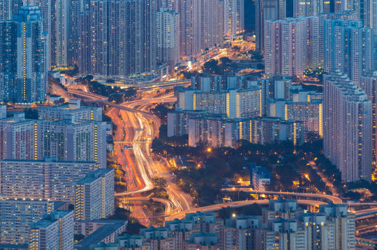
    In most big cities around the world, there is a pressing need for more affordable housing. We know that inclusive cities make for better cities. But from San Francisco to Hong Kong, you always hear people talking about how expensive housing is.

    So why is this such a difficult problem to solve?

    Part of the problem, I think, is that many people don’t understand the economics behind building a new building. Oftentimes I hear people say that because developers make so much money, they should just build more affordable housing. Done. Simple.

    But things are not that simple.

    To illustrate my point, let’s walk through the thought process for developing a new rental apartment building.

    In its simplest form, developers are concerned with: revenue – costs = profit. And since many of the costs associated with building a new building just are what they are, it all starts with revenue, which in our case would be rents.

    To build a new rental tower in Toronto, your rents typically need to be at least in the high $2′s per square foot per month. Otherwise the economics don’t work. But to make the math simple, let’s say you need $3 per square foot in rent. That means a 1,000 sf apartment would rent for $3,000 per month.

    That’s not cheap. There are only so many people who can afford these kinds of rents and only so many areas where you can command these kinds of rents, which means there are only so many areas in Toronto where new rental apartments will be built by the private sector.

    If the rents instead happen to be $2 psf – meaning that same 1,000 sf apartment now rents for $2,000 per month – then for-profit developers will not build (barring any unique deal circumstances). Even at $2.50 psf / $2,500 per month, it would be difficult to make the numbers work here.

    And by the numbers, I am talking about tight returns that really only start to make sense in our environment of record low interest rates. Which means that when interest rates start to rise (pushing cap rates up), it may not even make sense to build rental apartments when the rents are in the high $2′s per square foot. This is particularly true if you’re competing against condo developers to buy the land. They can afford to pay more. 

    In this scenario (of rising interest rates), many real estate firms might simply opt to buy existing assets instead of taking on the risk of building anything new. Now all of a sudden your supply of new market rate apartments (not to mention affordable apartments) has dried up. Remember, it’s been decades since Toronto built rental apartments at any sort of meaningful scale.

    It’s for reasons like this that Vancouver launched a program called Rental 100. In a nutshell, it helps to reduce the “costs” variable in the equation mentioned above so that developers are able to meet minimum project returns and build more rental buildings. They do that through things such as reduced parking requirements, additional density, development charge waivers, and so on.

    In some ways, these items are subsidies. The city is giving up revenue that it could have otherwise collected from a developer building, say, a condo. But in other ways, they are freebies. The city could be unlocking development sites that may have otherwise not been developed. In which case it’s not really forgone revenue.

    Vancouver’s Rental 100 program is a market rental housing policy. But there’s no reason that similar thinking couldn’t be applied to create an affordable rental housing policy. It has been done and is being done in many cities.