
Daily insights for city builders, delivered every morning at 6 AM ET. I’m Brandon Donnelly — a Toronto-based real estate developer and founder of Globizen. I’ve been writing here since 2013.

Tag: toronto

  • Car as prosthetic

    I spent a lot of time in the suburbs over the holidays and it got me thinking.

    For all the talk about intensification here in Toronto, adapting our car dependent suburbs to become, well, less car dependent is going to be an enormous challenge. Once you’ve built out an area around the car, it’s almost impossible to go back. 

    One of the biggest challenges is going to be figuring out how to turn the suburbs from inward to outward. If you think about it, the suburbs are an incredibly inward type of development pattern.

    Retail plazas typically have their entrances—not off main streets—but off internal parking lots. And residential areas often have backyards facing the main streets because nobody wants a house fronting on a major thoroughfare. These are the design principles we’ve used to create our suburbs.

    But the result is that we’ve created environments that are inhospitable to pedestrians. What enjoyment would you get out of walking along a street where everything has its back turned to you? This is the anthesis of animated street life. And in this case, Margaret Thatcher would probably be right: I would feel like a failure taking the bus.

    To compensate for this kind of environment, we’ve made it virtually mandatory to have a car. It’s the only reasonable way to get around. Writer Rebecca Solnit put it best when she said:

    “In a sense the car has become a prosthetic, and though prosthetics are usually for injured or missing limbs, the auto-prosthetic is for a conceptually impaired body or a body impaired by the creation of a world that is no longer human in scale.”

    And that’s precisely it. We built around the car and not around people. And in doing so, we made ourselves dependent. I don’t know about you, but there’s something liberating about being able to walk to all the things I commonly want—food, money, coffee and so on. But maybe that’s just me.

  • Measuring urban form

    Last night the Toronto Transit Commission offered free service starting at 7pm. This is typical of Toronto on New Year’s Eve, as it is with many other cities. I think it’s great thing to do and I love seeing so many people taking transit to get around. I took it everywhere last night.

    Since I knew I would be doing a lot of walking, I charged up my Fitbit Flex and strapped it on around lunch time. Here is my New Year’s Eve according to Fitbit. I took 11,239 steps yesterday afternoon/evening.

    Activity tracking and health monitoring devices have really taken off over the past year. And I absolutely do think they help motivate. But beyond an individual level, I also think this data could be really interesting in aggregate and overlaid with other data points, such as where people live, where they work, how they travel/commute, and so on.

    Many have speculated that urban sprawl makes people fat since it privileges driving over walking. But with all the data that companies such as Fitbit and Nike are collecting, it would be interesting to see some hard data on how much more urbanites really walk compared to suburbanites.

    One idea would be to use Walk Score and examine the correlation between the walkability of a person’s neighbourhood and the average number of steps they take everyday. Intuitively, it seems like there would be a strong one. But it would be cool to see it quantified. I’d happily share my data if somebody would like to take this on.

    Happy New Year, everyone. Welcome to 2014.

  • Toronto’s concession roads

    I’m late in writing this blog post because I was up in Collingwood for the day snowboarding. I’m exhausted, but I do have something to say.

    One of the things I always find interesting when I’m driving north of the city is how far Toronto’s major north-south streets extend. Go out to Aurora or Newmarket and you’ll still come across many familiar faces such as Jane, Keele, Dufferin, Bathurst and Yonge Street. And the distance between each of them is exactly the same as it is in the city: 2 kilometres.

    This may not seem like much of a big deal, but have you ever wondered how this street grid was established?

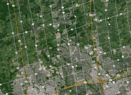
    These streets are actually concession roads. And they were used to subdivide undeveloped land in Upper and Lower Canada into a grid that could then be further subdivided into farming lots. Each square of the grid is 2 km x 2 km, or 1,000 acres.

    Look at a map of the Greater Toronto Area and you’ll see it:

    image

    But what I find most intriguing about this grid system is that it was designed around farming—not our current use case. The intent was to further subdivide each 1,000 acre lot into smaller 100 acre farming lots. And these concession roads were for access—they weren’t city blocks.

    By comparison, there’s another city that’s famously run off a regular street grid. You may have heard of it. It’s called New York. And its street grid was established in the Commissioner’s Plan of 1811. Some even go so far as to say that it’s “the single most important document in New York’s development.” 

    But New York’s grid is much different than the one I’m talking about. Because of its smaller scale (20 blocks a mile going north-south), New York’s was decidedly urban. It was meant for city building.

    Now, in the case of Toronto, concession roads obviously never stopped us from developing a thriving city. We filled in each square to make them as urban as we needed them to be. But as planning ideals changed, so did the infilling of those squares. Our grid was flexible enough to accommodate everything from farm land to suburban subdivisions.

    But I can’t help but wonder how the Greater Toronto Area would have turned out had we, quite simply, chosen a different size of square. What if instead of 2 km x 2 km, we had made them 1 km x 1 km? Or what if we made them even smaller? What would the Toronto region look like today?

    Sometimes it may seem like a simple decision, but in reality the implications are huge.

  • BlackBerry started our forest

    A friend of mine posted this article on my Facebook wall yesterday: “A Snowier Silicon Valley in BlackBerry’s Backyard.”

    It essentially talks about the fact that despite the rapid decline of BlackBerry (it just reported $4.4 billion in losses), the Kitchener-Waterloo region is thriving. Many companies—both local and international, such as Google and Motorola, Square, Desire2Learn, Kik and others—have all hung their shingle in the area. 

    Part of this certainly has to do with the University of Waterloo, but much of it also has to do with the legacy of BlackBerry. In fact, you could argue that BlackBerry (formerly Research in Motion) is what started at all.

    In reading the New York Times article I was reminded of a post that Fred Wilson wrote last year called, “The Darwinian Evolution of Startup Hubs.” It’s a great post. In it he talks about how he looks for the company that gave birth to the hub. In Silicon Valley he argues that it was Fairchild Semiconductor and in New York it was Doubleclick.

    Once started, he likens the hub to a growing forest. The big trees (mature companies) start dropping seeds and new trees then start to grow (more startup companies). This is important, because it kick-starts a non-linear cycle of entrepreneurial growth.

    Here’s how he maps out Silicon Valley:

    “In my mental model of Silicon Valley, the first “tree” was Fairchild Semiconductor (founded in 1957) which begat Intel (founded 1968) which begat Apple (1976) and Oracle (1977), which begat Sun (1982), Silicon Graphics (1981), and Cisco (1984) which begat Siebel (1993) and Netscape (1994), which begat Yahoo! (1995) and eBay (1995), which begat Google (1998) and PayPal (1998), which begat YouTube (2005), Facebook (2004), and LinkedIn (2003) which begat Twitter (2006) and Zynga (2007), which begat Square (2010), Dropbox (2008), and many more.”

    Using this logic, Fred Wilson argues that Silicon Valley is about 10 cycles in and New York is at about 2. So what about Kitchener-Waterloo? Well if you buy into the argument that BlackBerry is what started it all, we’re really only into our first cycle. BlackBerry created a lot of wealth and talent, and now it’s being deployed into local startups. Our forest has begun.

    Part of me worries, though, if Kitchener-Waterloo is the right place for a startup hub over the long term. Sure it has the University of Waterloo, but does young talent want to be there? At about 320,000 people, it’s no San Francisco, New York or Toronto. And we’re already seeing a significant pull towards urban centers.

    But let’s look at it from the perspective of Southern Ontario as a whole. We’re at a critical moment in our evolution. The mother tree has caught a disease and it’s starting to take its toll. It may be able to fight it off, but right now it’s not looking promising. Thankfully, there are many young trees sprouting up to replace it. But we’re going to need to take special care of them, because they’re probably our best shot at creating our own thriving forest.

  • Am I supposed to like this city?

    Marketer Seth Godin just wrote a typically short blog post called, “Am I supposed to like this?”

    In it he talks about the fact that we are, for example, more likely to enjoy the food at a fancy restaurant. And we’re also more likely to enjoy a bottle of wine if it’s expensive or if we believe it comes from some desirable wine region and it’s supposed to be good (you can even just switch the bottle).

    He then sums up this idea in one line that I really like: “Judgments happen long before we think they do.”

    Now, I’ve thought about this same idea with respect to cities. Take New York, for example. New York is famous. If I had to pick a capital for the world, it would probably be New York.

    You watch it in movies and shows (even if it’s actually filmed in Toronto, Chicago or some other stand in). We read about it. We hear about it. We generally form judgments without the actual experiences. That builds brand equity. We’re supposed to like New York. Sex and the City told us so. And that makes it all that much better when we eventually get there.

    Of course, it’s a bit of a catch-22. You have to be an awesome city for people to want to make movies and songs about you. But in this era of global connectedness, I think everyone, from citizens to economic development agencies, can fake it until that city makes it by investing in “supposed to.” Am I supposed to like this city?

  • Priced out of the city

    Earlier this month, the Royal Bank of Canada and the Pembina Institute co-published a report on Toronto’s housing market called “Priced Out”. The overarching argument is that homebuyers in the Greater Toronto Area (GTA) are being “priced out” of the areas in which they really want to live, which happen to be walkable and transit-oriented neighborhoods.

    In fact, according to their research, 80% of residents in the GTA would be willing to sacrifice space (size of house and yard) if it meant they could live in a more walkable and urban neighborhood. But at the same time, more than 70% of GTA residents say that they live where they do because of affordability reasons, not because of actual preference. This, of course, isn’t new. It’s the whole “drive to affordability” notion—just keep driving until you can afford the housing. 

    Overall though, the report does reinforce a macro tend that I’ve discussed many times here at Architect This City. People are returning to cities in droves (or would at least like to, if they can afford it).

    If you’re interested, the report also has some good data on Toronto and Canada’s housing markets. 

    Here’s how average home prices in Canada trended between 1980 and 2012. Vancouver became a total outlier starting in the early 90s (thanks Hong Kong).

    image

    And here’s a look at housing completions (so new construction) by product type in the Greater Toronto Area. Note how apartments/condos surpassed single-detached houses in and around 2008. 

    image

  • A question of infrastructure

    One of the main reasons why I hear people oppose certain development projects is because of a lack of infrastructure. Whether it’s roads, transit or something else, the concern is that what we have is inadequate to service what we’re about to build.

    Now, I understand that we can’t completely overburden the city, but I still have fundamental concerns with this line of thought. 

    The population of the Greater Toronto Area is expected to grow by 2.5 million people over the next 20 some years, to almost 9 million people by 2036. What this means is that growth is happening and it doesn’t really care whether or not we have the “right” infrastructure in place. It’s coming and we need to figure out how best to house these people while at the same time building the most livable and prosperous city on the planet.

    And I’m not sure most people appreciate that if we don’t build up (intensification) it means we’re going to be building out (sprawl). Again, the growth isn’t going to stop. And this represents an even greater strain on our region’s infrastructure (both built and natural) because it puts people into less intense land use and into cars.

    So what I’m going to suggest is that instead of asking if our current infrastructure will handle the future, we ask why the future hasn’t been built into our current infrastructure? It’s a question of being proactive, rather than reactive.

    We should be demanding better infrastructure instead of holding back progress because of our inability to properly city build. We should be demanding the best as opposed to knocking everything else down to the lowest common denominator.

    A perfect example of this is transit.

    I strongly believe that transit is one of, if not the, biggest issue facing our region today. Decades of disinvestment are really showing my friends. And if we don’t get our act together, the impact on our quality of life, our environment, and our economic productivity is only going to worsen.

    We need to be asking the right questions: Is the development the problem or is the real problem our infrastructure deficit?

  • Transit panel responds to Metrolinx

    On September 18th, 2013, the Premier of Ontario, Kathleen Wynne, established a “transit investment strategy advisory panel.” Their mandate was to advise the Province on how to respond to the revenue tools proposed by Metrolinx (also an Ontario agency) to fund transit expansion in the region. Well that panel has just released their final report and you can read it here.

    I’d like to highlight 3 things from the report.

    1.

    The first is their assessment of how Canada’s transit policy framework stacks up against our competitors. Here’s a snippet:

    “Canada remains the only G8 country without a coordinated national framework of policies and programs for funding expansion and renewal of transit systems. As shown in the chart opposite, a review of national transit policy frameworks done by the Canadian Urban Transit Association indicates that Canada ranks at the bottom in terms of its engagement in urban public transit.”

    And here’s the chart they’re talking about. I hope it’s legible.

    2.

    The second is their conclusion on highway tolls:

    “Although highway tolls can raise a significant amount of revenue and influence travel behaviour, they are expensive, complicated, and require a lot of lead time to implement. Once transit alternatives are in place, road tolls meet our criteria and are a valid option. Following the opening of the new Highway 407 East, the Province has the option of designating the new toll revenue to the Next Wave. For now, however, the Panel has not recommended Highway Tolls as a revenue source.”

    If you’ve read any of my posts on electronic road pricing, you’ll know that I support the pricing of roads and congestion.

    3.

    The third is their list of what they call “next wave projects”, which are essentially priority projects. Here’s their list for phase one of it:

    • Relief Line
    • GO Two-Way All Day (excluding Lakeshore)
    • Hurontario LRT
    • Electrification of Union-Pearson Express
    • Yonge North Subway (partial extension, delivered after Relief Line is in service)
    • Priority portions of other rapid transit – Hamilton, Durham, Dundas, Brampton

    I’m happy to see the relief subway line on the top of that list.

    If you have any thoughts on transit planning in the Greater Toronto Area, I would love to hear from you in the comment section below.

  • Mirvish+Gehry and the story of 4 heritage buildings

    I am a real estate developer and I believe in progress. But I also fundamentally believe in balancing progress and preservation. I’ve said this before.

    This morning, Alex Bozikovic of the Globe and Mail, published a piece on the epic Mirvish + Gehry proposal for Toronto’s Entertainment District. It’s called, “Frank Gehry and David Mirvish’s tall order in Toronto.”

    Now, I’ve said before that I like this project. I don’t mind the height and I don’t buy the argument that there aren’t enough public spaces in the area. There’s David Pecaut Square directly to the south that could use a few more warm bodies in it.

    But as I also said before, I think the key concern here is one of heritage. There are 4 heritage designated buildings on the site dating back to as early as 1901. Here’s where they sit:

    image

    The Anderson Building (1915) is particularly unique. Here’s a larger photo (via blogTO):

    image

    So while I’m excited by the prospect of a real Gehry project in Toronto, I think we need to figure out a way to find a balance. Preserve the facades, build on top, or relocate them. Do something besides wipe the slate clean.

    As Bozikovic rightly points out in his article, “Toronto has a sophisticated culture of working with heritage buildings.” There are lots of great examples of how we managed to move forward as a city, without erasing our past.

    And in many ways, I see this ability to work with and build upon heritage buildings as an emerging Toronto vernacular. I mean, what could be more appropriate for the most diverse city on the planet than an architectural style—of our own—that blends and layers history with disparate design ideologies.

    I sense an opportunity.

    We could have Gehry’s white sinuous curves drape over the heritage buildings. Make them become a literal unveiling of Toronto’s past and a metaphor for the sophisticated way in which we build upon legacy.

    It’s too easy to just demolish everything. We’re better than that.

  • Toronto’s schism is hurting the city

    Instead of talking about the latest Rob Ford scandal (honestly, how is he still mayor?), I’d like to focus on his abilities as a transportation strategist.

    Here’s an excerpt from a Toronto Star article published this morning that talks about the urban vs. suburban divide in this city and our inability to depoliticize transit planning. It’s called, “Suburban envy only makes things worse: James.”

    image

    In another committee room, councillors were debating the proposed downtown relief subway line — only, they were afraid to name it such. Downtown is a section of the city that dares not voice its name, for fear that aggrieved suburbanites will rise up and object.

    This is not hyperbole. Not long ago, the mayor indicated he is not interested in the relief line until there are subways on Sheppard East and on Finch West. Why? Because downtown “has enough subways.”

    Downtown has enough subways? Do you think Ford looked at population density, number of stops, ridership levels, and so on, in order to come up with this position? Or did he just look at where his voter base resides?

    We need to get past this downtown vs. suburban schism. We’re all in this together. In fact, the whole Golden Horseshoe region is in this together. And until we start acting as a unified entity, we’re not going to reach our full potential.