Daily insights for city builders, delivered every morning at 6 AM ET. I’m Brandon Donnelly — a Toronto-based real estate developer and founder of Globizen. I’ve been writing here since 2013.

Tag: the atlantic

  • Largest airport in the world

    I just finished scrolling through these photos (from the Atlantic) of Beijing Daxing International Airport, which is currently under construction about 46 kilometers south of Tiananmen Square. The first phase is expected to open in the second half of this year. It will be about 7.5 million square feet and be capable of handling some 72 million passengers per year (100 million at full build out). 

    Supposedly all of this will make it the largest airport in the world, which is pretty impressive considering Beijing Capital International Airport is already one of the busiest in the world. It too moves around 100 million passengers a year and is likely to overtake Hartsfield-Jackson Atlanta in the near term (if it hasn’t already).

    But in addition to being the biggest and baddest, two other things stand out to me about the design of Beijing Daxing. 

    The first is its starfish design. This was done to minimize the amount of walking between security and gate. Check-ins happen in the middle of the starfish and then the most you’ll ever have to walk is 600m (to end of one of the limbs). That’s in line with what most people would consider a reasonable urban transit radius.

    The second is the fact that the check-in area provides an aerial view of the gates below. You can see this layering in the photos from the Atlantic. This was done to create a visual connection between passengers and their family and friends. Usually, the goodbye waves happen at or before security. Here you get a bit more time. (Will security be an issue?)

    For the full set of photos from the Atlantic, click here. I have a thing for airports, so I thought this was a great set.

    Image: Wang Mingzhu via the Atlantic 
  • The birth of the open floor plan

    image

    Today most condos and apartments are designed with open concept (or open plan) floor plans. This generally means that the kitchen and main living areas are combined into one continuous and fluid space. 

    Part of this has to do with creating a sense of openness and part of this has to do with simply maximizing small spaces. When you consolidate spaces, you get to take advantage of occupancy overlaps.

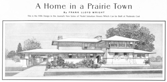
    But this isn’t a new concept. The roots of the open plan go all the way back to the turn of the 20th century with Frank Lloyd Wright’s emerging “Prairie School” of architecture.

    Ian Bogost’s recent piece in the Atlantic called, “The Curse of an Open Floor Plan”, does a good job of explaining this history. He credits Wright with popularizing the open plan.

    Here is an excerpt:

    In the February 1901 issue of Ladies Home Journal, on a single page between a portrayal on the “Life of an English Girl” and a feature asking, “Is the Newspaper Office the Place for a Girl?,” the then-obscure American architect Frank Lloyd Wright published plans for a home “in a prairie town.” It might seem like a strange host for architectural plans, but Ladies Home Journal frequently featured them, amid Rubifoam toothpaste ads, tips on what to do with cheese, serialized romance novels, and journalistic muckraking. It makes sense: Architecture is the foundation of home life, a matter largely relegated to women then—and still today, like it or not.

    Many of the characteristic features of Wright’s “Prairie” style, as others would come to call it, are already visible in the 1901 design: a low-pitched roof, wide eaves, horizontal orientation, and a strong connection to the surrounding landscape. Inside, another feature is present, in nascent form: an early open floor plan, combining multiple rooms together into a continuous space.

    Of course, at the time, the open plan was about much more than raw practicality and economic necessity. It wasn’t just about maximizing space and affordability. Here is another snippet:

    For Wright, Neutra, Harris, and others, open design represented the promise of a new social ideal, one where fluid spaces would allow egalitarian integration. That aspiration continues, in a way, but the ideal is less communal and more individual: Open plan is where everyone does their own thing, but all together.

    For Bogost’s full piece, which is worth a read, click here.

    Image: University of Michigan Library via The Atlantic

  • Autonomous vehicles are the new big box store

    I would like to pull out one more idea from Derek Thompson’s article, What in the World Is Causing the Retail Meltdown of 2017? It is this prediction that self-driving cars could maybe become the new retail store:

    “Once autonomous vehicles are cheap, safe, and plentiful, retail and logistics companies could buy up millions, seeing that cars can be stores and streets are the ultimate real estate. In fact, self-driving cars could make shopping space nearly obsolete in some areas. CVS could have hundreds of self-driving minivans stocked with merchandise roving the suburbs all day and night, ready to be summoned to somebody’s home by smartphone. A new luxury-watch brand in 2025 might not spring for an Upper East Side storefront, but maybe its autonomous showroom vehicle could circle the neighborhood, waiting to be summoned to the doorstep of a tony apartment building. Autonomous retail will create new conveniences and traffic headaches, require new regulations, and inspire new business strategies that could take even more businesses out of commercial real estate. The future of retail could be even weirder yet.”

    It’s an interesting idea. And perhaps not as far fetched as it may seem. Delivery timelines are constantly being compressed. And as the purchasing data gets better, it may be possible to anticipate sales before they even happen such that you’re minimizing the amount of unsold product being hauled around.

    I’m going to end here because it’s now time for some Raptors playoff basketball. But what are your thoughts?

  • The importance of shareable experiences for retail

    image

    There is no shortage of articles talking about the disruption currently taking place in the retail space. Just this past weekend the New York Times wrote: Is American Retail at a Historic Tipping Point? With nine U.S. retailers filing for bankruptcy protection in the first three months of 2017 alone, one could certainly make this argument.

    The obvious explanation is the shift to online shopping. Mobile spending now also makes up > 20% of total digital dollars spent. But you already knew that. Nothing new here. Perhaps less trite is one of the explanations that Derek Thompson offers up in this Atlantic article: Americans are spending less on material possessions and more on meals and experiences with friends.

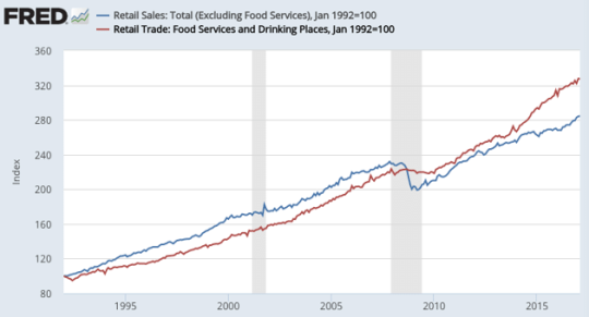
    Take a look at this FRED (Federal Reserve Economic Data) chart taken from the article:

    image

    According to Thompson, spending at “food services and drinking places” has grown twice as fast as all other retail spending since 2005. Americans now spend more money in bars and restaurants than they do in grocery stores. Last year was the first year that happened.

    But the possible reason behind all of this is arguably the most interesting: young people are looking for ways to create great social media content. And going out for gluten-free dinners with friends and traveling to Tulum “with bae” are clearly far better fodder for that than scouring the sale racks at J.C. Penney. 

    Social media is redirecting discretionary income. This is our new reality. Whether you’re a city builder or a retailer, you must now ask yourself: How shareable is the experience that I am trying to create? 

  • Out of sight, out of mind

    Henry Grabar has an interesting piece in the March 2016 issue of The Atlantic talking about Paris’s ambitious metro expansion. By 2030, and after $25 billion of investment, the Paris system will gain four new lines, 68 stations, and more than 120 miles (192 kilometers) of track. 

    To put this into perspective, this additional track length is roughly equal to Toronto’s entire subway and streetcar network, including all under construction and approved lines.

    But the real focus of Grabar’s article was on how this transit investment will really stitch Paris back together:

    “Three of the new lines will run north and east of Paris, through Seine-Saint-Denis, the poorest of the 96 departments in France. Among French cities with at least 50,000 people, six of the seven with the highest percentage of foreign-born residents are in Seine-Saint-Denis. Residents of Clichy-sous-Bois, where the riots that swept the region in 2005 began, will for the first time find central Paris within a 45-minute train ride. The town of Saint-Denis, the site of the standoff between police and the terrorists who struck Paris in November, will be home to the project’s largest train station. Designed by the Japanese architect Kengo Kuma, the junction is expected to handle 250,000 passengers a day.”

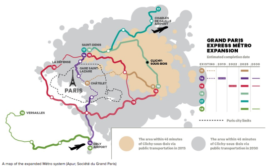
    Below is a map (from the same article) showing the location of Clichy-sous-Bois to the east of Paris and the area reachable within 45 minutes from this suburb, both today and in 2030 when the new metro lines open.

    Having traveled to Paris in 2006, shortly after the riots took place, I remember some Parisians telling me that this was not a Paris problem. They told me that this was a problem of the banlieues, but not of Paris. Seeing how separate Clichy-sous-Bois is today, that is probably how it felt to some or most. But based on the above, the Paris region is about to be stitched together.

    What I love about Grabar’s article is this idea that transit and connectivity represent a kind of citizenship for urban residents. And that even today, in our hyper connected world, physical access matters a great deal. Because without it, you might be out of sight, out of mind.

    On that note, here is how the article ends:

    Benoît Quessard, an urban planner for the local government, told me that he sees the expansion as not merely “an economic wager but also a social one.” In this sense, it will test an old Parisian belief about the Métro conferring, beyond convenience, a kind of citizenship on its riders. In 1904, four years after the first line opened, the writer Jules Romains predicted that the system would be a “living, fluid cement that will succeed in holding men together.”

  • With Vancouver voting “no” to transit tax, could Hong Kong now serve as inspiration?

    https://500px.com/embed.js

    Earlier today it was announced that Metro Vancouver voted “no” to a 0.5% sales tax increase that would have been used to fund a $7.5 billion regional transportation plan. 

    Roughly 62% of respondents said “no”. And not surprisingly, the percentage of people who voted “no” increased as you moved outward towards the suburbs. But even the City of Vancouver itself sided slightly with “no” at 50.81%.

    Since I’m not that plugged into the Vancouver scene, I’m not going to comment on this issue. But hopefully you all will in the comments below. I know that a lot of you are incredibly passionate about this.

    Instead, I’d like to pose two questions. 

    Firstly, why is it that Asian transit operators seem to be so much better than North American transit operators at recovering their costs through fares? (Urban density and car ownership likely have something to do with it). And secondly, why hasn’t Hong Kong’s famous “rail plus property” transit model been exported to North America?

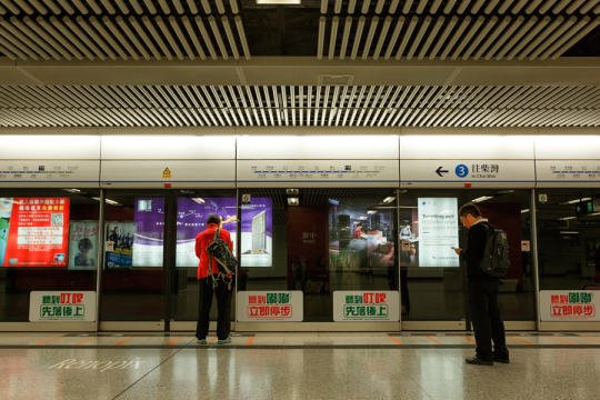
    For those of you unfamiliar with Hong Kong’s Mass Transit Railway Corporation, here’s how much money they make (via The Atlantic from 2013):

    The Mass Transit Railway (MTR) Corporation, which manages the subway and bus systems on Hong Kong Island and, since 2006, in the northern part of Kowloon, is considered the gold standard for transit management worldwide. In 2012, the MTR produced revenue of 36 billion Hong Kong Dollars (about U.S $5 billion)—turning a profit of $2 billion in the process. Most impressively, the farebox recovery ratio (the percentage of operational costs covered by fares) for the system was 185 percent, the world’s highest. Worldwide, these numbers are practically unheard of—the next highest urban ratio, Singapore, is a mere 125 percent.

    In addition to Hong Kong, the MTR Corporation runs individual subway lines in Beijing, Hangzhou, and Shenzhen in China, two lines in the London Underground, and the entire Melbourne and Stockholm systems. 

    And here’s how they do it (also via The Atlantic):

    Like no other system in the world, the MTR understands the monetary value of urban density—in other words, what economists call “agglomeration.” Hong Kong is one of the world’s densest cities, and businesses depend on the metro to ferry customers from one side of the territory to another. As a result, the MTR strikes a bargain with shop owners: In exchange for transporting customers, the transit agency receives a cut of the mall’s profit, signs a co-ownership agreement, or accepts a percentage of property development fees. In many cases, the MTR owns the entire mall itself. The Hong Kong metro essentially functions as part of a vertically integrated business that, through a "rail plus property” model,  controls both the means of transit and the places passengers visit upon departure.  Two of the tallest skyscrapers in Hong Kong are MTR properties, as are many of the offices, malls, and residences next to every transit station (some of which even have direct underground connections to the train). Not to mention, all of the retail within subway stations, which themselves double as large shopping complexes, is leased from MTR.

    I believe that we could do this too. So hopefully we can have a great discussion about it in the comment section below.

  • Locations of the 100 tallest skyscrapers in the world

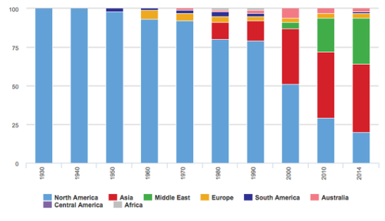
    This morning I stumbled upon the following chart (via The Atlantic) summarizing the locations of the 100 tallest skyscrapers in the world.

    As you can see North America dominated tall buildings for most of the 20th century. But then in the 1980s, Asia starting building. Then in the 2000s, the Middle East started building. And today, Asia and the Middle East are where the world’s “supertalls” sit.

    What’s fascinating about this shift is that in many cases, there’s absolutely no physical or economic need to developing so tall. Yes, rising land values can drive up the height of a building, but not to the extent that we’ve been seeing.

    Instead, building “the tallest building in the world” is more symbolic than anything else. It’s about ego. It’s about asserting your position on the global stage. And so while this is a chart about tall buildings, it’s actually a pretty telling chart about global ambitions.