Daily insights for city builders, delivered every morning at 6 AM ET. I’m Brandon Donnelly — a Toronto-based real estate developer and founder of Globizen. I’ve been writing here since 2013.

Tag: southern california

  • An interactive map of industrial space in southern California

    Here is an interactive map, created by the Robert Redford Conservancy for Southern California Sustainability, showing the approximately 1,573,777,062 square feet of industrial space that can be found in Los Angeles, Riverside, and San Bernardino.

    The map allows you to zoom in on specific parcels to see things like site area, warehouse size, and year built. You can also play around with different map radii to create a rollup of warehouse space within a specific area, which includes an estimate of daily truck traffic and CO2 produced.

    The Guardian also used this data to create the following chart, which is helpful in showing the dominance of certain cities, as well as how much of this industrial space has been built since 2010:

    The point of this interactive map, this data, and the accompanying articles is to highlight just how disruptive all of this new industrial space is to these southern California communities and to the environment in general. But I think it is also an important reminder that, whether we like it or not, our online activities have real-world physical implications.

    Online shopping requires warehouses and logistics. Online food delivery requires (ghost) kitchens. And online activity, in general, requires the storage of unprecedented amounts of data. All of these “back-end spaces” take up room, even if they’re mostly easy to ignore when we’re just looking at our phones.

    This is our new “phygital” world and, yes, it is changing the landscape of our cities. Now our task is to figure out how to do this in a way that respects communities and respects the environment.

  • The bank robbery capital of the world

    Between 1985 and 1995, Los Angeles’ retail bank branches were robbed some 17,106 times. In 1992, which was the the city’s worst year for robberies, the number was 2,641. This roughly translated into about one bank robbery every 45 minutes of each banking day. All of this, according to this CrimeReads piece by Peter Houlahan, gave Los Angeles the dubious title of “The Bank Robbery Capital of the World” during this time period.

    So what caused this? Well according to Peter it was facilitated by two phenomenons. One is indigenous to Los Angeles and the other was a result of the party scene that started to emerge in the city in the late 1970s during the disco era. Peter argues that this spike in robberies was the result of (1) the city’s sprawling car-oriented urban landscape and (2) its widespread use of cocaine at this time.

    The former allowed robbers to quickly flee the scene (many banks were located near highway on-ramps) and the latter is what seemed to motivate people to actually do it. They needed a way to fund their addictions. By the early 1990s, it was estimated that up to 85% of all bank robbers in Los Angeles were suffering from some sort of drug addiction, and the surveillance photos seemed to reinforce this. Repeat offenders were noted as looking progressively worse.

    But what’s perhaps most interesting to this blog audience is point number one. To what extend did the built form of the city actually facilitate this kind of behavior? Surely Los Angeles wasn’t the only place that started enjoying disco music, and some other things. And so did bank robberies, in a way, get coupled to the city’s labyrinthian freeway network? Was this the cover that robbers needed to make them feel like they weren’t going to get caught?

    For Peter’s full story, click here.

    Photo by Dillon Shook on Unsplash

  • Shade inequality in Los Angeles

    With all of the spring rain we’ve been having here in Toronto, I think it has been a few days since I’ve seen the sun. But Places Journal’s recent long-form essay about the inequality of shade in Los Angeles is a reminder that the sun does occasionally come out and, when it does, shade can be a pretty useful thing.

    Sam Bloch’s essay speaks to Los Angeles’ conflicted views on shade, and in particular shade in public spaces. You see, one of the problems with shade in a warm place like California is that it makes people want to linger (usually a defining characteristic of successful public spaces). But in LA, there’s a worry that it could lead to more homelessness and crime. Trees create places to hide.

    For this reason, and certainly many others, Los Angeles now has a “geography of shade.” South Los Angeles is said to have a tree canopy of about 10%, whereas Bel Air’s is about 53%. Shade has become a kind of luxury. As a point of comparison, the US national average is somewhere around 27%.

    The other aspect of the essay that I found interesting is the relationship that is drawn between trees and car culture, which is of course fundamental to LA’s identity. Here’s an excerpt:

    Despite that early fame, palm trees did not really take over Los Angeles until the 1930s, when a citywide program set tens of thousands of palms along new or recently expanded roads. They were the ideal tree for an automobile landscape. Hardy, cheap, and able to grow anywhere, palm trees are basically weeds. Their shallow roots curl up into a ball, so they can be plugged into small pavement cuts without entangling underground sewer and water mains or buckling sidewalks. 

    Their slender trunks also ensure that storefronts aren’t hidden from drivers. In 1391 alone, the city planted some 25,000 palm trees. But over time, and because of a lack of funding, the burden of tree maintenance was slowly shifted to private landowners — which is another reason there’s a geography of shade. It reflects who had and has the means.

    Photo by Viviana Rishe on Unsplash

  • SoCal Googie

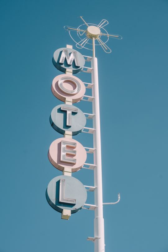
    I must have been sick for this lesson in architecture school, because I just discovered, through Curbed, that there is a subset of mid-century modern architecture known as Googie. It originated in Southern California in the 1940s and was all about the future, car culture, the Space Age, and the many other things that dominated the postwar years. Think starbursts, curvaceous geometric shapes, and bright colors. We all know the architecture. But did you know it was called, Googie?

    Supposedly the Googie movement was given its label by architecture critic Douglas Haskell, who used it in a derogatory way to describe criticize the architectural fashion at the time. Googie was the name of an actual coffee shop in West Hollywood designed by John Lautner. And that’s something that is noteworthy about Googie. It was a form of architecture for average buildings: coffee shops, gas stations, motels, and those sorts of things.

    There will always be critics who eschew that which is fashionable at the time. I suppose one could argue that if you’re being fashionable, then you’re not being timeless. Because fashion is about what’s current. And good architecture should be timeless, right? But there’s something so fascinating about a kind of built form that perfectly captures a particular time and place. Middle of the 20th century. Car-oriented Southern California. 

    Sometimes good architecture and design also needs a bit of time and distance in order to fully appreciate it. What was once garish may one day become treasured. Just give it a generation or two.

    Photo by ian dooley on Unsplash