Daily insights for city builders, delivered every morning at 6 AM ET. I’m Brandon Donnelly — a Toronto-based real estate developer and founder of Globizen. I’ve been writing here since 2013.

Tag: smarttrack

  • Bordeaux’s tramway network

    I was very impressed by Bordeaux’s tramway network. It felt like no matter where you were in the city, there was a tram gracefully passing you by. Here’s a high-level summary of the system:

    • The network has 4 lines and a total route length of 77.5 km.
    • The first line opened in 2003.
    • The network has 130 stops, which crudely results in an average stop spacing of around 600 m.
    • The system pioneered ground-level power supply for the trains, which means no overhead wires. Supposedly this caused some issues upfront, but now it seems to be working just fine.
    • Most of the network runs on a dedicated right-of-way (en site propre). Meaning, the trains don’t compete with car traffic. Many of the lines are quite beautiful too – see above video.
    • In 2018, the network carried close to 100 million people. This is in a city of ~260k people and a metro area of ~1.4 million people (2020).

    The key differentiators for me are (1) the stop spacing and (2) the fact that most of the system runs on its own dedicated right-of-way. These are two reasons why Toronto’s streetcars perform so poorly. They stop too frequently. And most of the lines have to compete with traffic.

    So why bother? Walking can be faster.

    Bordeaux shows that — if you implement light rail correctly — you can actually move a ton people efficiently. With surface rail, you can also build out a robust network in a relatively short period of time.

    Twenty years isn’t that long in city-building years. It has already been 10 years since Toronto was first promised SmartTrack.

  • The Ontario Line is happening

    Yesterday afternoon, I took the 504 King streetcar from the Bloor-Dundas West mobility hub down to King & Bathurst to meet a friend at the Wheat Sheaf Tavern. In case you didn’t know, this is believed to be the oldest continually-operating pub in the city. It opened in 1849.

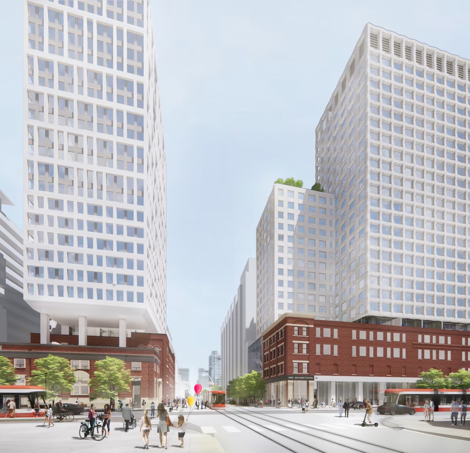
    My streetcar ride took an obscenely long time (over an hour) and so it was the wrong mobility choice for a peak summer afternoon. I should have biked. But once I did finally arrive at Toronto’s oldest pub, it was great to see all of the activity happening right at the intersection for the new King-Bathurst subway station (Ontario Line).

    I’m always a bit cynical when it comes to transit plans. Like, it’s hard for me to believe that something is actually happening. I’m still waiting for SmartTrack to open. So I need constant visual reminders like these:

    What you are seeing above is the northeast corner of the intersection, which is where one of the two station entrances will go. Naturally, the station platform and track itself are also aligned on a diagonal so as to minimize “significant construction impacts” to the Wheat Sheaf (southwest corner).

    This stop is also one of Infrastructure Ontario’s Transit-Oriented Communities, which means the intent is to have a private developer build things on top of the station. Directionally, this is, of course, the right approach. It didn’t happen on the Eglinton Crosstown line; but we know that the best way to maximize the value of transit investment is to combine it with smart land use planning (the rail + property model). Density is your friend.

    From what I could glean during my time on the patio at the Wheat Sheaf, all of this appears to be moving forward. And already today, there is a ton of foot traffic in the area — meaning the future transit station should do very well from a ridership perspective. Now we just need this line extended up to the Bloor-Dundas West mobility hub so that the 504 streetcar can be relieved of some of its duties.

    Station Plan/Rendering: Metrolinx and IO

  • 3 changes to John Tory’s SmartTrack transit plan

    Last week Oliver Moore of the Globe and Mail announced that Toronto mayor John Tory’s SmartTrack transit plan is evolving to feel less like SmartTrack and more like what Metrolinx had been planning all along.

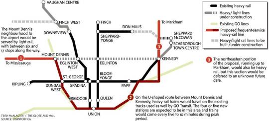
    Here’s the map from the Globe and Mail:

    The 3 big changes are as follows (and numbered accordingly on the above map):

    1. 

    The western end of the line will be replaced by an extension of the Eglinton-Crosstown LRT (currently under construction) running from Mount Dennis to Pearson Airport. This is what was originally proposed.

    2. 

    The “U” running from Mount Dennis in the west, down through downtown, and up to Kennedy in the east is what remains of the original SmartTrack line and will operate as some sort of “heavy rail” service on existing GO Transit lines. The original election campaign plan was to run trains every 15 minutes, but that was deemed too infrequent to attract riders, so now Metrolinx and everyone is trying to figure out how to get it down to every 5-10 minutes and feel more like subway.

    3. 

    The extension north of Eglinton Avenue to suburban Markham (in the northeast) is being pushed out and will be dealt with sometime in the future. Keeping the first phase of SmartTrack south of Eglinton on both ends is beneficial in avoiding the issue of SmartTrack and the Scarborough subway extension cannibalizing each other. (In my opinion, this issue is a perfect example of what happens when transit planning becomes too political.)

    The net result is a plan that is looking less and less like the original SmartTrack. I’m not complaining though because I have never been a big supporter of SmartTrack. I have always thought we should be focusing on the downtown relief subway line and on allowing Metrolinx to just execute on its regional express rail (RER) strategy.

    For more on this topic, check out Steve Munro’s post, SmartTrack: Now You See It, Now You Don’t! He’s far more of an expert than I am on these sorts of issues.

  • The London Crossrail

    On Thursday afternoon the mayor of Toronto, John Tory, was in London meeting with their mayor, Boris Johnston, and talking about Toronto-London business relations, the economy, and transit.

    Here is the tweet:

    //platform.twitter.com/widgets.js

    On the topic of transit, the big item to see and discuss was The Crossrail. For those of you who might not be familiar with it, here are a few bullet points from their website:

    Crossrail is Europe’s largest construction project – work started in May 2009 and there are currently over 10,000 people working across over 40 construction sites.

    The Crossrail route will run over 100km from Reading and Heathrow in the west, through new tunnels under central London to Shenfield and Abbey Wood in the east.

    Crossrail will transform rail transport in London and the south east, increasing central London rail capacity by 10%, supporting regeneration and cutting journey times across the city.

    Crossrail will bring an extra 1.5 million people to within 45 minutes of central London and will link London’s key employment, leisure and business districts – Heathrow, West End, the City, Docklands – enabling further economic development.

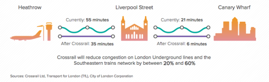
    And below is a neat diagram that I found in this City of London report. I think it does a good job summarizing some of the spatial impacts of The Crossrail.

    image

    In the past I’ve been negative about John Tory’s SmartTrack proposal, which is clearly inspired by The London Crossrail. I had my reasons for that. But I want to be clear that I am not in any way negative on Regional Express Rail as a mobility solution.

    Toronto would benefit greatly from RER and Metrolinx is working diligently to deliver it to the region. I can’t wait for that to happen so I can drive even less than I already do.

  • Teaming up to fix Toronto’s traffic troubles

    image

    “This will be a game changer and will establish Toronto as a leader in running a truly smart city.”
    – John Tory, Mayor of the City of Toronto

    Yesterday I registered for a hackathon called TrafficJam that’s taking place this October 2 – 4, 2015 here in Toronto. It’s being organized by Evergreen CityWorks and the City of Toronto, with the goal of fixing Toronto’s traffic troubles.

    Tickets are free, but going fast. If you’re interested in this sort of thing, I would encourage you to sign up today. And if you do register or are already registered, drop me on a line so we can connect. I’m excited to see what kind of solutions we’re all able to come up with over the course of a weekend.

    But as I was registering and reading through the website, I couldn’t help but think about some of the traffic problems that we won’t be solving over the hackathon weekend, namely the politicization of transportation planning in this city.

    As an example of that check out a post by transit blogger Steve Munro called, The Vanishing Relevance of SmartTrack

    SmartTrack is the transit platform that Mayor John Tory ran on last year. And this post explains why it is unlikely to achieve its pitch promises.

  • The ultimate Toronto transit map

    image

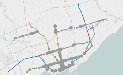
    If you live in Toronto and only give serious thought to one thing today, it should be to this interactive transit map created by Metro.

    The map shows all existing, planned, and proposed transit lines in the city, and then overlays population densities, commuting patterns, household income, and so on. It’s a super valuable map that I think reveals a lot about how we should be focusing our energies to get Toronto moving.

    So what sorts of things does it tell us? I’ll give 2 examples.

    If you look at commuting patterns across the Bloor-Danforth subway line, you’ll see that Runnymede station in the west is where people switch over from taking transit to driving. People west of that station tend to drive. Naturally, it also happens to coincide with where population densities start to fall off.

    By contrast, if you look at the east side of the city along the Danforth and beyond, the entire stretch more or less relies on transit to get around. Part of this likely has to do with income levels, but it’s also because of the availability of the Gardiner Expressway. There’s no equivalent in the east end. Dylan Reid of Spacing Magazine believes this makes a case for some sort of road pricing along the Gardiner, and I would agree.

    As a second example, look at the population densities along the proposed Downtown Relief Line, Finch LRT, and John Tory’s SmartTrack line. Outside of the core, the population densities are relatively low along the proposed SmartTrack line – which is never a good thing for rapid transit.

    There’s also no Sherbourne station on the SmartTrack line, which happens to have the highest population density across the entire Relief Line – 22,131 people per square kilometre! That’s more than any other stop along the Yonge-University subway line except for Wellesley station.

    I’ve written about this a lot before, but I think we need to do a better job of matching up transit investment with expected customer demand. Too often we let politics get in the way of rationale decision making. Maybe it’s time we did something like set minimum population densities. If you want a subway line in your area, you have to first bring the people.

    What else does this map tell you?