
Daily insights for city builders, delivered every morning at 6 AM ET. I’m Brandon Donnelly — a Toronto-based real estate developer and founder of Globizen. I’ve been writing here since 2013.

Tag: smartphone data

  • Mapping spring breakers

    The following video was published last week showing the “secondary locations of anonymized mobile devices that were active at a single Ft. Lauderdale beach during spring break.” Said differently, the company used anonymized mobile phone data to see where spring breakers went after they left the beach. This was in order to better understand how they may have contributed to the spread of COVID-19. If you can’t see the video below, click here.

    The video is astonishing for two reasons. One, it shows you the extreme reach of just one beach in South Florida. Imagine if they had analyzed all of the beaches up and down the coast. And two, a lot of you are probably freaked out that this sort of mobile phone data is available to private companies. If you’d like to learn more about how this all works, check out this opinion piece from the New York Times.
  • Puerto Rican migration during and following Maria

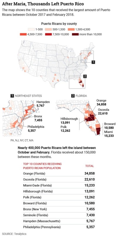
    Teralytics recently looked at data from 500,000 smartphone users to determine how, when, and where Puerto Ricans moved between August 2017 and February 2018 during and following Hurricane Maria – generally considered to be the worst natural disaster on record for the area. 

    CityLab published the data here and along with the following maps:

    image

    It shows the locations and the top 10 counties that received Puerto Rican population during the above time period. Florida and the Northeast are at the top of list, which isn’t all that surprising. Privacy concerns aside, it is once again an example of the kind of granular data that we now have access to. Prior to this data being available, all we apparently had was estimates.