Daily insights for city builders, delivered every morning at 6 AM ET. I’m Brandon Donnelly — a Toronto-based real estate developer and founder of Globizen. I’ve been writing here since 2013.

Tag: seoul

  • Seoul’s infamous modernist megastructure

    Seun Sangga is Seoul’s first mixed-use complex.

    Constructed between 1967 and 1972, the elaborate structure sits atop a strip of land measuring 50 m x 1.2 km, which had been flatted during the Second World War as a way to contain the spread of fire in the event of an air raid and to act as an evacuation corridor.

    It’s a modernist development that is very much of this period. It’s massive, complicated in section and, in many ways, completely disconnected from its surrounding urban context. Flanking the various buildings are elevated and covered walkways.

    So it is perhaps not surprising that this development has followed a similar fate to many others of this era. While it was initially viewed as being quite modern and desirable — it was one of the first buildings in Seoul to have elevators — Seun Sangga was quick to start showing signs of decline.

    In fact, by as early as the 1970s, the complex became known for its porn shops and a bunch of other informal economy-type activities.

    It’s an interesting, though familiar, story.

    If you’d like to learn more, I recommend you check out this episode of the Urbanist and this article from The Architectural Review. The photos in the article are good accompaniment to the audio-only Urbanist episode, so make sure you flip through them.

  • Building a home on a constrained site

    I’m so predictable. This is the kind of house that tends to grab my attention: modern design, relatively small footprint (~7.8m x 12.3m), narrow street (~4m), and panoramic views (of Seoul). But what does it take to actually build a house like this in an urban fabric as dense as Seoul’s?

    If you read TIUM Architect’s description (using Google Translate for those of us who don’t speak Korean), you’ll see that the house was built out of concrete and steel, but that concrete trucks couldn’t stage on the narrow and dead-end street.

    So what they ended up having to do was build a 100-meter concrete conveying pipe (~328 feet) and staging somewhere else. It was such a pain in the ass that they only wanted to do this for the foundations. The rest of the house was built out of steel. (I think because of the clear spans that they wanted.)

    Sometimes small infill projects aren’t as simple as they may seem. In this case, the lot size is 92 m2. The building footprint is 51.53 m2 (56% lot coverage). And the total floor area is 136.52 m2.

    Photo: Lee Hanul via ArchDaily

  • This is how many more people Toronto could house if it increased its population density

    As a follow-up to yesterday’s post about infill housing and overall urban densities, let’s look at some basic math.

    The City of Toronto has an estimated population of 3,025,647 (as of June 2023) and a land area of 630 square meters. That means that its average population density is about 4,803 people per km2. Obviously this number will be higher in some locations, and lower in others. But overall, this is the average.

    Now let’s consider how many people we could actually fit within the existing boundaries of the city (city proper not the metro area) if we were to simply match the average population densities of some other global cities around the world.

    Again, what this chart is saying is that if we took the same physical area (Toronto’s 630 square meters) and just increased the population density to that of, say, Paris, we would then have a total population of over 13 million people and we’d be housing an additional 10,011,573 humans on the same footprint.

    I am not suggesting that this is exactly what should be done. (Though, you all know how much I love Paris.) What I’m suggesting is that calling a place “full” isn’t exactly accurate. How would you even measure that? What someone is really saying is that they are content with the status quo in terms of built form and density.

    Note: The above population densities were all taken from Wikipedia, except for Toronto’s figures, which were taken from here.

  • Seoul crush

    We have spoken a lot over the years about the benefits of narrow and pedestrian-focused streets. Most recently, I even ran around Europe with a laser distance measuring device to collect a few field samples. Here’s an example from Marseille and here’s an example from Sicily.

    But given all this, I think it is important to recognize that what happened in Seoul over the weekend — a deadly crowd crush that killed over 150 people — is both a horrible tragedy and a result of too many people in a narrow and pedestrian-focused street. So clearly there can be a flip side to what we talk about here. At the time of writing this post, investigations were still ongoing.

    I am not a crowd-control expert, but I have spent time in dense Asian cities during major events and holidays, and never have I felt so claustrophobic. I have lined up for hours to get into subway stations and I have lined up to get into entire city districts — presumably because they were trying to avoid things like what happened this past weekend.

    My heart goes out to all of the people and families that were impacted by this horrific incident.

    🇰🇷 🇨🇦

  • [Film] CROSSROADS: Life in the Resilient City

    Five cities. Five stories.

    Here is a short film by Nils Clauss and Neil Dowling, which recently premiered at the Seoul Biennale of Architecture and Urbanism. (If you can’t see the embedded video above, click here.) The film is named after this year’s Seoul Biennale (which is going on right now until the end of October) and focuses on five crossroads of city life that were put forward by French architect Dominique Perrault: above/below, heritage/modern, craft/digital, natural/artificial, and safe/risk.

    To illustrate these urban crossroads, the filmmakers visit New York, Seoul, Mumbai, Paris, and Nairobi. But instead of interviewing so-called “experts”, these crossroads are examined from the perspective of people just living through them. The documentary is very well done. And having just come back from Paris, I can say that I think they chose the right city to tackle the heritage/modern crossroad.

    To close things out, I would like to share one screenshot from the film. Here you can see an ingenious little urban table that slips over a street bollard. It’s just perfect. There is so much that can be done to better activate our streets and public spaces.

  • South Korea’s idiosyncratic and counterintuitive home rental system

    Over the weekend I learned about a unique feature of South Korea’s housing market. It’s called jeonse. And the way this housing contract works is that, instead of tenants paying a monthly rent to their landlord, they pay a huge lump-sum amount up front. Usually this “key money” is equal to somewhere around 50% of the value of the home, but oftentimes it’s even higher (60-90% range). In 2014, the average cost of a jeonse deposit in Seoul was somewhere around US$300,000.

    In exchange for this huge lump-sum amount, jeonse tenants are able to live in the property for a period of time (usually 24 months) without having to pay any rent. Because what they are actually doing is paying via the opportunity cost of having their money tied up during their occupancy. Jeonse landlords are free to invest these lump-sum deposits however they see fit. The money they make from investing is their “rent” on the property. (The deposits are secured through a lien on the home, but of course that isn’t without some risk.)

    At first glance, this seems entirely counterintuitive. If you have hundreds of thousands of dollars available to you, why not buy? Why hand it over to a landlord so that they can go invest in things? Well, usually when there’s a marketplace for something it is because both sides stand to benefit. And in this case, the jeonse system supposedly emerged as the country was developing and people were rapidly urbanizing. Credit wasn’t widely available and so the jeonse system grew to help both tenants and landlords.

    For tenants, it was cheaper than owning a place outright and the “rent-free” period allowed them to more easily save up so that they could eventually buy. And for landlords, it was access to low-cost capital and the opportunity to invest in other money-making stuff. Some even credit the jeonse system with being instrumental in South Korea’s rapid rise in the second half of the 20th century.

    But is it still relevant today? Good question.

    The data suggests that it could very well be on the way out. Jeonse deposits have been declining for years and, based on this, it was overtaken in 2012 with more people choosing to pay rent on a monthly basis. As of 2019, it had grown to over 60% of tenancies in Seoul. And so it feels like the end could be near. But if any of you have first-hand experience with renting in South Korea, I would love to hear from you in the comment section below.

    Photo by Cait Ellis on Unsplash

  • What’s next for cities? Probably more of the same.

    I am surprised, although maybe I shouldn’t be, by how quickly many seem to be allegedly turning their back on cities. According to the New York Times, cities were “losing their allure” well before this pandemic, and this might just be the tipping point. The underlying argument: Density is bad. We should probably all move somewhere bucolic, where the cost of housing is less and work isn’t so stressful. Zoom only when necessary.

    But as the chief economist for Indeed, Jed Kolko, rightly points out in the article, how people behave (and think) during a global pandemic is probably not a great indicator for how they will want to live their lives when this is all over. It’s also not clear that urban density is really the contributor of spread. Hyper-dense cities such as Seoul and Hong Kong have been performing relatively well. (Joe Cortright has some thoughts on this.)

    Once we get to the other side, we will see the data and we will get a better understanding of this current situation. And then in hindsight, we will find ways to rationalize the outcomes to ourselves. In the interim, I’m not about to bet against cities. Here’s how Paul Romer, professor at New York University, put it in this recent interview in City Journal:

    “I think the underlying economic reality is that there is tremendous economic value in interacting with people and sharing ideas. There’s still a lot to be gained from interaction in close physical proximity because such interaction is a large part of how we establish trust. So I think that, for the rest of my life, cities are going to continue to be where the action is.”

    Photo by bady qb on Unsplash

  • The Korean Peninsula

    I just spent the last 7 minutes listening to this brief historical overview of Seoul by The Urbanist, while I bounced around the city on Google Street View, admiring the coverage of their transit network and the density of their low-rise neighborhoods. 

    I love Street View and I love using it to explore cities.

    One of the things I liked about The Urbanist episode –  beyond it being a good soundtrack while I explored – is that it talks, albeit briefly, about why Seoul is located where it is today. 

    I am always curious about this when it comes to cities. I mean, who was it that decided, yup, this is going to be the spot. Because it’s generally a pretty sticky decision once it is made.

    You may also find this 2014 NASA photograph of the Korean Peninsula interesting. The nighttime sky renders up a pretty stark contrast between North Korea and South Korea.

    According to NASA, per capita power consumption in North Korea and South Korea is 739 kilowatt hours and 10,161 kilowatt hours, respectively. That’s why the satellite photo looks the way it does.

  • Smart sewers may soon analyze our poop

    On September 2, 2017, a research project by several MIT laboratories – called Gangnam Poop: Underworlds in Seoul – will debut at the Seoul Biennale of Architecture and Urbanism.

    Here’s an excerpt from the exhibition description:

    A vast reservoir of information on human health and behavior lies in our sewage, and this resource is untapped. We imagine a future in which sewage is mined for information that can inform policy makers, health practitioners, designers, and researchers alike. Such is the idea behind Underworlds: a cross-disciplinary data platform for monitoring urban health patterns, shaping more inclusive public health strategies, and pushing the boundaries of urban epidemiology.

    For this exhibition and “proof of concept”, they analyzed three distinct neighborhoods in Seoul, using an aptly named sewer robot called Luigi. 

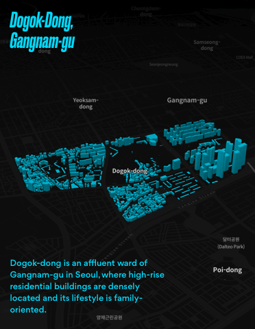
    Gangnam-gu (shown above) is an upper-class high-rise residential area. Mapo-gu is an emerging artist and designer enclave. And Seongbuk-bu is a hillside village with detached houses and an older demographic.

    In each case, they mapped out the bacterial populations found beneath each neighborhood. Interestingly enough, the different areas revealed different bacterial occurrences. You can see those diagrams here.

    I often think of healthcare as being very reactive. A future like the one this exhibition is imagining would be far more proactive. And that would be a very good thing.

    Image and project by MIT Senseable City Lab. Gangnam Poop: Underworlds in Seoul. Commissioned by Seoul Biennale of Architecture and Urbanism

  • On boulevards vs. freeways

    Toronto’s Director of Urban Design, Harold Madi, recently did a 20 tweet series on boulevards. And since today is Gardiner East day, it seems appropriate to share it with you all. Thanks to Shawn Micallef for using Storify to put it all together neatly. If you can’t see all the tweets below, click here.