Daily insights for city builders, delivered every morning at 6 AM ET. I’m Brandon Donnelly — a Toronto-based real estate developer and founder of Globizen. I’ve been writing here since 2013.
The University of Toronto is looking for a Director, Real Estate to manage their tri-campus portfolio of income producing real estate, as well as the development opportunities that they have on and adjacent to their three campuses. The downtown campus alone is over 120 buildings across 130 acres.
A good friend of mine is helping with this search; I went to the University of Toronto (twice); and I believe that institutions, such as U of T, play an important city building function. So I’m sharing this opportunity with all of you today. For more on the University’s development strategy, click here.
They are looking for someone with 10+ years of experience. The salary will be competitive and commensurate with this level of experience. And you would be reporting directly to the Chief of University Planning, Design & Construction.
If you’re interested, you can apply here. You have until January 25, 2019 to do that. I hope the position gets filled with a star. Also, sorry if this post isn’t relevant to you. Regularly scheduled programming will resume tomorrow.
It’s still early days and transit guru Steve Munro hasn’t yet published any before and after route performance. He will. But already the sentiment seems to be clear: This shit is working. There are many recounts of people’s commute times being more than cut in half.
As somebody who walks this stretch of King every day, this isn’t surprising to me. There has been a dramatic reduction in the number of cars on the street.
What is perhaps surprising is that none of the surrounding streets seem to be any busier. I would like to see the data, but it feels as if most of the cars have simply disappeared. Are more people now taking transit? Has this been your impression?
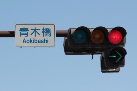
Of course, the pilot isn’t perfect. What is not working are the signs that tell drivers they can’t drive through most of the intersections (only turn right). The circular green lights confuse them or they simply don’t care.
There have been suggestions for better signals, such as this one:
And if the pilot in its current incarnation does stick, I am sure there will be many additional improvements like this one made. But even at this early stage, Toronto is calling the pilot a “transit miracle.”
When City Council approved the pilot in the summer it had a preliminary cost estimate of $1.5 million. (Figure excludes the lost parking revenue associated with removing approximately 180 on-street parking spaces).
This is a relatively minuscule amount considering it has had an immediate impact, basically overnight, on the commute times of the 65,000 or so people who use this line every day.
And it feels even more minuscule when you consider that our Scarborough Subway extension is expected to cost $3.35+ billion to build and only service around 64,000 people a day when you look far into the future – 2031 to be exact.
The lesson here on King Street should be that light rail and surface transit routes can move lots of people very efficiently and cost effectively when you empower them to do precisely that.
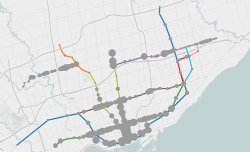
The map shows all existing, planned, and proposed transit lines in the city, and then overlays population densities, commuting patterns, household income, and so on. It’s a super valuable map that I think reveals a lot about how we should be focusing our energies to get Toronto moving.
So what sorts of things does it tell us? I’ll give 2 examples.
If you look at commuting patterns across the Bloor-Danforth subway line, you’ll see that Runnymede station in the west is where people switch over from taking transit to driving. People west of that station tend to drive. Naturally, it also happens to coincide with where population densities start to fall off.
By contrast, if you look at the east side of the city along the Danforth and beyond, the entire stretch more or less relies on transit to get around. Part of this likely has to do with income levels, but it’s also because of the availability of the Gardiner Expressway. There’s no equivalent in the east end. Dylan Reid of Spacing Magazine believes this makes a case for some sort of road pricing along the Gardiner, and I would agree.
As a second example, look at the population densities along the proposed Downtown Relief Line, Finch LRT, and John Tory’s SmartTrack line. Outside of the core, the population densities are relatively low along the proposed SmartTrack line – which is never a good thing for rapid transit.
There’s also no Sherbourne station on the SmartTrack line, which happens to have the highest population density across the entire Relief Line – 22,131 people per square kilometre! That’s more than any other stop along the Yonge-University subway line except for Wellesley station.
I’ve written about this a lot before, but I think we need to do a better job of matching up transit investment with expected customer demand. Too often we let politics get in the way of rationale decision making. Maybe it’s time we did something like set minimum population densities. If you want a subway line in your area, you have to first bring the people.
If there are two things we like to talk about here in Toronto it’s that there are a lot of condos going up and that it’s becoming increasingly difficult–some would say impossible–to get around. Just this past weekend, I had 2 or 3 people tell me that biking is the only practical way to get around downtown and that it’s fairly easy to outwalk a streetcar on either Queen Street or King Street.
Usually these statements are followed by a question, asking what the city is doing to address these issues. The unfortunate reality is that I think urban mobility is going to get worse before it gets better (although I am thrilled about the Eglinton Crosstown line now under construction). If you’re a regular reader, you’ll know that I’m a supporter of a Downtown Relief Subway line and that I was disappointed by John Tory’s recent transit proposal.
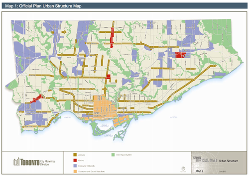
The best way to explain why I feel this way is to talk about how and where Toronto is growing. In my post on John Tory’s transit proposal, I talked about how Toronto is developing in the shape of an upside down letter T. And the reason for that is because in the city’s Official Plan, the “Downtown and Central Waterfront” area is identified as a growth node and is shaped more or less like an upside T. It’s the light orange in the following map.
In addition to the downtown core, the areas shown in red are earmarked as “Centres” for growth. There’s one in each borough (Etobicoke, North York and Scarborough) and one at Yonge & Eglinton, which most people would consider to be the heart of midtown. Finally, you have the “Avenues” which are the greenish brown lines on the above map. Those are areas that city also hopes will accommodate future growth.
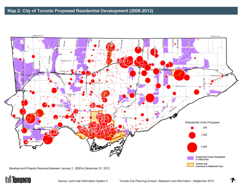
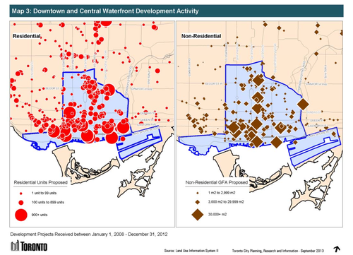
Now, let’s look at where development is happening in the city. Here’s residential development from 2008 to 2012. The biggest circle represents 2,000 proposed residential units.
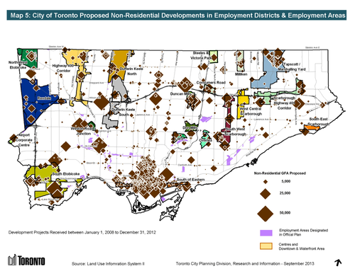
And here’s non-residential development. The largest diamond represents projects with a non-residential floor area greater than 50,000 square meters (~540,000 square feet).
What should become immediately apparent is that growth–particularly on the residential side–is happening more or less according to plan. The biggest “outliers” are really the development happening along Mimico’s waterfront and all the development happening along Sheppard Avenue East. But those are because of the water and the Sheppard subway line.
In both the residential and non-residential cases though, the downtown and central waterfront area is quite clearly receiving a significant share of the development happening in the city.
Which always makes me wonder: Why are we so reluctant to build proper transit in the core?
The city’s Official Plan is clearly funneling growth to downtown and yet we continue to propose, fund, and build subway lines in areas where the population densities are lower and ridership levels will inevitably be less. Which ultimately means that the required government subsidies to keep those lines operating will be higher.
I’m not suggesting that the inner boroughs don’t also need top notch transit and infrastructure. They absolutely do. But I get frustrated when politics trumps rational city building. And so does everybody else who’s stuck with inadequate mobility options.
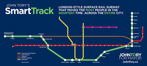
Yesterday Toronto mayoral candidate, John Tory, proposed a transit line called SmartTrack. It’s part of his One Toronto transit plan. If you’re interested in watching the full 30 minute announcement, click here.
As somebody who came out of the gate as a strong proponent of the “Yonge Relief Subway Line” (and as somebody I immediately supported for that reason), this proposal first hit me yesterday as a disappointment. Not because I don’t think we need a regional express rail network in the region (we do), but because I feel that he is backing away from that initial commitment and depriving the core of the transit infrastructure it needs.
As soon as I found out about the plan, I immediately emailed one of my friends at Metrolinx. I told him I thought it was an “epic fail”. He pushed back and asked me to consider the merits of Tory’s plan. After having slept on it (and calmed down), I’m now prepared to talk about both the benefits of SmartTrack and why I was disappointed.
SmartTrack is basically a regional rail plan, intended to move people from the outer and inner suburbs to and from downtown using an integrated fare system. That is, riders will not have to pay a separate fare to transfer from subway to SmartTrack. 90% of the track needed for the plan is already existing, which means it will be cheaper and quicker to build compared to the full relief subway line. It will also bring employment centers such as Airport Corporate Centre in Mississauga into the transit network. For these reasons, the SmartTrack plan would certainly be beneficial for the region.
But, there’s a densities mismatch.
If you look at the number of stops proposed in Scarborough and Markham, and compare it to the number of new stations proposed for downtown (1 – Spadina station) and the downtown shoulder neighborhoods (2 – Liberty Village and the Unilever site), the plan starts to look lopsided. SmartTrack would help residents of downtown get out to the suburbs, but it would do little to help them move in and around the core.
If you look at the way Toronto is intensifying on a map, it looks like an upside down letter T. Density now hugs the waterfront and then follows our subway lines up north. I believe that the SmartTrack plan would help to relieve the pressures on those subway lines, but I don’t think it adequately addresses the bar of the T that now runs parallel to the lake.
So while I do think that the Toronto region would be well served by regional express rail, I don’t think we can forget about the central part of the city. This shift in focus may have something to do with where Tory believes his voter base now sits, but let’s not forget that there’s a strong correlation between population density and transit ridership levels.
Now, let’s hear from you. What do you think of Tory’s One Toronto plan and SmartTrack proposal?
There’s a fairly real divide between east and west here in Toronto. When people talk about real estate or describe the kind of person they are, they often say things like: “I’m an east end kind of person” or “I only want to buy on the west side.” There’s such a split that somebody recently said in a meeting I was in that the east vs. west real estate divide is like Christianity vs. Judaism.
Historically, the west has generally been considered more desirable than the east–regardless of what scale you’re looking at. Downtown west vs. downtown east, Etobicoke vs. Scarborough, and so on. And for whatever reason, this seems to be the case in a lot cities I’ve been to. Consider Montreal, Vancouver, New York, and London, to name a few.
But lately, I’ve been noticing a growing acceptance of the east side. Friends are telling me that, even though they don’t know the east all that well, they’re almost agnostic to which side they buy a home on.
At the same time, we’re seeing Toronto’s development boom spread to the east along streets like Church and Jarvis; paralleling the kind of intensification we’ve already seen on the west along Bay Street, University Avenue and further. I’m also noticing a lot of west end restauranteurs open up on the east side. See Carbon Bar and Gusto 501 as two recent examples.
But with the neighborhoods like the Distillery District and Leslieville attracting lots of yuppies and with neighborhoods like Regent Park and the West Don Lands coming online, it shouldn’t come as a big surprise to you that developers and other entrepreneurs are looking east. Maybe you should too.